
After 3 long days hiking in sweltering heat through the Colombian jungle and sleeping under mosquito nets, we reached the charming ruins of Ciudad Perdida, The Lost City. Built thousands of years ago by the ancient Tayrona tribe, the exact location of the city was lost until the 1970s. Even today only a portion of the vast ancient city has been exposed.
The adventure began with a bumpy jeep ride from Santa Marta to the Sierra Nevadas de Santa Marta and the indigenous village of Mamey. The hike traverses the indigenous lands of the Kogui, Wiwa (Malayo) and Arhuaco who are descendants of the now extinct Tayronas. You can only do this trek in a guided group. Our head guide, Chinto, is Wiwa and throughout the trek he explained the customs and history of the indigenous people of the Sierra Nevada.

Mamey, Ciudad Perdida Trek
The hike started at only 180m elevation. It was very hot and humid as we hiked through the suffocating dense jungle with only occasional views of the surrounding green mountains. By mid morning we were hot and thirsty and were thrilled to find a lady making freshly squeezed orange juice. It was the most delicious sweet orange juice we’d ever had. Finally, after a full afternoon of slowly making our way up the mountain we arrived at a lovely camp with amazing views.


Ciudad Perdida Trek 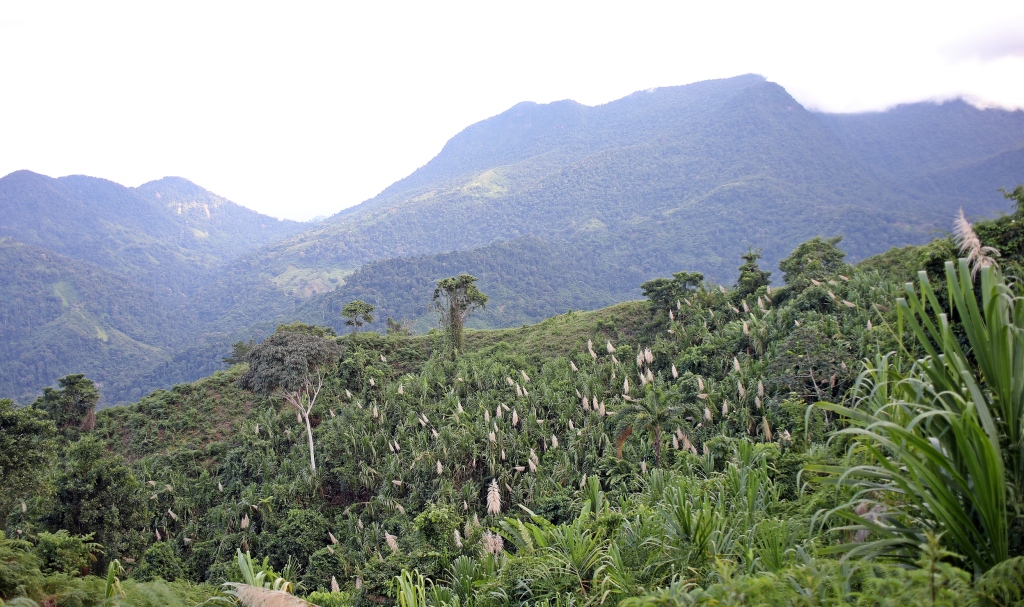
Ciudad Perdida Trek 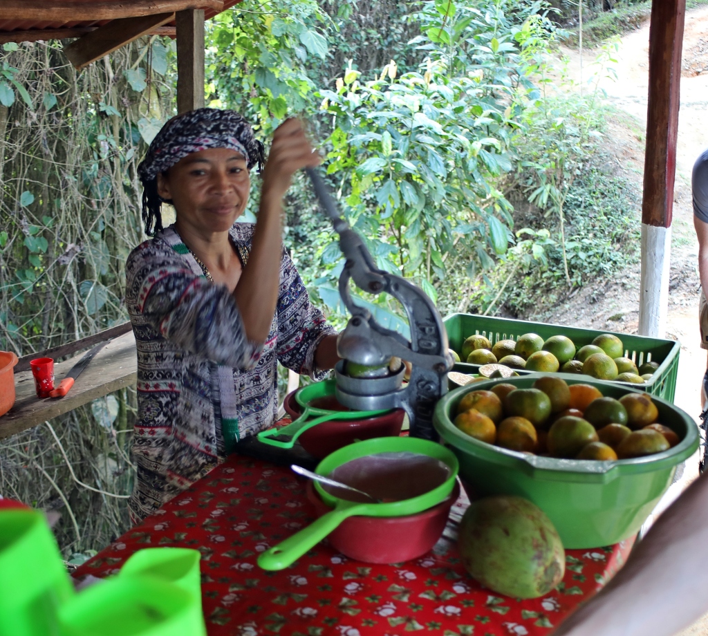
Making orange juice, Ciudad Perdida Trek 
Flowers, Ciudad Perdida Trek 

Camp 1, Ciudad Perdida Trek
After a good sleep on mosquito net covered bunkbeds, we were up early the next morning. The trail climbed up and down narrow, muddy tracks following the Rio Buritaca. These trails are regularly used by the indigenous people to travel between villages. We saw a few on the trail who were dressed in traditional white clothes. They are very shy, most wouldn’t even look at us. The indigenous tribes in this area wear white to honour the snow on the tops of the sacred Sierra Nevada mountains. We should have been able to see these sacred mountains on our trek, but there was too much cloud cover.

Sunrise,Ciudad Perdida Trek 
Rio Buritaca, Ciudad Perdida Trek 
Ciudad Perdida Trek 
Indigenous couple, Ciudad Perdida Trek 
Ciudad Perdida Trek
In addition to wearing white, the men carry bags full of coca leaves and a poporo. It is a hollow gourd given to each man when they come of age. The men keep the same poporo for their entire life. Inside the gourd is a paste made from crushed seashells. The men continuously chew coca leaves and suck on a stick which is dipped in the paste. Then they rub the stick on the outside of the gourd. Throughout their lifetime, the popora becomes a large yellow ball composed of this paste. They say it represents the knowledge that they have gained throughout their life. When indigenous men meet, rather than shake hands, the exchange coca leaves from their personal bags.

Chinto and his poporo, Ciudad Perdida Trek 
Indigenous farmer, Ciudad Perdida Trek 
Exchanging coca leaves in a greeting, Ciudad Perdida Trek
The indigenous grow coca on their lands for this traditional custom. Their culture says that the women must pick the coca leaves as they are more skilled at it than men. Women are not, however, allowed to chew it. I think the rule was created by the same person who decided they should wear white in a muddy jungle.
As we walked through the jungle we could see large areas which had bare cutouts. These areas used to be coca fields owned by drug cartels. The Colombian government destroyed these fields and still monitor the area to ensure they are no longer used.
Bare patches of former coca fields, Ciudad Perdida Trek 
Bare patches of former coca fields, Ciudad Perdida Trek
During the hike we also saw a few indigenous houses which are made from mud and bamboo. They use vine for rope to tie the bamboo together and palm leaves to cover the roof. We passed one community with several of these houses but were told that these are just used for tribe meetings. Thirty-five families come together every two weeks where they manage both community business and perform traditional rituals. The rest of the time most live higher up in the jungle.

Indigenous homes, Ciudad Perdida Trek 
Indigenous meeting village, Ciudad Perdida Trek 
Indigenous village, Ciudad Perdida Trek
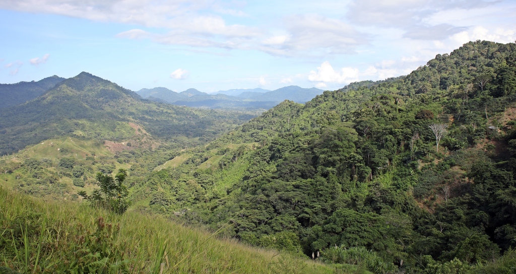
As we climbed higher up the mountain, the trail became very steep with a lot of mud and slippery rocks. We saw many birds and heard even more in the dense trees. There were many colourful butterflies and a few spiders too. By mid-morning on the second day, soaked in sweat, we arrived at a side trip to an amazing waterfall. The water powerfully cascades over a rocky cliff and forms a lovely swimming pool at its base. We hiked for 10 or so minutes in our bathing suits and, although it was cold, we had an incredibly refreshing swim.

Sierra Nevadas, Ciudad Perdida Trek 
Macaw, Ciudad Perdida Trek 
Spider, Ciudad Perdida Trek 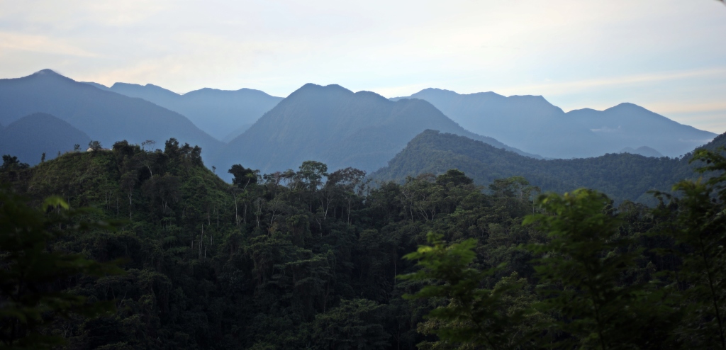

Ciudad Perdida Trek 
Wiwa Camp waterfall, Ciudad Perdida Trek 
Wiwa Camp waterfall, Ciudad Perdida Trek
That night our camp didn’t have bunk beds. Instead we slept restlessly in hammocks and awoke with sore necks and backs, but excited for the day. The day was full of challenges, the first was to cross the fast moving Rio Buritaca. The water was thigh deep, but during rainy season, it can be much deeper. Soon after the river crossing, we reached another challenge, the dreaded 1200 steps. Stone steps, built by the ancient Tayrona people, led up to the Lost City. The steps were very slippery and were placed at uneven heights. Some were tall, knee-high steps and others were only small making it difficult to get your rhythm. At the top of the steps we had our first glimpse of the stone circles of Ciudad Perdida.
Our guide, Chinto, led us in an indigenous custom before being allowed to enter the site. We formed a circle around a group of stones. Chinto told us to release our negative feelings and only allow positive thoughts. Then we each took a coca leaf and placed it on a centre stone as an offering. Releasing negative thoughts is an important custom to the indigenous.

Ciudad Perdida Trek 
Crossing the Rio Buritaca, Ciudad Perdida Trek 
Ancient steps, Ciudad Perdida 
Ancient stairs, Ciudad Perdida 
Ciudad Perdida
Ciudad Perdida was built thousands of years ago and is set on terraces on the side of the mountain. It was an important city but was abandoned without its exact location known. In the 1970s farmers began finding gold and jewels in the ground. The trail of jewels led them to ruins of the Lost City.
Today only a portion of the city has been uncovered. The ruins consist of round platforms bordered by stones set on terraces on the side of a mountain. The platforms would have been the location for bamboo homes similar to the ones we passed on the trek. We also saw two different maps carved into large stones that depict the area’s landscape including mountains and rives. The maps also show the ancient trails between Tayrona villages. We walked up between the terraces imagining what it would have looked like a few thousand years ago.

Ciudad Perdida 
Ancient map, Ciudad Perdida 
Chinto, Wiwa guide, and an ancient map, Ciudad Perdida Trek 
Stone circles, Ciudad Perdida 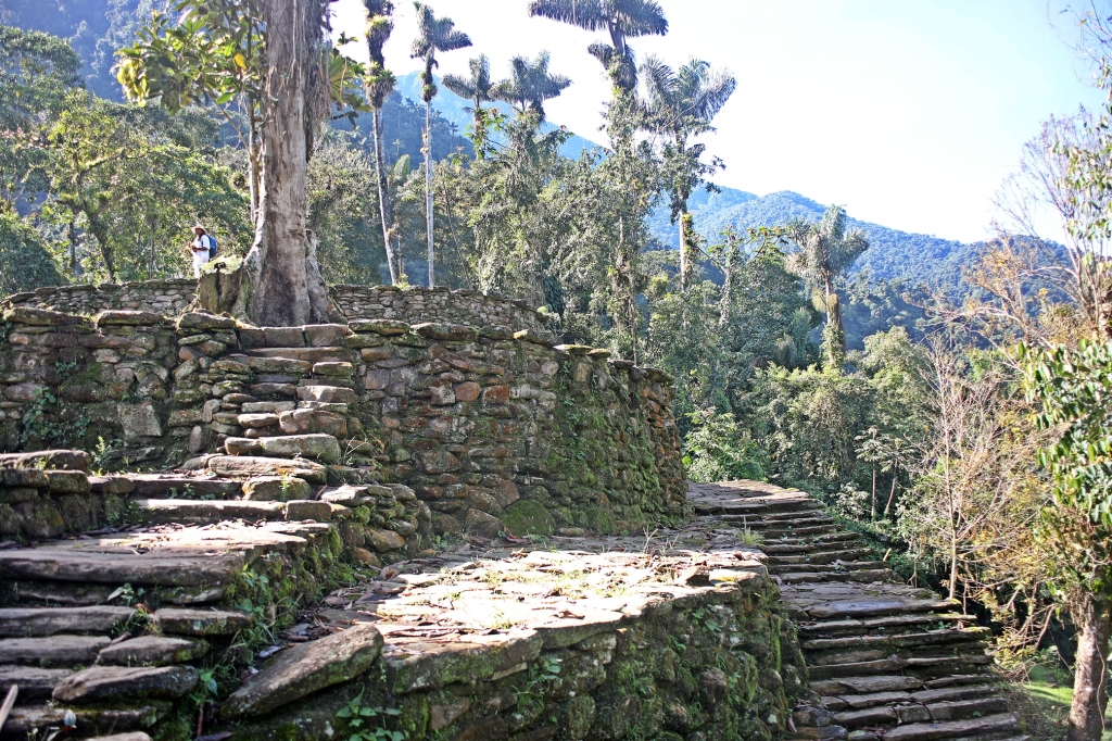
Ciudad Perdida
Finally, we reached the highest level at 1200m, where we could look down upon parts of the city for a tremendous view. The highest terraces are set on a ridge and would have been the location for the main meeting houses. These large circles bordered by stones, are set on an open ridge with lovely views of the jungle covered mountains of the Sierra Nevada.

Ciudad Perdida 
Ciudad Perdida 
Ciudad Perdida 
Ciudad Perdida 
Ciudad Perdida
Each indigenous community is led by a Spiritual Leader, called Mamo, and his wife, called Zaga. We went passed the current Mamo’s Residence. There are two bamboo buildings, one for him and one for his wife. In addition to providing spiritual guidance, members of their community bring their tribal concerns or grievances to this couple. The issues are resolved based on the Mamo and his wife’s decisions.
On the backside of the mountain are more of the stone circle where more homes would have been located. Researchers believe that not even half of the Lost City has yet been discovered.

Mamo house, Ciudad Perdida 
Indigenous kids, Ciudad Perdida Trek 
Ciudad Perdida
After visiting the Lost City we still had to walk back down the 1200 steps which was even more challenging to get down. After the steps we hiked back through the hot, steamy jungle. At the end of the day we stopped at a lovely ‘pool’. A large, calm pool in the middle of the Buritaca river was perfect for a soothing swim. After we were out of the water, we were told that highly venomous serpents come to the pool at dusk! Maggie would defiantly not have gone swimming if we were told this earlier. Since we didn’t know, it was a relaxing end to a fantastic hike. For trek details click here.
Minca
In another part of the Sierra Nevadas is the laid-back village Minca. This small mountain town has several backpacker hotels and hostels and surprisingly, very good restaurants. One morning we had a leisurely breakfast where we watched several iguanas as they climbed around a large tree seeking out the best sunbathing spots.
As it is a mountain town, there are several waterfalls within walking distance. Marinka Waterfall is only 3.8 km (50 min walk) from Minca. It’s a lovely two-tiered waterfall with a nice pool at its base for swimming. There is a wooden boardwalk and stairs to get to the waterfall’s two levels. We even saw a Toucan across the valley. Pozo Azul is a swimming pool in the Rio Minca, but it wasn’t nearly as nice and Marinka. We didn’t even swim at this one.

Minca’s main street 
Iguana, Minca 
Iguanas, Minca 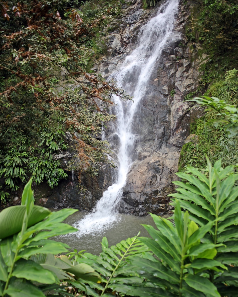
Marinka lower waterfall, Minca 
Marinka upper waterfall, Minca 
Marinka upper waterfall, Minca 
Pozo Azul, Minca 
Waterfall, Minca
Ciudad Perdida trek details:
The trek to Ciudad Perdida travels through the local indigenous territory so a guide is required. We used Wiwa Tours based in Santa Marta and highly recommend them. Their guides and in fact all staff except an English guide/interpreter are indigenous. All companies charge the same fee and hike on the same trail, but Wiwa has 2 camps which are only used by Wiwa Tours. The other camps are very busy as they are shared by all of the other trekking groups.
Day 1 – The day was only 7 km with 460m gain to reach 640m total elevation. It was only 1hr 45 min of hiking, but it took all afternoon as we had many breaks. The first part of the trail was an easy gravel road where we were passed by motorcycles and mules carrying people and supplies further up the mountain. Our first camp, Mirador, was only our groups so it was very peaceful.
Day 2 – 14.7km, 160m elevation gain, but a lot of up and down to reach 800m total elevation. The highest the trail reached today was 850m,. You stop at a waterfall for a swim mid-morning at Wiwa Camp. After the swim the hard part starts with a slippery 350m climb. We stayed in Lorenzo Camp which was quiet and clean, but only had hammocks not beds.
Day 3 – We left camp early in the morning and after 20 minutes reached a busy camp where most groups stayed. We were glad to have had our own camp. There’s a river crossing where you have to wear river shoes or barefeet. It’s a fast moving river, but there’s a rope for support. After the river you have a steep 1200 step stone staircase to reach Ciudad Perdida. There is a little more climbing up to the top terrace. The trek returned back down the slippery, steep steps. At the end of the day you stay in Wiwa Camp where there’s a swimming ‘pool’ in the river.
Day 4 – An easy downhill 1 ½ hour hike back to the start where you have lunch before driving back to Santa Marta.
If you chose the 5-day option, Day 4 is split into two days. Some people were very tired from the hike and needed the two easy days.
Getting to Marinka Waterfall
It’s an easy walk on a gravel road. From the bridge, turn on to the main road, passing Iglesia Minca. Continue on this road until you see the signs to the waterfall. Entry is 5,000 COP, but they’ve built a nice wooden boardwalk, bathrooms and change rooms. There’s a nice, casual restaurant overlooking the waterfall.
Getting to Pozo Azul
Pozo Azul is 4 km (45min walk) away from Minka. From the bridge in town, continue on this road for about 3 km. There are signs when you reach the entrance and still have a long walk along the river to reach the pools. Entry is free, so it was quite busy.
Coming Next: The beautiful beaches of Tayrona Park
For extra pictures from Colombia, click here. For pictures from our other blogs go to Gallery at monkeystale.ca
To read about more of our adventures go to Destinations.
If you like what you read, please comment or share (with credit) using the links below.

We were in Colombia 4 years ago and visited many of the same places you guys are. I am loving your posts as it is bringing back all our memories of how beautiful Colombia is. Looking forward to Tayrona Park as it was one of our favourites.
LikeLiked by 2 people
Thanks Tyson, we love Colombia and the area around Tayrona has definitely been a highlight. Actually all of Colombia has been a highlight!
LikeLiked by 1 person
Amazing experience! How fortunate these indigenous people who don’t have the pollution, oil/gas problems etc of our ‘modern’ civilization. I am sure they have their own life challenges! What a wonderful experience for you. Imagine the civilization who built the lost city! Thank you!
LikeLiked by 1 person
They’re definitely live for the land and off the land. They are very respectful of the environment and many don’t let foreigners on their reservations so they can keep ther lands clean. They are very poor though and have very hard lives. It was very special to be able to visit.
LikeLike
A fascinating post!! As usual, informative, interesting and beautifully illustrated!
LikeLiked by 1 person
Thank you! It was a great hie with an interesting culture, so lots to talk about !
LikeLiked by 1 person
Hello,I might be incorrect, but I think that “Cuidad” could be Ciudad (as per websites)
Fascinating area, thank you for sharing.
A Le Faive
LikeLiked by 1 person
Oh no! Thank you for catching that. Obviously my spell check won’t know the word and apparantly my eyesight is poor. Thanks so much
LikeLiked by 1 person
wonderful post!
LikeLiked by 1 person
Thank you.
LikeLike
Wow! Great description of your trek in addition to beautiful photos!
LikeLiked by 1 person
Thanks Bill!! It was a great trip!
LikeLiked by 1 person
A wonderful post, as always! Sharing coca leaves reminds me of the indigenous people from Taquile Island in Peru.
Thank you for sharing:)
LikeLiked by 1 person
Thanks Christie, I remember the hats of the men from Taquile! Indigenous cultures are so interesting.
LikeLiked by 1 person
Fabulous recount. The customs are interesting and I wonder at their origin, too. Great photos, particularly of the spider.
LikeLiked by 1 person
Thank you. The Tayrona people and actually today’s indigenous in that region don’t have a written language so things have been passed on from generation to generation. Even they don’t know where many of their customs originated. Thanks for reading!
LikeLike
Wow….loved your explanation of the culture and the marvelous photographs. I shared on Twitter.
LikeLiked by 1 person
Thank you so much Michael! That means a lot to us. Maggie
LikeLike
What an incredible place! The hike through the dense and humid forest sounds quite a challenge, although I imagine how fresh the air must have been throughout the journey. It’s amazing how a long time ago a group of people decided to build a city in the thick of a jungle. Places like this are among the reasons why this is such an amazing planet we live in.
LikeLiked by 1 person
That’s very true, it so interesting to try to understand other cultures and why they built in the most unlikely of places. And actually, they continue to live there! It is an amazing world.
LikeLiked by 1 person
Wow, exploring the amazing ruins of Ciudad Perdida sounds like yet another amazing adventure! I like the fact how you are not afraid to challenge yourself – from hiking through the jungle to crossing the rivers and everything in-between. Thanks for sharing and safe travels. Aiva
LikeLiked by 1 person
Thank you Aiva, I’m not sure I want to do another jungle trek for a while. It’s like hiking in a sauna! But it was a great adventure. Thanks for reading!
LikeLiked by 1 person
amazing 😍
LikeLiked by 1 person
Slippery ancient steps sound like quite the challenge, but it was all over for me when I read about the venomous serpents! It really does look like you are trekking into a lost world. Your photos are marvellous. I particularly like the one of the kids. So peculiar about the traditional white clothes with all that mud. Love this post!
LikeLiked by 1 person
Thanks Caroline, other than our guide these kids were the only Wiwa that would interact with us. Their mom was selling bracelets on the way out.
LikeLiked by 1 person
Great post – I’d never heard of this place. I love how it’s not just the man who resolves the problems, but the man and woman together! Progressive!
LikeLiked by 1 person
I know it was interesting how they both settle issues together, but the women are not allowed to do everything, such as chew coca. Still, it was impressive leadership.
LikeLiked by 1 person
Good point.
LikeLike
Heading to Colombia next month.
Our first visit.
LikeLiked by 1 person
You’ll love it! We were so impressed with everything in Colombia. Let me know if you have any questions. Email if you want. By the way I tried to access your site from WordPress app and it said your site url was incorrect? Maybe look into it. Maggie
LikeLike
Thanks for getting back to me. Any safety issues….I will check out my site with WordPress . Thanks for letting mr know
LikeLike
Email me at monkeystale.ca@gmail.com and I’ll explain the safety concerns.
LikeLike
Amazing post. The place Ciudad Perdida looks enigmatic. There is a lot left to unravel in terms of History, Architecture and Culture of the Civilization which existed there.
Great post. Look forward to visiting Ciudad Perdida..!!
LikeLiked by 1 person
Thank you! It was a very nice site. Not as large and sophisticated as Machu Picchu but very nice. Learning about the indigenous culture was a large part of the experience too. Thanks for reading!
LikeLiked by 1 person
Of course. A part of the travel should involve learning from the indigenous people, trying out traditional food and helping preserve the tradition and culture.
Great efforts from your side. Thank you for sharing.. 😊
LikeLiked by 1 person
I wanted to go there but the trek.?! 😑
LikeLiked by 1 person
It wasn’t that bad, but depending on the time of year it can be very muddy. One lady in our group took a motorcycle and then mule for most of it, so it’s do-able.
LikeLiked by 1 person
Would have so done it if I knew that!😂
LikeLike
Did you go to Terradentro?
LikeLiked by 1 person
No we didn’t, I wish we planned our trip better. Have you been?
LikeLiked by 1 person
Yes, it was absolutely amazing. Tombs with spiral huge steps down and painted with weird designs right at the top of the mountain. If you go back hit San Agustin too! Think it would be right up your alley
LikeLiked by 1 person
Good to know for next time! Thanks for the tip.
LikeLike