
It happened in Camp Berlin, 5780 metres above sea level. It felt as though my mind and body were separated into different parts. I could hear my voice, but thought it was coming from another body. This was the first time I had such hallucinations, and once recovered, I understood the dangers of climbing at high altitudes. I still had over 1100 meters to go. Would I make it?
At 6,962 m (22,841 ft.) Aconcagua is the highest mountain outside of Asia and the 2nd highest of the peaks that make up the Seven Summits. My journey to the top of South America began in Mendoza. After meeting the other climbers and our guides we drove to the village of Penitentes. Maggie joined me on this expedition, traveling as far as basecamp. The energy level was high as we were all excited for the expedition to begin tomorrow.
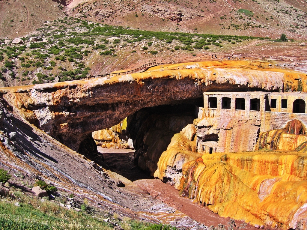
We had a little spare time that day so Maggie and I visited the colourful Puente del Inca. Its not from Incan times at all but rather is a natural arch. The stone was carved by glacial melt and became coated in naturally occurring minerals giving it a bright yellow colour. The remains of an old spa can still be seen from the viewpoint.
The day ended with a bit of chaos. Our guides didn’t speak much English and our Spanish was even worse. As we understood it, we were to meet the group in the lobby that evening. What we were supposed to do was pack one bag with my high camp supplies; warm clothes, mountaineering boots, crampons etc. The muleteers were taking these bags ahead and we wouldn’t see them until basecamp. It was a mad scramble to get my bag packed, trying not to miss important gear, while the muleteers waited. The other climbers all spoke Spanish and didn’t realize that we hadn’t understood the message. From then on one of the climbers who spoke a little more English acted as our translator for the important messages.
Penitentes to Confluencia Camp
Gain – 440 m, Trekking time – 3-4 hours
The trail for the Normal Route begins at the Aconcagua Provincial Park entrance near Puente del Inca. The park officials gave all climbers a numbered plastic bag for collection of their trash. These bags had to be returned at the end of the climb. If not returned there was a substantial penalty. It was a useless attempt at cleaning the mountain though as bags could be returned empty without penalty. I believe it has since changed and now park officials are forcing climbers to return the bags full of both garbage and feces.
It’s a gentle but constant climb up the Horcones Valley following the Rio Horcones as it meanders its way between the tall Andean peaks. The wide valley is bordered by red and brown mountains. Their colour comes from volcanic minerals which also tint the river a chocolate brown hue. The lower part of the valley is sparsely decorated with tufts of grass and a few hardy plants. We were regularly passed by teams of mules carrying loads up to basecamp. They stirred up brown dust as they passed.
Not long into the hike, my objective was within view. At the end of the valley, the snowy peak of Aconcagua was beckoning.


We arrived on a moraine overlooking Confluencia Camp (3390m, 11,122 ft). It’s a semi-permanent tent camp located near the confluence of the upper and lower Horcones Rivers. It’s a busy place as most climbing groups spend 2 nights here to acclimatize in addition to trekking groups who spend a night. We slept in one of the large dome tents. The tent was filled with row after row of bunk beds piled 3 tiers high. It was a difficult place to get a good sleep on a normal night, but we were there on New Year’s Eve. The trekkers did not seem to care that there were climbers in the camp who needed quiet time to ensure a good night’s sleep.

The next day we did an acclimatization trek. We followed the lower Horcones River to Plaza Francia (4100m, 13,451 ft) (3-4 hours). Aconcagua’s massive South Wall began to appear up the valley. The imposing Southern Wall is the steepest side of the mountain. We could see the snow filled runnels of Aconcagua stretching high above. Trekking groups come to this viewpoint before returning back for a night or two at Confluencia and returning to Mendoza.


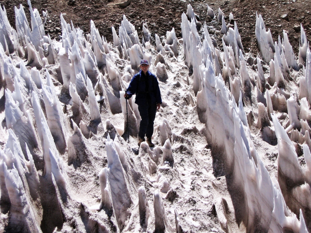
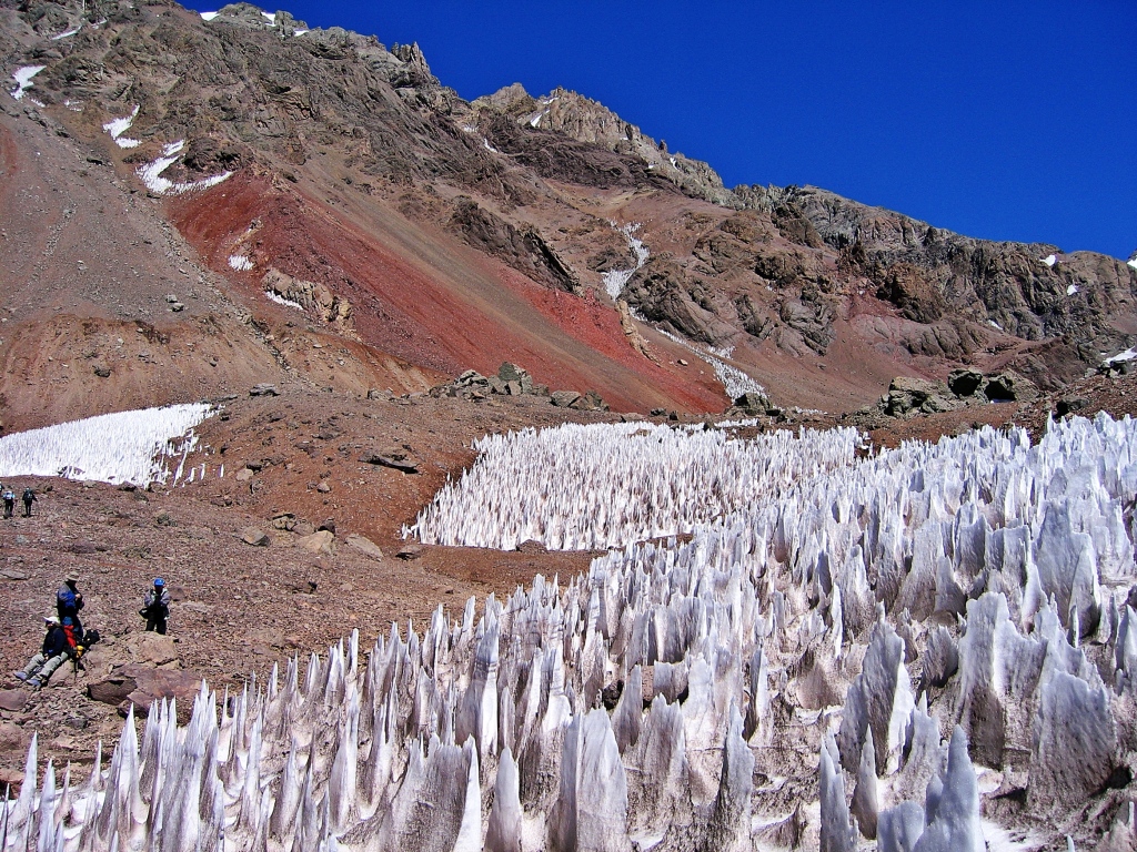
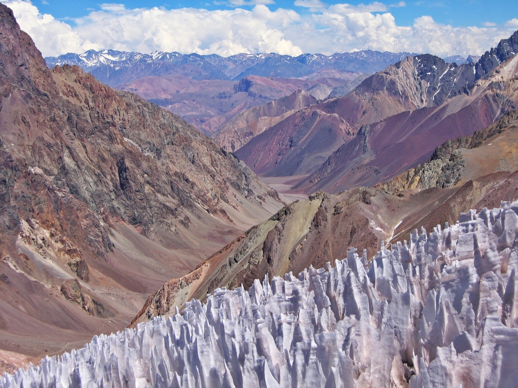
The most unusual part was walking between the interesting Nieve Penitentes. Hundreds of tightly spaced ice spires lean as one so that their sharp peaks are toward the sun. They get there name from their appearance as kneeling worshipers doing penance. These features develop because of the area’s strong sunlight and dry air which causes rapid evaporation. They are found in the Andes above 4000 m.
Confluencia Camp to Plaza de Mulas
Gain – 910 m, Trekking time – 7 hrs
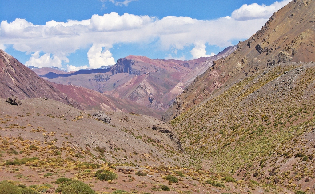
The trek to basecamp at Plaza de Mulas continues up the wide Horcones Valley crossing the 10 km long Playa Ancha (Wide Beach). Some people describe the trek as being an uninspired slog, but by day three we could see wonderful colours. The remarkable desert-like mountains are stunning shades of blue, green, and red from mineral deposits.
There is barely any vegetation above 4000 m but we did see some interesting plants. They must be very hardy to survive in these extreme conditions.


Plaza de Mulas (4270 m /14400 ft) is basecamp for the Normal Route. It gets its name because it’s the furthest point that mules will bring gear and supplies. Hundreds of tents are set up for the season as well as huts for medical personnel and rangers. We stayed in the only hotel which is 1 km from basecamp. Although it was not luxurious, it was a nice treat on a mountain expedition. We could stretch out properly in a bed, hang gear to dry and easily get up to walk around. It’s further to walk, but an added bonus was to see the amazing sunset alpenglow on Aconcagua not seen from the lower tent city.


In total I spent 4 nights in basecamp on my way up the mountain. The day after our arrival was Maggie’s last day. While the other climbers rested, we decided to go for a hike. We continued on the trail toward the summit. Above basecamp the trail is steep with many switchbacks and few areas for reprieve, but Maggie was keen to get as high as possible on her last day. We passed Camp Canada at 5050 m. Our guide told us it received its name after Canada donated a rescue helicopter to the park. We continued on, stopping just below Camp Alaska. From that height we enjoyed the awesome views of Camp Canada, Plaza de Mulas and the colourful mountains down the Horcones Valley.
The next day I went on my own on an acclimatization trek to the summit of Mt. Bonete (5000 m, 16,400 ft). There were more of the unusual Nieve Penitentes on the hike. From Bonete’s summit I had incredible views including the west face of Aconcagua right up to the summit.
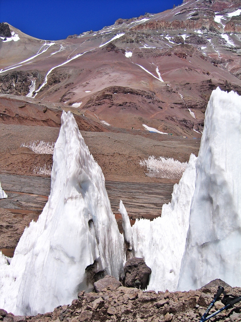


The next day was a group acclimatization trek to the Horcones Glacier. This glacier is mostly a large group of Nieve Penitentes rather than a typical glacier. We were supposed to be reviewing glacier travel but as there is no glacier on the Normal Route, nor crevasses or bergshrunds on Horcones, we instead enjoyed the day relaxing beside these unusual formations.
Plaza de Mulas to Camp Alaska
Gain – 791 m, Trekking time – 4 hrs
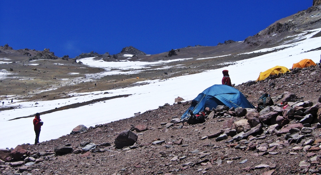
The trail from basecamp to Camp Alaska doesn’t change much in terms of scenery. It’s a long slow grind up the steep scree slope above Plaza de Mulas, passing the previous spot Maggie and I reached 2 days earlier. I didn’t hire a porter and there are no mules beyond basecamp. This meant that I carried my own gear and my share of the camp gear to the high camps. I was thankful for the benefit I gained on the previous days’ acclimatization treks.
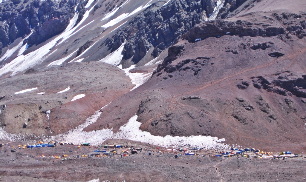
As with all of the high camps on the mountain, Camp Alaska (5180 m, 16,995 ft) is set on an open area with little protection from the cold wind. While we were setting up our tent a strong gust of wind blew in and picked up the tent. Remarkably it blew up the mountain, toward the summit, and not downhill. I ran after it, but at over 5000 m I was exhausted after only 10 strides and had to stop. Luckily another expedition was above us and were able to catch the tent. Lesson learned. Put stones or equipment inside the tent right away.
Even though its not a difficult climb by mountaineering standards, only 30-40% of climbers actually summit. This is most likely because many climbers underestimate the mountain and overestimate their fitness and their ability to acclimatize. This so called ‘easy trail’ is at very high elevations with extremely cold temperatures.
One member of our team had been exhibiting symptoms of altitude sickness for the last few days. He was extremely fit, but his body could not acclimatize. Today he was climbing very slow. It was after dark when he finally arrived at Camp Alaska and he was sick all night. By the morning he decided his journey was over. He returned to basecamp that day.

Camp Alaska to Camp Berlin
Gain – 600 m, Trekking time – 6 hrs
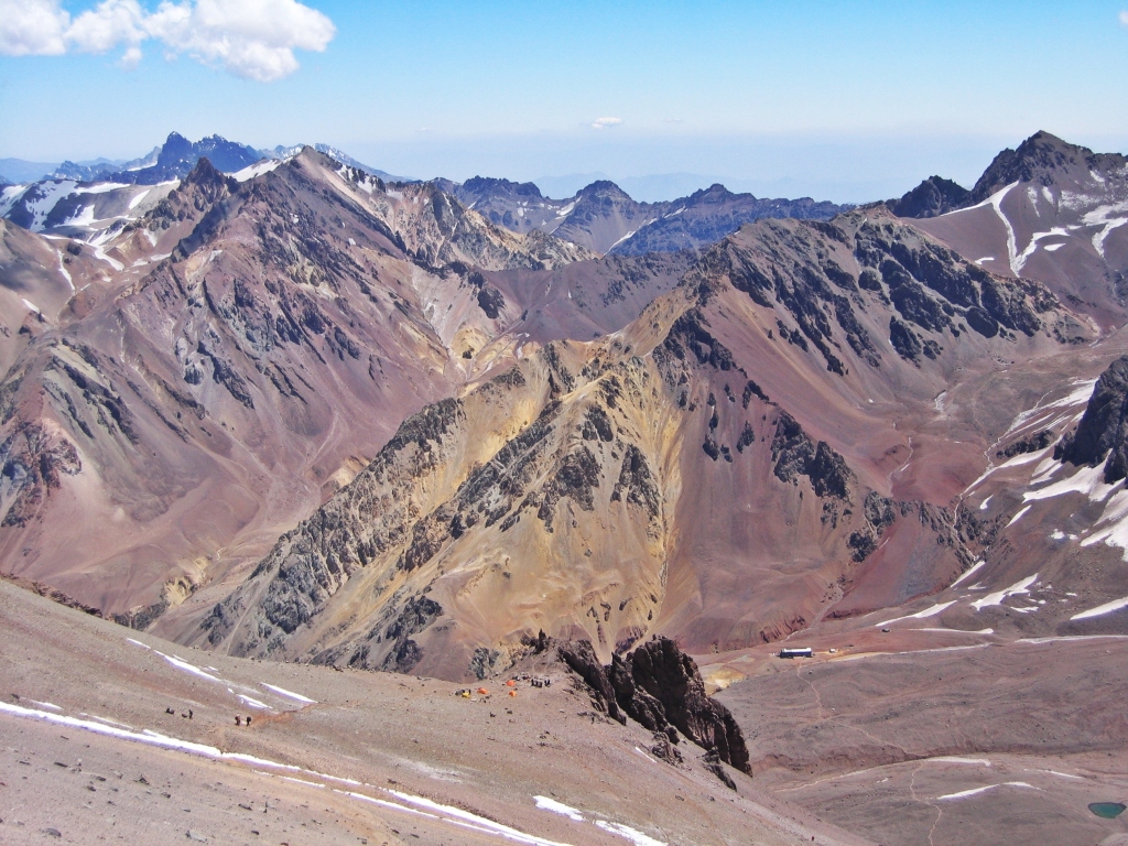
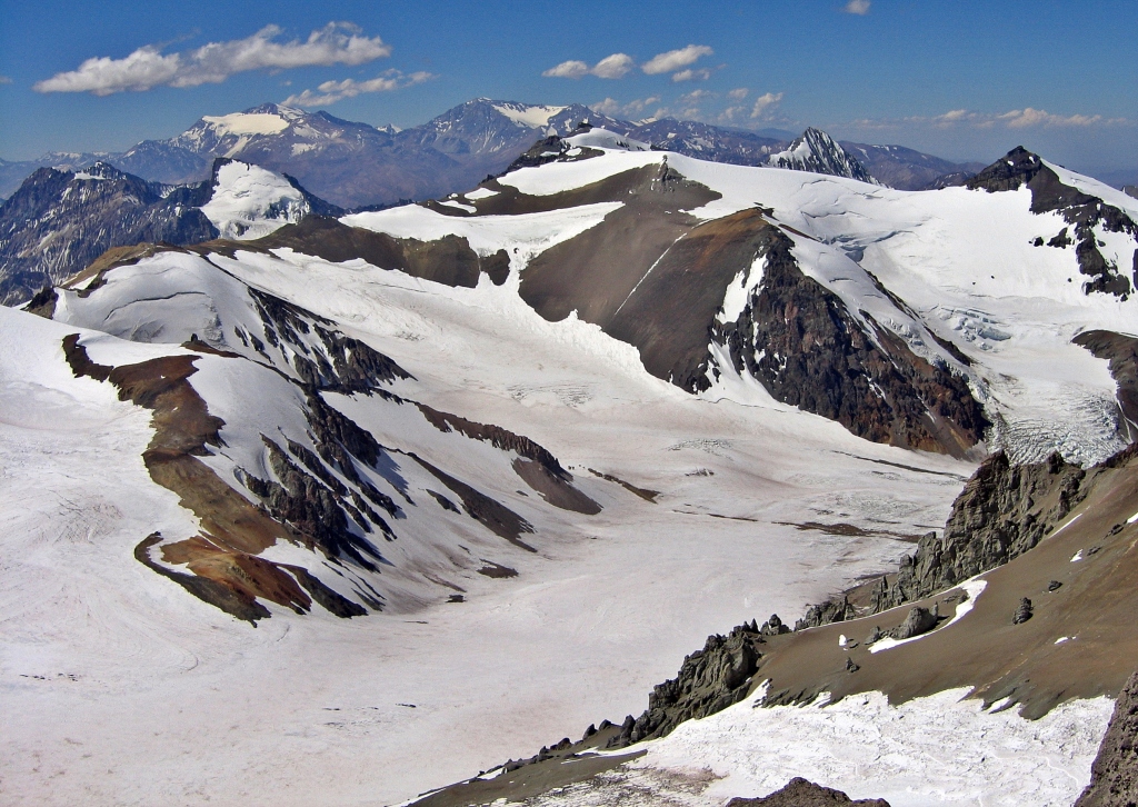
Continuing up the trail above Camp Alaska we started to have great views of the trail to the summit. You can see in the picture below how it follows along the scree slope passing under the summit before crossing back up the steep gully called canaleta to reach the summit.


We passed Camp Nido de Condores (5560m), the condors nest. Some climbing expeditions stay here but we continued going up. Following switchbacks up the same brown slope we finally arrived at Camp Berlin (5780 m, 18,963 ft).


Having carried a full pack to Camp Berlin and then setting up a tent, I was completely exhausted. I sat down with two other climbers and had an out of body experience. It was as if another person was saying my words. My mind and body felt disconnected. After 5 minutes of rest and catching up on my extreme oxygen debt, I stopped hallucinating and my senses returned to normal. It was scary for those few minutes, unsure if I would return to normal or if this was then end of my climb. Another reminder, everything at altitude must be done slowly, with many breaks. Another member of our team was struggling much worse than me and didn’t proceed any further.
Summit day – Camp Berlin to Summit
Gain – 1180 m, Trekking time – 7 hrs
We woke early and left camp by 5 am. The trail continued to climb in a series of switchbacks on the brown slope. It was a steady climb with no reprieve. As we climbed higher and higher we had more amazing views of the Horcones valley and the surrounding Andean mountains. Climbing at this intensity and altitude I find it helpful to set little goals. As I passed Independencia Refuge I was elated as I knew I had achieved one of the small goals.
Now I was on the final stages to the summit. Step after step, in a monotonous rhythm. I reached another goal, the base of the canaleta (gutter). Climbing the loose scree in this gully can be very challenging later in the day. It’s easier if there is snow or the ground is frozen. If not, the climb feels like 2 steps forward and one step back. I sat and rested for 15 minutes before attempting this last challenge. Another member from our team came for a stop there too. After the rest I got up to continue, but he turned back, realising he couldn’t make it any higher. It must have been difficult to come to this decision, but for him, it was the smart thing to do.


Mountaineering has always been an important part of my life. After an easy hike to the top of Mount Kosciuszko in Australia, I realized that I had made it to the top of one of the Seven Summits. This seemed like a worthy goal and so from that day in Australia I vowed to myself to complete the Seven Summits. Aconcagua would be the highest I had ever been. At 6,962 m, it was almost 2,000 m higher than my previous high of Mount Blanc.
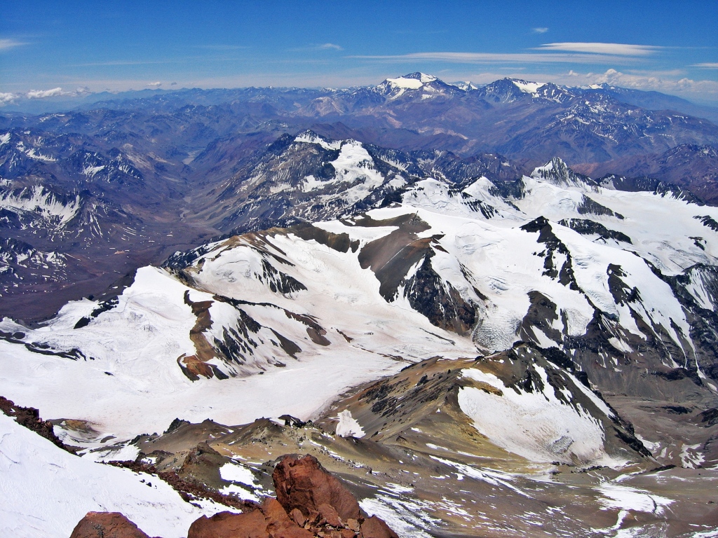
Reaching the summit ridge I knew I was getting close. I followed its steady rise until finally I’d arrived on the huge flat summit of Aconcagua. The summit is surprisingly large, about twice the size of a hockey rink. I walked over to the edge of the summit, above a steep drop-off and stared in awe at the view. I was elated to have made it. 6,962 m. The highest I’d ever been…yet.


The Descent
Descending feels incredible. Each step leads to more oxygen and you feel better and better, gaining more and more energy. We had one more night at Camp Berlin and the next night we enjoyed a celebratory dinner at Plaza de Mulas.
After a long walk down from basecamp, we visited the memorial for fallen climbers near the park gates. It’s difficult but important to our pay respects. When we finally arrived at the park gates we were told our transportation would be late. We sat on the ground, exhausted and waited for our ride. After a while a group of American hikers stopped by and asked us about the climb. Their car arrived shortly after and since we were still waiting they left us a bottle of Johnny Walker. By the time our van arrived, over 2 hours later, we were all in a pretty good mood.

When to climb
You can climb Mt Aconcagua from mid November to mid February however, the best climbing conditions are between December and the end of January.
Do I need a permit to climb?
All climbers must buy a permit in Mendoza at the Aconcagua Provincial Park office. If you use a guiding company, they will arrange these permits.
Do I need a guide?
You do not need a guide to climb Aconcagua, but it is highly recommended. Guides provide the necessary provisions and logistics as well as an in-depth knowledge of the mountain, conditions and rescue operations.
To read other Seven Summit adventures click on the links: Carstenz Pyramid, Vinson Massif
Here’s a video of the climb:
Coming Next: Trekking in the Argentina’s Patagonia
For extra pictures from Argentina click here. For pictures from other blogs go to Gallery at monkeystale.ca
To read about more of our adventures go to Destinations.
If you like what you read, please comment or share (with credit) using the links below.

Congratulations on what was a monumental climb!. Geat post. 😊🙏
LikeLiked by 1 person
Oops I meant to say, great post😊
LikeLiked by 1 person
Thank you Suzette!
LikeLiked by 1 person
Wow!! What an adventure. Thanks for sharing.
LikeLiked by 1 person
Thank you, glad you came along for the climb!
LikeLiked by 1 person
Well done. Both the climb and the views are breathtaking. Thanks for sharing. Allan
LikeLiked by 1 person
Thanks Allan, It’s incredible what you can see from so high up. Your perspective changes, from the height and the lack of oxygen! Thanks for reading.
LikeLiked by 1 person
Wow! Great post with magic pictures 😊👍👏.
LikeLiked by 1 person
Thank you so much! It’s a very colourful valley, more than expected.
LikeLike
Excellent. Congratulations on this achievement!
LikeLiked by 1 person
Thank you!!
LikeLike
Incredible achievement and magnificent account of all this with some marvelous photographs.Congratulations! It was a fascinating read.
LikeLiked by 1 person
Thank you, glad you enjoyed the climb!
LikeLike
So beautiful! Thank you for writing this.
LikeLiked by 1 person
Thank you so much, we really appreciate your kind words.
LikeLike
Incredible. Great post!
LikeLiked by 1 person
Thank you!!
LikeLike
Amazing scenery with all the colours and features especially the ice formations. What an incredible adventure and achievement! On to the next of the seven!
LikeLike
Thanks Francis! This climb had so much unexpected beauty. We were told it was the ugliest mountain, but it was so colourful. Hope you’re well. Maggie
LikeLike
I am very impressed by the performance but also by the diversity and quality of the images. It’s like another performance to have retained enough lucidity despite the effort. Many thanks for this interesting report.
LikeLiked by 1 person
Thank you, It’s true, it’s difficult to remember to take pictures when your mind is so focused and your body is so drained of energy. But it’s such a beautiful area, that I’m glad I was able to capture it.
LikeLiked by 1 person
Beautiful photos. I worked at Prescott College for awhile, a college known as one of the first offering environmental education. One of the students was singing the praises of high altitude climbing and how you struggle to breathe. I laughed as I grew up with severe asthma, in and out of ER’s and hospitals, often spending many days struggling to breathe, barely leaning up against a wall, with and without drugs pumping into me. So I didn’t need to climb at high altitudes to experience that feeling, although my life has been a series of that feeling of attempting to climb the highest peak and all the effort it takes.
Glad you can reach out and fulfill your dreams.
LikeLiked by 1 person
Thank you Katelon, I (Maggie) also have asthma, although mild. Breathing at altitude is nothing like an asthma attack, it’s more like being very out of shape, even when you try to do the easiest task. And often you don’t know that you’re having problems breathing right away, until you get dizzy, breathing heavy etc. Asthma is obviously much worse and I think if they were similar, people wouldn’t go to altitude. Hope you stay healthy, especially now with this respiratory virus.
LikeLiked by 1 person
Breathtaking photos and wonderful account. I shared this with my son and I think he’s making a plan.
LikeLiked by 1 person
That’s awesome! Tell him he can contact us if he has any questions about it. Thanks!!
LikeLike
WOW! That’s incredible! Congratulations. Lovely photos! 😍
LikeLiked by 1 person
Thank you!!
LikeLike
Stunning – the place and the climb. And quite scary. That out of body moment. And the elation you must have felt on getting there. Wow!
LikeLiked by 1 person
Thank you, The area is much more beautiful than we expected. The climb was also tougher than expected and yes very rewarding to have made it, especially seeing so many others turn back.
LikeLike
Kudos! What an accomplishment! Those ice spires are fascinating. As Seinfeld’s Kramer says, “Mother Nature’s a mad scientist.”
LikeLiked by 1 person
Haha indeed she is! Thanks!!
LikeLiked by 1 person
Wonderful. I haven’t seen ice spires in the Himalayas. That probably takes very special condition; or maybe they are at heights I haven’t been to.
LikeLiked by 1 person
We have a seen a few in the Himalayas but it’s usually one or two. In the Andes there are hundreds grouped together. It looks very interesting and unlike anything else.
LikeLiked by 1 person
Now that’s the spirit! (See what I did there… Johnny Walker end.) Really enjoyed the perspective shots with people in them. So much beauty in this big world.
LikeLiked by 1 person
Haha! Thank you. We usually don’t like people in our pictures but you’re right, it helps with perspective. Thanks for reading😊
LikeLiked by 1 person
Congrats for this new achievement! The views are mesmerizing from the top!
This Johnny, he is such a big walker🙂
LikeLiked by 1 person
Thanks Christie, it’s a good thing we didn’t meet Johnny on the way up!
LikeLiked by 1 person
🙂🙂🙂
LikeLike
Congratulations Richard! Your exciting narrative and stunning photos had me feeling like I was with you (thankfully from the safety of my sea level perch). The scenery is stunning. The colourful mineral striped mountains remind me of Hornocal in northern Argentina. That’s at 4350 m and I could feel the altitude just walking a short distance. I’m glad that your scary symptoms were short-lived. Those ice spires are extraordinary…good that Maggie is in one of the photos for perspective. My favourite photo is the one taken above Alaska Camp with the ice spires in the foreground. Great post; thank you for the exciting read.
LikeLiked by 1 person
Thank you Caroline, The area was much more beautiful than expected. So many colours. We love that picture from above Camp Alaska as well. We just looked up Hornocal and the mountains there look amazing, so colourful. We’ll have to add that on our list for a future trip!
LikeLiked by 1 person
Hornocal and the whole area in northern Argentina’s Salta and Jujuy provinces is interesting and dramatic. I wrote a few blog posts on them if you ever want info for a future trip. I look forward to your posts about trekking in Argentinian Patagonia. I’m sure they are more adventures than ours but those day hikes we did from El Chalten had some of the best scenery I’ve ever witnessed, especially with the fall colours.
LikeLiked by 1 person
Great I’ll look for those posts. Looking at our pictures from the El Chalten area now and we had such awful weather, so many clouds, but we’ll see how it turns out.
LikeLiked by 1 person
Congratulations Richard! Every word reminds me of all the mountain climbs I’ve done so far, although none of them was as hard and arduous as Aconcagua, for sure. This is such a huge accomplishment! I remember you’ve been to Puncak Jaya as well. How many more summits to go for you to complete all the Seven Summits?
LikeLiked by 1 person
Thanks Bama, Mountaineering takes you to unbelievable places doesn’t it? I’ve actually completed the Seven Summits, we’re just slowly releasing the stories.
LikeLiked by 1 person
Whoaaa that’s awesome!!! I can’t wait to read the rest of the stories!
LikeLiked by 1 person
We also posted the climb on Vinson Massif on Antarctica.
LikeLiked by 1 person
I’m looking it up right now.
LikeLiked by 1 person
Amazing! I’ve always had the goal to summit Aconcagua someday. I know I’m not there yet but this makes me very excited to someday attempt this hike. Those photos are stunning, I never knew it was so colorful and those snow formations are unlike anything I’ve ever seen before. Thanks for sharing!
LikeLiked by 1 person
Thanks Diana, it’s not that difficult, but you need to take your time to acclimatize properly. It is a great climb with much better scenery than we expected. The penitentes were strange and wonderful features that we had never seen before either.
LikeLiked by 1 person
I don’t think I would ever make this expedition in a million years, so thanks for giving readers like me the opportunity to experience it virtually.
Also: The red colour of that Alpenglow! I gasped out loud when I saw that photo.
LikeLiked by 1 person
Glad you enjoyed the trek with us! Yes, the alpenglow picture proudly hangs on our wall, we love it too.
LikeLike
Wow! Took my breath away. I’ve never been good with adjusting to high altitude (lack of oxygen) and that makes me appreciate your climb all the more. It’s quite an achievement. Stunning photography! Your post is a silver lining in the times we live in!
LikeLiked by 1 person
Thank you, It was a great feeling to have accomplished it. We decided to continue with previous our travel adventures rather than add to the massive amounts of coronavirus posts.
LikeLiked by 1 person
Congrats on the climb. I would love to hike this one day. The views look stunning.
LikeLiked by 1 person
Thank you, it’s beauty is in the colours rather than the usual trees and lakes. Some people don’t like it, but we could see it’s beauty.
LikeLiked by 1 person
What an incredible adventure and feat! The views are breathtaking! ❤
LikeLiked by 1 person
Thank you Donna, It is an incredible area.
LikeLiked by 1 person
Impressive and truly stunning! Thank you for the inspiration ❤
LikeLiked by 1 person
Thank you.
LikeLike
Hi guys! I have nominated you for the Real Neat Blog Award! You can check it out in my article, just published. https://leightontravels.com/category/real-neat-blog-award/
LikeLiked by 1 person
Thank you very much Leighton! We have a couple other awards too, so I’ll probably try to combine them in one post soon. Congratulations!!
LikeLiked by 1 person
You are a god and I’m in awe of your strength and determination!
LikeLiked by 1 person
Thank you, it depends on what you’re used to I suppose. Climbing mountains is a part of our life.
LikeLike
This is amazing, what a great accomplishment!
LikeLiked by 1 person
Thank you Virginia!
LikeLike
Pretty nice post. I just stumbled upon your blog and wanted to say that I’ve truly enjoyed browsing your blog posts. In any case I will be subscribing to your rss feed and I hope you write again very soon!
LikeLike