
Patagonia has harsh, unpredictable weather, but it only seems to add to its spectacular rugged landscapes. Before climbing Aconcagua, we went on a hiking trip to Patagonia in both Argentina and Chile. Parque Nacional Torres del Paine in Chile is one of the most popular trekking destinations in this region, and after you see these views, you will understand why.
O Circuit Route
The most popular trekking route in the park is the W Route. The less popular, more rugged way to explore the park is to do the whole loop that encircles the centre massif. Of course we decided to do the loop. The O Circuit goes through a wild and remote backcountry before joining the popular W Route to complete the circuit.

It’s a 2 1/2 hour drive from Puerto Natales so its easy to begin hiking on the same day. As we neared the entrance of Parque Nacional Torres del Paine, the amazing mountainscapes started to appear. Tall snow-capped peaks stood high across the grassy hills. A flock of Lesser Rheas, a Patagonian emu, ran beside the road. When we got off the bus at Guarderia Laguna Amarga we saw guanacos near the river. This was going to be a great hike.

Approaching Parque Nacional Torres del Paine 
Lesser Rheas, Torres del Paine 
Guanacos, Parque Nacional Torres del Paine
The trail circumnavigates Macizo Paine (Paine Massif) in a counterclockwise direction. It begins from the park gates and follows the Rio Paine (Blue River). We climbed up and over hills covered in unusual brush, trees and flowers. The clouds hung low so we couldn’t see much in any direction and it rained for the first two days.

O Circuit Trek, Parque Nacional Torres del Paine 
O Circuit trek, Parque Nacional Torres del Paine 
Vegetation, Parque Nacional Torres del Paine 
O Circuit trek, Parque Nacional Torres del Paine 
Rio Paine, Parque Nacional Torres del Paine 
Fire Tree, Parque Nacional Torres del Paine
The Route is an undulating trail for much of it’s length. We would hike up 200 m, down 200 m, up 300 m down 100 m. After several hours of trekking this tiresome route over two days we finally had a great view. Lago Dickson is a large, quiet lake, only disturbed by the ice calving off its glacier. You can see icebergs floating on the lake in the pictures below.

Lago Dickson, Parque Nacional Torres del Paine 
Lago Dickson, Parque Nacional Torres del Paine 
Lago Dickson, Parque Nacional Torres del Paine
The next day was the most difficult and least pleasant. We began the day by following the wild Rio de los Perros (River of the Dogs). The legend says that the river received its name after a shepherd’s dogs drown in the fast-moving river. As we crossed the rushing river on a rickety suspension bridge, we hoped not to prove the legend correct.
Shortly after the bridge, the trail went through a large peat bog. There was no where to put your foot without sinking into the spongy, muddy ground. We attempted several ways to avoid it but each attempt landed us in a worse situation.

O Circuit trek, Parque Nacional Torres del Paine 
Rio de los Perros, Parque Nacional Torres del Paine 
Flowers, Parque Nacional Torres del Paine
Finally we were on the other side of the bog, but our feet were soaked. We began to ascend through a sparse lenga forest. The skies were better today and we could see the tall peaks all around and glacier lakes below. It’s a long slow grind up rocky slopes and moraine ridge to reach Paso John Garner (1180 m). The barren pass is notorious for having very strong winds and today was no different. Even after all of our effort getting to it, the winds meant we didn’t stay long. From the pass we had a quick look at the impressive Glacier Grey (Ventisquero Grey) before descending through the trees.

O Circuit trek, Parque Nacional Torres del Paine 
Trek to Paso John Garner, Parque Nacional Torres del Paine 
Look towards Laguna de los Perros, Parque Nacional Torres del Paine 
Paso John Garner, Parque Nacional Torres del Paine 
Glacier Grey, Parque Nacional Torres del Paine
The hike went down between tightly spaced lenga trees which were twisted from the constant strong winds. This was one of the most treacherous parts of the hike. Since it had been raining, the trail was very muddy. To make it worse, the trail went from being steep, to going almost straight downhill. We had to grab onto tree limbs with both hands to prevent us from sliding all the way down.
Glacier Grey is a massive ice field. We thought we were able to see most of it from the pass. As we hiked down, we realized we had only seen a fraction of the ice sheet. A large rocky island was blocking our view of the other side. From above, we could see huge sections of the glacier calving into the lake. It’s very windy in this area and these icebergs were being blown across the lake before landing on the opposite shore. Arriving at the Glacier Grey lookout we had joined the W Route. Things were sure to get easier.

Lago Grey, Parque Nacional Torres del Paine 
Glacier Grey, Parque Nacional Torres del Paine 
Glacier and Lago Grey, Parque Nacional Torres del Paine 
Laguna Parque Nacional Torres del Paine
Finally at the bottom of the hill we had incredible views of Cuernos del Paine behind Lago Pehoe. Its majestic granite spires and distinctive black shale horns (cuernos) are breathtaking. This is one of the views we had been expectantly waiting for.

Fire tree and Cuernos del Paine from Lago Pehoe 
Cuernos del Paine from Lago Pehoe 
Cuernos del Paine from Lago Pehoe
The next highly anticipated stop was Mirador Cuernos del Paine. The trail first travels through low bush, allowing us to have a close up view of Cuernos del Paine. Then it’s a steep hike up moraine and boulder fields for a view of the mountain’s shear granite walls beneath the unmistakable black horns. On the other side of the narrow valley are the tall imposing granite spires of Cerro Paine Grande. Looking back down the Frances River Valley the beautiful blue water of Lago Nordenskjold completed the scene.

Cuernos del Paine 
Cuernos del Paine from the Mirador 
Cerro Paine Grande from Mirador 
View from Mirador Cuernos del Paine 
Lago Nordenskjold
The Curenos still towered above us as we continued on the W Route, skirting the side of Lago Nordenskjold. The wind was very intense. It was so fierce that it blew water across the lake and onto us. It was like horizontal rain!
The hike was long today with much climbing up and down as the trail crossed many side gorges. Finally, we could see in the distance the most famous peaks in the park. The tall, imposing spires of Torres del Paine stood proudly above the grassy fields. It was a prelude to our views the next day.

Cuernos del Paine 
View from Lago Nordenskjold 
View of Torres del Paine
Trek details – The O Circuit Route takes 6 to 10 days and covers approximately 135 km. There is a lot of elevation gain and loss everyday on the constantly undulating trail. The trails are well marked and easy to follow.
Torres del Paine Lookout
The next day we woke to a cloudy sky. It was disheartening since it was our only day to go to the Torres del Paine lookout. We hoped the skies would clear. The trail begins easy, passing green hills covered in Patagonia heather. As we got higher, it began to get more steep as we scaled the moraine until finally arriving the at boulder field in front of Torres del Paine. Shear walls of granite form a tight pack as if protecting a small glacier lake. Even on a cloudy, windy day, the towers are very impressive.
Trek details – Torres del Paine Lookout Trek is a part of the W Route, but can also be done as a day hike. It will take approximately 5 – 6 hours return from Las Torres Campground, or 9 – 10 hour return from the park gates at Guarderia Laguna Amarga, The trail is well marked and easy to follow.

Torres del Paine 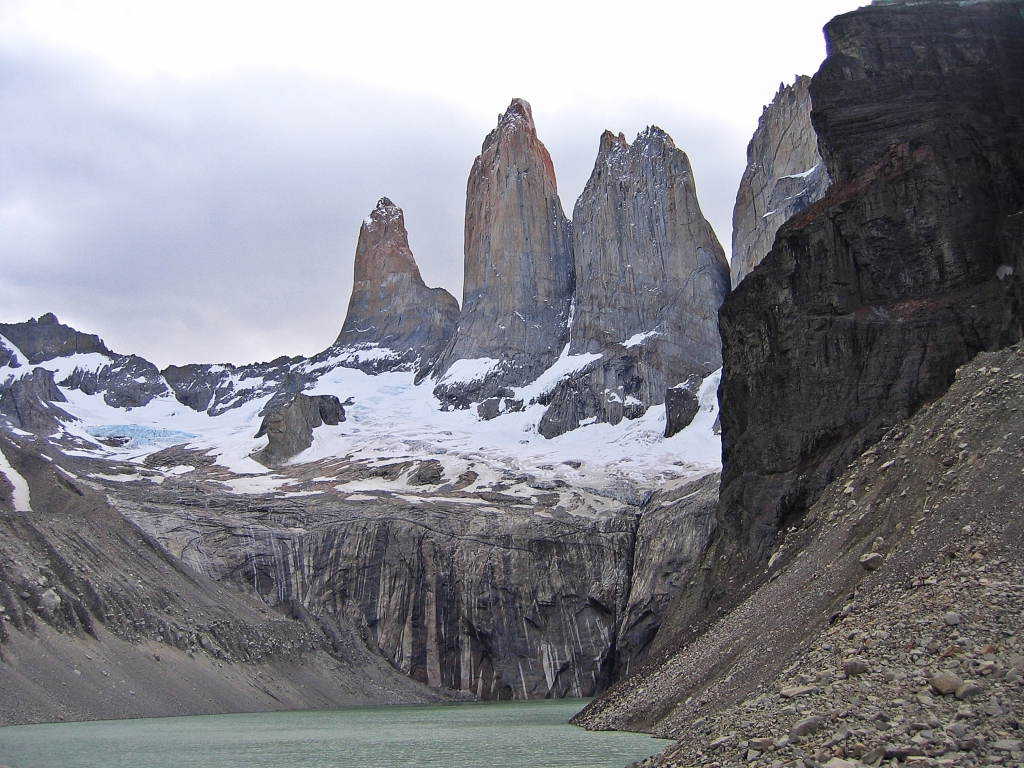
Torres del Paine
Lago Nordenskjold Cuernos lookout
For our final day in Torres del Paine we went for one last look at our favourite Cuernos del Paine. A bus took us to Guardaria Lago Pehoe. From there it was a short hike over grassy hills with grazing guanacos to the side of Lago Nordenskjold. The spot had best views of the incredible Cuernos del Paine towering over the blue waters of the lake. It was the view we had been looking forward to for the entire trip.
Just off the trekking trail and surprisingly close to the road we found a marvelous waterfall, Salto Grande. What a great way to finish our time in Torres del Paine.

Guanacos, Torres del Paine 
Cuernos del Paine behind Lago Nordenskjold 
Cuernos del Paine and Lago Nordenskjold 
Salto Grande waterfall, Torres del Paine
Seno Otway (Otway Sound)
From Puerto Natales we visited the Magellanic penguins at Seno Otway Reservation. It is an amazing place. Over 60,000 penguins waddle around the sand dunes back and forth between their nests and the sea. It was a fun filled afternoon of penguin watching.

Magellanic penguin and nest, Otway Sound 
Magellanic penguin, Otway Sound 
Magellanic penguins, Otway Sound 
Skunks, Otway Sound
Getting to Parque Nacional Torres del Paine
By bus – Buses leave frequently from Puerto Natales for the different park entrances (2 ½ hours).
Park fees
Park fees are 25,000 CLP for adults with an addition fee of 35,000 CLP to stay more than 3 days. Tickets need to be paid in cash at the park gates, or by credit card at the bus station in Puerto Natales.
There are no ATMs in the park so bring enough cash for your entire stay.
Where to stay
Whether you’re doing the O or W Routes there are many campgrounds and refugios on the treks allowing you to chose how many days you want to spend. We brought our own meals, but even if you camp you can purchase meals at the refugios. Even though they are very rustic, refugio prices are quite high. Some campgrounds rent tents so you don’t have to carry one if you don’t want.
Note: As of October, 2016, you have to make reservations for all campsites and refugios that you intend to use. Therefore decide on your route and exact dates before you book. You need to carry a copy of your reservation with you on the trek.
When to trek
The summer trekking season runs from December until early March. It’s possible to trek in the spring and fall but it will be colder. We were there in December and the skies were usually covered in cloud. The O Route is closed between May 1 – Oct 31st.
Coming Next: Cusco & Arequipa – A Blend of Peru’s Inca and Colonial Heritage
For extra pictures from Chile click here. For pictures from other blogs go to Gallery at monkeystale.ca
To read about more of our adventures go to Destinations.
If you like what you read, please comment or share (with credit) using the links below.

Absolutely incredible landscapes and seascapes. Those mountains are beyond impressive.
Neil Scheinin
LikeLiked by 1 person
Thanks Neil, Patagonia is sill very wild and impressive.
LikeLiked by 1 person
Stunning! If the pictures are so beautiful I can just imagine what they must have been like in real. Lucky you, is all I can say. Experiences like these are truly priceless.
LikeLiked by 1 person
Thanks Rama, Patagonia is a special place. The views are spectacular even in bad weather.
LikeLike
Sounds a truly amazing hike, such variety and yet one constant; absolutely stunning scenery which, as ever, you’ve captured wonderfully! Great post!!
LikeLiked by 1 person
Thank you! Patagonia is an incredible place with amazing scenery. Thanks for all of your kind words. Maggie
LikeLiked by 1 person
This and last week’s post definitely show that!!
LikeLiked by 1 person
Apologies! Hit send by accident haha. Both posts really brought the place to life and a lot of that has to do with an engaging written style coupled with wonderful pics.
LikeLiked by 1 person
Thank you so much! You’re always very kind. By the way, I don’t even know your name!
LikeLiked by 1 person
You are more than welcome, Colin 😉
LikeLiked by 1 person
What an awesome journey! The landscapes are beautiful. I am wondering were there other folks on the trail? How busy is the park with hikers?
LikeLiked by 1 person
Thanks Roxanne, The O Route isn’t very busy, we only saw a couple of others on the trail. Once we got to the front side, there were more people, but we often didn’t see anyone until the campsites each night. It was at the beginning of the summer season, so it wasn’t as busy as mid season. I think during mid summer the W Route is very busy.
LikeLiked by 1 person
Great post 😁
LikeLiked by 1 person
Thank you!
LikeLike
Wow!!!! What an amazing adventure!!!!!
LikeLiked by 1 person
Thanks Stephanie, it was an exhausting, but great trip!
LikeLiked by 1 person
I totally get that, but not at that level!! Wow!!! What an exciting, physically challenging adventure!!!!! 😀😀😀
LikeLiked by 1 person
As usual an excellent article. Informative, detailed and great photos. I really need to get round to spending some time in this region one of these years.
LikeLiked by 1 person
Yes you should, Patagonia is incredible. It’s wild but has just the right amount of comforts to enjoy it. Thanks for reading! Maggie
LikeLiked by 1 person
Really enjoy your posts. Great gift in your writing taking the reader along the journey with you. I really appreciate that. Thank you very much. God’s peace to you.
LikeLiked by 1 person
Thank you so much Suzette, I’m glad you came with us on the trek! Stay safe, Maggie
LikeLiked by 1 person
This is serious hiking! Seeing the pictures the effort is worth it, this wilderness is really impressive. Thank you for this very lively post.
LikeLiked by 1 person
Thanks, yes Patagonia is unbelievable. The effort was worth it, especially reflecting back on it here in my warm house. Thanks for reading!
LikeLiked by 1 person
Great pictures although the weather was not nice 👍 😊👏.
LikeLiked by 1 person
Thanks, yes, we didn’t have nice skies for our whole trip. The weather in Patagonia is harsh isn’t it? But it’s so beautiful.
LikeLike
Breathtaking photography and fantastic post. Congratulations! Great info. We will save this. Thanks!
LikeLike
Thanks, it’s a little closer for you guys to go for a trip there. Patagonia is an untamed beauty.
LikeLiked by 1 person
Yes. It is a lot easier to get to from Colombia We plan on renting a camper van for 6-8 weeks in 2021.
Our friends at Above Us Only Sky did just that. It’s a great way to see a lot of Patagonia on both the Chile and Argentina side. They have a great blog site: https://www.aboveusonlyskies.com/
Your information is great. We will refer to it. Thanks!
LikeLiked by 2 people
Thanks, I’ll check out their blog.
LikeLike
Wonder whether there are any mountains in the world where you haven’t hiked!
LikeLiked by 1 person
haha, there are a few … but they’re on our list!
LikeLike
Such beautiful photos. It has been on the bucket list for so long – I wonder if The Fab Four would manage!
Thank you for sharing.
LikeLike
We did the “O” also! What a great trek that is, even when the conditions are not great (we never saw the torres – grrrr – and we found Los Perros camp and general area to be quite an ordeal also). But when the going was good, it was almost unparalleled in its views, and the balance of manageability with a decent challenge in some sections (that steep part after Grey Glacier and before the camp – eeeek!!) was a nice mix. Did you use the refugios and/or campsites? I can’t tell where you stopped each day; it seems like you covered way more ground than we did every day! We went from camps Seron to Dickson to Los Perros to Grey to Paine Grande to maybe Italiano or Britanico). Fun to see your photos and read your words about this great hike!
LikeLiked by 1 person
Thanks Lexi, it is an awesome hike in gorgeous wilderness isn’t it. We didn’t have much time so we did the trek quite quickly, 5 days I think. We’ve lost some of our pictures so that’s why some is missing. We camped, carrying our own tent and food, so it was challenging some days. The last day was a killer as we went from Pehoe to see the Cuernos and then to the final campsite at Las Torres. It’s great to look back at it now, and we’d actually like to do it again and hope for better weather!
LikeLiked by 1 person
What an adventure and beautiful photos! Any trouble with the altitude here?
LikeLiked by 2 people
Thank you, it’s a very gorgeous park. The highest point is 1180m and most of the trail is 300- 600 m elevation so it’s very low.
LikeLiked by 1 person
Stunning! Stunning photos
I love the rocks/cliffs. I love the glacier bed against the dark water and the bizzaro plants you highlight so often! Informative, as always, of course
What a crazy, beautiful place on which we all live!! Thanks for the reminder by capturing fragments of its glory.
LikeLiked by 2 people
Thank you so much Dawn! Patagonia is one of Mother Natures pure gems!
LikeLiked by 1 person
Absolutely amazing!
LikeLiked by 2 people
Thank you!!!
LikeLike
it looks absolutely brilliant! Wish I was fit enough to consider it! Must get fit so I can do this kind of thing again!
LikeLiked by 2 people
To do the full circuit fitness is important but the front-side W Route, is not too tough. Keep it in mind!
LikeLike
So strange to see penguins next to green grass!
That cloud behind Cuernos del Paine is amazing!
Beautiful photos, as always.
LikeLiked by 2 people
I know, they’re he lucky penguins! 😊
LikeLiked by 1 person
My feet are getting itchy! Looks amazing. What sort of altitude did you get up to, did make for a good acclimatization hike for Aconcagua or it mainly for the scenery?
LikeLiked by 1 person
Patagonia is very low. Most of the trek was between 300-600m with the highest being 1180m. It probably wasn’t the best thing to do before a high altitude climb 😊 We went for the scenery, you should definitely consider a hiking trip there. The colours in fall (March or so) are supposed to be amazing.
LikeLike
Looks like a wonderful experience and something I want to consider.
Seems only the Chilean Patagonia is available seeing that Argentina has closed their borders for so long
LikeLiked by 2 people
Thank you, Patagonia is incredible with such wild scenery. We did both hikes a couple of years ago, I’ve heard that Torres del Paine is completely closed right now too.
LikeLike
Ahhh, the fickle weather of Patagonia! At least you had enough clear breaks to see those magnificent spires. I may have mentioned this before but even though we both live near spectacular mountain ranges, Patagonia truly is a very different experience. Glacier Grey looks stunning and I love those big rounded mounds of vegetation with the orange flowers. Did you like this more than your Argentinian Patagonia experience? Having only been to Argentina, this really makes me want to return and see Torres del Paine.
LikeLiked by 3 people
I love the Canadian mountains, but you’re right, there’s something special about Patagonia. The mountains in Patagonia are so rugged and the horrible sky makes them seem more spectacular. It’s difficult to pick between the two parks. We had read so much about Cerro Torre that seeing it in person was surreal, so that will always be a special trip. In Torres del Paine we did the 6 – 10 day trek in 5 days and the weather was really awful for a lot of it so that took away from the enjoyment. The hiking in Torres del Paine has a lot of elevation gain and loss although you don’t actually gain elevation. Now looking back, I love the scenery in Torres and would like to go back! Two tips on Chile – they only drink instant coffee (for Mike) and everything is a lot more expensive than Argentina.
LikeLiked by 1 person
Thanks for the tips (Mike is especially appreciative learning about the coffee situation). Guess he’ll just have to drink more wine.
LikeLiked by 1 person
Always a good replacement!
LikeLiked by 1 person
At first I thought how come there are so many penguins deep inland? Then I searched and learnt about the peculiar geography of the Otway Inland Sound and it’s hydrological connection with the Straits of Magellan, which explained the Penguins.. ☺️☺️
Super brilliant article.. I must say it got me searching for Geography.. ☺️☺️ The trail is simply wonderful and it’s pleasing to see real Icy Fjords descending in the sea.. ☺️
Except for the risks associated with camping on the open air, I believe this trek is beautiful and worth trying atleast once in a lifetime.. ☺️
The granite peak is odd though and doesn’t look like a magmatic outpour.. Nor is it old enough to be a Magma plug.. Maybe the plate surface scrapping theory can explain it.. Need to do some research.. ☺️
Love articles like these which get me thinking into such intriguing avenues..☺️☺️
LikeLiked by 1 person
Yes, southern Patagonia has a convoluted shore with far reaching sounds. I am by no means knowledgeable about granite, but I believe it is a metamorphic rock so may begin as magma or sedimentary rock. A lot of the granite spires in Patagonia are similarly shaped. Glad we were able to pique your interest! You should definitely try to experience Patagonia’s wonder. Thanks so much for your comments.
LikeLike
You are welcome and thank you for sharing.. ☺️☺️
Yes, Patagonia has a lot of convoluted and deep inlets and inland sounds.
Granite is actually igneous rock, which means it’s a product of magma. It’s never sedimentary or metamorphic (marble is metamorphic).. May be the plate subduction and scrapping theory can explain the presence of granite spires in this zone.. Maybe I am wrong.. But that theory did explain the abnormal location of US Rocky Mountains (not Canadian Rocky Mountains) and the fact that such a Young Fold Mountain was actually granitic..
You are right.. These places should definitely be explored.. ☺️ Thank you for sharing.. ☺️
LikeLike
Ah such amazing sights and experience and the Magellanic penguin and the Lesser Rheas. Wow!
LikeLiked by 1 person
Patagonia is such an amazing place and still so wild. We loved seeing the penguins, and actually were able to get fairly close with the boardwalks that are set up. The Lesser Rheas were such a surprise. I had never heard of them and didn’t expect to see emu-like birds in Patagonia!
LikeLiked by 1 person
Ah, that’s lovely experience. 🙂
LikeLike
Patagonia looks absolutely breathtaking. You are so lucky to have witnessed its majestic landscape!
Thanks for sharing!
LikeLiked by 1 person
Yes, Patagonia is a wild and wonderful area, we love it. Thanks for your comments.
LikeLiked by 1 person
It must have been a fantastic experience to be alone with those towering peaks all around. Thanks for another virtual tour in these uncertain times!
LikeLiked by 1 person
The granite spires are stunning, even in the bad weather. It’s usually a popular tourist place, but either we went too early in the season or we were lucky, but you’re right, we had it almost all to ourselves!
LikeLiked by 1 person
This post wit your amazing photos brings back memories of my visit to Torres del Paine and Cave of the Milodon Monument. The visit was a detour from Punta Arenas and Estrecheo de Magallanes. Such beautiful country. I wish I had time for trekking.
LikeLiked by 1 person
Thanks, we love this part of South America. We didn’t spend much time at the Straits of Magellan, so we’ll have to change places for our next trips!
LikeLiked by 1 person
I loved doing the W Trek last year, this makes me want to go back and do the O!
LikeLiked by 1 person
It was a great trek, but it’s much more wild on the other side so make sure you have food, tent etc. I wouldn’t rely on the refugios as much as you can the W. It is gorgeous though and worth it. Thanks for reading!
LikeLike
Beautiful. Similar landscape to New Zealand. Amazing!
LikeLiked by 1 person
Patagonia has incredible landscape as does New Zealand.
LikeLiked by 1 person
Excellent post! I did the W hike in late 2017 and it remains my favorite hike of all time. Was great to see pictures from the O part of the hike.
LikeLiked by 1 person
Thanks, the W hits the best part of the hike so you didn’t miss a lot on the O.
LikeLike
Wow, that’s a beautiful place! I bet you had fun trekking there. Hope the pandemic could end soon so we can visit Patagonia.
LikeLiked by 1 person
Patagonia is amazing. I hope you get there. Thanks for reading!
LikeLike
Amazing places. So beautiful. They remind me of the south island of New Zealand to some extent.
LikeLiked by 1 person
Yes they are similar to NZ. Wild landscapes making unbelievable views.
LikeLike