
The Cordillera Blanca mountain range in Peru has an astounding 50 peaks that are 5,700 m or higher. Its name translates to White Range which refers to the surplus of breathtaking snow covered peaks in the region. At the core of this range is one of the most beautiful mountains in the world, Alpamayo. We trekked the Alpamayo Circuit which takes you around the mountain where we were rewarded with amazing views of this scenic mountain range.
Day 1 – Cashampampa to Hualcayan Pampa
9 km; Ascent – 250 m
Getting to the trek was an interesting journey on its own. It involved a local, crowded bus weaving up a winding mountain road. Then we had to take an even more crowded station-wagon to get us to the start of the trek. Among the other passengers in the car was a farmer with his chickens who were loudly clucking at each turn in the road.
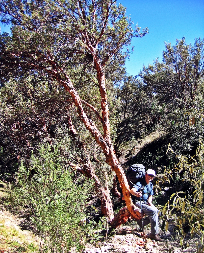
After squeezing out of the crammed station-wagon we were finally off to begin our trek. From the town of Cashampampa (2900 m) the trail is not the nicest as it follows a gravel road. Eventually though the road turns into a hiking trail. The first few hours are very hot, under the strong sun with no trees for shade. We climbed on the edge of a steep canyon with increasingly spectacular views. Finally, we arrived at our camping area called Hualcayan Pampa (3150m). We hadn’t seen anyone else for a long time and thought we were by ourselves, but out of nowhere a local boy appeared. He curiously watched us set up our tent and then was happy to show us where we could get water.

Day 2 – Hualcayan Pampa to Laguna Cullicocha
14km; Ascent 1450 m
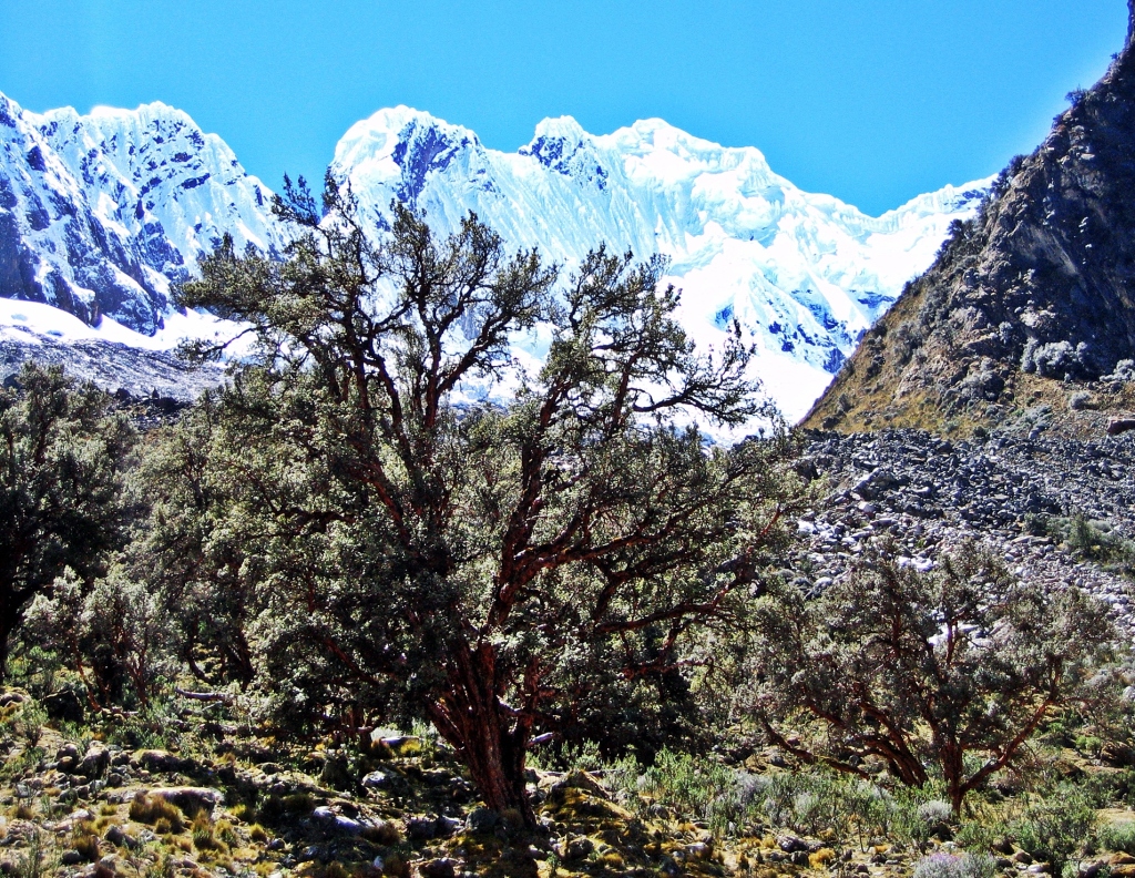
The next day began with a steep climb through a small forest of twisted quenua trees. Over the day we passed by gorgeous mountain lakes and enjoyed amazing views of the tall Cordillera Blanca mountains. After a few hours of climbing, we could see the pointed peak of the snow covered Nevado Santa Cruz high above. Beneath it would be our next campsite, but there was still a long hard climb up an unending number of switchbacks to get there.


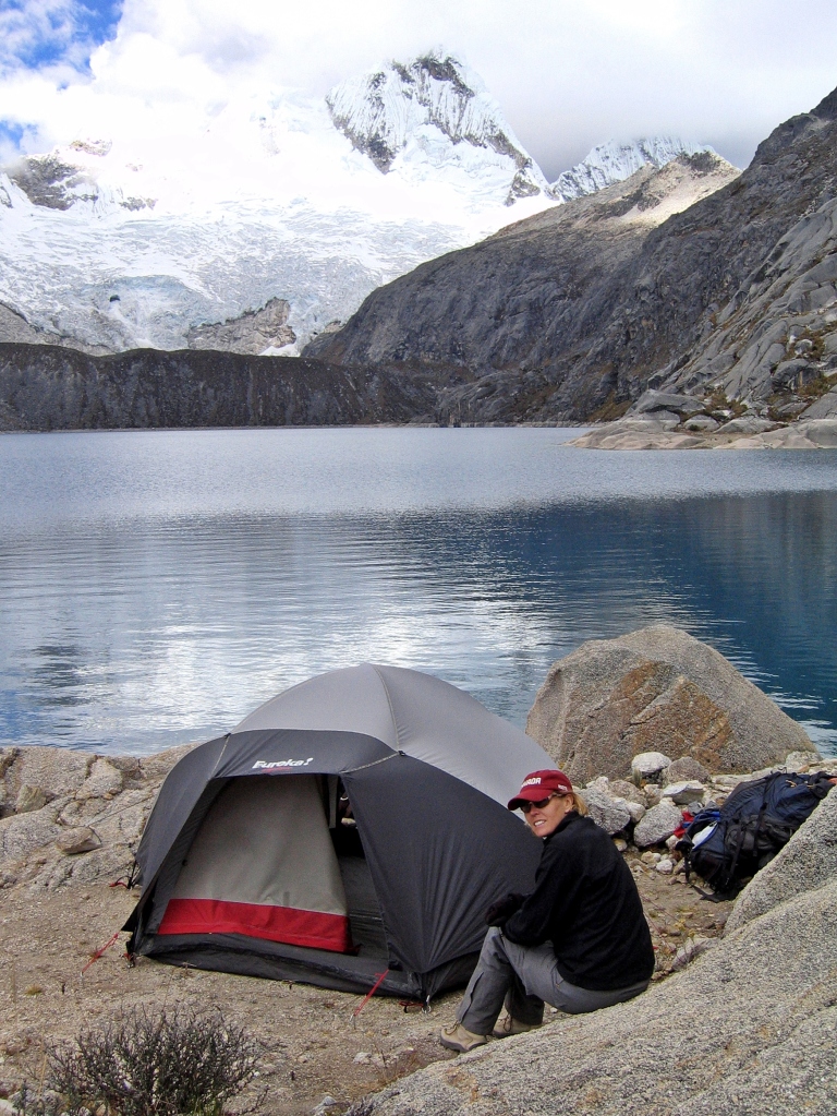
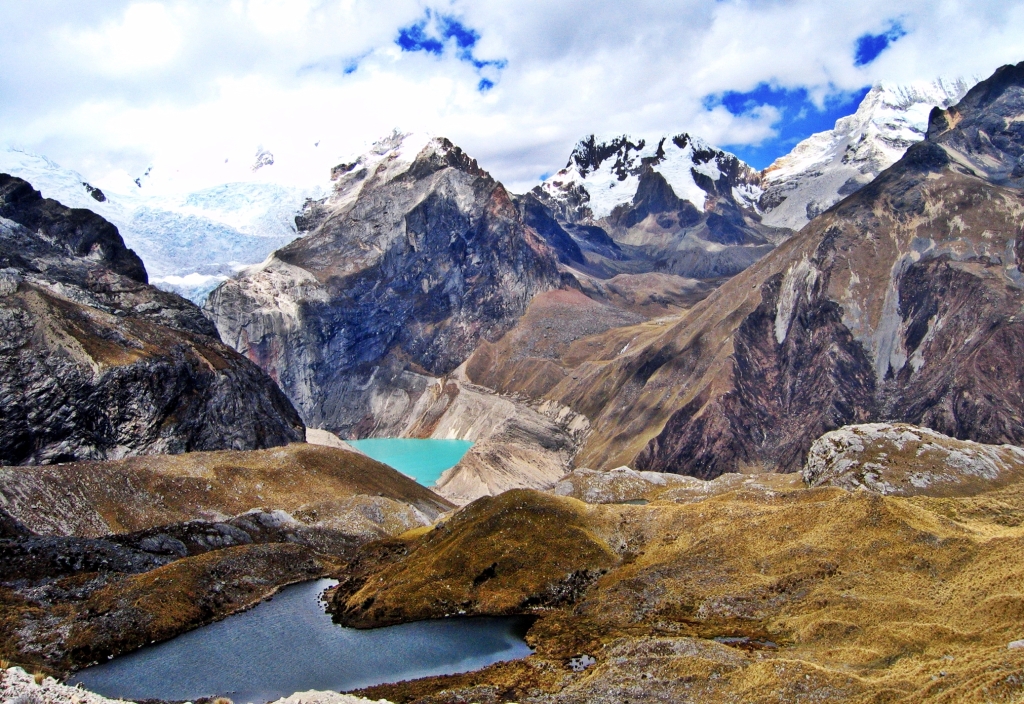
Our reward after 1400 meters of climbing was a night at one of the most beautiful campsites we have ever had. The view of Laguna Cullicocha (4600m) and the snowy Nevado Santa Cruz reflecting on its surface is stunning. We set up our tent on the side of the lake so we could enjoy the view.
At this campsite we realized that none of our three lighters had fuel! After much stress and searching, we were able to buy a box of matches from a muleteer for a dollar. These few matches needed to last for the next 7 days as there are no stores on the route.


Day 3 – Laguna Cullicocha to Quebrada Alpamayo
17 km; Ascent – 400 m, Descent – 600 m
The trail begins by climbing up the rocky landscape around the edge of the lake. We could see the tall white Andes all around. After the leaving Laguna Cullicocha we had to climb up and over 2 high passes. The first one, Paso Cullicocha (4850M), is the highest point on the trek. With full backpacks, it was a tough slog climbing up it and then over the smaller Paso los Cedros (4750M). The views from the passes were amazing though. Tall, snow covered Andes, crystal clear mountain lakes, what more can you ask?


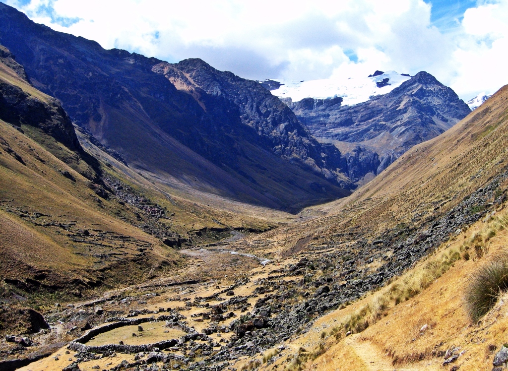
The descent was much easier, a gentle climb down into the valley. We passed a few scattered farm homes on our way down. These farms are very remote, only accessed by foot or mule. At the base of second pass is an Inca ruin called Ruina Pampa. It made us realize how far the Inca Empire spread. You can camp at the ruins or almost anywhere along Quebrada Alpamayo (Valley). We walked almost to the end of the valley and stayed at Juncarurish Camp (4210m) which is at the junction of a side trip to Alpamayo basecamp. We would go to basecamp the next day and were excited to see the famous mountain.
Day 4 – Quebrada Alpamayo to Alpamaya basecamp to Caracara
5 km; Ascent 450m to basecamp, then 15 km; Ascent – 620 m to below Caracara
From our campsite, it’s a steep climb up switchbacks to gain the open meadow above. We left camp early in the morning to get to basecamp in time to see the sunrise over the pointed peak of Alpamayo. It’s this gorgeous view of the perfect pyramid that gained it the title of the most beautiful mountain in the world by a German surveyor in the 1960s. Today, it’s still considered one of the top three beautiful mountains with Ama Dablam and Cerro Torre.
Our plan was stay at the Alpamayo north basecamp. When we were there, however, the ground was very boggy and we couldn’t find a spot for our tent.


After giving up the idea of camping, we headed back to the main trail. From here, the trail again climbs up a steep, narrow path passing several stunning turquoise alpine lakes. After a 2 hour climb we reached Caracara Pass (4830 m). Looking back we had a last view of Alpamayo’s pointed peak. Beyond this pass, the trail is very steep descent, but then flattens out where we were very glad to find a camp spot for the night.


Day 5 – Caracara to Janca Pampa
16 km; Ascent – 800 m, Descent – 1600 m
The next morning began with another steep, but shorter climb to Mesapampa Pass (4460 m). Near the top of the grassy pass, we had to veer around a herd of grazing cows. It was very unusual to see cows at almost 4500 m!
After descending from the pass we passed the small village of Huillca. Its actually only 4 or 5 farmhouses but is called a village. Soon after we had to go up another mountain pass. It’s a steep, rocky trail that leads to Paso Huillca (4610 m) but it’s worth it for the incredible views of the dramatic, rocky landscapes.
The final descent to Janca Pampa (3400m) was through a dense forest of gnarly quenua trees. As often happens in the mountains, the weather was changing quickly. We set up our tent at the head of the Janca Pampa Valley and by the time we were done we were enveloped in clouds.


Day 6 – Janca Pampa to Laguna Huecrucocha
15 km; Ascent – 1000 m
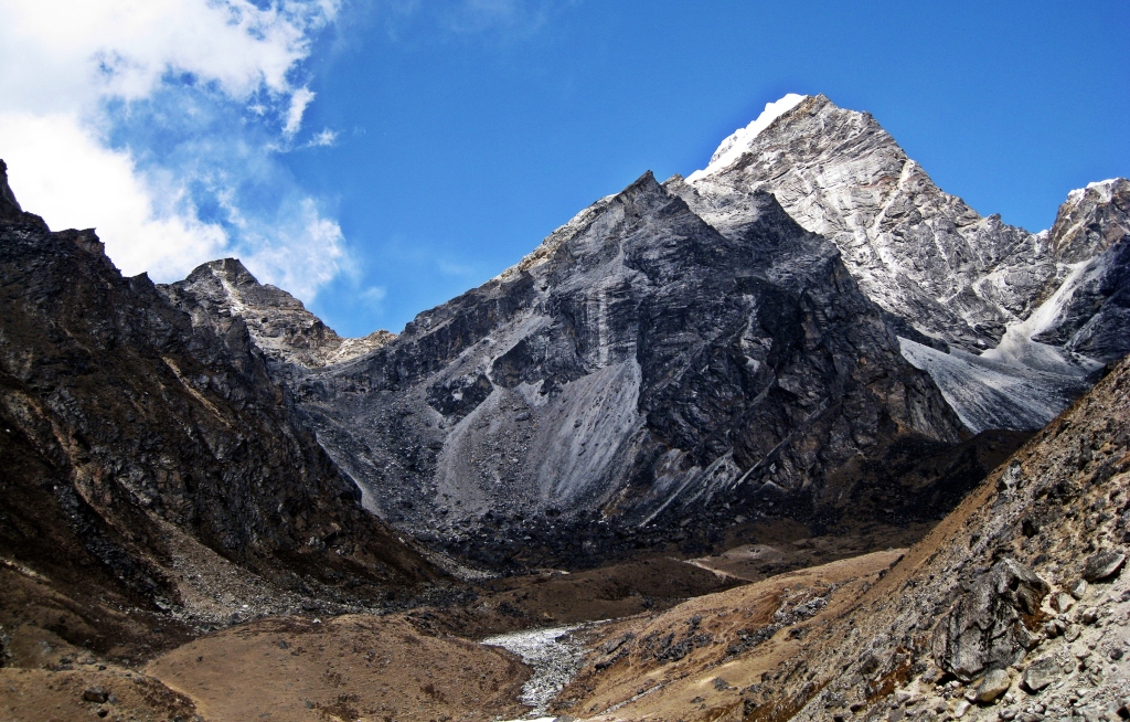
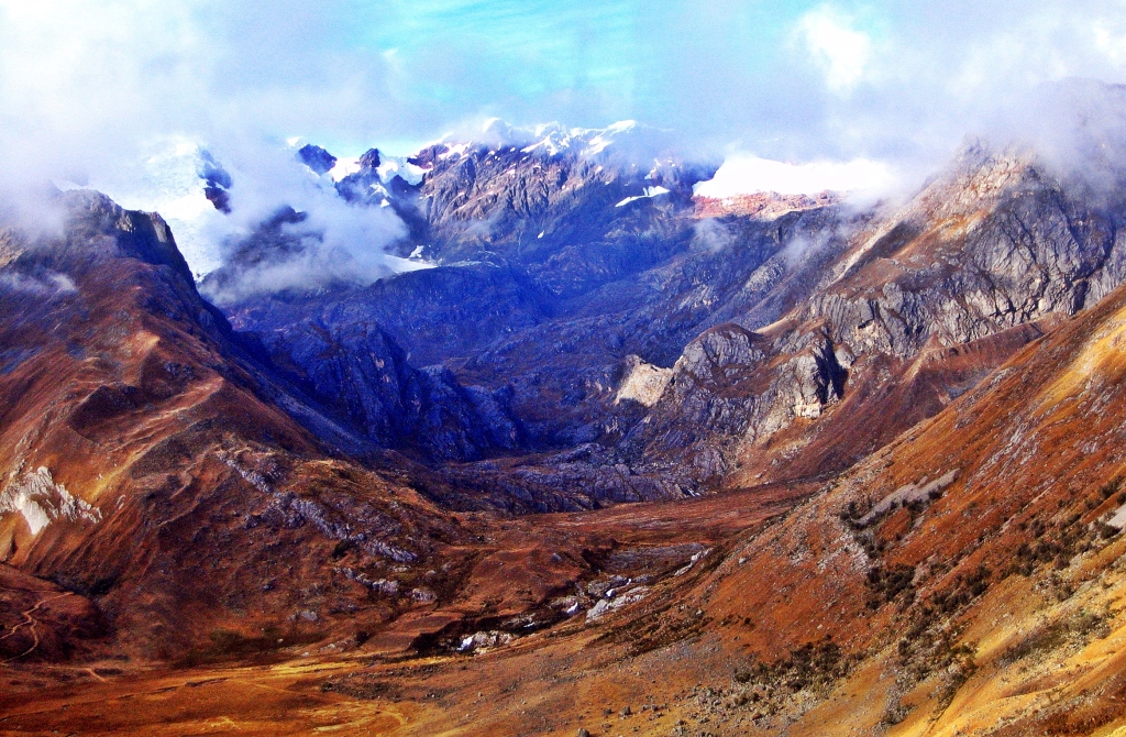
The next morning we were able to see the incredible views around us. At the end of the valley we saw the impressive Nevado Pucajirca and its large hanging glacier.
As we walked across the valley we passed a few farmhouses. Kids saw us coming and ran to us yelling ‘caramelo, caramelo’. We probably shouldn’t have, but we gave each of them a few candies. I felt guilty as I thought they probably don’t even have toothbrushes, but their cute, dirty faces were so hard to resist.
After being entertained by the kids we had another steep climb up Paso Tupatupa (4400 m). Here we hit an emotional low point in our trek. The clouds were thick and it rained off and on during the day. We were both extremely tired, having carried our heavy packs for 6 days at high elevation and the poor weather didn’t help our mood. We staggered in to our campsite near Laguna Huecrucocha (4000 m) and crashed for the night.


Day 7 – Laguna Huecrucocha to Taullipampa
15 km; Ascent – 1300 m, Descent – 1100 m
We knew that the hike today would be tough, but the weather had improved and so did our moods. We followed Laguna Huecrucocha around its shores then headed up to Alto de Pucaraju Pass (4640 m). Its another relentless climb with numerous switchbacks but seeing the white mountain peaks above energized us for the views we knew we would have from the top. Going down was also pretty tough as it was a steep descent into the Quebrada Huaripampa. In this valley, the trail joins the very popular Santa Cruz Trek.

The rest of our trail follows the Santa Cruz Trek. Our next objective was a very steep climb over a rocky ledges on the side of an exposed buttress to reach Punta Union Pass (4760 m). From the pass we were rewarded with amazing views of Nevados Taulliraju and Pucajirca. After a short break we had steep switchbacks all the way down to the Santa Cruz Valley and our next campsite at Taullipampa (4250 m). The campsite is in a gorgeous, peaceful spot along the Rio Santa Cruz.


Day 8 – Taullipampa to Alpamayo south basecamp
12 km; Ascent – 250m
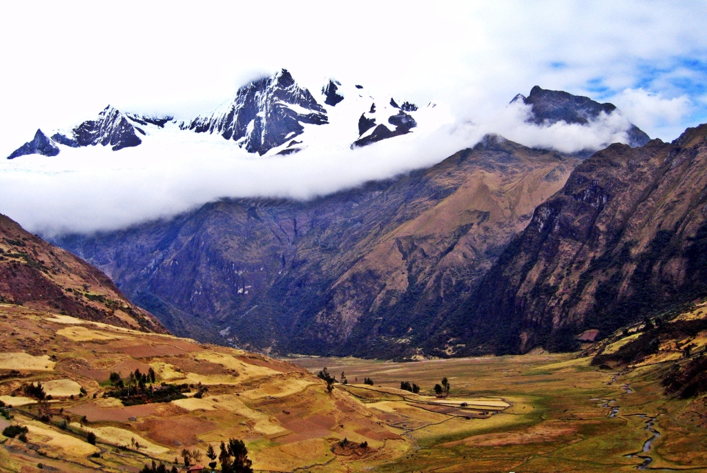
Today felt like a rest day as it was so short compared to the rest of the trek. Since basecamp on the north side of Alpamayo wasn’t good for camping, we decided to stay in the south basecamp (4400 m). On the approach we had glimpses of the majestic Alpamayo ahead. It’s quite a different view on this side than on the north. On the south, the mountain is a broad peak with steep snow runnels covering the south face. This is the side where most of the climbing routes are located. Below Alpamayo is the picturesque Laguna Arhueycocha with icebergs floating in its blue water.


Day 9 – Alpamayo south basecamp to Llamacorral
25 km; Descent 900 m
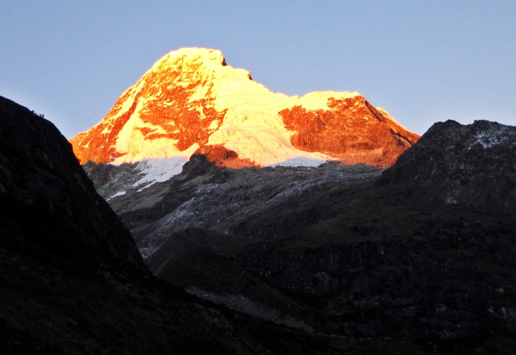
In the morning we had a real treat. The alpenglow on Alpamayo massif was nice, but the view of Nevado Artesonraju across the valley was spectacular. Do you recognize the mountain from the picture below? It’s the mountain used in the Paramount Studios logo. We waited for a movie to begin, but one never did.


We returned to the Santa Cruz trail to continue the trek. Today felt easy as it was mostly downhill. We walked along the valley floor where we passed a few alpine lakes. The Santa Cruz Valley is wide open offering amazing views of the mountains on either side. Our campsite for the night was called Llamacorral (3600 m). Instead of llamas, we saw dozens of donkeys that are used by trekking groups on the Santa Cruz trail. It was a pretty smelly campsite because of these donkeys, but we were too tired to go any further.


Day 10 – Llamacorral to Cashapampa to Huarez
11km; Descent – 700 m
After leaving Llamacorral, the trail slowly descends and we began to see more and more vegetation, until we reached Cashapampa (2900m). After another station-wagon and crowded bus rides we arrived in the town of Huaraz where we treated ourselves to a delicious meal and amber beverages.


Where to stay
The cute town of Huaraz has plenty of backpacker style restaurants, hotels and hostels. There are many mountain activities to do in the Cordillera Blanca and most are based out of Huaraz. Some people use Caraz as a base instead of Huaraz. It’s a smaller town but still has a good selection of budget services and is closer to the start of the trek.
Getting to Huaraz
Buses frequently travel between Lima and Huaraz (8 1/2 hrs). The road climbs from sea level to Huaraz at 3091 m so it may cause problems if you are not acclimatized.
Gettting to Cashapampa
Buses leave a few times a day from Huaraz to Caraz. Collectivos and private cars leave from Caraz’s market for Cashapampa when full. The whole trip will take approximately 3 hours.
When to hike
The best months are the dry months of June, July and August, although the trekking season runs from April to the end of September.
Trekking tips
- Guiding companies in Huaraz provide basic to full services for the trek. It is possible to do this trek on your own without a guide, but you must bring all of the supplies you will need for the entire 10+ days on the trek. If you go on your own, it is important to know that there are no services on this trek. We brought dehydrated meals from Canada, but also purchased bread, rice, nuts and dried fruit in Huaraz. Although you pass villages, they are often just a few farmhouses with no stores or services.
- Water is available on the trail from streams and rivers. You must be prepared to filter or treat it as there are many animals that can contaminate the water upstream.
- The trek is at high altitude with several passes above 4,000 m. Therefore, you must be acclimatized before attempting this trek. You reach very high altitude, 4600 m, on the second night at Laguna Cullicocha campsite. This would be very difficult if not dangerous to do without first spending a few days at high elevation.
- We did the circuit in a clockwise direction beginning and ending in Cashapampa. It can also be done from Hualcayan or Vaqueria, but the latter two add unnecessary kilometers.
Coming Next: Seven Summits – Climbing Danali (Mount McKinley)
For extra pictures from Peru click here. For pictures from other blogs go to Gallery at monkeystale.ca
To read about more of our adventures go to Destinations.
If you like what you read, please comment or share (with credit) using the links below.

Absolutely stunning photos. A great hiking story.
LikeLiked by 1 person
Thank you Roxanne!
LikeLike
Spectacular scenery for sure. Thanks for sharing for for hiking the altitude so we won’t have to. Cheers. Allan
LikeLiked by 1 person
Haha, hiking at altitude is definitely not for everyone. Thanks for reading!
LikeLiked by 1 person
Another fantastic adventure, well told!!! Stunning photos, as ever 🙂
LikeLiked by 1 person
Thanks Colin, we appreciate it!
LikeLiked by 1 person
You are most welcome 🙂
LikeLiked by 1 person
Sounds like it was a very strenuous but beautiful trek!
LikeLiked by 1 person
It was both of those 🙂
LikeLiked by 1 person
What a beautiful trek and what a beautiful post, I could feel the strain, the weight of the bag, the gusts of wind and rain. The photos give the reasons for such an effort, but I guess there must be a great feeling of accomplishment to have seen the place and overcome the difficulties. Thanks for posting such inspiring post.
LikeLiked by 1 person
Thank you, at the time, we were almost too tired to appreciate our accomplishments! But looking back it was a great trek and amazing scenery. Thanks for reading!
LikeLiked by 1 person
Stunning captures, what an amazing adventure! I cannot imagine the adrenaline that must run through you to reach certain points and see these landscapes.
LikeLiked by 1 person
Thank you Donna, it is such a beautiful area. I’m glad that came across in the pictures as much as it did in person.
LikeLiked by 1 person
What an adventure. Good for you folks and congratulations.
LikeLiked by 1 person
Thanks! It was an adventure!!
LikeLike
Just WOW!
LikeLiked by 1 person
Every one of your posts just makes me want to explore South America more and more. The colors and rugged mountains are just unbelievable! Thanks for sharing!
LikeLiked by 1 person
Thanks Diana, you should look into hiking in SA once we’re able to go there again. There are so many incredible spots.
LikeLiked by 1 person
Wow, fantastic photos and I can only imagine what it’s like to pitch your tent in such scenic locations! Your bags look very heavy, how much weight did you end up lunging around on your shoulders? Thanks for sharing and have a good day 😀 Aiva
LikeLiked by 1 person
Thanks Aiva, It’s a gorgeous area to hike and camp. Our packs were around 25 – 30kg at the start. They were so big because in addition to tent, stove, sleeping bags etc we had to carry 10 days of food! Needless to say it was great for weight loss!
LikeLiked by 1 person
I was only vaguely aware of this beautiful area before reading your post. I imagine it and other great treks get eclipsed by the famous Inca Trail. This looks unbelievably gorgeous and difficult. I can see why Alpamayo is considered to be one of the top 3 most beautiful mountains. Your photo at sunrise is stunning. You must have had a moment of major panic when your lighters didn’t work. Thank goodness for the muleteer. Your description/photos of this trek are awesome.
LikeLiked by 1 person
Thanks Caroline, There is so much more to Peru than Machu Picchu. We spent 6 weeks and still couldn’t see everything. This trek is incredibly beautiful and beside it is the Cordillera Huayhuash that is even less known, but supposedly even more beautiful. They are at high altitude though and travel through so many mountain passes, it was exhausting. We thought we were over prepared by bringing 3 lighters, but what luck that they were all empty! We would have had to turn back if it wasn’t for the muleteer as we didn’t see anyone else for days. Lesson learned!
LikeLiked by 1 person
its enough to make me wish i was fit enough to hike like this! The views are just amazing.
LikeLiked by 1 person
Yes, the mountains in Peru are incredible.
LikeLike
This is absolutely stunning. When I was in Peru three years ago, I so wanted to do a lot more hikes (I could only do Salkantay) but unfortunately I was only granted a 20 day Visa. I still feel really bad about missing out on these beautiful treks.
LikeLiked by 1 person
Thank you, Peru has so many beautiful places and many of them are untouched. Hopefully you can return one day. Thanks for reading.
LikeLike
Stunning landscapes!
LikeLiked by 1 person
Yes, the Cordillera Blanca is incredible.
LikeLiked by 1 person
Beautiful pictures! What a hike! I like hiking, but 11 days? Sheesh.
LikeLiked by 1 person
Ya, it was a bit much, especially carrying all of our food, fuel etc. But looking back it was worth it.
LikeLiked by 1 person
More stunning landscapes! Quite the hike!!…and here’s me thinking I’ll do a 4 hour hike near Vancouver…haha
LikeLiked by 1 person
It was the stunning landscapes that kept us going! It was a pretty tough hike, especially carrying all of our gear, but I’d do it again!
LikeLiked by 1 person
What a stupendous walk! Just breathtaking in every sense of the word. Thanks for the inspiration. Mel
LikeLiked by 1 person
Thanks Mel, the scenery in Cordillera Blanca is absolutely incredible. It was a great hike, but you’re right we were often breathless 😉
LikeLiked by 1 person
Most of the landscape looks surreal.. amazingly beautiful is an understatement. I’m a bit jealous you can hike at this altitude (especially with that load), in the good way😍Thank you for taking us in places we’ll never reach, you guys are amazing! Have a nice weekend
LikeLiked by 1 person
Thanks Christie, Cordillera Blanca has incredible views. The trek was difficult, with heavy loads and at the altitude, but we were rewarded almost every day. Thanks for reading!
LikeLiked by 1 person
Wow, what a gobsmacking hike! Very adventurous, but very rewarding. You are brave and adventurous souls.
LikeLiked by 1 person
It was a little tougher than we expected, but the views made it all worth it. Thanks!!
LikeLike
Oh wow, an amazing hike and stunning views!!
LikeLiked by 1 person
Thank you, the scenery in the Cordillera Blanca is amazing. It was a great hike. Thanks for reading!
LikeLike
This reads and looks like a spectacular journey.
LikeLiked by 1 person
Thanks Christoph, it is a great, although tough trek through and incredible mountain range.
LikeLike
Excellent post with great information and of course some really nice photos.
Thanks for sharing
LikeLiked by 1 person
Thank you!
LikeLike