
Hiking around Dolomite Peak in Banff National Park takes you from Mosquito Creek, through Upper Molar Pass, Pipestone Pass and finally over Dolomite Pass. The three-day hike travels through wild mountain country with gorgeous alpine lakes and meadows in front of stunning mountain vistas.
Day 1 – Mosquito Creek to Upper Fish Lakes Via North Molar pass
14.8 km, Elevation Gain – 760 m, Elevation Loss – 365 m
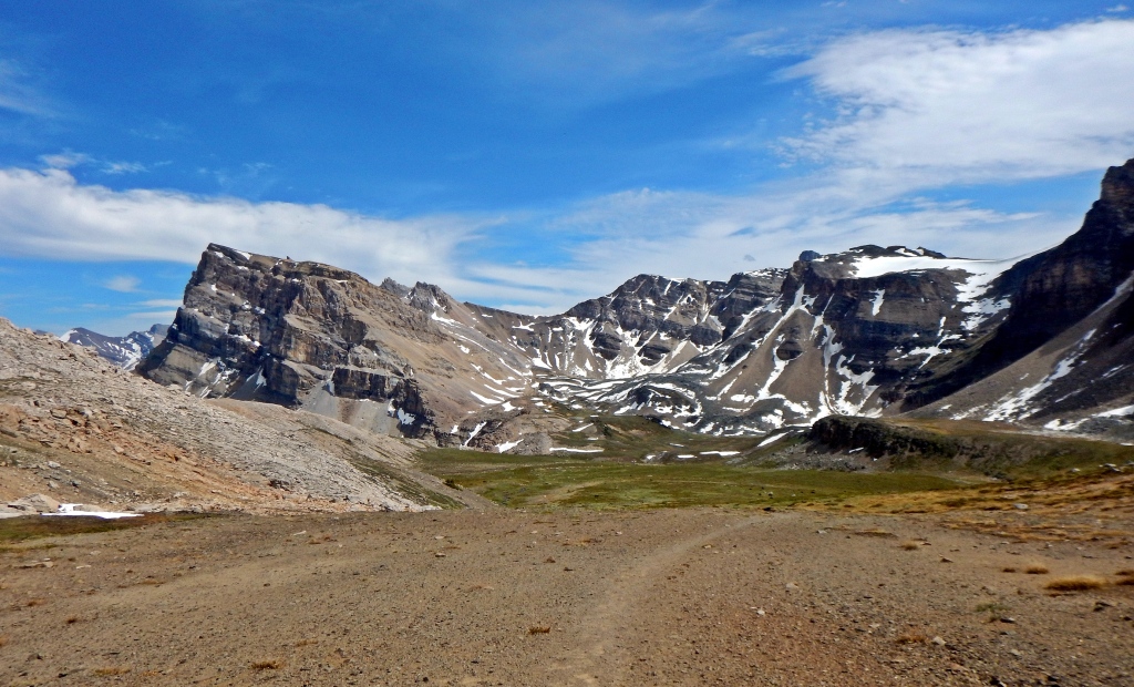
The first seven kilometres follow Mosquito Creek through the trees before emerging onto the gorgeous Molar Meadows. This vast area is backdropped by the impressive Dolomite Peak. The beauty of this meadow is overwhelming. Rolling hills slowly lead up to North Molar Pass (2590 m) with spectacular views of the meadow behind you as you climb. The final push up to the pass is steeper and depending on the year, is often snow covered and can be impassable so check the route conditions before heading out.


From the pass enjoy the view of Molar Mountain’s peak in the distance. At its base is Upper Fish Lake and the first campsite (2225 m) of the trip. This lovely alpine lake is protected on one side by barren rocky mountains but has green grass on the other making a lovely campground. This is a popular campground so may need to book ahead.


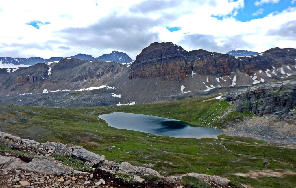
Day 2 – Upper Fish Lakes to Isabella Lake Via Pipestone Pass
25 km, Elevation Gain – 245 m, Elevation Loss – 640 m
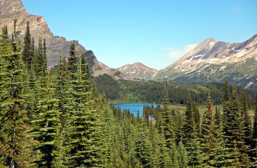
From the campground we followed a faint detour trail that passed Moose Lake and other small alpine tarns on its way to Pipestone Pass (2470 m). The formal trail would have meant a lot of elevation loss and regain. By taking this detour we stayed high, and out of the trees so we could enjoy the incredible scenery. From the open pass you can see far down the gorgeous Siffleur Valley. Just beyond the pass is a trail leading to Clearwater Pass and Devon Lakes which could be used as an intermittent campground.
After dropping down into the Siffleur Valley we are back in the forest and on much more boggy land. There are a few river fordings in this part of the trail. When we were there the Siffleur River wasn’t too high so we could rock hop some sections, but had to take our boots off for others. Crossing Dolomite Creek was the toughest ford as the fast moving water was mid-thigh deep, and freezing cold. It was a tough day carrying full packs, but finally, we made it to the mosquito ridden Isabella Lake (1830 m).


Day 3 – Isabella Lake to Helen Lake trailhead Via Dolomite Pass
22.3 km, Elevation Gain – 575 m, Elevation Loss – 455 m
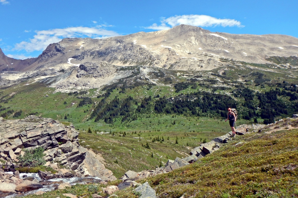
The day began following Dolomite Creek. The trail skirts rocky cliffs with a few small waterfalls before coming to a large open meadow. In the distance we spotted a huge grizzly ambling along on the creek. We made a lot of noise to alert him that we were near. He watched us for a while, and then decided we weren’t of interest and went on his way. It’s always unnerving seeing a grizzly in the mountains. It’s important to make noise as you walk in bear country so the bear knows where you are without being startled. Bears usually respond as they should and go in the other direction.


From the bottom of Dolomite Pass we began a slow ascent up the steep, rocky trail. At the top of the pass we saw two marmots eating a Parks Canada sign! This area is known for having a lot of these cute fuzzy animals. They were so busy with their eating that they barely paid us any attention.


From Dolomite Pass (2395 m) we had an incredible view of Katherine Lake and across to Dolomite and Cirque Peaks. An easy walk in this open area takes you to Helen Lake which is a popular day hike destination.


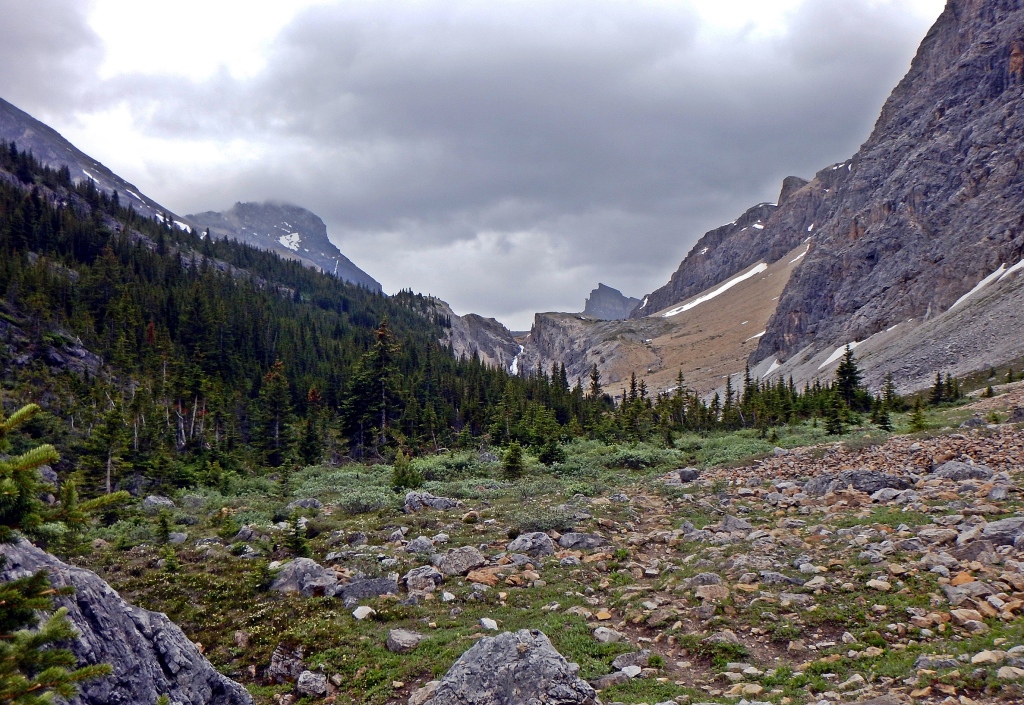
Leaving Helen Lake the trail circles around Dolomite Peak. Its ragged peaks on this side of the mountain are what reminded early mountaineers of the Dolomites in Italy. From there the hike goes back into the trees but opens for a nice lookout to Crowfoot Glacier and Bow Lake below. The trail ends after a final descent to the Helen Creek trailhead on the Icefields Parkway.


Trip Details
This loop takes you through a wild part of Banff with little trail maintenance and involves a few river fords, but the landscape is incredible. There is another campsite just off the trail at Devon Lakes to make this a 4 day hike and break up the long day from Fish to Isabella Lakes.
Distance – 62 km
Elevation Gain – 1580 m
Days – 3 – 4 days
Access – We did this hike in a counter-clockwise direction which is the most common direction however, it’s not a complete circuit. The trail ends at Helen Creek trailhead which is about 5 km north of the Mosquito Creek parking lot. Leave your car at one end and either walk or try to catch a ride to the other. Both are located on the Icefields Parkway (Hwy 93). Mosquito Creek is 24 km north of Lake Louise.
Campgrounds – There are a few backcountry campsites with tent sites, outhouses, wires for hanging food and picnic tables. They are situated near running water, but this water must be filtered or treated. Most don’t allow open fires so you need to bring a camping stove. There will be no cell reception at any of the backcountry campgrounds in Banff. There are camping fees for these sites. Depending on the time of year you may need to book your campsite in advance. You can book at the park office in Banff or on-line here.
Fees – You do require a park pass if you plan on stopping at all inside of Banff or Jasper National Parks. Passes can be purchased from the park offices in Banff and Jasper and at all park gates in the summer. In winter some ticket booths are closed, but you still require a pass if you intend to stop. Park staff frequently check parked vehicles in town and at trailheads.
When to hike – Mid July to mid September should have the best conditions. Depending on the year there is likely to be too much snow even on the first of July and it may begin snowing again in September. We attempted this hike on the Canada Day long weekend (July 1st) one year and had to turn back because there was still too much snow. Eventually we did the entire route in mid August.

TIPS FOR HIKING IN THE CANADIAN ROCKIES
- Expect sudden changes in weather. Bring a rain jacket, an extra sweater, gloves and a toque for one-day or multi-day hikes.
- Hiking poles are useful in many areas and can help save your knees when going down steep descents.
- Water taken from streams will need to be treated, filtered or boiled.
- Bring bear spray and/or bear bangers and educate yourself on wildlife safety.
Here’s a short video from many of our hikes and climbs in the Canadian Rockies.
Read about hiking Tonquin Valley, Wapta Icefields in Summer, Brazeau Lake-Jonas Pass.
Coming Next: Top 10 Day Hikes from Calgary – Banff Edition
For extra pictures from Canada click here. For pictures from other blogs go to Gallery at monkeystale.ca
To read about more of our adventures go to Destinations.
If you like what you read, please comment or share (with credit) using the links below.

Perfect place to hike…love Banff.
LikeLiked by 1 person
Yes Banff is such a beautiful park!
LikeLike
Looks stunningly beautiful.
LikeLiked by 1 person
Thanks Ken, it’s an incredible area.
LikeLike
You just can not beat the beauty of the Rocky Mountain meadows. Looks like a great hike, well worth the effort. Thanks for sharing. Allan
LikeLiked by 1 person
Thanks Allan, we agree. We travel around the world but the views at home are pretty incredible. Thanks for reading! Maggie
LikeLiked by 1 person
Thank you for your post showing stunning scenery again. The Rocky Mountains in Canada are incredibly beautiful !
LikeLiked by 1 person
The Rockies have so many incredible views and awesome hikes. Thanks for reading!
LikeLiked by 1 person
Almost like being there.
LikeLiked by 1 person
Thanks Michael.
LikeLike
Another wonderful post!! As always, accompanied by some gorgeous panoramas! Oh and I love the “no cell reception” line haha. I’d imagine not can you even pick-up FM radio up there? 😉
LikeLiked by 1 person
But you’d be surprised how many people expect to use their phones! You can’t even get reception on parts of the mountain highways. 😊
LikeLiked by 1 person
It’s amazing how quickly some folk have become reliant on them. I grew up in a rural area where we barely got a decent TV signal and no AM radio at all, so, I still have a vestige of “no signal” mentality left in me haha
LikeLiked by 1 person
I know it’s ridiculous! It would never occur to me that I should or want to be always connected. It’s so nice to ‘unplug’
LikeLiked by 1 person
Beautiful landscapes. Looks like a great hike
LikeLiked by 1 person
Thanks Arv, Banff is a great place to hike in the mountains.
LikeLiked by 1 person
Oh my goodness the marmots, haha. I love all of your adventure posts!
LikeLiked by 1 person
Thanks Tia!! Those marmots were hilarious. I have tno idea what the sign said!
LikeLike
It’s very refreshing to read the post, even if there is a lot of effort behind it. The landscapes are breathtaking and the marmots are so unexpected in this rascal role. Great thanks.
LikeLiked by 1 person
Thank you! It was a lot of effort, but the kind we enjoy! The marmots were really a funny surprise. Thanks for reading! Maggie
LikeLiked by 1 person
You two must have won the lottery to be able to go on so many great trips! Beautiful photos as always
LikeLiked by 1 person
Well this one is a weekend getaway from home, still hoping for that lottery!
LikeLiked by 1 person
Such breathtaking scenery!! We loved Banff when we visited four years ago, though we have not seen marmots. I didn’t know they are in the mountains.
Enjoy the rest of the summer!
Christie
LikeLiked by 1 person
Thanks Christie, there are quite a few places in the Canadian Rockies where marmots thrive. Thanks for reading! Maggie
LikeLiked by 1 person
Gorgeous scenery once again! you must have a tough time deciding what to hang on your walls 🙂 Ahhhhh a grizzly! Now that would be unnerving! I’ve seen one in Waterton from a distance and they are huge. Love the marmots…I bet they used that sign to line their nest….crafty creatures.
LikeLiked by 1 person
Haha, yes there are so many scenic spots around here, it is a tough choice. I didn’t think of it, but you’re probably right it was for their nest! It was a hilarious site!
LikeLiked by 1 person
I hope to see a Marmot before we leave British Columbia to make our way to Nova Scotia! Exciting about the grizzly!
LikeLiked by 1 person
Exciting like you seeing a whale on a kayak! Come to Alberta, there are so many marmots in the mountains here!!
LikeLiked by 1 person
What an epic hike! Breathtaking scenery. I know what you mean about those grizzlies. I was hoping to see one (from a safe distance) in the Chilcotins but all we saw was plenty of poop and tracks. Those marmots are hysterical. We’re so lucky to be able to visit these spectacular places without leaving the country.
LikeLiked by 1 person
Thanks Caroline, I know I shouldn’t complain about staycations, we do have it pretty good. We are looking to book another multi-day hike but with all of the new policies backcountry campgrounds iare full! Only 1 or 2 tents per site I guess.
LikeLike
I virtually travelled with you. Wonderful photographs! Thank you for sharing! ❤
LikeLiked by 1 person
Thanks for coming along, glad you enjoyed the views!😊
LikeLike
Once again, what a lovely post!
I really enjoy following your blog because you have really good descriptions and stunning photos!
The Waterfall on the way to Dolomite Pass and the Upper Fish Lake look really nice.
Thanks for sharing and I already look forward to your new posts.
LikeLiked by 1 person
Thank you so much! You’ll have to come to the Canadian Rockies for some hiking and we’ll go to Greece!
LikeLike
That’s indeed correct! Though, with all the mountains I would like to visit in Canada, I should stay there for at least 4-6 months!
Canada has amazing nature with beautiful landscapes and plenty to offer for mountaineers like me!
LikeLiked by 1 person
😊😊
LikeLike
Looks like a lovely multi-day hike. And how exciting that you saw a grizzly bear (safely at a distance). Were the mosquitoes bad at Mosquito Creek?
LikeLiked by 1 person
Haha no surprisingly the mosquitos were fine at their creek but so bad at Isabella Lake that we didn’t even take a photo of the lake, we hid in the tent!
LikeLiked by 1 person
Wow! I can imagine how nice it’ll be to take in the views. They’re the best! You’re bold oo, I don’t think I can stand making noise in front of a bear and this trail is not for me. I can’t stand wildlife in the open.
LikeLiked by 1 person
Haha, it is scary, but in the backcountry the bears are usually more afraid of us. It’s closer to towns where they get used to human food that they become a problem.
LikeLike
Hmm. That’s great to know. But I’m scared of getting close to one nonetheless.
LikeLiked by 1 person
Fabulous photos, winch big country. You do some incredible long y make ours look like strolls in the Park 😁
LikeLike
While living in Italy I never made it here, which slays me after seeing your post. Thank you for sharing the hike photos.
LikeLike
nothing like hiking just below the snowline!
LikeLike
Your pictures are so calming and gorgeous. Those peaks are stellar!
LikeLiked by 1 person
Thank you! Banff is a beautiful park with so many amazing mountain views. Thanks for reading!
LikeLiked by 1 person
What a fantastic place to hike. We would absolutely love to explore Banff at some point – it looks spectacular. Brilliant photos and especially loved those cheeky marmots eating the sign! Thanks for sharing
LikeLiked by 1 person
Banff is beautiful with so many hikes, and much quieter than other hiking destinations. Keep it on your list! Thanks for reading😊
LikeLike
Beautiful place. I’ve always wanted a holiday in Banff, and the prospect of a throwback to the 90s (no cell phone) would be the icing on the cake.
LikeLiked by 1 person
Banff has so many beautiful spots, I hope you get to come some day. It is really nice to be completely unplugged for a few days.
LikeLiked by 1 person
amazing work
LikeLiked by 1 person
Thank you!
LikeLike
Well explained! Pictured are beautiful!
LikeLiked by 1 person
Thank you so much and thanks for reading!
LikeLike
Ohh, looks like a perfect place for hiking! Thanks for sharing, I felt like I was there too!
LikeLiked by 1 person
Thanks for coming along on the hike😊. Banff is a great place for hiking.
LikeLike
Wow
LikeLiked by 1 person
Great pictures! Banff is a great place for hiking – and photography!
LikeLiked by 1 person
Thank you, we love Banff, it’s so photogenic!
LikeLiked by 1 person
Wow. Really beautiful there.
LikeLiked by 1 person
Yes, Banff National Park has incredible scenery. Thanks for reading! Maggie
LikeLiked by 1 person