
Sometimes Mother Nature gets it right. One of the most majestic mountains in Canada is perfectly situated above 3 gorgeous blue lakes set in a dense evergreen forest. Mount Assiniboine has been touted as the ‘Matterhorn of the Rockies’ for its tall, pyramidal shape and dominating presence. It is a favourite destination for many mountain lovers and should be on your must-see list.
Mount Assiniboine lies near the border between British Colombia and Alberta. There’s no short way to hike in or out of Assiniboine Provincial Park. We did a two-day hike that took us from Sunshine Village Ski Resort in Banff National Park to Lakes Og and Magog in Mount Assiniboine Provincial Park. We prefer this approach because it provides very scenic views passing through the open Sunshine Meadows and Valley of Rocks with glimpses of Assiniboine throughout the trip. For other access options click here.
The hike in
Sunshine Village Ski Resort to Og Lake
Distance – 29.3 km; Elevation Gain – 950 m
In the strange summer of 2020 Sunshine Village is closed and therefore so is their gondola. Usually you could take the gondola from the parking lot to the Village and begin the trek from there. Instead we had to add an hour and a half trudge up the gravel access road to reach Sunshine Village.

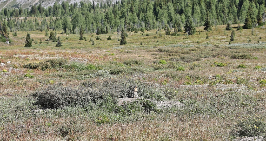
From there however, the hike is amazing. Sunshine Meadows is a large, open area with expansive views. The hike crosses the large meadow allowing us to admire the vista for a while. If we had more time we would have stopped at the pretty Rock Isle Lake, but it was a little too far off our route. The meadows are inhabited by hundreds of Colombia ground squirrels who screeched at us as we passed. Although we didn’t see any bears, there were plenty of recent digs. Grizzzlies dig deep in the ground searching for the screeching rodents.
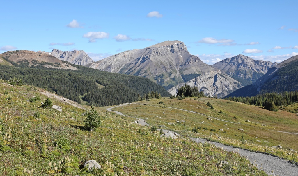


The rolling hills of the meadows lead up to a lookout above Howard Douglas Lake. It’s a small, but very pretty blue lake surrounded by fir and larch trees. From the lookout the tip of Mount Assiniboine can be seen rising above the other mountain tops.


After passing the lake, the meadows continue and slowly lead up to Citadel Pass (2360 m). With the rugged looking Citadel Mountain beside us and a better view of Mount Assiniboine in the distance, it’s a nice spot for a rest.
After the pass, there is a steep descent as the trail heads far down the tight valley to Porcupine Campground. The campground is in the trees under the ridge of craggy topped mountains so there isn’t much of a view, but it’s a good place to stop for the night. If you’re not stopping, you can by-pass the campground and avoid the final 100 m descent.
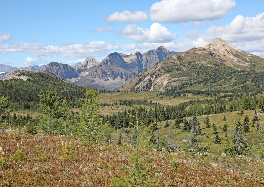


From Porcupine Campground, the trail wanders through the trees to the small but pretty rocky Golden Valley. Then it climbs up and down a few ridges before reaching the interesting Valley of the Rocks. It was formed by an ancient rockslide that left its remains scattered around this large valley. The trail meanders between and around boulders of all sizes and shapes.


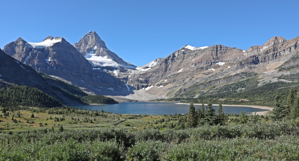
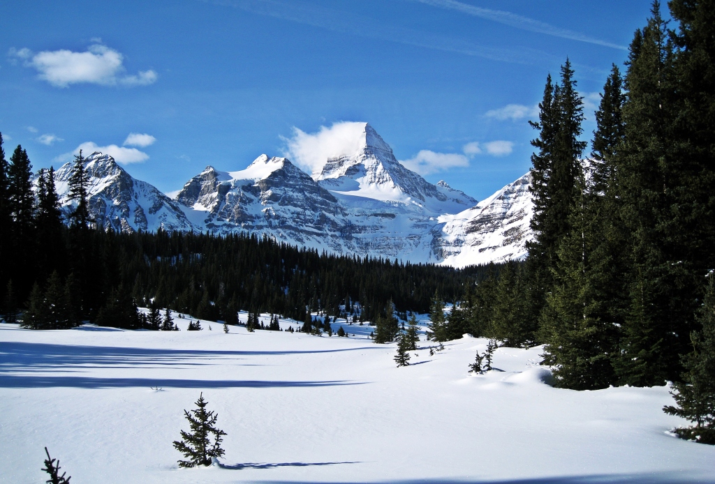
After the Valley of the Rocks the trail climbs to a lookout above Og Lake. What a spectacular view of the lake with Mount Assiniboine in the distance! We ski toured this same route in winter. Below is the winter view from close to the same spot.


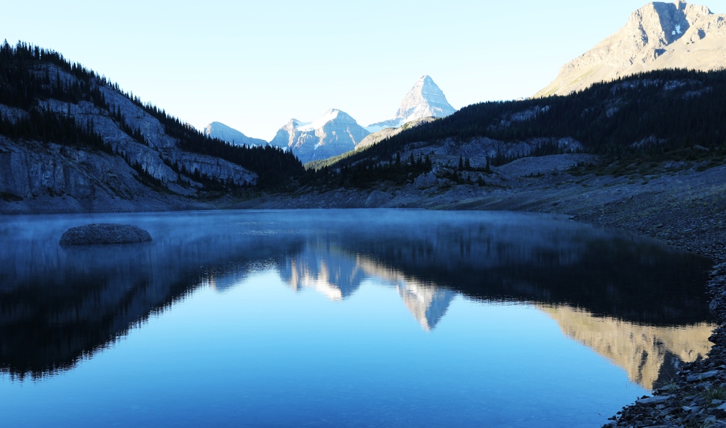
Og Lake seems to be hiding behind a rocky outcrop below Windy Ridge, but when we get close we see it’s not enclosed. At its far end, the outcrop opens up for a fantastic view of Assiniboine. When the water is calm there is a perfect reflection on the lake. In the evenings we saw amazing alpenglow sunsets on the mountain which reflected on the still lake.

What to do in Assiniboine Provincial Park
After hiking 30 km to get to this spot, it would be a shame to turn around the next day and head out. Instead, plan to spend a couple of nights exploring this incredible area.
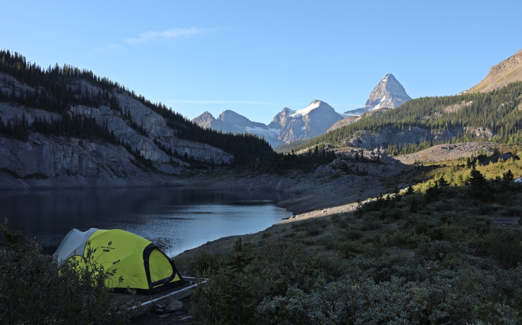
Enjoy the scenery at Lake Magog
This pretty lake sits at the base of the mighty Assiniboine and has the classic view of the massif. It’s the main area that people come to see. You can walk along the lake and find a quiet spot to sit and enjoy the view from its edge. There is a campground, a lodge and backcountry huts around the lake, but it never feels busy. The second picture below is from 2008, roughly the same time of year. You can see the difference in snow in the two years.

Hike to Nublet or Nub Peak
Distance – 4 km one way; Elevation Gain – 600 m
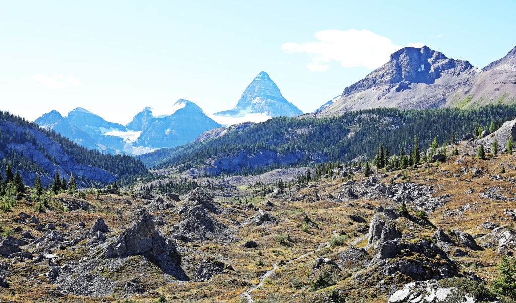
It seems as if Nub Peak was purposefully placed where it is to give you the most amazing views of Mount Assiniboine. The hike is accessed from Magog Meadows and begins as a gentle climb through a tight forest of fir until it becomes more sparse with larch trees. At the first ridge (sometimes called Niblet) is a lookout with nice views of Cerulean Lake, Mount Assiniboine and Lake Magog.

The trail leaves the lookout and follows a steep open, rocky trail up to the next viewpoint, offering better and better views as you climb. From the Nublet plateau you’ll find one of the most amazing views in Canada. Mount Assiniboine has a commanding presence towering over the three blue lakes; Magog, Sunburst and Cerulean. The scene is so perfect that you can’t take your eyes off it. Another 2 hour scramble will take you to the top of Nub Peak but we think the best views are from Nublet.


Hike to Og Pass and Windy Ridge
Og Pass is right above Og Lake, but its access is closer to Magog Lake. It’s an easy hike up a small hill for another view of Assiniboine towering above (distance – 6 km; elevation gain – 300 m approx.). The actual pass is down in the wide valley that used to be a horse route from Banff to Assiniboine. For better views you can continue following the trail to the top of Windy Ridge (2635 m).


Hike to Wonder Pass
Distance – 3.5 km; Elevation gain – 205m
If you’re not hiking in or out via Wonder Pass, you can still visit it in a nice easy day hike. From Lake Magog follow the trail through the open meadow reaching the small, peaceful Gog Lake. From there the trail climbs up through a sparse forest passing a lovely waterfall. The pass is a large open area with a few larch trees and looks out to Marvel Peak and Mount Gloria. It would be lovely in the fall when the larch needles have changed to a golden colour.


Visit Og Lake
If you’re staying at Lake Magog, the 6 km hike to Og Lake is a worthwhile objective. Set in a rocky valley, Og Lake offers one of the best views of Assiniboine. It’s often overlooked because Lake Magog has the classic view, but this pretty lake shouldn’t be missed. The hike between the two travels through Og Meadows which is covered in low brush that provide a nice green colour to the landscape. We’ve also done this route in the winter on skis. The final picture is a wintery scene from Og Meadows for comparison.


Visit Lakes Sunburst, Cerulean and Elizabeth
We didn’t go visit these lakes, but from Magog meadows there are three relatively easy hikes to that take you to these pretty lakes. These hikes are well marked on sign posts.
Access
There are a few ways to get to Mount Assiniboine Provincial Park. None of them involve a car.
Helicopter – Those with little time or interest in hiking can take a helicopter in and out from either Canmore or Mount Shark.
Hiking – There are also a few different options for arriving on foot. You can hike in and out from Mount Shark using two different routes, or hike Sunshine to Mount Shark (or reverse) and take the shuttle to return to your car. For shuttle times and costs click here.
- From the Mt. Shark Nordic ski trails parking lot in Kananaskis, two trails take you to Lake Magog. They both leave Mount Shark on the trail to Bryant Creek where the trail splits. Both can be done in one long day, or stay at one of the campgrounds near Bryant Creek. Many people will hike in one trail and out the other.
a. Assiniboine Pass – One trail leaves Bryant Creek via Asssiniboine Pass. It’s a flat but less scenic option. Distance: 27.5 km Elevation gain: 460 m

b. Wonder Pass – A second trail goes via Wonder Pass. It is by far prettier but has a bit more elevation gain. The trail travels above the 5 km long Marvel Lake. Distance – 26 km; Elevation gain – 580 m


Marvel Lake pictures courtesy Eliza.
2. Sunshine – The hike from Sunshine Village Ski Resort, through Citadel Pass and then to Assiniboine is the most scenic option. Distance – 23 km and roughly 450 m elevation gain (In summer 2020 Sunshine Village gondola is closed so it adds 6.5 km and a gain of 525 m to the trip.)
3. Finally a trail goes through Allenby Pass and then Og Pass. It is a longer hike with fewer camping options as well as being a horse route. It is the least favoured option by hikers.
Where to stay
Assiniboine Lodge
This gorgeous private lodge offers lovely accommodation on the shores of Lake Magog. In the summer of 2020 however, the lodge is closed.

Naiset Huts
More rustic than the lodge, these huts have dormitory sleeping, a cooking room, outhouses and food storage. You need to bring your own food.


The lodge and huts can be booked on-line here
Campgrounds
There are 2 main campgrounds near Mount Assiniboine, Lake Magog and Og Lake. They both offer pluses and minuses. Lake Magog is situated right below Assiniboine and has amazing views, but is larger and busier. Og Lake is 6 km away so you have to hike to access most trails. Its quieter and has different, but also spectacular views of the mountain.
The campgrounds have a cooking area with grey water dump, lockers and or poles for food storage. Water is available but must be filtered or treated. Og Lake had one of the cleanest outhouses we’ve seen and a large supply of toilet paper! Campgrounds can be booked on-line here . During the peak summer season, you must have a pre-booked campsite as there are no walk-in sites available.
Bryant Creek Area Campgrounds – If you’re hiking from Mount Shark you can break up the long day by staying at BR9, BR13, BR14 or the Bryant Creek Shelter (Book these campgrounds here)
Porcupine Campground – On the hike in we stayed one night at Porcupine Campground. There are no fees and no reservation is necessary, but it is a first-come first-served site. There is a cooking area, food storage lockers, tent pads and an outhouse. Water is available from the stream and must be filtered or treated.
Tips for a great stay in Mount Assiniboine
• Bring warm cloths as it can get very cold. This year we went on the last week in August and overnight temperatures were 4° C. On our hike out, the last 45 minutes we were in a hail storm.
• On day hikes expect sudden changes in weather. Bring a rain jacket/gortex, an extra sweater, gloves and a toque in a small backpack.
• Bring bear spray and/or bear bangers and keep watch for all wildlife. Educate yourself on safety in the backcountry.
To ead our other hikes from around the world go to Treks.
Coming Next: The Classic Wapta Traverse in the Summer
For extra pictures from Canada click here. For pictures from other blogs go to Gallery at monkeystale.ca
To read about more of our adventures go to Destinations.
If you like what you read, please comment or share (with credit) using the links below.

I love your blog. Pictures are beautiful and you have enough information provided for others to follow your footsteps and often with options.
LikeLiked by 3 people
Thank you! We hope someone can use our information on a trip of their own some day. Thanks for reading! Maggie
LikeLike
Glad I did the best part of this hike last year. It was the experience of my lifetime and the views were well worth the effort to took to get there at the age of 66. While we were tempted to hike to Assiniboine Lodge for Happy Hour, the joy of surviving a thunder hail storm at Og Lake became our choice. Who needs a beer anyway when you are high on the mountain scenery. Thanks for sharing. Allan
LikeLiked by 2 people
You certainly did hike the best route. It’s so much more scenic than the views from the Kananaskis side. A beer at the lodge would have been pretty nice though, we didn’t have to get the choice to have one or not since they’re closed. We did bring wine though so that was nice in front of the alpenglow. Maggie
LikeLiked by 1 person
This looks amazing…(Suzanne)
LikeLiked by 2 people
Thank you Suzanne, it’s actually nice to re-explore parts of Canada. There are some incredible landscapes aren’t there. Maggie
LikeLike
Seems like you do not need to do any international traveling: enough great spots near you in Canada!
LikeLiked by 2 people
I know, we tend to forget how great we have it I our own backyard don’t we.
LikeLiked by 1 person
Yes, for years I mostly traveled in Asia, Africa and Latin America, but now I am discovering many great places in Europe.
LikeLiked by 1 person
Another great post and what fantastic scenery. I’d seen some shots of Mt Assiniboine before but yours put it into perspective and expand the vista. Really stunning. Thanks for sharing this!
LikeLiked by 2 people
Thank Colin, we were again stunned at how amazing the scenery is. Even seeing it again, it’s still shockingly beautiful!
LikeLiked by 1 person
Yes, it’s the scale that captivates me. I always have to view your posts on the PC to better appreciate them!! 🙂
LikeLiked by 1 person
This looks like yet another spectacular hike! Can you imagine staying in that little secluded cabin with such stunning mountain views? I certainly can. Thanks for sharing, Canadian Rockies are what dreams are made of, can’t wait to see them again one day. Aiva 😊
LikeLiked by 2 people
I’d love to stay in that cabin, unfortunately we’re always in a tent😊 Time to splurge I think. Maggie
LikeLike
I really like the Alpenglow photo.
LikeLiked by 2 people
Thank you, we’re glad we had perfect conditions for that view.
LikeLiked by 1 person
Yay! more from the Canadian Rockies…I too love that Alpenglow photo…although all of the reflections are spectacular! Looking forward to hiking in Yoho blog 🙂
LikeLiked by 2 people
We were so lucky with that alpenglow!! Stay tuned, looks like we’ll keep hiking and then skiing here for the rest of the year!
LikeLiked by 1 person
Super awesome hike. I have never heard of this mountain. It does look like a pristine place
LikeLiked by 2 people
Thanks Arv! Most mountains in Canada are only famous in Canada I think. We’re not good at boasting😊 This one has a particularly amazing setting. We’re shocked seeing it even for the 4th or 5th time!
LikeLiked by 1 person
Possibly. That’s true. It sure has an amazing setting. 🙂
LikeLike
Fascinating! Photos are just stunning. Living vicariously through your adventurous.
LikeLiked by 2 people
Thanks Leighton! You have enough adventures if your own I think!
LikeLiked by 1 person
The resemblance with Matterhorn/Cervino from the Swiss side is uncanny! I also found it a bit like Monviso. Beautiful!
LikeLiked by 2 people
It’s unbelievable how much it resembles the Swiss Matterhorn isn’t it? The difference is the amount of people who climb it. Not many here as it is a technical climb and this year the climber’s hut is closed. Monviso is similar but it’s also the surrounding lakes that makes Assinivoine special -at least here anyway.
LikeLiked by 1 person
It does indeed look like the Matterhorn! 😁 Amazing post! And your photos are breathtaking…. I realize how much beauty exists in my home country which I may never get to see. Thank you for sharing
LikeLiked by 2 people
Thanks! I didn’t realize you were from Canada, I thought US for some reason. There are so many beautiful places to see here, but I’m loving your hiking trips in Europe too.
LikeLike
Lotta hiking! Looks magnificent. The only hike I’ll be doing today is to the park for some Indian summer that’s hitting x
LikeLiked by 2 people
magnificent as always!
LikeLiked by 1 person
So majestic!
LikeLiked by 2 people
Yes it commands your attention. Thanks for reading! Maggie
LikeLiked by 1 person
This one is on my list too. My sister raves about the scenic beauty. Your photos are stunning and it’s interesting to see the summer/winter contrast (both are gorgeous). Do the campsite reservations get booked up quickly?
LikeLiked by 2 people
It’s worth it and it’s not a difficult hike to get there. The two trails from the Kananaskis side are quite boring though. In a usual year the campsites are full on long weekends but week days and most other weekends you can get a spot. This year though it was booked for the entire summer within a couple of hour of Parks Canada opening thier on-line booking! We were lucky to get 2 nights when people cancelled. If you do go plan to spend 2 or 3 nights there because there are a lot of hikes in the area. How’s the smoke in Vancouver? It’s awful here. We can barely see across the street never mind across the valley!
LikeLiked by 1 person
Thanks Maggie. Same thing happened here this summer with campsite bookings. I guess it’s not a surprise. Sorry to hear that your smoke is terrible too. It’s so bad here that I don’t even want to go outside. Between that and the news I just got that the Squamish Sea to Sky Gondola cable was cut again, it’s a pretty bleak day.
LikeLiked by 1 person
I hadn’t heard so we just read the articles about the gondola. That’s awful! What’s wrong with people! We’re not even going outside to the grocery store, the smoke is so bad here.
LikeLike
Those morning reflections on Og lake are BEAUTIFUL photos! Thank you for sharing.
LikeLiked by 2 people
Thank you Brandy. We were pleasantly surprised by this view!
LikeLiked by 1 person
Absolutely stunning photo’s again, love them
LikeLiked by 2 people
Thank you! It’s a gorgeous park.
LikeLike
Okay, WOW! Your photos are unreal, especially the reflection shots! Plus that view from the Nublet must be one of the best in Canada, if not the world!? I’m not sure that this is one I’ll ever get around to doing so it’s great to have a virtual tour of it.
LikeLiked by 1 person
Thank you! Yes the view from Nublet is breathtaking, even on the 2nd or 3rd time. There may be a better view but I can’t think of one..Thanks for reading! Maggie
LikeLiked by 1 person
Stunning views! and great blog post!
LikeLiked by 1 person
Thank you very much, this is one of the most beautiful places in Canada.
LikeLike
This looks so beautiful and is definitely on the bucket list. thanks for sharing and look forward to following your adventures 🙂
LikeLiked by 1 person
Thank you, you should definitely include the Canadian Rockies on your list!
LikeLike