
Crossing a deeply crevassed glacier is not a trip for the faint of heart, but it can give you amazing views and a great sense of adventure. Wapta Traverse is a classic winter ski traverse in the Canadian Rockies, but as we found, it is also an amazing place in the summer.
One year when massive forest fires in British Columbia and Alberta caused most hiking areas to be closed, we decided to hike in the one area that was open. The 2020 wild fires that are currently ravaging throughout the western US have filled our skies with smoke and reminded us of this earlier trip.
The Wapta Traverse crosses a large, crevassed icefield in a wild part of the Canadian Rockies between Banff and Yoho National Parks. We had done this traverse a few times in the winter, but this was our first time in the summer.
Bow Lake to Balfour Hut
Distance – 15 km; Elevation gain – 970 m; Elevation loss – 430 m
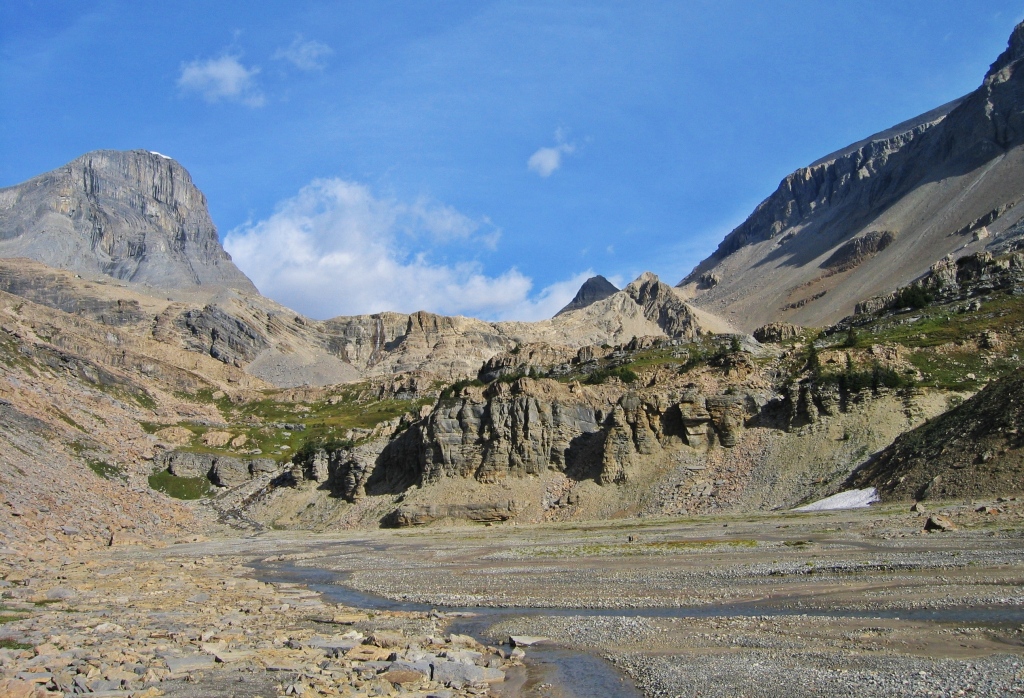
The hike begins at the picturesque Bow Lake on the Icefields Parkway. We’re often in this area in the winter, but seeing the landscape in the summer is like being there for the first time. From the lake you can see Bow Glacier and St. Nicholas Peak high above. In a few hours we’d be crossing under that distinctive peak.

With our heavy packs loaded with supplies for the three day crossing we set off on the trail. The hike goes around the Bow Lake following the trail to Bow Hut. After the lake we arrived at a narrow, rocky canyon guarded by steep cliffs. The winter route goes through the tight canyon, but the summer trail climbs above it on a large moraine. Above the canyon are great views of the hanging Bow Glacier ahead.


Above Bow Hut the trail crosses a moraine to reach the glacier’s edge. We are aware of the big commitment we are undertaking as we gear up with crampons, harnesses and ice axes and take our first step on the ice.
Bow Glacier is very convoluted with deep crevasses in an intricate design. Finding the best route takes patience, experience and persistence. We made our way back and forth, weaving between the fissures. Our route looked like a Family Circle comic of the kids taking a circuitous route around the neighbourhood. Eventually we crossed the icefield beneath St. Nicholas and through the Olive-St. Nicholas Col to get to Vulture Glacier. The skies had an eerie smoky haze from the forest fires surrounding us as we walked across the large white glacier.


We worked our way down Vulture Glacier beside the rugged Mount Olive. After a few hours we can finally see our first objective, Balfour Hut, in the distance. The hut is set on a rock band in a glacial valley surrounded by Wapta’s peaks. That night we had a spectacular red, smokey sunset. The picture of the hut below is from a winter trip.


Balfour Hut to Scott Duncan Hut
Distance – 10 km; Elevation Gain 520 m; Elevation Loss 320 m
Between Balfour and Scott Duncan Huts, the route is more complicated as the glacier is even more convoluted. There is also a risk of ice fall where it crosses under Mount Balfour on the way to Balfour Pass. We leave early in the morning to make it safely through the worst area.


Above Balfour Pass, the huge Waputik Glacier lies in front of us with sweeping views of far away peaks. Another day of tricky glacier navigation leads us to the small Scott Duncan Hut perched on the moraine below Mount Daly. As the fires continued in the valleys we had another amazing sunset from the glacier.


Scott Duncan Hut to Great Divide Lodge
Distance -12 km; Elevation Loss -1060m
Our last day involved crossing to the end of Waputik Glacier. In winter the route goes through the pass between Mount Niles and Mount Daly, but in the summer it goes down the steep moraine beside Niles Creek. After a lot of walking on wobbly boulders and loose scree, we can see Sherbrooke Lake far below.
Sherbrooke Lake is a pretty, turquoise lake and is a popular day hike as its close to the highway. We were thankful to end our trip with an easy walk from the lake, through the woods to reach our car.


Trail information
The Wapta Traverse takes you from Bow Lake on the Icefields Parkway in Banff National Park to the the Great Divide Lodge on the #1 Highway in Yoho National Park. This glacier traverse should only be attempted by those with experience or with a certified guide. Having said that it is an incredible traverse with amazing views.
On paper it’s only 37 km, but navigating around crevasses on the large Wapta Icefield, the actual amount of walking is much more. Total elevation gain is 1490 m and total elevation loss is 1810m.
Where to stay
We stayed in Balfour and Scott Duncan Huts which are operated by the Alpine Club of Canada. There are three other huts in this area; Bow, Peyto and Louise & Richard Guy. The huts require advance booking, and in busy winter months may be completely full. In the summer however, they are rarely used. The huts have sleeping mats in a dormitory style room, kitchens with pots and pans, dishes, and outhouses. You need to bring your own food. Huts can be booked through the ACC here.
Access
There is a parking lot at Bow Lake on the Icefields Parkway and one just passed The Great Divide Lodge on the Trans-Canada Highway. It would be very difficult to find a ride that is going between these two access points so either leave a car at each end, or have someone pick you up at an arranged time.
Coming Next – Top 10 Things to do in Golden, BC in the Summer
For extra pictures from Canada click here. For pictures from other blogs go to Gallery at monkeystale.ca
To read about more of our adventures go to Destinations.
If you like what you read, please comment or share (with credit) using the links below.

Beautiful photos! I have a laugh every time I see you on the glaciers with your shorts 🙂
LikeLiked by 2 people
Haha, it was actually quite warm hiking, but I guess it does look funny with gaiters on too 🙂
LikeLiked by 1 person
🙂
LikeLike
Really excellent post with as usual stunning photos. Shared this on Pinterest with a comment. Thank you for your helpful posts and taking the reader along with you. I enjoy them very much. Blessings.
LikeLiked by 2 people
Thank you Suzanne. I should get Pinterest help from you. I’ve tried to use it, but don’t really know what to do. Thanks for sharing it, we really appreciate it. Maggie
LikeLiked by 1 person
My pleasure, you do great work. I appreciate you. Cheers.🙏
LikeLiked by 1 person
Spectacular. I always wondered what was up there. Thanks for sharing. Allan
LikeLiked by 2 people
Thanks Allan, its a pretty special place.
LikeLiked by 1 person
So beautiful. We have never really been to the Canadian Rockies. We thought of going this year but we were a bit late with the idea and planning turned out to be a bit tight so maybe next year…
LikeLiked by 2 people
As you can tell, we love the Rockies, keep it in your plans. This year was tough even for us because everyone stayed local and went to the mountains for their vacation so many hikes were busier than normal. So better that you didn’t make it, hopefully next year will be back to normal.
LikeLike
Arghh you’ve done it again!! Another eye-popping, jaw-dropping post! Those huts and the sunset!!! Fantastic.
LikeLiked by 2 people
Thanks Colin, we’ll probably do it again this winter so you can see the difference.
LikeLiked by 1 person
🙂
LikeLike
Tough hike! As you note, the mileage and elevation changes don’t sound that bad, but the terrain looks wicked at times. Worth it for those views!
LikeLiked by 2 people
Thanks Lex, yes the glacier was a bit sketchy at times, and often I couldn’t look up at the views! Thanks again for reading! Maggie
LikeLiked by 1 person
Thanks for another great adventure. The pictures of you guys standing on the glaciers are stunning but I get scared seeing those crevasses. Love the contrasting summer/winter photos. The sunsets are beautiful and sad at the same time. We had one of those spectacular smoke-enriched sunsets on Sunday. Hope you can get out and enjoy some fresh air soon!
LikeLiked by 2 people
Thanks Caroline, you can see the stress in my face in one of the pictures! The sky was so eerie and the sunsets were fabulous, but the reason for them is heartbreaking. We can’t even see that there is a sun today, never mind a sunset. Hopefully the fires will end, the wind will change or it rains soon.
LikeLiked by 1 person
We have also had hazy skies in Toronto for several days. Let’s hope it calms down so that we can all enjoy the colours of autumn. The glacier hike is spectacular but obviously requires a good experience. Thanks for sharing.
LikeLiked by 2 people
Yes, we were a bit hesitant about sharing this post because most people shouldn’t attempt it. I hope our message that experience is needed was strong enough. Hoping to get out soon, we can just see the tips of the mountains today, but still can’t see the sun 😦
LikeLiked by 1 person
Message received loud and clear :-), I already knew your expertise, I wouldn’t allow myself to do the same.
LikeLiked by 1 person
WOW!!!!!!!!!!!!!!!!!!!!!!!!!!!!
LikeLiked by 2 people
Superb photography!
LikeLiked by 2 people
Thank you!!
LikeLike
I may have asked this before, sorry, what type of camera are you using?
Thanks!
LikeLiked by 2 people
This pictures from this post were taken with an old small Canon, but the new ones we have a 5D Mark IV Canon.
LikeLiked by 1 person
Thank you! You guys are great photographers!
LikeLiked by 1 person
Richard is, I (Maggie) will never take credit for his amazing talent 🙂
LikeLike
Can I just say that I particularly enjoyed the pictures of you guys wearing shorts while standing on the glacier!? While I like to hike, this looks beyond my area of expertise when crampons and ice axes are needed!
LikeLiked by 2 people
Haha, it’s actually quite warm, especially when carrying our packs and the sun reflecting off the ice. It’s not a hike for everyone, but glad we could share it with everyone here.
LikeLiked by 1 person
Love the Rockies..you are great hikers.
LikeLiked by 2 people
Thanks, it’s about the only place we can go right now.
LikeLike
I have seen pictures of Canadian forests and mountains before too and I do feel Canada offers some stunning landscape for nature lovers. I doubt it ever gets extremely crowded with hikers like other popular places in Europe and Asia.
LikeLiked by 2 people
You’re right Arv, because the population of Canada is small in comparison to its size, our hiking trails are rarely full, especially in the west. Even most tourists don’t get more than 100 m from their car. This year is different because no one is traveling abroad and everyone has seemed to take up mountain sports.
LikeLike
It’s both good and bad. Obviously, there are side effects of the current situation but many people feel this was needed. Considering our wasteful ways and lack of regards for the planet, this is taken as a check by many. Keep hiking and exploring.
LikeLiked by 1 person
So true.
LikeLike
😊
LikeLike
I love mountains and had my fair share of mountain adventures but never been on a proper one that requires crampons and ice axes! I still consider myself a beginner and mainly choose easy to get to mountain trails! But I would love to challenge myself one day and learn the necessary technical skills! Thanks for sharing and inspiring. I love reading about your adventures. Greetings from Sligo 😀 Aiva
LikeLiked by 2 people
Thanks Aiva, it is a great adventure to challenge yourself with something new. You’d love it on the glacier! There are plenty of good guided trips where they teach you the proper safety techniques. Thanks again for reading! Maggie
LikeLiked by 1 person
Stunning sunset pictures! I’m already missing our visit to the mountains…even though our trip was nowhere near as adventurous as yours 🙂
LikeLike
What a beautiful post! Such stunning shots. I hope everything gets back to normal and we can travel soon! 🙂
LikeLiked by 2 people
Thanks Nanchi! Totally agree🙂
LikeLike
Good practice for Mt. Everest perhaps? Those sunset pictures are especially beautiful.
LikeLiked by 2 people
Haha yes it was good practice for him! Everest post …coming soon🙂
LikeLiked by 1 person
I’ve actually been eagerly awaiting your post about Everest. The husband and I are among those folks who love stories/movies/documentaries about climbing Everest, though I have no desire (or ability) to climb it myself. Heck, I don’t even want to make the hike to base camp!
LikeLiked by 1 person
We watch everything Everest too, I don’t have the desire to climb it either, but appreciate Richard’s drive to do it. The hike to basecamp is very busy, but has beautiful views. When we were there 2 years ago we did Everest 3 Passes which takes you off the busy sections. It’s one of the most beautiful treks in the world! Look into it…
LikeLiked by 1 person
Crossing glaciers….better you than me.
LikeLiked by 2 people
It’s a bit nerve wracking, but a fun adventure!
LikeLiked by 1 person
All that snow and ice and you are wearing shorts!!?? You are hardy souls! 😉 Mel
LikeLiked by 2 people
haha, it’s actually quite warm with the strong summer sun reflects off the glacier. It’s actively melting in the summer not snowing and cold. Just wait until you see how much I wear in the winter!
LikeLiked by 1 person
That place is amazing! We stayed at the Bow hut in the summer for a couple days as a base to climb Olive and Gordon. Such an unbelievable landscape up there. If you are ever looking for a 3rd or 4th on your rope for one of your adventures let us know, my wife and I would love to join!
LikeLiked by 1 person
We love the Wapta, this trip was our first during summer. We’ll let you know, no trips planned for right now though. Maggie
LikeLiked by 1 person
Wapta Traverse is beautiful to be honest and I like that you can experience different sites along the path. That’s refreshing for sure! I guess the distance is like when Google Maps gives you a trip duration and you spend way more… lol! To be honest, that ice fall could have been super scary for anyone and I’m glad you made it. Cheers to more mountainous adventures!
LikeLiked by 1 person
Thanks, yes the area is so beautiful. You’re right though, it’s not a place for people without experience. Thanks for reading!!
LikeLike
You’re welcome.
LikeLike
Ah, the Wapta in summer. I’ve only skied it in the winter. So different, yet the same. Did you go via Vulture Col or Olive? I was there a few years ago in February, but it was such a low snow year that the glacier looked very much like it does in your photos. Great trip!
LikeLiked by 1 person
Thanks Alisen, we did the St Nic Olive Col. I’ve never gone over Vulture. After crossing it in the summer I’m a little more freaked out in the winter, seeing how deep those crevasses really are. This winter should be a good one for coverage but not for the huts. Thanks for reading! Maggie
LikeLiked by 1 person