
The French-Robertson ski traverse in the Canadian Rockies takes you through some of the most spectacular scenery that Alberta has to offer. It is a long day where you ski over two mountain passes and across three glaciers. The reward for this hard work is a long, mellow ski descent.
Kananaskis Country, west of Calgary, Alberta is one of our favourite mountain playgrounds. It includes provincial parks and wilderness recreation areas in the front ranges of the Canadian Rockies. Much of this mountainous area can only be accessed by foot. The French-Robertson ski traverse in Kananaskis Country takes you far away from the road and into some of the best viewpoints in the area. This post will not be a specific trail guide since there are many available in books and on-line, but rather a pictorial recount of the area over dozens of trips we done over the years.
French-Robertson Ski Traverse
Distance – 20 km; Elevation Gain 1,000 m
Note: Avalanche and glacier travel education and experience is necessary.
The trail begins at the busy Burstall Pass parking lot on the west side of the Smith-Dorrien/Spray Trail in Kananaskis Country. There are usually many skiers and snowshoers on the trail toward the lake but after only a few minutes on the main trail, the route heads south toward the quieter French Creek drainage.
The route takes you through a pine and fir forest in the French Creek Valley. In the early and late seasons it can be difficult to find the best snow bridge to cross the creek. By mid-winter it is usually frozen and it’s not a problem to cross. As you continue along the valley, the trail opens up allowing you to enjoy views of Mt. Robertson, Mt. Sir Douglas and other Kananaskis beauties.

French Creek, French-Robertson Traverse 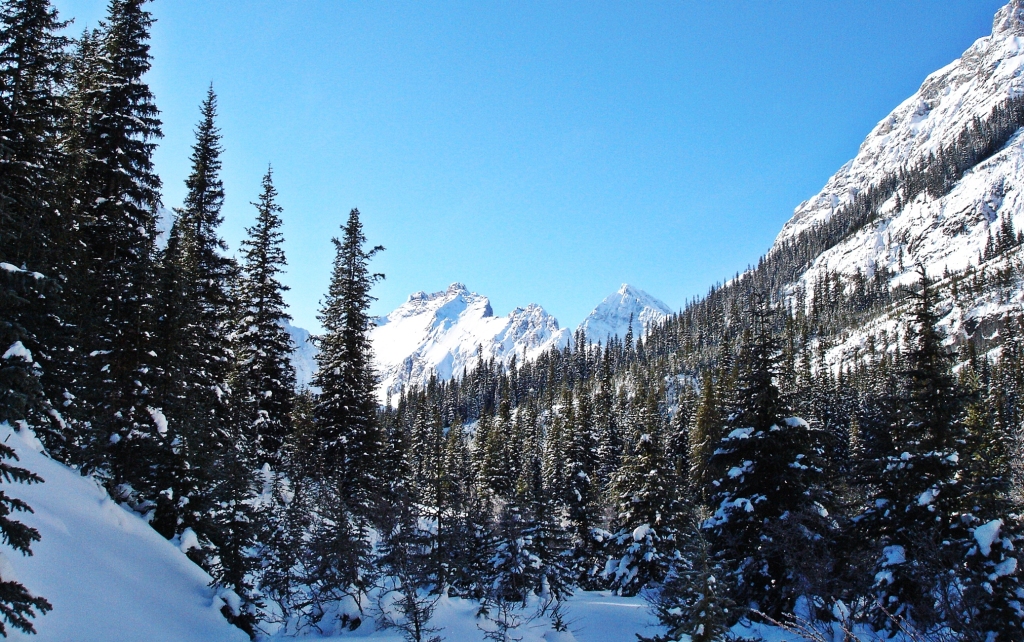
French Creek, French-Robertson Traverse 
French-Robertson Traverse 
French-Robertson Traverse
The terrain in the valley is complicated. You have to negotiate around three waterfalls, a narrow canyon and a few avalanche chutes. We’ve seen avalanche debris cover the ski trail in a few places so always be aware of your surroundings.

Avalanche gully, French-Robertson Traverse 
Avalanche gully, French-Robertson Traverse
The trail finally arrives at a canyon below French Glacier. A steep climb away from the canyon takes you to safer terrain. As you head up the mountain shoulder don’t forget look back for great views toward Mount Chester, The Fortress and Mount Galatea on the other side of the Smith-Dorrien/Spray Trail. In very stable conditions, it’s possible to travel over the boulders at the end of the canyon and approach the glacier from below, but this is not the usual route.

Looking back to Mt. Chester and The Fortress, French-Robertson Traverse 
Looking back to The Fortress, French-Robertson Traverse
After climbing and climbing the trail takes you to the toe of the French Glacier. From here there are two different approaches. One climbs on the left side up to the rocky moraine. Strong winds often strip the snow leaving the ground bare and you may need to remove your skies to cross.
The other option is the longer but gentler path around the right side of a rocky out-crop. The wind often howls down the glacier and it can be very unpleasant. Even with this wind it is still better than taking the moraine. If the visibility is poor here, it is safest to turn around and return to your car. This is a difficult choice, but the safest one. We have had to turn around several times due to poor weather or conditions.

Toward the toe of the French Glacier, French-Robertson Traverse 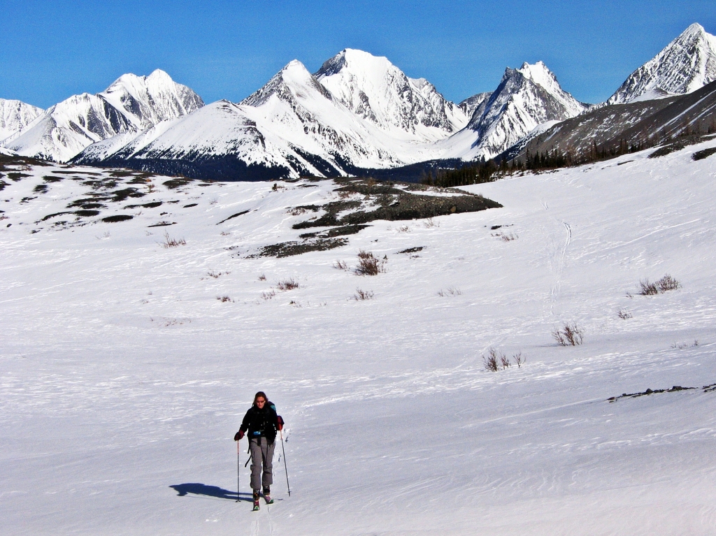
The toe of French Glacier, French-Robertson Traverse
The French Glacier is bordered by the steep couloirs of Mt. French on your left and Mt. Robertson on your right. Behind you, the incredible mountain scenery gets better and better, the higher you climb. These views give you a great excuse to rest so you can turn around and soak in the scenery.
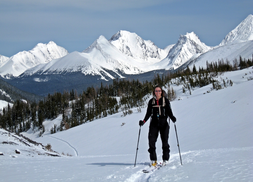
French-Robertson Traverse 
French Glacier, French-Robertson Traverse
After a long slog up the glacier you have to negotiate around a deep, wind-blown moat at the base of Mt. Robertson. After passing it you are on the Haig Glacier and in British Columbia. The weather can be extreme on the glacier. A white-out or winter storm would make it very dangerous to continue. When conditions are good though, this area is breathtaking.
We camped on the Haig one spring in one of the most beautiful spots. We had to go on snowshoes since the snow had mostly melted in the valley. This isn’t a usual snowshoe route and it’s not recommended.

Wind-scoop below Mt Robertson, French Robertson Traverse 
Wind-scoop below Mt Robertson, French Robertson Traverse 
Cold day on Haig Glacier, French-Robertson Traverse 
Haig Glacier, French-Robertson Traverse
The trail continues toward the majestic Mount Sir Douglas. It feels like an eternity, but is really only 1 ½ km to reach the base of Sir Douglas-Robertson Col. This steep 150 m climb to the top is usually wind blown, resulting in either crusty or icy conditions, but if there’s fresh snow it can pose an avalanche risk. We’ve seen this col in many different conditions and the pictures below show how different it can look.
Some skiers try to cut across the col instead of walking straight up. This is dangerous as it crosses avalanche terrain. We’ve frequently seen avalanche debris in this area. If you look closely at the picture below of the pass in rocky conditions, the closest aspect has avalanche debris.

Skiing toward Sir Douglas-Robertson Col, French Robertson Traverse 
Skiing too high on the slope, Sir Douglas-Robertson Col, French-Robertson Traverse 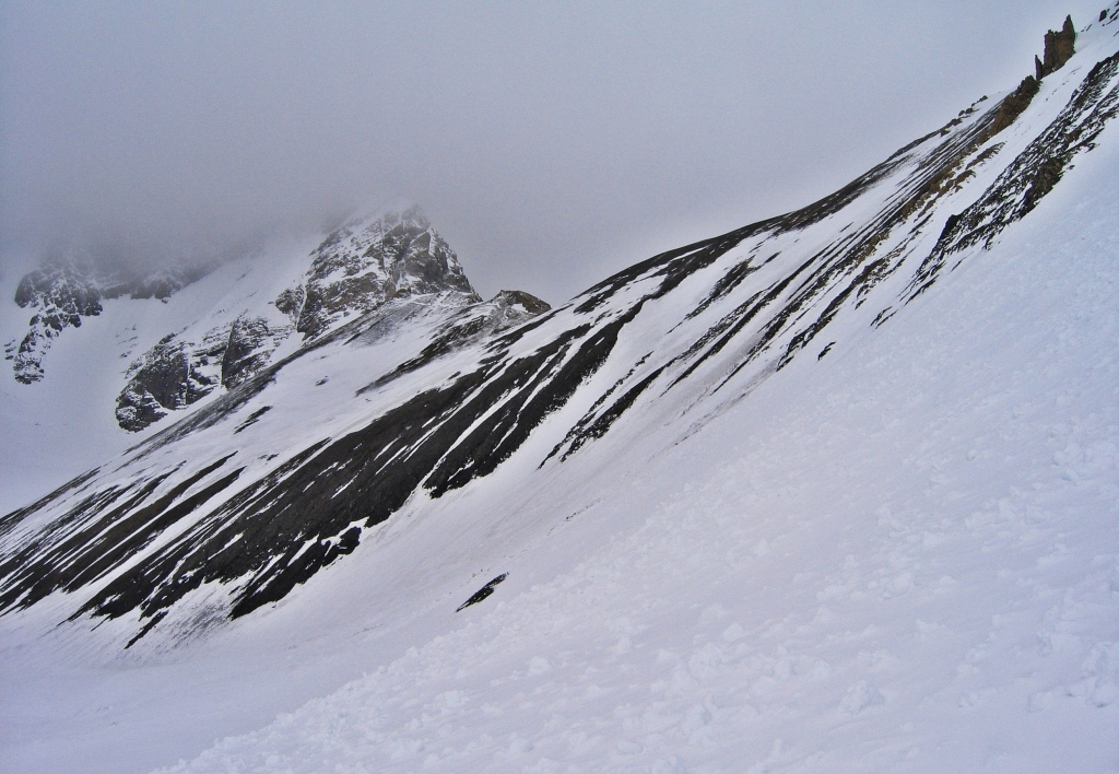
Avalanche debris before a wind-swept Sir Douglas-Robertson Col, French-Robertson Traverse 
Walking up the Sir Douglas-Robertson Col, French Robertson Traverse 
Walking up the Sir Douglas-Robertson Col, French Robertson Traverse
It’s hard work, climbing straight up to the col on foot while your skis are strapped to your backpack. The view from the top though, makes it all worth while. You can see all the way down the gorgeous Robertson Glacier to Burstall Lakes. Looking behind are the impressive mountains of the Kootenays in BC. You are now back in Alberta.

Looking down Robertson Glacier, French-Robertson Traverse 
Looking down Robertson Glacier, French-Robertson Traverse 
On the Sir Douglas-Robertson Col, French-Robertson Traverse 
Sir Douglas-Robertson Col, French Robertson Traverse 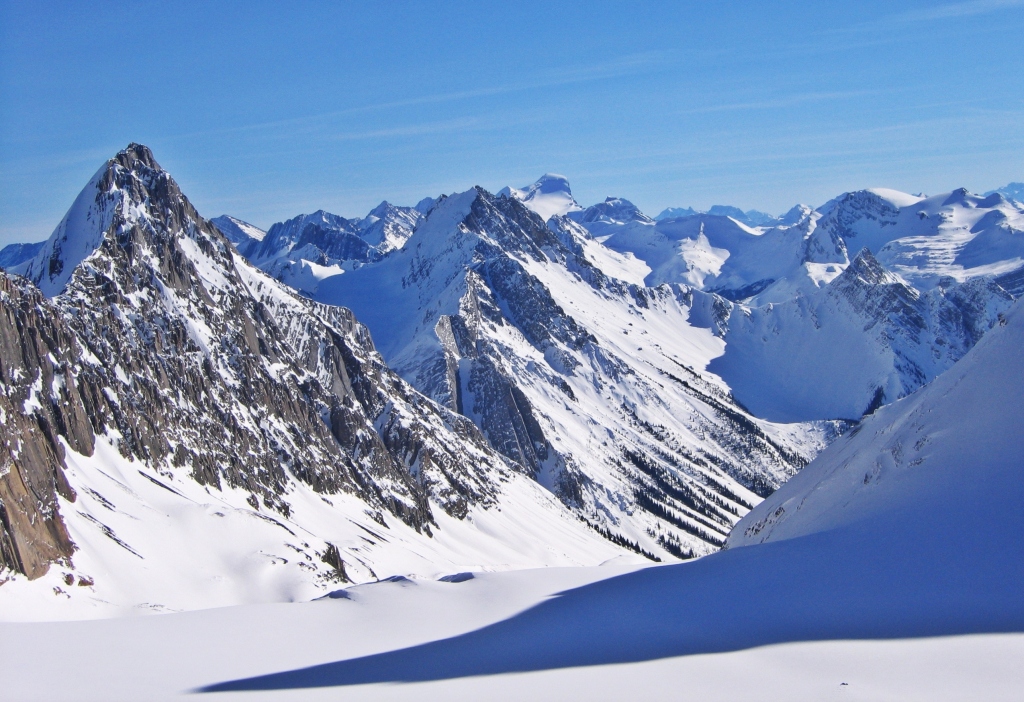
View from Sir Douglas-Robertson Col, French Robertson Traverse
It’s usually very windy here and there is often a cornice on the top so take care where you drop in. The ski down the Robertson Glacier can either be one of your best ski days of the year, or an awful day of survival skiing over cauliflower-like ridges in the wind-swept glacier. There are a few exposed crevasses near the top and bottom. Once you’re on the valley floor there are many avalanche chutes on either side so keep moving quickly until you reach the trees.

Robertson Glacier, French-Robertson Traverse 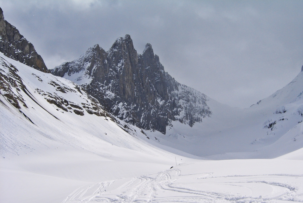
Looking back up Robertson Glacier, French-Robertson Traverse
Once you arrive at the Burstall Lakes don’t forget to look back up as its one of the best views of the Robertson Glacier. The black spires of Mt Robertson and Mt Sir Douglas contrast the white glacier and a blue sky above makes it perfect.
The trail joins the busy Burstall Pass trail. It’s usually easiest to go across the lake and then follow the trail through the trees to the parking lot.

Looking back to Robertson Glacier, French-Robertson Traverse 
Looking back up at Robertson Glacier, French-Robertson Traverse 
Looking back to Robertson Glacier, French-Robertson Traverse
For extra pictures from Canada click here. For pictures from other blogs go to Gallery at monkeystale.ca
To read about more of our adventures go to Destinations.
If you like what you read, please comment or share (with credit) using the links below.

A few calories were burned for these incredible photographs.
LikeLiked by 1 person
Yes, quite a few!
LikeLike
Amazing photos in a beautiful location!
LikeLiked by 1 person
Yes, thank you, this is one of our favourite places to ski
LikeLike
Treasure in Alberta I must say. So I was watching the TV the other day and this ski game came on. The athletes were super fast, they were markings on the ground and the snow wasn’t as thick. I thought whoa! This would be fun but can’t lie, avalanches give me a bit of shiver sometimes.
You sure had fun and skiing is something I’d want to try when I’m much older and more travelled seeing that there’s no snow around me at the moment.
Cheers to more adrenaline pumping adventures!
LikeLiked by 1 person
it’s a lot of fun, and we don’t go nearly as fast as the ski racers! Hopefully you get to try skiing some day:) Maggie
LikeLiked by 1 person
Thanks Maggie.
LikeLiked by 1 person
Beautiful mountain country!
LikeLiked by 1 person
Yes, Alberta has amazing mountain scenery! Thanks for reading!
LikeLiked by 1 person
Fabulous adventure for sure. WE have always loved Kananaskis Country and recall the high winds form our downhill skiing days at Fortress Mountain. Beautiful scenery but not for the faint of heart or weak of knees. Thanks for sharing. Allan
LikeLiked by 1 person
We’ve skied Fortress a few times too, and I think it’s the same wind that just picks up speed as it travels through the park! Maggie
LikeLiked by 1 person
Spectacular shots in inhospitable country! Not for amateurs that’s for sure. I’ve admired this general area from 35,000′ flying from Europe to Seattle.
LikeLiked by 1 person
Thanks, it’s true backcountry for sure:) I love flying from Vancouver to Calgary over the mountains so I’m sure it’s similar to Seattle.
LikeLiked by 1 person
From my recollection of our flight path, I think we flew right over or within a few miles of Kananaskis Country. The scenery was very impressive and prompted me to snap a few photos. Thanks for providing beautiful ground-level views and the fascinating details of your traverse.
LikeLiked by 1 person
Uff…!, Don’t know why, but this post makes me want to learn skiing!.
LikeLiked by 1 person
Yay! You should, it’s so much fun!
LikeLiked by 1 person
Wow! I think my next trip to the Canadian Rockies needs to be in the winter. It’s so beautiful!
LikeLiked by 1 person
It’s incredible, but it’s cold!
LikeLiked by 1 person
Wow, great adventure. The mountains are fantastic.
LikeLiked by 1 person
Thanks, yes, this is a beautiful part of Canada. Maggie
LikeLiked by 1 person
Wow! That sounds like a really cool place to go! I’m trying to learn about some other places to visit in Alberta besides the obvious touristy ones like Jasper and Banff. Do you think it’s also a good place to hike as well as ski?
LikeLiked by 1 person
The hiking in Kananaskis is fantastic. Right now there are a few places you hike closer to Canmore or snowshoe deeper in the mountains. There are great views from the highway (#40) and from the two hotels in Kananaskis Village – you could go for lunch or a hot chocolate and look at the views.
LikeLiked by 1 person
That sounds amazing! I have never done snowshoeing, but I would love to someday! Hopefully, later this winter or maybe next winter, I will be able to go. I have to sort out some legalities about being licensed to drive here as an immigrant. Btw, I am doing a survey about my blog to find out what my readers like and what I can improve. If you don’t mind, I would appreciate it if you could do it. I did a post on it 🙂
LikeLiked by 1 person
Oh, I think I saw it and meant to go back to it. I’ll do it now.
LikeLike
Thank you 😊
LikeLike
Looks like you know all the mountains like your pockets🙂 Breathtaking views!!
LikeLiked by 1 person
Haha yes we know this rea very well 😊
LikeLiked by 1 person
Wow..wow.. Superb !!! A great post as always!
LikeLiked by 1 person
Thank you so much!
LikeLiked by 1 person
thanks for sharing. epic as always! A little less varied in the scenery this time
LikeLiked by 1 person
Thanks Andy, yes, white mountains everywhere 🙂
LikeLike
Beautiful photos!
LikeLiked by 1 person
Thank you 🙂
LikeLike
That looked a lot of hard work, worth it though for those photos!
LikeLiked by 1 person
It was a lot of work but we kept going back so it mustn’t have been too bad 😊
LikeLike
That’s quite the trek in for a skiiing adventure! You mention the avalanche danger…just wondering if you’ve ever caught yourself in a difficult situation with avalanches. I’m curious because I just watched one of the North Shore Search and Rescue shows and it was about the avalanche danger that can occur even here on the local mountains near Vancouver.
LikeLiked by 1 person
We did, and it was terrifying. We were following tracks in very deep snow. They went off route and we stupidly followed for a bit, but breaking trail was so difficult in the deep snow. Anyway, they went into sketchy terrain and we didn’t follow, Very soon after a huge avalanche came down and buried them. We were close enough to search, but they weren’t wearing avalanche beacons so after about 1 1/2 or 2 hours we stopped searching, it was getting dark. Another skier was also close and used SPOT to call for help. A helicopter came after we had turned back. Both men died, it was awful. We’re usually very cautious but since then, even more so.
LikeLike
Yikes! that is scary and so sad! Sounds like much too close for you both as well. Stay safe out there. All the best for the holiday season!
LikeLiked by 1 person
Happy Holidays!
LikeLiked by 1 person
This looks dramatic, peaceful, scary and tough all at the same time. I can imagine the elation and peacefulness of being in the middle of that glorious whiteness. Fantastic photos. I think I better go out and do some exercise now!
LikeLiked by 1 person
It is all of those things! Sometimes all at the same time! The views, especially in winter are fantastic. Have you been to Whistler yet? We’ve been at least 7 day in Kicking Horse already. What a great start of the season, so much snow!
LikeLiked by 1 person
I’ve been to Whistler three times (all mid-week) and have been super impressed with their reservation system and how they’ve organized things. I didn’t encounter any lineups and got in a ton of skiing. A friend told me that the weekends are much busier. Snow is quite good in the alpine but they could use more lower down. We won’t be downhill skiing over the holidays–will wait til the crowds thins in January. I went for a great cross country ski this afternoon at Cypress (local mountain). I was motivated to get some exercise after reading your post! Hope you get in lots more days at Kicking Horse!
LikeLiked by 1 person
What an amazing adventure. I love your winter photos and beautiful mountain views. I used to be pretty good at winter sports, skiing and ice skating including, but ever since I’ve moved to Ireland, my priorities shifted due to the climate. I would love to see if I can stand on the skies without losing my balance and from what it looks like, Canada would be such a perfect place to do it. Thanks for sharing and showing us around. Alberta is truly stunning place. Aiva 🙂 xxx
LikeLiked by 1 person
Thanks Aiva, skiing is like riding a bike, you’ll remember right away! I’m biased but skiing in western Canada is the best! Hopefully you can try it here someday. Maggie
LikeLiked by 1 person
Reblogged this on .
LikeLike