
Looking for a great day hike near Calgary, Alberta? There are so many hikes in the Canadian Rockies to choose from that it is sometimes difficult deciding which one to do. Here are our top 10 hikes in Banff National Park that can be hiked in a day trip from Calgary.
1. Bourgeau Lake and Harvey Pass
The hike to Bourgeau Lake is very popular and for good reason. It’s an easy hike that takes you to a breathtaking view of a mountain lake set in a tight cirque. The first 6 km is relatively flat. It travels through a dense forest slowly gaining 400 m in the first 6 km to reach a nice waterfall.

Waterfall below Bourgeau Lake, Banff National Park
The last 45 minutes is a steady climb to reach the lake 350 m above. Bourgeau Lake has a beautiful setting in a tight amphitheatre formed by Mt. Bourgeau. Depending on the time of year, the meadow before the lake may be filled with wildflowers.

Bourgeau Lake Trail, Banff National Park 
Bourgeau Lake, Banff National Park
If you have the energy to continue, a good trail climbs the slopes above the lake to reach a second cirque formed by Mt. Brett. There are a few alpine tarns in the green, open cirque and you have a good chance to see hoary marmots.

Above Bourgeau Lake, Banff National Park 
Pond above Bourgeau Lake, Banff National Park 
Marmot above Bourgeau Lake, Banff National Park
Continue on the trail as it passes through the cirque heading for Harvey Pass. On the way you’ll pass the small, pretty Harvey Lake. Above the lake is Harvey Pass, formed between Mount Bourgeau and Mount Brett. From the pass you have a great view of the peak of Mount Assiniboine in the distance and in the foreground, a view of Sunshine Village Ski Resort.

Harvey Lake, Banff National Park 
View from Harvey Pass, Banff National Park
Distance – 7.5 km one way to Bourgeau Lake, 9.7 km to Harvey Pass
Elevation Gain – 725 m to Bourgeau Lake, 1020 m to Harvey Pass
Access – There is a parking lot with an outhouse along the Trans-Canada Highway not far from Banff townsite.
2. Larch Valley, Sentinel Pass, Paradise Valley and Mount Temple
Mount Temple is the majestic triangular mountain seen from the Trans-Canada highway and from Lake Louise ski resort. There are a few different options to enjoy the area around Mt. Temple.
Larch Valley to Sentinel Pass – The best time of year to visit Larch Valley is in the fall when the larch trees are a lovely golden colour. But because of this, you’ll be sharing your views with a lot of other hikers. After a climb through the trees you emerge to a large open meadow spotted with larch trees and backdropped by the gorgeous Ten Peaks. As you climb higher the golden larch trees outnumber any other tree and cover the meadow. Many people only make it as far as the valley, but for better views continue up the switchbacks to Sentinel Pass between Mount Temple and Pinnacle Mountain. Beside the pass are the tall, rugged spires called Grand Sentinel.

Larch Valley, Banff National Park 
Larch Valley, Banff National Park 
Larch Valley, Banff National Park 
Larch Valley, Banff National Park 
Sentinel Pass, Banff National Park
If you’re still energetic and are experienced in scrambling, you can get to the summit of Mount Temple. From Sentinel Pass the trail climbs scree slopes, scrambles over a few rock bands and leads up over 800 m to the rocky summit. Do not attempt the summit if there is ice or snow, if it is raining, or if you are not experienced in scrambling. The descent follows the same route. Since it’s the highest peak in the area (3,543 m), you can see most of Banff and Lake Louise from every side.

View from above Sentinel Pass, Banff National Park 
Looking down to Sentinel Pass, Banff National Pass 
View from Mt. Temple Summit, Banff National Park
Larch Valley – Paradise Valley Loop – To get down from Sentinel Pass you can retrace your steps through the Larch Valley or go the other way from the pass through Paradise Valley. The trail immediately drops down through steep rocky terrain to the open meadow below. There are great views of Mount Temple as the trail winds its way around it before going back into the trees. Eventually it connects with the Larch Valley trail which takes you back to the parking lot. The Larch Valley – Paradise Valley Loop can be hiked in either direction.

Paradise Valley, Banff Natinal Park
Distance – 5.8 km one-way to Sentinel Pass, 16 km loop with Paradise Valley, 16 km to Temple Summit return
Elevation Gain – 725 m to Sentinel Pass, 1691 m to Temple summit
Access – The trail head is at the end of the Moraine Lake Parking Area. Depending on the time of year, you may have to park in the overflow parking lot on the Trans-Canada and take the shuttle to Moraine Lake.
3. CORY AND EDITH PASS LOOP
This hike spends most of its time above tree-line allowing you to enjoy the scenery for most of the trek. It’s possible to do this loop in either direction, but we think it’s much easier and more enjoyable to hike in a clockwise direction. After a steep, heart-pounding hike up through an open meadow don’t forget to look back at the amazing views of Vermillion Lakes and Mt. Rundle. After 1 1/2 – 2 hours you reach the crest of Edith’s shoulder and are mostly out of the trees. From here you get your first glimpse of the rugged peaks of Mount Edith and Mount Cory.
The trail now follows a long scree slope to reach Cory Pass. There is one section that requires scrambling, but is not exposed. It’s almost always windy and cool at the pass, but with the spire of Mt. Louis in your view, it’s a nice place for a rest.

Vermillion Lakes and Mt. Rundle from Cory Pass Trail, Banff Natonal Park 
Looking toward Cory Pass, Banff National Park 
Scramblling, Cory Pass Trail, Banff National Park 
Cory Pass Trail, Banff National Park
From the pass you can add in a scramble to the top of Mount Edith. It will add approximately 45 minutes to your day.
From Cory Pass the trail winds around Mount Edith taking you through Gargoyle Valley and closer to the impressive tall spire of Mt. Louis. The sheer limestone walls on Mt. Louis host a number of great technical climbs. If you look closely, you may see climbers high on the wall.
The trail is quite vague as it travels around Mt. Edith so watch for cairns to help you through the boulder field. Once you arrive at Edith Pass, you’ll be back in the trees until you reach your car.


Gargoyle Valley, Banff National Park 
View from Cory Pass, Banff National Park 
Mt. Louis from Cory Pass -Edith Pass Loop, Banff Natonal Park 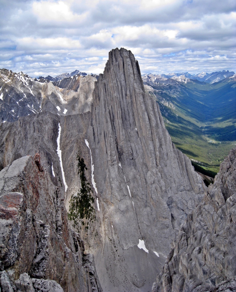
Mt. Louis from Cory Pass -Edith Pass Loop, Banff Natonal Park
Distance – 13 km
Elevation Gain – 915 m
Access – Usually you can park at the Fireside Picnic Parking lot on the Bow Valley Parkway 500 m from the Trans-Canada Highway Junction. The trail leaves from the parking lot for both Cory and Edith Passes. After 1 km of hiking, the turn off for Cory Pass is on the right, the trail continues straight to Edith Pass. Note: in summer 2021 the Bow Valley Parkway is closed so you have to park just off the Trans-Canada and walk an extra 1 km on asphalt to reach the Fireside Picnic parking lot.
4. CASTLE MOUNTAIN
This iconic mountain looks like a castle on a ridge above the Trans-Canada Highway. The long hike to its summit offers breathtaking views along the Bow Valley toward Lake Louise. It begins on an old gravel access road and climbs steeply through the trees. After 5 km or so you can see Eisenhower Tower above and shortly after you reach the small green coloured Tower Lake surrounded by spruce, fir and larch.

Castle Mountain, Banff National Park 
Tower Lake, Castle Mountain, Banff National Park 
Marmot, Castle Mountain, Banff Natonal Park
Continue around the right side of the lake before climbing a steep headwall. Above the headwall you’ll reach Rockbound Lake at the base of Castle Mountain cirque. The lake is aptly named as it is surrounded by large boulders. From the lake’s north shore a faint trail can be seen climbing up to the scree filled bench on the cirque above. It’s a long walk around, slowly increasing in elevation as you go until finally, you’ve reached the end. From the summit you have a bird’s eye view of Eisenhower Tower, which is a spire of Castle, as well as up and down the Bow River.

Rockbound Lake, Castle Mountain, Banff National Park 
Summit, Castle Mountain, Banff National Park 
Below the summit, Castle Mountain,Banff Natonal Park
Distance – 8.4 km one way to Rockbound Lake, 13.5 km to summit
Elevation Gain – 760 m to Rockbound Lake, 1300 m to summit
Access – The parking lot is 200 m east of Castle Junction on the Bow Valley Parkway.
Castle Mountain Fire Lookout – An easy hike climbs the south side of Mount Castle to reach an old fire lookout. Experienced scramblers can continue beyond the lookout to reach Goat Plateau, one of the ledges seen from the Trans-Canada Highway. This route requires scrambling, and is used by climbers to access the Alpine Club of Canada Hut. A rope and harness is needed for the descent.

Goat Plateau, Castle Mountain, Banff Natonal Park 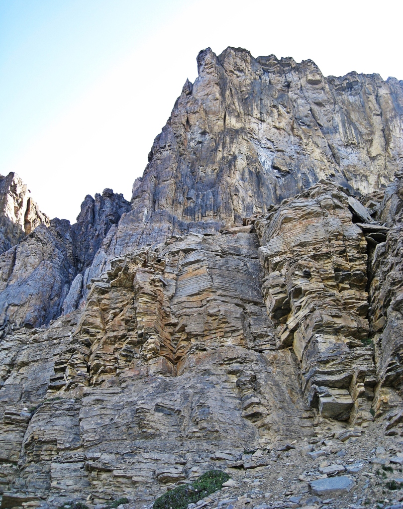
Goat Plateau, Castle Mountain, Banff Natonal Park 
ACC Hut, Castle Mountain, Banff Natonal Park
Access – The trailhead for the Castle Mountain Fire Lookout is a small pullout located on Highway 1A a 5 km west of Castle Junction.
5. Bow Lake to bow Hut
This alpine lake is a popular rest spot along the Icefields Parkway, but also offers a great hike. Snow remains around the lake well into the summer, so either be prepared to hike in snow or plan to do this hike later in August. The trail begins by walking around the pretty Bow Lake. After the lake you arrive at a narrow, rocky canyon guarded by steep cliffs. The winter route goes through the tight canyon, but the summer trail climbs above it on a large moraine. Above the canyon are great views of the hanging Bow Glacier ahead.
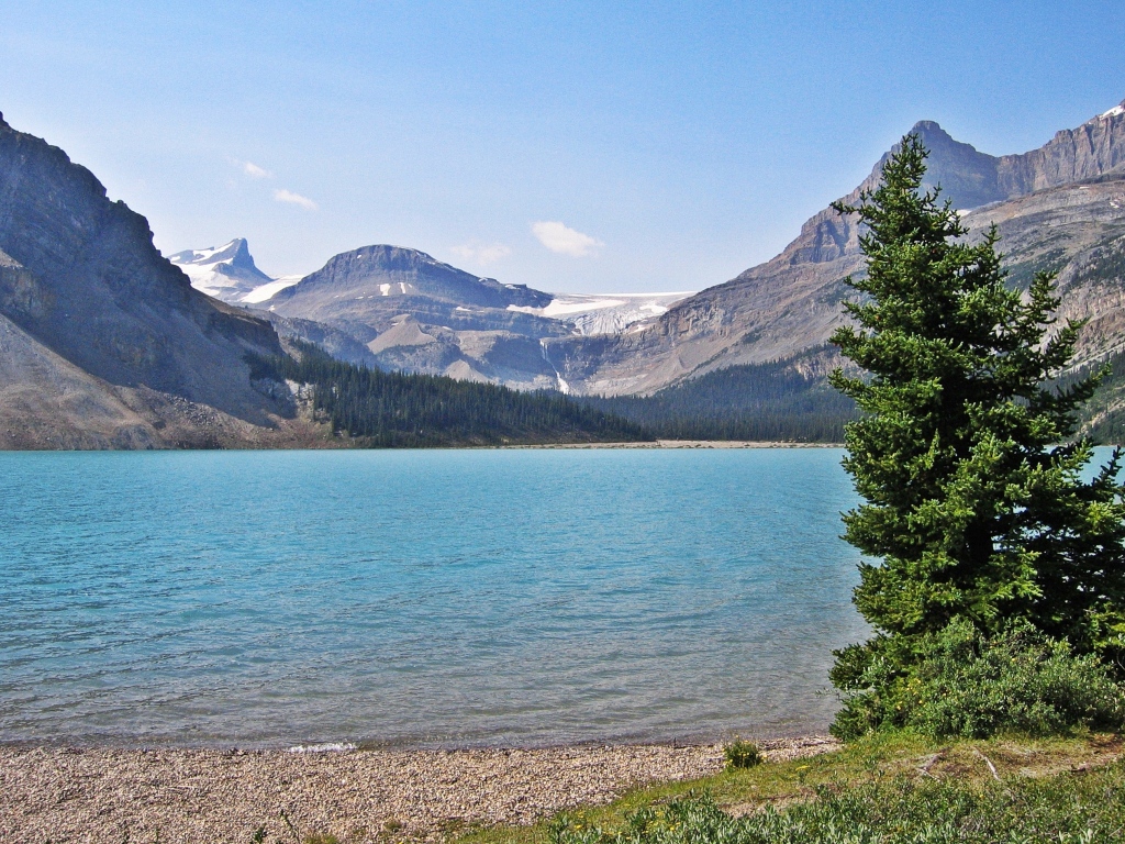
Bow Lake, Banff National Park 
St. Nicholas from Bow Lake, Banff National Park 
Bow Canyon, Banff National Park
After walking along the ridge for a while the views open up and you can see Bow Hut perched up high above on the morraine. The trail follows the lower morraine until you’re under the hut and then has a steep hike up the ridge. The views from the hut toward the Dolomites and Mt. Crowfoot are spectacular. If you’re energetic you can continue to hike up the hut to the toe of the Wapta Glacier.

Below Bow Hut, Banff National Park
Distance – 9.8 km one way
Elevation Gain – 714 m
Access – Park in the Bow Lake Parking Lot beside Num Ti Jah Lodge on the Icefields Parkway (Highway 93). The trail begins on the other side of the lodge.
6. HELEN LAKE AND DOLOMITE PASS
This hike is popular in both summer and winter. Leaving the Helen Lake trailhead the route quckly climbs through the trees with a couple of nice lookouts of Crowfoot Glacier. Helen Lake is a small pretty lake surrounded by talus slopes. It’s a great place for a rest.

Bow Lake and Crowfoot Glacier, Banff National Park 
Helen Lake, Banff National Park
If you wish to continue, a steep series of switchbacks climbs above Helen Lake to a ridge. This is actually the high point of the hike and offers great views of Katherine Lake and across the highway to the Waputik mountains. Katherine Lake is actually nicer than Helen, but most people don’t bother to hike up to it. If you continue beyond Katherine Lake, the trail descends to Dolomite Pass. It’s a wide open grassy pass with amazing view of the ragged peaks of Dolomite Peak. This is the view of the mountain that reminded early mountaineers of the Dolomites in Italy.

Katherine Lake, Banff National Park 
Cirque Peak, Banff National Park 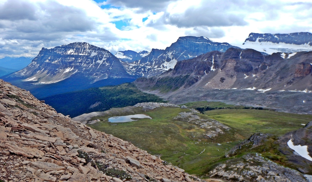
View from Dolomite Pass, Banff National Park 
Below Dolomite Pass, Banff National Park
Distance – 6 km one way to Helen Lake, 8.9 km to Dolomite Pass
Elevation Gain – 455 m to Helen Lake, 550 m to high point before Dolomite Pass
Access – There is parking in a small lot on the the Icefields Parkway on the opposite side of the highway to the trail head. This lot is 5 km north of Mosquito Creek parking lot.
7. MOSQUITO CREEK TO NORTH MOLAR PASS
The first seven kilometres of this hike follow Mosquito Creek through the trees before emerging onto the gorgeous Molar Meadows. This vast area is backdropped by the impressive Dolomite Peak.
The beauty of this meadow is overwhelming. Rolling hills slowly lead up to North Molar Pass (2,590 m) with spectacular views of the meadow behind you as you climb. The final push up to the pass is steep and depending on the year, is often snow covered and can be impassable so check the route conditions before heading out.

Molar Meadow, Banff National Park 
Molar Meadow, Banff National Park 
North Molar Pass, Banff National Park 
Dolomite Peak and Molar Meadows, Banff National Park
Distance – 11.5 km one way
Elevation Gain – 760 m
Access – Park in the Mosquito Creek parking lot on the Icefields Parkway (Hwy 93), 24 km north of Lake Louise.
8. NIGEL PASS
The hike begins at the trailhead for Nigel Pass in Banff National Park, just before its border with Jasper National Park. It is a gentle climb that first takes you through a spruce and fir forest. Higher up, you walk through meadows filled with low shrubs allowing you to enjoy the surrounding peaks. Nigel Pass is a large open area covered in smooth limestone rocks and offers spectacular views of the wide Brazeau River Valley in front and as far as Mt. Saskatchewan behind.

Nigel Pass Trail, Banff National Park 
Nigel Pass Trail, Banff National Park 
Looking toward Mt. Saskatchewan, Nigel Pass, Banff National Park 
Leaving Nigel Pass, Banff National Park
Distance – 15.5 km round trip
Elevation Gain – 317 m
Access – Park at the Nigel Pass trailhead which is 2 1/2 km north of the Big Bend switchbacks on the Icefields Parkway (Hwy 93)
9. Cascade Mountain
Looking down Banff Avenue in Banff town, Mt. Cascade appears to be right at the end of the street. There are technical climbing routes on the front and a long hike to the summit on the mountain’s backside. After passing through Mount Noquay Ski Resort the trail begins to climb the west ridge of Cascade. Don’t forget to look behind on occasion where you have terrific views of Mt. Louis and Mt. Edith. There are a few steep switchbacks that end at the Cascade Amphitheatre. This large cirque is beautiful with an open meadow closed in by the tall ridge of Cascade and is home to marmots and pikas. Many people stop at the amphitheatre as the next section to the summit is more challenging

Marmot, Cascade Mountain, Banff National Park 
Cascade Mountain, Banff National Park
From the amphitheatre basin you can see the First Peak, False Summit and the Main Summit far above. Getting to the summit involves a few sections of scrambling and exposed terrain so if you’re not experienced, you should not go further. Negotiating around the False Summit takes a bit of route finding,so read up in one of the many hiking trail books available. Do not attempt to go beyond the amphitheatre if there is snow or ice.
Upon reaching the summit you are rewarded with open views of Bow Valley including Mt. Rundle, Lake Minnewanka and Mt. Aylmer in front, Banff town to the south and majestic Mt Louis and Edith behind.

View from Cascade Mountain, Banff National Park 
Lake Minnewanka from Cascade Mountiain, Banff National Park
Distance – 7.4 km one way to amphitheatre, 9 km to the summit
Elevation Gain – 610 m to amphitheatre, 1460 m to the summit
Access – Park in the Mount Norquay Ski Resort, the trail begins beyond Mystic Chair.
10. Boulder Pass and Deception pass
Most people think of Skoki as a winter destination, but this area has incredible scenery in the summer too. It’s reached from the top of the ski out road at Lake Louise Ski Resort near Larch Chair. The trail skirts along the side of the resort before climbing up toward Boulder Pass. The name is well suited as it is an open area filled with large boulders in all possible shapes and sizes.
After the pass, the trail follows around Ptarmagan Lake before reaching the base of Deception Pass. Climbing to the top of the pass is a steep, climb over loose ball-bearing like gravel to the top of the pass so watch your footing on the way down. From Deception Pass you can walk down to see the amazing Skoki Lakes.

Boulder Pass, Banff National Park 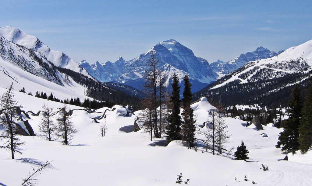
Mt. Temple and Boulder Pass during winter, Banff National Park 
Ptarmigan Lake, Banff National Park 
Skoki Lakes, Banff National Park
Distance – 4 km road to resort, 8.6 km to Boulder Pass, 11 km to Deception Pass
Elevation Gain – 640 m to Boulder Pass, 785 m to Deception Pass
Access – Park in the Mount Norquay Ski Area, the trail begins beyond Mystic Chair.
Hiking Tips in the Canadian Rockies
- Expect sudden changes in weather. Bring a rain jacket, an extra sweater, gloves and a toque.
- Hiking poles are useful in many areas and can help save your knees when going down steep descents.
- Bring enough water. Many hikes do not have fresh water sources on the trail.
- Bring bear spray and/or bear bangers and educate yourself on wildlife safety.
- Don’t forget the usual – good hiking shoes, bug spray, sunscreen, snacks.
Coming Next – Our Great Canadian Road Trip
To see more of our pictures from around the world visit our Gallery.
For more of our stories from around the world visit Destinations.
If you like what you read please share, with credit, using one of the links below.

Oh goodness, I don’t know how you ever managed to narrow this list down to only ten! But wow, ten incredible hikes! I was going to choose a favorite but I can’t, they all just look so beautiful. I’ve gotta get back to the Canadian Rockies sometime soon… and now I have an excellent to-do list thanks to this post 😊
LikeLiked by 2 people
Thanks Diana! It is anamazing place to hike and it was hard to narrow the list. I’m sure some people have other favourites and may disagree. Hope you hike here soon!!
LikeLiked by 1 person
These landscapes are so stunning!! Great images!
LikeLiked by 1 person
Thanks Colin! I see you have released a few posts lately. Werecamping our way across Canada so my internet access is limited. I have. a lot of catching up to do. Maggie
LikeLiked by 1 person
Haha, how wonderful! Hope you are having a great time! Any connection to the internet while out in the real wilderness is amazing. Just makes you wonder how remote you have to be to be genuinely incommunicado these day! 😉
Stay safe! 🙂
LikeLiked by 1 person
Some incredible hikes Maggie. Nothing beats a walk/hike in the mountains. Love the shots of Larch Valley in the fall. Can’t wait to see the tamaracks in our little Bunchberry Meadows hike when they turn colour. Thanks for sharing. Have a great week. Allan
LikeLiked by 1 person
Thanks Allan, Larch Valley is one of the most popular hikes and for good reason. On a clear day the golden larch are gorgeous. Maggie
LikeLiked by 1 person
Oh wow! You were not kidding when you’ve mentioned right at the start that there are many hikes in the Canadian Rockies … the scenery of all these hikes are just spectacular! The combination of the mountains and lakes are really beautiful – amazing photo’s!!
LikeLiked by 1 person
Thanks! We are lucky to live in such close range of these amazing views 😊
LikeLiked by 1 person
Bookmarking!!!!
LikeLiked by 1 person
😊
LikeLiked by 1 person
Wow, just look at all the wonderful hikes! Known for its massive Stampede and its proximity to the Canadian Rockies, Calgary is a beautiful city that’s perfect for outdoor lovers. But as we only had a day in the city, we didn’t get to go on any hikes. I would love to return one day to explore the great outdoors, especially in the fall when the trees change colour. Thanks for sharing and have a nice day, Maggie 🙂 Aiva xx
LikeLiked by 1 person
Yes Aiva the Stampede marketing often overshadows the best part of Calgary, its access to the Rockies. Thanks for reading! MaggieKayes
LikeLiked by 1 person
Thank you so much for sharing these beautiful hikes and photos! I’m now itching to go to Banff!
LikeLiked by 1 person
I hope you get there!!
LikeLike
Thank you! Fingers crossed it will be this year! 🤞
LikeLike
OMG, so many amazing options; I’d like to do them all. Larch Valley-Sentinel Pass-Temple looks especially appealing to me. Those spires are very cool. Thanks for all this excellent intel.
LikeLiked by 1 person
Your sister has probably done many of them. You’d love Larch Valley or Paradise in the fall..
LikeLike
Wow..wow… Awesome!!! Stunning views around every corner of Banff!! Its so beautiful!!! Thanks for sharing Maggie! Hope to visit Banff someday 🙂
LikeLiked by 1 person
Thanks Jyothi, itsan amazing part of Canada. Hope you get there someday! Maggie
LikeLiked by 1 person
Tower Lake and Bow Canyon are calling to me. I think you should approach the Canadian tourist centre with these and do a deal. Stunning place. One day I’d like to see it.
LikeLiked by 1 person
Thanks! Yes I’m planning on sending to the tourism board, let’s see if they bite 😊 Maggie
LikeLike
Oh wow, what an amazing post. I particularly like Bourgeau Lake and Dolomite Pass…and the Marmot of course 🙂 I really must come and visit Banff one day soon!
LikeLiked by 1 person
Thanks Hannah! It’s a gorgeous part of Canada, keep it on your must-see lis t😊
LikeLiked by 1 person
These look like such incredible hikes. I’ve been to Banff three times and there are still so many trails left to explore. Larch Valley looks breathtaking in the the fall.
LikeLiked by 1 person
Larch is incredible in the fall, but also very busy. Did you hike when you were in Banff?
LikeLiked by 1 person
I sure did. One of my most favourite trails in Banff was when I hiked to the tea house at Lake Agnes then up Big Beehive to get to the other tea house at Plain of the Six Glaciers.
LikeLiked by 1 person
That’s a gorgeous one too 😊
LikeLiked by 1 person
Astoundingly beautiful pictures. I’m at a loss of words totally. What a fascinating hike it would have been.
LikeLiked by 1 person
Thanks Neel, it’s a gorgeous place to hike.
LikeLiked by 1 person
What a wonderful collection of hikes in that area. Oh those views!…from either the bottom or the top it’s all so just breath-taking!
LikeLiked by 1 person
It really is a breathtaking part of the country.
LikeLiked by 1 person
Looks like you live in a perfect place for hiking!
LikeLiked by 1 person
It is and the trails are usually empty because there are more choices than hikers!
LikeLike
The only advantage of the pandemic is preventing hordes of tourists from going places.
LikeLike
Now I must return to Banff. It’s been too many years since the last visit. Thank you for the majestic photos.
LikeLiked by 1 person
Thanks! Banff is a true Canadian gem 😊
LikeLike
Somehow, I always feel that among all countries, Canada is one the most beautiful and huge. Norway, Switzerland, etc. are beautiful as well, but Canada is a huge country that is sparsely populated.
LikeLiked by 1 person
That’s true it is large with a small population. We’re currently on a road trip across Canada and it’s a great reminder how much wilderness we have.
LikeLiked by 1 person
You are a lucky person, Maggie 🙂
LikeLike
These look like great hikes, fabulous photos Maggie,love the marmot too 😁
LikeLiked by 1 person
Thanks! The marmot are always so cute😊
LikeLike
More amazingness that I can only dream about. How do you navigate on these paths? Are they waymarked? Or is it ye olde map and compass? Ta Mel
LikeLiked by 1 person
These hikes are all in a national park so are good paths, easy to follow with signs and route markers.
LikeLiked by 1 person
Such scenic locations and some stunning pictures… You definitely had an amazing hike.
LikeLiked by 1 person
Thanks it is a beautiful part of Canada.
LikeLiked by 1 person
Wow. These hiking areas are just gorgeous. So many different shapes and rock formations. The scramble looks fun (it always does when I’m looking at it from a chair with a coffee next to me . . . not so much when I’m doing it). In the picture you are grabbing onto a chain or rail of some kind. Is that permanent or did you install something temporary a la rock climbing?
LikeLiked by 1 person
I think my hiking poles are in my hand but some have chains permanently installed. It is a great place to hike as well a lot of people bike the Bow Valley Parkway between Banff and Castle Mountain. Maybe a future trip!
LikeLiked by 1 person
Maybe . . . I recently discovered the circular Canadian scenic train route that can start and end in Vancouver and takes in Banff and Jasper. That’s also a definite maybe . . .
LikeLike
Stunning photos, gorgeous mountain-scapes. Loved the marmot!
LikeLiked by 1 person
Thanks, it’s a gorgeous part of the country. And the marmots are always so fun to see.
LikeLiked by 1 person
What incredible hikes in one of the most beautiful locations in the world. So many stunning views in every direction and your photos are fantastic. We loved Banff National Park but didn’t get anywhere near any of these wonderful locations.
LikeLiked by 1 person
Thank you, Banff is one of the most beautiful parks and we’re lucky to live so close to it.
LikeLike
The beauty in these photos capture ones wildest imagination. This makes me want to get out there and rediscover the beauty here in Washington!
Thank you for sharing this.
LikeLiked by 1 person
Thanks for reading! You must have a lot of similar spots in Washington. Maggie
LikeLiked by 1 person
Fond memories of this area
LikeLiked by 1 person
It’s a gorgeous part of Canada, glad you got to visit.
LikeLike
Reblogged this on .
LikeLiked by 1 person
Thanks!!
LikeLike
welcome 🙂
LikeLike
Nature at its best wow
LikeLiked by 1 person
It’s a gorgeous area. Thanks for reading, Maggie
LikeLike
Great images of Banff..you had great time there.
LikeLike
Such amazing hikes Maggie! We didn’t really have time to hike on our visit in the area, several years ago, and still dreaming to be able to do some of these trails on our next visit there.
LikeLiked by 1 person
There’s much great hiking in this area I hope you get a chance to come back 😊
LikeLiked by 1 person
It is certainly on my list to go back one day😊
LikeLike
Great post. Places are worth visiting. Appreciated.
LikeLiked by 1 person
Thank you!
LikeLike
Awww I love marmots!!
LikeLiked by 1 person
So do we! 😊
LikeLike