
The circuit hike between Chester Lake and Headwall Lakes is a great day trek from Calgary that takes you to 3 gorgeous mountain lakes. An excellent option is to include a side trip up to the summit of The Fortress. The route offers awesome views along the way but the penultimate view is from The Fortress summit where you can see Mount Assiniboine, Mount Joffre and Haig Glacier. These views are one of the reasons this hike is one of our Top 10 Day-Hikes From Calgary.
The loop hike can be done in either direction, but we’ll describe it in a clockwise direction.
Distance – 19.2 km (12 miles)
Elevation gain – 1,162 m (3,812 ft)
Access – Chester Lake Parking Lot, Smith-Dorrien/Spray Lakes Trail
From Chester Lake Parking Lot the trail initially follows an old logging road. There aren’t many views and it isn’t an encouraging start. Soon though, the trail changes to a proper dirt hiking trail that winds its way through the tight forest, slowly gaining elevation. Finally you’ll reach an open meadow below the imposing Mount Chester. From here you begin to get a glimpse of the views to come.


After crossing the meadow the small but picturesque Chester Lake comes into view. Bordered by the impressive Mount Chester, the lake has a lovely setting. Since the hike to Chester Lake is only 5.5 km and 330 m elevation gain, it is a popular day hike. Not as many people travel much beyond the lake so even if it’s busy at the lake, don’t worry, you’ll soon be on your own.


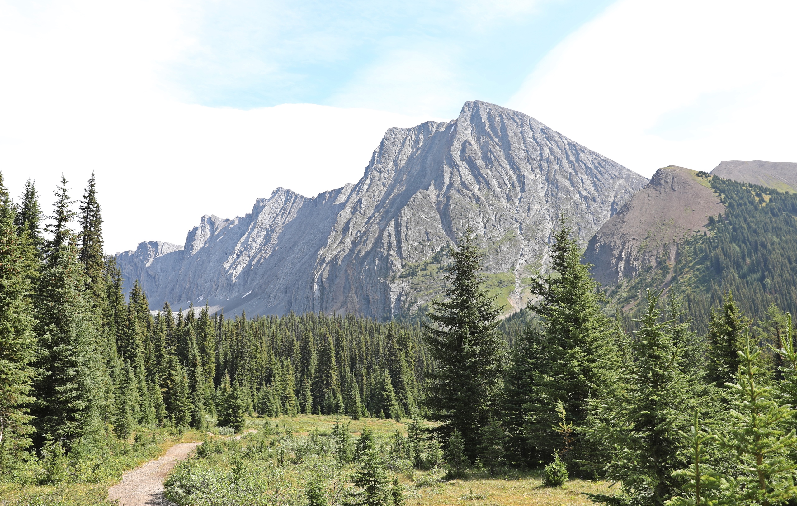
From the lake you can just see the tip of The Fortress in the distance. To reach the pass between Mount Chester and The Fortress continue to walk around the east edge of the lake until the trail begins to climb through the trees. At the edge of the trees the trail traverses the undulating moraine above Chester Lake. As you ascend look behind for improving views toward Haig Glacier. Eventually you will reach a large, open, flat moraine and soon you can see the col between The Fortress and Mount Chester. This is your next objective.


The steep hike up the headwall to the col is a 140 m grind offering little reprieve from the climb. Once at the top, look down to see the valley that contains Headwall Lakes. The weather often changes quickly in this area so if it’s not a clear day you may want to consider turning around or heading straight down to Headwall Lakes instead of attempting to summit The Fortress.


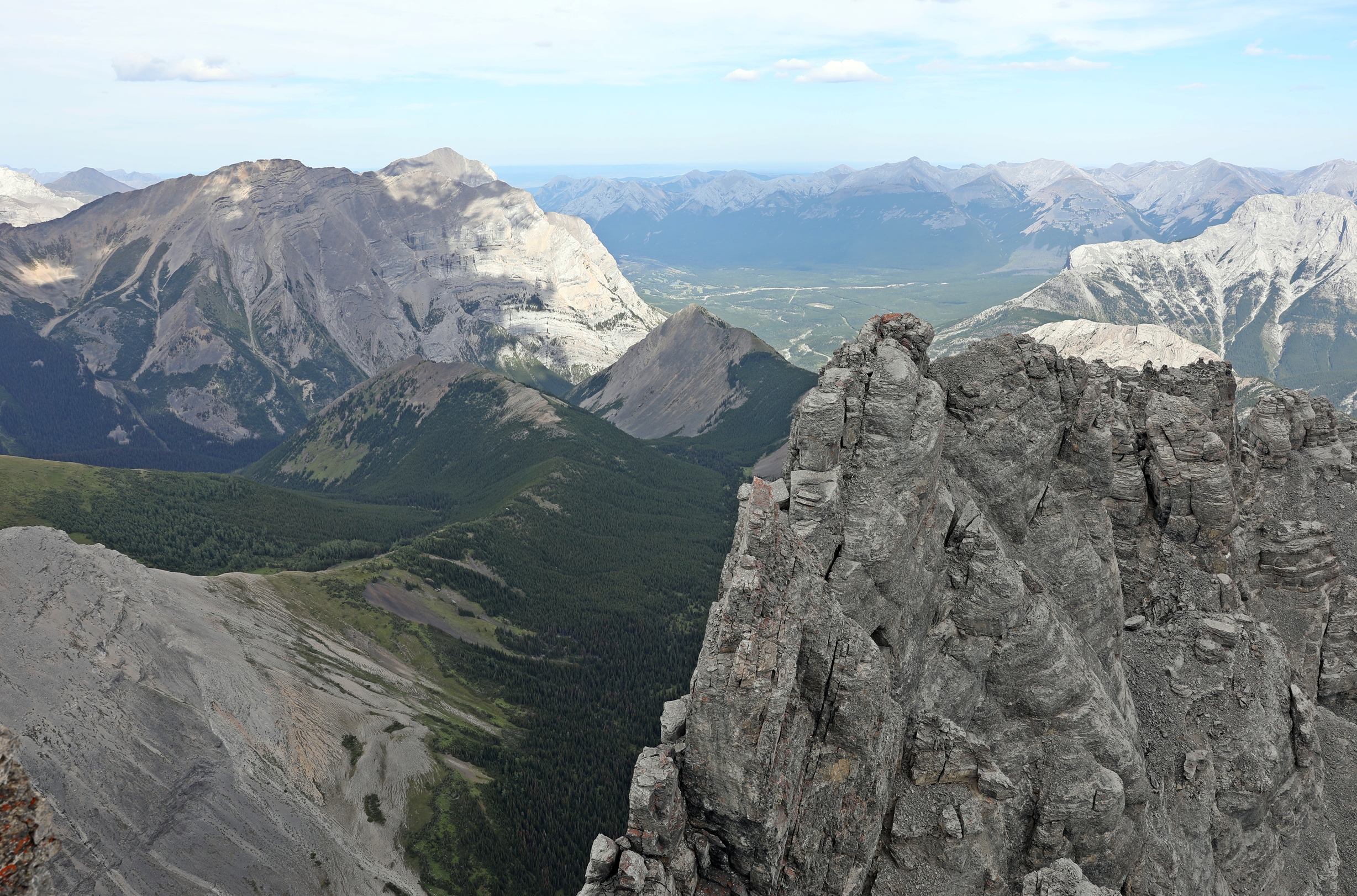
If the weather is good, continue up toward The Fortress summit, approximately 200 meters above. The steep trail to the summit is on ball-bearing scree that follows the ridge. Don’t forget to look back occasionally for views of Chester Lake and across the highway to Haig Glacier.
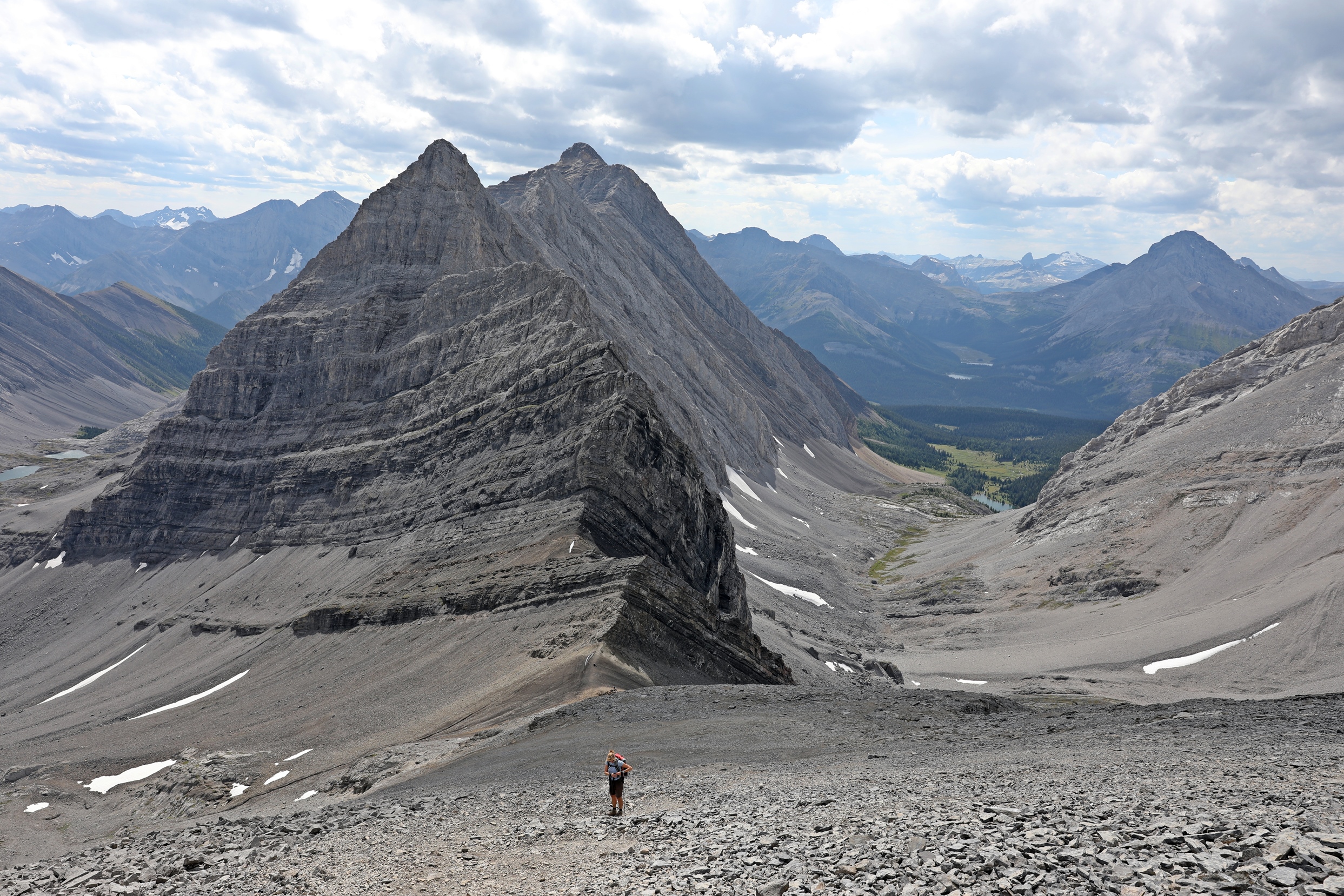

The final ascent is a scramble over a small but exposed rock band. It is not difficult, but it does require a scramble using hands and feet. From the top, the 360 views of Kananaskis Country are awesome. On a clear day you can see the top of Mount Assiniboine, soaring high above the others.


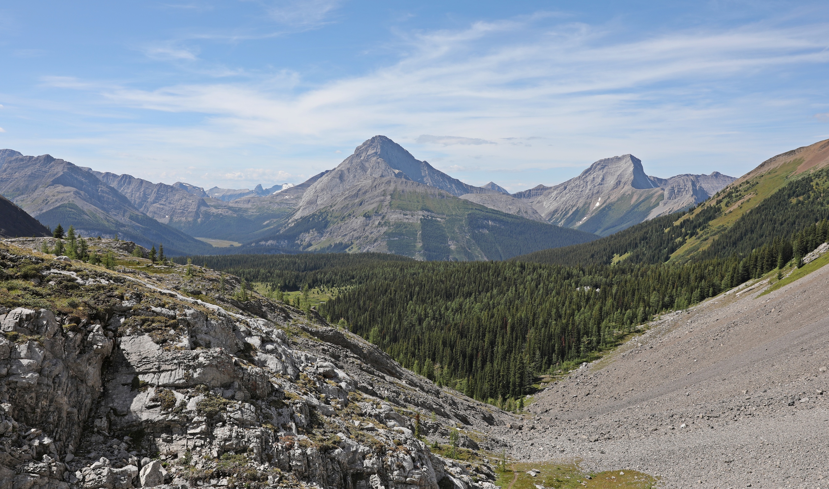
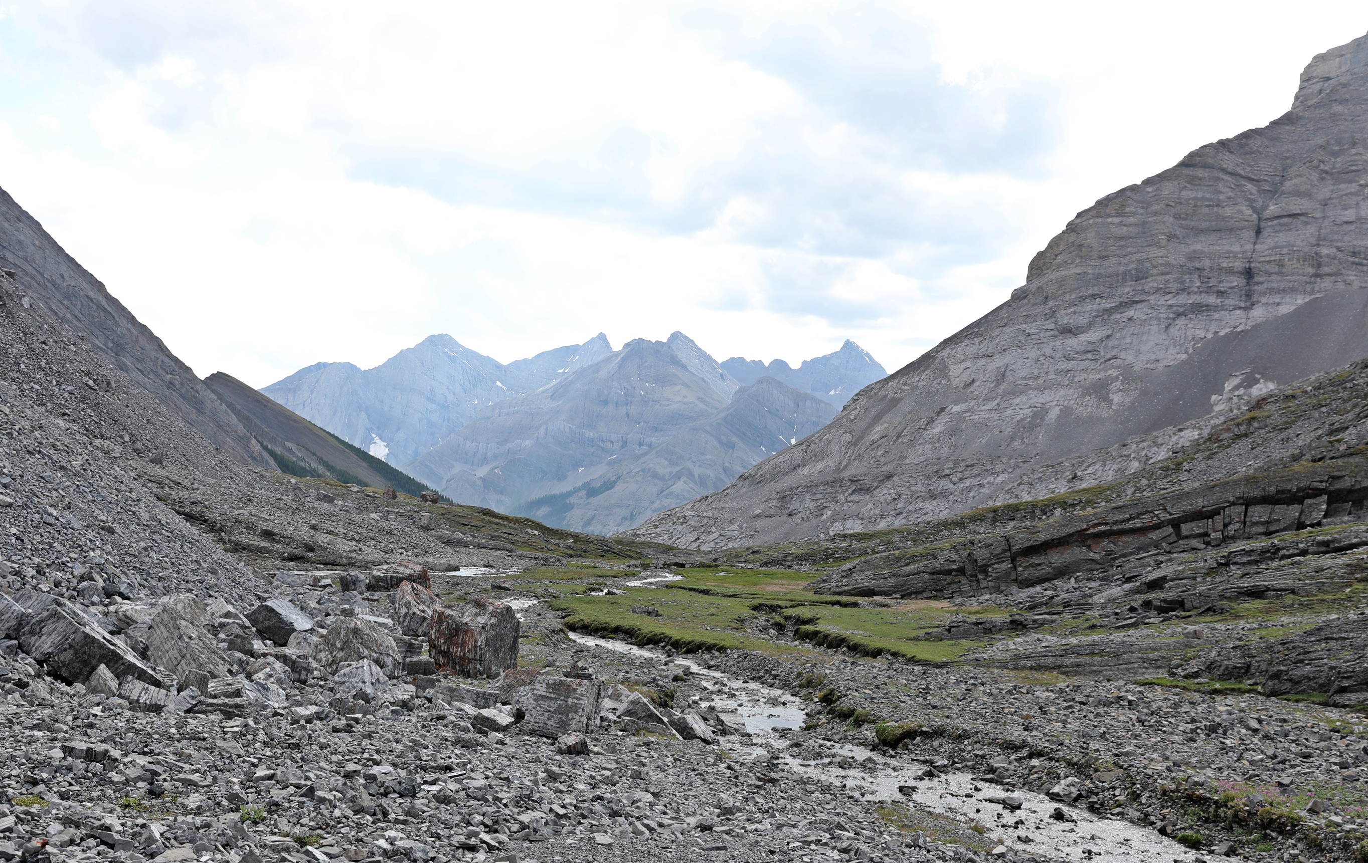
Descend on the same path back to the col between Mount Chester and The Fortress. Hiking poles are very helpful here as you go down the steep trail on ball bearing-like rocks. From the col you could return to Chester Lake, but we suggest you make it a loop and go down the other side of the col to Headwall Lakes. This side of the headwall is similar to the Chester Lake side with loose scree and a steep slope.
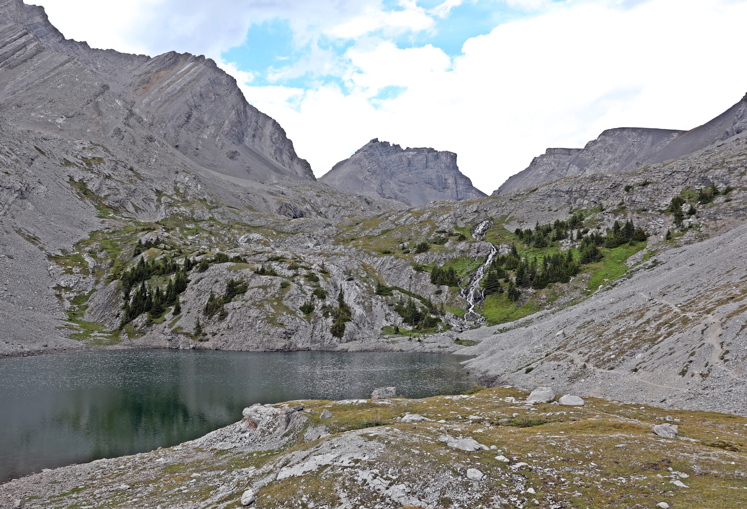
From the bottom you can see a good trail that leads through the valley. It slowly but consistently descends to reach the highest Headwall Lake with the opposite side of Mount Chester on its edge. Behind you the distinctive peak of The Fortress stands proud.


Continue passed the upper Headwall Lake for another 10 minutes to reach the lower lake. The two lakes look very similar, except for the small waterfall at the end of the lower lake. Before leaving the lower lake, look back for your final view of The Fortress.


From the lower lake, you have to lose most of the remaining 472 meters elevation in a short distance. If it has recently rained, the trail will be very muddy and slippery as it quickly descends between trees and down rocky ledges. After a knee jarring descent you finally reach flatter ground and a good trail that takes you to an old logging road. Easy, although monotonous, walking for the final 3.2 km take you to your car at Chester Lake Parking Lot.

Tips for hiking in the Canadian Rockies
• Expect sudden changes in weather. Bring a rain jacket, an extra sweater, gloves and a toque for one-day or multi-day hikes.
• Hiking poles are useful in many areas and can help save your knees when going down steep descents.
• Water taken from streams will need to be treated, filtered or boiled
• Bring bear spray and/or bear bangers and educate yourself on wildlife safety.
• You will need to purchase a Kananaskis Conservation Pass.
For more hikes in the Canadian Rockies go to Treks.
Coming Next: What to do in Calgary this Summer
For extra pictures from Canada click here. For pictures from other blogs go to Gallery at monkeystale.ca
To read about other hikes go to Treks. To read more of our adventures from around the world go to Destinations.
If you like what you read, please comment or share (with credit) using the links below.

All of your photos are magnificent. I especially enjoy the views from the meadows and the lake.
LikeLiked by 1 person
Thank you, those views are why the hike the Chester is so popular. 😊 Maggie
LikeLiked by 1 person
Absolutely stunning. Those grinding ascents and knee-jarring decents were obviously worth it.
LikeLiked by 1 person
They were, the views at the top are awesome 😊 Thanks for your kind comments! Maggie
LikeLiked by 1 person
Beautiful
LikeLiked by 1 person
Thank you 😊
LikeLike
Have to send that to my relatives, who live in Alberta!
LikeLiked by 1 person
Where do they live?
LikeLike
Wow, such stunning mountain and lake views, Maggie 🙂 while many usually rush to trek in Banff and Jasper, Kananaskis looks equally worthy and should not be overlooked. Thanks for sharing and have a good day 🙂 Aiva xx
LikeLiked by 1 person
Kananaskis is often overlooked by tourists, but Calgarians love it. Thanks for your comments Aiva! Maggie
LikeLiked by 1 person
What a picturesque adventure you described so well. I was hooked from the first sentence of this adventure! Breathtaking photos!
LikeLiked by 1 person
Thanks Suzette!! I really appreciate your kind words 😊 Maggie
LikeLike
My sincere pleasure. Have a lovely day! Cheers.
LikeLike
Truly magnificent. Thank you 😊🌍
LikeLiked by 1 person
Thank you!! Maggie
LikeLiked by 1 person
You are welcome 😊🌍
LikeLike
an impressive landscape, thanks for showing.
LikeLiked by 1 person
Thank you Richard, it is a beautiful part of Alberta 😊 Maggie
LikeLiked by 1 person
Another spectacular hike Maggie. The views are indeed spectacular. I agree with you on the use of hiking poles. I developed a new appreciation for them on my Citadel Pass backcountry hike. Thanks for sharing and Happy Wednesday. Allan
LikeLiked by 1 person
Yes I always use them on the descent. They’ve saved my knees a lot of wear and tear. 😊 Thanks for reading Allan, Maggie
LikeLiked by 1 person
What wonderful mountain scenery! Not a hike I would feel able to do, so I enjoyed my virtual version all the more 😀
LikeLiked by 2 people
Thanks for coming along on the hike today Sarah! Maggie
LikeLiked by 1 person
Breathtaking views!! Although I’m not sure if I would be able to scramble to these kind of summits, I would definitely like to try them🙂
Are the trails marked well? I mean for the outsiders which are not familiar with this area
Christie
LikeLiked by 1 person
The hike to Chester Lake and Headwall Lakes are marked quite well but the section on the moraine and up the headwall between them is not marked. If you know generally where you’re going it’s not difficult to figure out, but this section is not really a maintained trail. Maggie
LikeLiked by 1 person
I mean wow, these views are absolutely STUNNING. Thank you for taking me on this hike with you 🙂
LikeLiked by 1 person
Thanks for coming Hannah! It is a beautiful trek, glad you like it 😊 Maggie
LikeLike
This reminds me of the Kashmir great lakes trek which takes through some of the most pristine lakes in the Himalayan region. If you ever find time, just google this trek.
LikeLiked by 1 person
Yes we did the Great Lakes Trek 3 years ago! It reminded us a lot of Kananaskis, where this Chester Lake trek. 😊😊
LikeLike
Great. Good to know you have already done this trek, Maggie 😊
LikeLike
Fabulous. The terrain and the views are special.
LikeLike
Oh my, what stunning places; mountains, lakes, who could resist hiking in these beautiful areas?
LikeLike
Thank you for sharing! Duly noted on my to-do list for the next time I am in the area!
LikeLiked by 1 person
You would love it!!
LikeLiked by 1 person
Oh, wow! That’s hiking for you 🤗💟
LikeLiked by 1 person
It is so nice of mother nature to heave up giant slabs of rock that leave us with awe inspiring views and places to challenge our physical and mental abilities.
Thanks for sharing your experience!
LikeLiked by 1 person
Mother Nature is very good at making these amazing views for us. 😊
LikeLike
Majestic views and subtle warnings (knee jarring descent). Bear spray just has me thinking all manner of things.
LikeLiked by 1 person
Yes there’s a bit of suffering for the views 😊 Maggie
LikeLike
Fabulous scenery again, and a very varied hike in terms of difficulty levels by the sound of it
LikeLiked by 1 person
Thanks, the easy part is very popular, but the knee jarring section is not, for obvious reasons I guess. 😊 Maggie
LikeLiked by 1 person
So serene, majestic and outright gorgeous. Reminds me of the Kashmir Great Lakes Trek I had undertaken a few years back.
LikeLiked by 1 person
We did the Great Lakes Trek too, and thought it reminded us of this park! Arv! said the same thing, so these regions must be similar 🙂 Maggie
LikeLiked by 1 person
So good to know that you did that trek too. 🙂
LikeLike
awesome scenery. must be such a privilege to be in amongst all that.
▪◾◼◾▪▫◽◻◽▫▪◾◼◾▪▫◽◻◽▫▪◾◼◾▪
▫◽◻◽▫▪◾◼◾▪▫◽◻◽▫▪◾◼◾▪▫◽◻◽▫
LikeLiked by 1 person
It really is, there sre so many spots like this here in the Canadian Rockies. Thanks for you comments. Maggie
LikeLiked by 1 person
What an amazing place to have so close to Calgary. I feel that Calgarians are particularly blessed being so close to such awesome national parks. The views of the mountains and lakes are majestic, and I can easily imagine staying in some charming cottage nestled among the pine trees.
LikeLiked by 1 person
We are lucky and yet it’s funny, not many make it more than 100 m away from the parking lot! Better for us 😊
LikeLiked by 1 person
A spectacular area, rugged and grand! Thank you, Maggie, for sharing this amazing hike with us! ❤
LikeLiked by 1 person
Thank you Cheryl, glad you enjoyed hiking with us 😊 Maggie
LikeLiked by 1 person
WOW! You were almost up in the clouds on some of those ascents! Breathtaking! Mel
LikeLiked by 1 person
It’s a pretty steep hike, but worth it for the views 😊 Maggie
LikeLiked by 1 person
Definitely!
LikeLike
Thanks for sharing.
This hike is very scenic in fall
LikeLiked by 1 person
Yes it is!! Tha js for your comments, Maggie
LikeLiked by 1 person
This looks like quite an ambitious hike, but the scenery looks beautiful. I’m not sure my heart (or knees) could handle the loose scree and steep slopes!
LikeLiked by 1 person
I really depend on hiking poles for these decent. They are knee savers. You’ll have some great options from Vancouver which I think you said you’re visiting soon.
LikeLiked by 1 person
We’re actually in BC now, but are heading back home on Sunday. We just spent the past week on Vancouver Island and had an amazing time. I’d love to return to hike the West Coast Trail someday.
LikeLiked by 1 person
Just when I think this area of the world can’t get more beautiful!
LikeLiked by 1 person
Kananaskis is a gem. 😊
LikeLiked by 1 person
A great area to hike..I was there last Oct..humm.but should go there next time.
LikeLiked by 1 person
The huke to Chester Lake has a pretty quick approach. You should remember it for next time😊
LikeLike
Yes..I will add this to my list. Thanks
LikeLike
The scenery is majestic, isn’t it? Must be amazing to stand up there looking down. I’d definitely be tired at the end of that day.
LikeLiked by 1 person
It is an awesome view Jo, we feel so lucky to have this as our backyard.
LikeLiked by 1 person
Beautiful stone pinnacles and sheer cliffs.
LikeLike
We were just (re)watching Lord of the Rings this evening and some of your photos resemble Middle Earth! Just beautiful – the gray rock with the green has a stark beauty to it. Hopefully you didn’t run into any Orcs.
LikeLiked by 1 person
Not this trip but you never know! 😊
LikeLiked by 1 person
Gorgeous! Green and white and gray.
LikeLike
Grab my hiking shoes and passport- I’m on my way to Chester Lake! Looks like an amazing hike and I would love to take the route that you have so well laid out
LikeLiked by 1 person
Great! I’ll meet you there!! 😊 Maggie
LikeLiked by 1 person
Yes, definitely a top day hike! That view of Fortress Lake from the Fortress Summit is unbelievable beautiful! You have amazing photo’s here Maggie, it must be an absolute joy to experience nature this way!
LikeLiked by 1 person
Thanks Cora, the hike to Chester lake is very popular, but not many climb up to see the view of Fortress Lake. They don’t know what they’re missing!
LikeLiked by 1 person
Wow, such a wonderful place!
LikeLiked by 1 person
Thank you
LikeLiked by 1 person
Magnificent landscapes with dramatic sky. What an awesome hike you had.
LikeLiked by 1 person
Yes it’s a beautiful hike, thanks for commenting 😊 Maggie
LikeLiked by 1 person
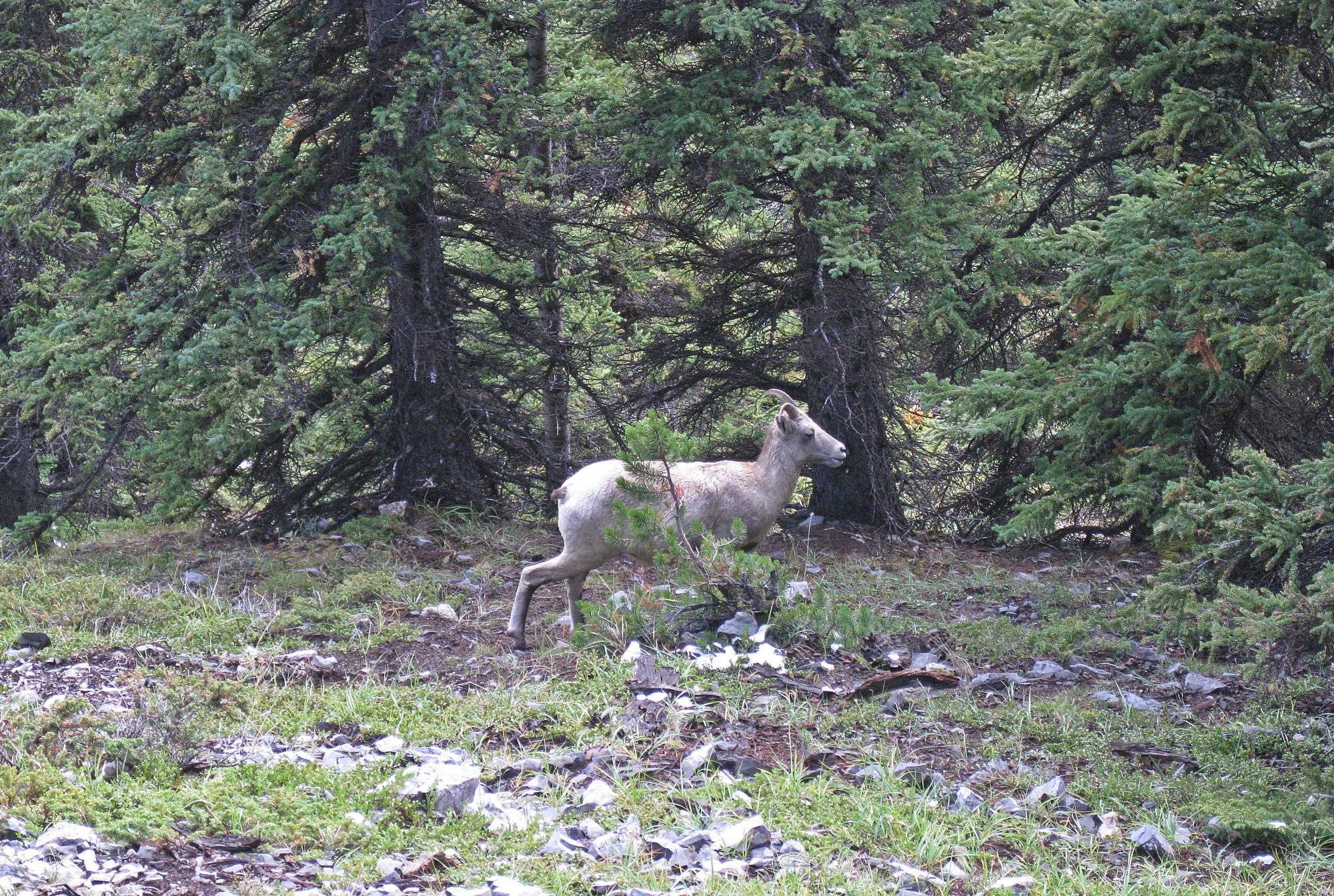
Such stark magnificence. What an amazing place! Loved the rocky mountain sheep – that’s a new species for me.
LikeLiked by 1 person
Thanks Kerry, Come here, you’ll see the sheep all over in the mountains! Maggie
LikeLiked by 1 person
You will need to turn the heat up first…🥶
LikeLiked by 1 person
Haha, yes but it barely rains here 😊
LikeLiked by 1 person
That’s a plus!!
LikeLike
another amazing place to hike it seems!
LikeLike
Beautiful landscape
LikeLike
I remember doing this years ago. My daughters were 7 years old, and life was super busy. We ascended via Headwall Lakes, and stopped for lunch above the highest lake. We fell asleep against a big rock and woke up about an hour later. What the heck – we got up and summit Fortress anyway.
LikeLike
Summit pics are making me dizzy!
LikeLiked by 1 person
You’ve experienced some truly amazing destinations Maggie, what an amazing hike – beautiful.
LikeLiked by 1 person
Yes and lucky that this one is just a short drive away! 😊 Maggie
LikeLike
Hello, I’m Queen from Italy, best wishes 🌻🌼🌸🌹💐 very beautiful photos 😍😍😍
LikeLike