
Majestic mountains tower over pristine lakes making Argentina’s Lake District a hiker’s paradise. Two popular day hikes are Refugio Frey and Cerro Llao Llao. The first takes you to a lagoon below the rugged summit of Cerro Catedral. The second is much shorter but rewards you with breathtaking lake and mountain views. Both hikes make memorable day trips from Bariloche and are ones to keep in mind for your next trip to northern Patagonia.
Refugio Frey Hike on Cerro Catedral
Distance 10.5 km (6½ mi); Elevation Gain – 819 m (2,687 ft), Max Elevation – 1,750 m (5,740 ft)
There are three different trails to reach Refugio Frey, we’ll take you on the Traditional Route. For a relatively easy day hike, it offers some of the most stunning scenes possible, which is why it is one of the most popular hikes in Bariloche.
Access – The trailhead is near Cerro Catedral Alta Patagonia Ski Resort, the largest in South America. If you’re thinking of visiting in the winter, the resort has 35 lifts and an average annual snowfall of 6 m (19 1/2 ft), the season runs from June to October.


Located in Parque Nahuel Huapi, the first 6 km (3¾ mi) are on mostly flat ground, slowly gaining 240 m (790 ft) as it wraps around the base of Cerro Cathedral. In this first section, you are treated to panoramic views of Lake Gutiérrez and Cerro Challhauco over one shoulder. At the same time, Cerro Catedral’s jagged ridge slowly reveals itself above your other side.


If you’re there at the beginning of summer, the mountain slopes in between these views may be decorated with colourful Golden Amancay and Field Carnations, both native to Patagonia.


Once you round the mountain, you are treated to a glimpse of the rocky pillars, called needles, that Cerro Catedral is famous for. But it’s only a sneak peek because that view soon disappears when you cross a bent-tree forest to reach a rest area called Piedritas.


The final 4 km of the hike is where most of the elevation is gained. As you scale up a narrow gully, the mountain’s many needle-like spires and rugged ridge come into view.


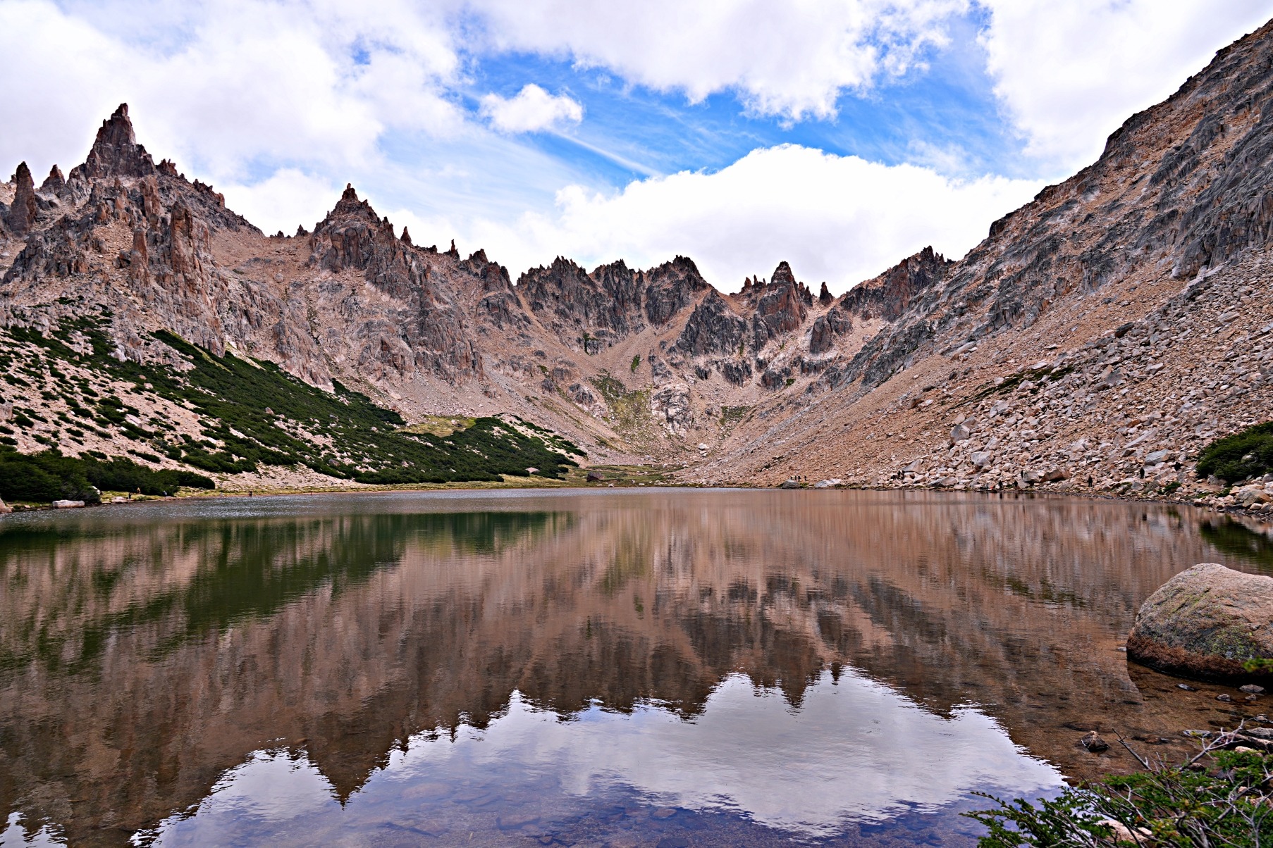
And then you can see Refugio Emilio Frey, straddling a rocky outcrop. It has a classic setting, almost as if it were the dictionary definition of an alpine hut. In addition, its granite construction and wooden gables make it blend seamlessly into the scenery.


If you were happy with the lake views you had on the first section of the hike, you will be overjoyed by the mountain and lake views from the top. Below the hut is the picturesque Toncek Lagoon. We were lucky to visit on a calm day, so the water perfectly reflected the tall peaks above. As other hikers arrived, they were like us, standing in awe at their first sight. This scene makes every step worthwhile and is why it is one of the most popular day hikes in Bariloche.


Seeing the mountain’s jagged needles made us understand why this area is so popular with climbers. As we sat on the lake’s edge, we watched as a few parties inched their way up the nearest tower, named Aguja Frey (Frey Needle) (10.b, 6a+).


With these views and choice of climbs, it is understandable that the area is very busy. In addition to the many day hikers, there are also multi-day backpackers and climbers. The hut appeared to be full, and those who couldn’t get a bed were setting up tents on the stone-riddled ground nearby. It didn’t look like there were any more suitable places for a tent, and yet more campers were arriving by the minute.
Hike Variations
Another option to reach this point is the Frey Por El Filo (Ridge Route). It begins at the top of Diente de Caballo Chairlift in Cerro Cathedral Alto Ski Resort. From there, it is a 10 km (6¼ mi) exposed walk along the ridge that involves quite a lot of scrambling and takes around 3-4 hours. If you plan to do this circuit, you should begin early and ensure you have good weather.
There are also multi-day trips that connect Refugio Frey with Refugios San Martín (Refugio Jakob), Lopez and Laguna Negra. Maybe someday we’ll return to hike to these huts.
Getting to the Refugio Frey Hike
It is very easy to reach the trailhead (and ski resort) by public transit. Bus 55 travels from downtown Bariloche to the resort. You can find the bus stops in the Moovit app or Google Maps. The schedules listed in these apps, though, were incorrect when we were there. To pay for your trip, you can buy and load a SUBE card at marked kiosks in Bariloche. Make sure you load it with enough money for the return trip, because you can not reload it at the ski resort. It is the same card you used in Buenos Aires, Mendoza and San Salvador de Jujuy. It is also possible to pay using a credit card, for only a few cents more.
Tip – Entry to Parque Nahuel Huapi is free, but you must register with the park online before heading on the trail. You can find their information here.
Cerro Llao Llao Circuit Hike
Distance to Cerro Llao Llao Summit – 4 km (2½ mi); Elevation Gain – 215 m (705 ft)
Access – The trailhead for Cerro Llao Llao is not far from the Basque Arrayanes Trailhead parking lot, which is the end of the circuit trail we are going to describe.
Taking over the middle of picture-perfect Llao Llao Peninsula is a municipal park with several trails. Hiking to the summit of Cerro Llao Llao is one. Making it a circuit by combining it with other trails rewards hikers with some of the best views in Patagonia’s Lake District.
The trail begins flat as it walks under Cerro Llao Llao through a dense forest. It’s a good trail but offers no views at first. Don’t despair, those are coming soon enough. After two kilometres, you will reach a branch in the trail and a sign indicating the route to the summit. From here, it quickly climbs up through the trees but opens up in a few places for views of Lake Nahuel Huapi.
Tip – In Argentina, ll is pronounced sh. That means the Llao Llao is pronounced Shao Shao.

From the very top, you are treated to a panoramic vista, allowing you to see the undulating shore of Lake Nahuel Huapi from high above. The trail is quite busy, likely because the reward-to-effort ratio is very high.
If you continue beyond the official summit, a faint trail leads to a lookout where you can see both Nahuel Huapi and Moreno Lakes on the other side of Llao Llao Peninsula.


This route is an out-and-back, so from the summit, return on the same trail until you reach the main trail. From there, you can either return the way you came to make it a short day, or head left and make it a circuit that travels around the park’s shore.
If you take this loop trail, you can make it as long or as short as you want, depending on how many side trips you take. We stopped at several miradors and coves for a total of 15 km (9.3mi) and an elevation gain of 560m (1,830ft). We’ll show you the scenes in order when you travel in a CCW direction from the base of Cerro Llao Llao trail. Not all spots are named, but we titled those in the pictures that have names.
From the Cerro Llao Llao trail, the path leads to an unnamed beach on the north end of the peninsula before taking you to many spots along Llao Llao Bay.


On our walk, we saw several birds and trees that we don’t have in Canada. One that we were delighted to see was the Magellanic Woodpecker (Carpintero Gigante). We watched in amazement as a male and female jackhammered their beaks into the trees in search of food. We’ve seen woodpeckers before, but their large size and the male’s colourful head made seeing them a treat. Their favourite tree is the Coihue. These endemic trees are evergreen, but instead of needles, they have tiny leaves.


If you follow the peninsula’s border from Llao Llao Bay, you’ll reach Villa Tacul, in Mapuche ancestral land. It is free to enter, but there is a fee to park.
The most popular hike is to Mirador Tacul, where you have a lovely view of the lake and the Andes in the distance.
Before leaving Villa Tacul, stop at the large sandy Tacul Beach. Since it is one of the only non-pebble beaches in the area, it is quite popular.


Basque Arrayanes Trail
This short trail can be done at the end or beginning of the circuit around the park. When doing the circuit in a CCW direction, it will be at the end of your hike, and the trailhead is not far from Tacul Beach. The other end is near the Cerro Llao Llao trailhead.
Even though it is named for the endemic arrayan trees, there are more sites to see on the trail than just the forest. First, you can stop at a few points along Moreno Lake.
Basque translates in English to forest, and Arrayan is a type of tree that we’ll show you soon.


From the end of the lake, the trail takes you to the Basque Arrayanes area where dozens of the red-barked arrayan trees are gathered. Although it is small, it is the highlight of this trail. We had seen these trees throughout the park, but they were all lone trees, not a large grouping. These endemic trees, with their gnarled branches reminded us of quenua trees we’ve seen in Peru and Ecuador.


The circuit ends in the Basque Arrayanes Parking Lot. Many people only do sections of the hike, but if you have time, its worth it to walk around the peninsula and see it all.
Puerto Pañuelo
Before getting back on the bus, take a short walk to visit Pañuelo Port (Puerto Pañuelo). It is near the bus stop for the hikes and provides more pretty views of the lake. If you’d rather not hike, you can take a boat cruise from here.


How to get to Llao Llao
If you don’t have a car, it is still very easy to reach the trailheads by public transit. Take #20 bus from Bariloche’s centre. The stop for Cerro Llao Llao and Basque Arrayanes is just before Puerto Pañuelo, where the road turns toward Hotel Llao Llao. If you drive, there are several parking lots throughout the park.
For more information on Bariloche such visit our post Bariloche in Argentina’s Lake District.
We have done other hikes in both Argentina and Chile. You can find all our hikes under Trek-Bike-Ski, or go directly to Argentina’s Cerro Torre, Monte Fitz Roy, Iruya and Aconcagua. And Chile’s Torres del Paine Base and O Circuit.

To read more of our adventures in Argentina, click here.
Coming Next – Cerro Torre Hiking Guide
For pictures from other blogs go to Gallery at monkeystale.ca.
To read about more of our adventures go to Destinations.
If you like what you read, please comment or share (with credit) using the links below.


We'd love to hear from you, please leave a comment.