
Standing on the roof of Africa, we watched the sun slowly show itself above the horizon. Although it’s one of the busiest of the Seven Summits, we found ourselves alone on the summit.
At 5,896 m Mount Kilimanjaro is the highest mountain in Africa and one of the Seven Summits: the highest mountain on each continent. Richard was on his way to being on top of each of these seven and Maggie joined him on this trip. We’re slowly writing about each of his Seven Summit trips. This one is from a few years ago.
Mount Kilimanjaro is an anomaly in the group of Seven Summits as it is not in the middle of a mountain range. Rather it is a volcano rising high out of the surrounding plains. In fact, it is the tallest freestanding volcano in the world. We first saw Kili, as it is called, from the city of Moshi. It’s a small but vibrant town at the base of the volcano. Most trekking groups spend the night in Moshi before their climb. With great views of Kilimanjaro from the streets in Moshi, we were getting excited for our adventure to begin.

Market, Moshi 
Market, Moshi 
Kilimanjaro from Moshi 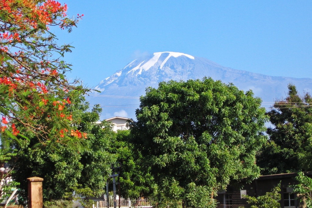
Kilimanjaro from Moshi
There are several routes to reach the summit of Kilimanjaro. We chose to do Umbwe Route because it travels across Arrow Glacier. Gaining elevation quickly, it is considered to be one of the more difficult routes. Normally when hiking at a high elevation, this is not desired, but we were already acclimatized from hiking on Mount Kenya (story coming soon).
Umbwe Gate to Forest Caves
Distance – 11 km; Elevation Gain – 1,450 m
Even before the trek began, we were subjected to what we think is a typical scam. Since we were already acclimatized, we wanted to complete this hike one day shorter than recommended. When registering at Machame Gate, the park ranger said we couldn’t possibly do this route that fast. It was here that, the scam began. We had already bought a package that included guides and porters for the entire route. Park rules at that time did not specify fees per trek only fees per day. They charged us an extra $100 USD each. To make matters worse, we think the money was split between our own guide and the ranger.
After that kerfuffle, we were left wondering what trust we could have in our guide, but we had little choice. We had already paid and wouldn’t be able to find another guide in time. Instead, we tried to put the issue behind us and enjoy our trip.
Our hike began at Umbwe Gate (1,400 m). Thankfully it was much quieter at this entrance compared to the mass of hikers we saw at the Machame Gate. The trail took us through a quiet, dense forest of large trees including redwood and ficus. The trail was steep in parts and offered very few views, but we were gaining elevation so we knew our efforts would pay off.

Umbwe Route, Mount Kilimanjaro
Finally, we reached our first campsite, Forest Caves (2,850 m). The ‘caves’ are more like overhangs in the rockwall, but they provided an interesting atmosphere to our camp. It was incredible that with all of the hikers we saw at the main entrance gate, we were the only ones at this campsite. This route is not very popular because in one day we were already at 2,850 m.
Our guiding company was a no-frills outfit, which is how we hike back home. We sat on the tall roots of a ficus tree for our meal, surrounded by the African wilderness. It was perfect. That is until our head guide began vomiting. When he recovered, he told us he has malaria and needed to go down. We were to continue with the assistant guide. Unfortunately the assistant didn’t know the Umbwe Route so we would instead have to join the busier Machame Route. We were pretty sure it was another scam, but what else could we do?

Forest Caves Camp, Mount Kilimanjaro 
Breakfast at Forest Caves, Mount Kilimanjaro
Forest Caves to Baranco Hut
Distance- 6 km; Elevation Gain – 1,100 m
After a night of discussing our situation, we decided we had to make the best of it and continue. Leaving camp the trail began climbing through the forest, going up a narrow ridge. As we gained elevation, the trees became smaller. Many were covered in Old Man’s Beard lichen which hung from the branches like a white beard. At times the trail was so narrow, we could barely fit between the tight trees. It was a steep trail gaining 1,100 m in only 6 km and the wet forest floor made the climb more difficult.

Old Man’s Beard, Mount Kilimanjaro 
Mountain gladiolus, Mount Kilimanjaro 
Old Man’s Beard, Mount Kilimanjaro
As we got higher, the forest began to thin allowing us to see the incredible landscape. Below us was a deep, forested ravine. Above us Kilimanjaro’s peak was poking through the clouds.

Deep ravine and Mount Kilimanjaro
Eventually the trail emerged from the forest and we entered a very unusual landscape. The open moorlands had an eerie feel. Low clouds were rising between large heather and colourful lobelia. Further on, the bizarre looking giant groundsels with thick trunks and bulbous green tops took over the scene. Mist filled in the spaces between the unusual trees adding to the mystique. This interesting forest continued all the way to our next campsite, Baranco Hut (3,950 m).

Misty moorlands, Mount Kilimanjaro 
Lobelia, Mount Kilimanjaro 
Walking between the giant groundsels, Mount Kilimanjaro 
Giant groundsels, Mount Kilimanjaro
At Baranco Hut, Umbwe and Machame Routes intersect and share the campground. It was a busy place. Large groups set up several tents, both personal ones and larger dining tents. Beside camp the shear Baranco Wall is seemingly protecting the route to the massif above. Most groups stay two nights here for acclimatization and spend the next day scrambling up Baranco Wall. Since we were acclimatized, we only spent one night.

Baranco Hut, Mount Kilimanjaro 
Giant groundsels in front of Barnaco Wall, Mount Kilimanjaro
Even though we suspected our guides had scammed us, it was hard not to like them. They were always joking around and having fun. They served us amazing meals cooked over their kerosene stove. In fact the meals were usually too large. Maggie usually gave half of her large lunch to the assistant guide. He would initially protest saying ‘Eat Momma, Eat’, but eventually gave in and ate the offered food. He spoke very little English so we tried to learn a small amount of Swahili. He taught us simple words such as ‘jumbo’ (hello), ‘mzuri’ (good), ‘asante’ (thank you). Our favourite phrase was one that he often said to us, ‘pollo, pollo’. It means slowly, slowly. We weren’t good at following his instructions though.
Baranco Hut to Barafu Hut
Distance – 9 km; Elevation Gain – 600 m
In the morning we were treated to an incredible sight. A gorgeous alpenglow covered Kilimanjaro in a bright red colour. Throughout our time on the mountain, the mornings were usually clear, but by mid day clouds came in to obstruct the views.

Sunrise on Kilimanjaro from Baranco Hut 
Kilimanjaro and Baranco Wall
The Machame trail begins by crossing a boulder field under Baranaco Wall and then scales 275 m to its top. The steep rocky trail was slippery from the daily mist. From the top of the wall it felt as if we were right beside the giant. Mount Kilimanjaro has three cones. The tallest is called Kibo and we were passing under it as we walked around the mountain. Kibo is the most photographed view of Kilimanjaro. Mawenze and Shibo are the other two, lower cones.

Above Baranco Wall, Mount Kilimanjaro 
Kibo from above Baranco Wall, Mount Kilimanjaro
Above the wall vegetation was scarce and eventually the ground was barren. Only rocks added texture to the earth. As we walked to the top of a small hill, the rugged peak of Mawenze came into view. Its jagged top has a completely different look than the rounded cone of Kibo.
Barafu Hut (4,600 m) is located in a rocky area with very few flat areas. Luckily our tent was in a great, flat spot under Kibo’s towering peak. We hoped to be on its summit the next morning.

Barren land below Barafu Hut, Mount Kilimanjaro 
Mawenzi Peak, Mount Kilimanjaro 
Mawenzi Peak, Mount Kilimanjaro 
Barafu Camp below Kibo Peak, Mount Kilimanjaro
Barafu to Kilimanjaro’s summit to Mweka Gate
To summit: Distance – 5 km; Elevation Gain – 1,296 m
To Mweka Gate: Distance – 26 km; Elevation Loss – 4,096 m
We were awakened early on summit day. We began trekking an hour later than other groups, but still we left too early. Getting to the summit from Barafu Hut is not an easy walk. The trail begins almost immediately, climbing a series of steep switchbacks on loose stones and scree. With headlights on we slowly made our way up the steep moraine. We could see rows of headlamps above us from all the climbers who left earlier. Everyone plans to be at a lookout on the crater rim called Stella Point (5,700 m) in time to watch the sunrise.
Step by step we made our way up the mountain. Each step was more and more difficult as there was less and less oxygen to fill our lungs. Many of the others on the trail don’t hike regularly so it was no surprise that within a couple of hours we were ahead of everyone.
We arrived at Stella Point far too early. It was pitch black and very cold. We had a brief rest at Stella Point and decided to continue. We’d hoped to see the sunrise from the summit.
From Stella Point the trail is easier as it traverses clockwise around the crater’s rim. It was dark, so we couldn’t see the crater but we knew each step took us closer to our goal. Finally, we arrived on the roof of Africa. Uhuru Peak on Kibo is the highest point on Kilimanjaro at 5,896 m. The sun was just starting to poke above the earth to begin a new day. It was a spectacular sunrise. After seeing so many people on the trail for the last two days, it was nice to have the summit to ourselves.

Sunrise from Kilimanjaro summit 
Sunrise from Kilimanjaro summit
It was very cold on the summit. We were dressed as we would during winter in Canada, but our guide only had a light sweater. We lent him a jacket, which later we gave to him. Even with that he was very cold, verging on hypothermia. Richard wanted to stay on the summit to take more pictures. Our guide said he wasn’t allowed to let him remain alone so instead, we hiked down. Of course, we later we regretted leaving so early.

Kilimanjaro Summit 
Kilimanjaro Summit
The trail down, followed the same path that we took up. This time we could see what we missed. Beside us, Kilimanjaro’s shrinking glaciers glowed in the morning sun. Further on, dozens of hikers were only now making their way up from Stella Point.

Glaciers at sunrise, Mount Kilimanjaro 
Glaciers on Kilimanjaro 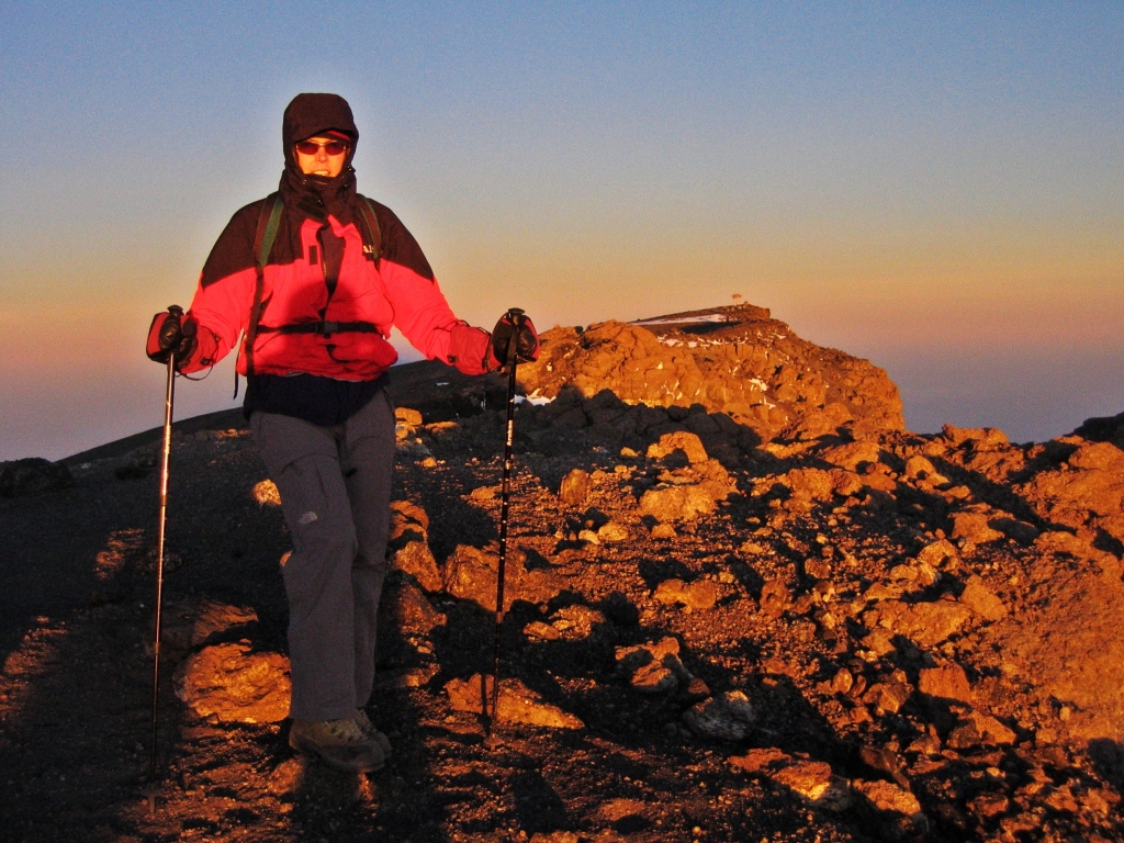
Near Stella Point with the summit in the background, Mount Kilimanjaro
A little further down Mount Meru came into view. It is another high volcano that is often used for acclimatization before climbing Kilimanjaro.
The steepest part of the trail is between Barafu Hut and Stella Point. It was almost more difficult on the descent with the loose stones acting like ball bearings under our feet. Our hiking poles came in very handy. Finally, we arrived at our tent, where our chef made a sumptuous congratulatory breakfast.

Mount Meru from Kilimanjaro 
Above Barafu Hut, Mount Kilimanjaro 
Route above Barafu Hut, Mount Kilimanjaro 
Above Barafu Camp, Mount Kilimanjaro
It was still very early in the day, so after eating breakfast we were back on the trail. We took the common descent route, Mweka, all the way to the bottom. This busier route allowed us to see how hard the porters work. Porters were carrying tables, chairs and even medical stretchers up the trail. By mid-afternoon we were at the base of the mountain, exhausted and happy at another of the Seven Summits completed by Richard and the first for Maggie.
When to trek
Kilimanjaro can be climbed at any time of year. The driest months are January, February and September. During November and March/April it is more likely to be wet, but is still climbable.
Which Route to take?
There are several routes to get to Kilimanjaro’s summit. Research the routes and chose one that meets your needs in terms of experience, length of days on the mountain and remoteness. Some routes take more days but traverse more difficult terrain. Others have easy trails, but are very short so it’s difficult to properly acclimatize. Some are busy with a lot of other trekkers, other routes are less busy but are more remote.
Acclimatization
Acclimatizing is very important for success on a high mountain like Kilimanjaro. The only way to acclimate is by a slowly gaining elevation over a number of days. Active rest days are usually spent climbing to a higher elevation and returning to camp. The town of Moshi is where most guiding companies spend the first night before the hike. It’s only at 900 m elevation so it isn’t high enough to help acclimatize. This means you need to become acclimatized while hiking on the mountain. Some people acclimatize by hiking nearby Mount Meru (4,562 m). We had already climbed on Mount Kenya the week before and were well acclimatized so could chose a quicker route on Kili.
Coming Next: Wildlife Spotting in Serengeti and a Visit to Stone Town in Zanzibar
For extra pictures from Tanzania click here. For pictures from other blogs go to Gallery at monkeystale.ca
To read about more of our adventures go to Destinations
.
If you like what you read, please comment or share (with credit) using the links below.

Another great post!!! It is annoying that you couldn’t take the Umbwe route as I have heard that it is quite special. Glad that you had a wonderful time. I did a few days on the Marangu route and sometimes wish I’d paid the extra to complete but I enjoyed it nonetheless.
LikeLiked by 2 people
We were really disappointed at the time, especially because it put us on a busy route. But we still had a great trip and went through very interesting terrain. Thanks for reading!!
LikeLiked by 2 people
Yes, it looks it. Glad you made it all the way 🙂
LikeLiked by 2 people
Such an epic trek! I had no idea it was so busy.
LikeLiked by 2 people
We knew it would be busy, but it was far busier than we thought. I guess it’s on a lot of bucket lists!
LikeLiked by 1 person
This sounds like such an incredible experience. It’s a bit unsettling to hear about all the scams, but sounds like you still managed to have a good time. And this just adds to the adventure. The sunrise from the summit looks magical.
LikeLiked by 1 person
Ya, the scams make a good story in the long run, and no one was hurt. It was a great sunrise, from so high above the plains, it was really special. Thanks for reading!
LikeLiked by 1 person
Great post and fantastic photos. It’s unfortunate you had to pay extra and might have gotten conned, but going up Kilimanjaro was worth all that. I’m surprised your guide didn’t wear enough clothing – I guess he wasn’t too experienced.
LikeLiked by 1 person
Thank you, it’s all part of climbing in Africa I guess. We think the guide wasn’t used to be the lead guide. He knew the route to the summit, but sure wasn’t prepared. Or maybe that was another scam to get a warm jacket- who knows.
LikeLiked by 1 person
Wow, if that was indeed a scam to get a jacket, he really sounds like a greedy rascal. Hopefully it wasn’t and he really was just unprepared.
LikeLiked by 1 person
Awesome adventure to be sure. Glad it all worked out for you. Thanks for sharing. Allan
LikeLiked by 1 person
Thanks Allan, It was a great adventure. Thanks for reading!
LikeLiked by 1 person
Amazing story ..I felt like I was there with you..so interesting hearing about the guides as well
LikeLiked by 1 person
Thank you Alison, It was a challenge, just not the way we thought it would be! Thanks for reading! Maggie
LikeLike
Great post. I have a question. How many days up? Down?
LikeLiked by 1 person
We were pretty quick. Three nights, four days. We summited on the fourth day and walked all the way down the same day. We could do it because we spent a few days high on Mount Kenya already.
LikeLiked by 1 person
Amazing climb. Loved reading every bit of it. The pictures are fantastic. Hope I get to go there some day. Sorry to hear that you were taken for a ride in certain places but good to know you had fun anyway.
LikeLiked by 1 person
Thank you, glad you enjoyed the story. I hope you get to see it too, it’s a fascinating part of Africa. Maggie
LikeLiked by 1 person
Great post!!!!! Amazing pictures!!!!
LikeLiked by 1 person
Thanks Stephanie!!
LikeLiked by 1 person
Thank you for sharing! Sounds like you had an amazing time!
LikeLiked by 1 person
Yes it was a great adventure! Thanks for reading!!
LikeLiked by 1 person
You’re welcome!
LikeLiked by 1 person
Fabulous photos! What an adventure. Congratulations on your climb.
LikeLiked by 1 person
Thank you Rebecca! It was a great climb!
LikeLiked by 1 person
Appreciated reading about another one of your awesome adventures!
LikeLiked by 1 person
Thank you! Glad you enjoyed it! Maggie
LikeLike
Amazing all the hikes and climbs you guys have done. I know that the scams can be frustrating but at least the guides were fun. I guess it’s just part of life there, where they struggle constantly to make ends meet. Nice of you to hand over the jacket at the end. Those groundsels are really cool…never seen anything like them. Another enjoyable read. Thanks!
LikeLiked by 1 person
The vegetation was really interesting. We saw similar trees at the same elevation on Mt Kenya too. Very bizarre looking. Yes, the scams are so annoying, but overall, no harm done. I think we gave them a smaller tip than we would have otherwise, so it’s probably all the same.
LikeLiked by 1 person
Climbing the world’s tallest freestanding mountain has to be an amazing experience! Is it mandatory to climb it with a licensed guide or is there a way to go solo? The mountain doesn’t really requires technical skills and anyone with a moderate level of fitness, positive attitude, and a body that adapts relatively well to altitude have a good chance of success. I love reading about your mountain adventures, but you already know that. Looking forward to more. Thanks for sharing, Maggie and have a good day 😀 Aiva
LikeLiked by 1 person
Thanks Aiva, Oh, I should have mentioned about guides. Maybe I’ll add it. Yes you are required to hire a guide and porter/cooks etc. I think it’s more of a make work initiative than anything. It is not a technical mountain at all, which is probably why it’s so popular. The key is taking it slow to acclimatize and you’re right, having a body that does acclimatize well. Thanks again for reading and your comments, Maggie
LikeLiked by 1 person
Fabulous recount and amazing pictures, especially of the sunrises.
LikeLiked by 1 person
Thank you, nothing like a sunset from the top of the world! 🙂
LikeLike
Amazing photos. I had the chance to hike the Marangu route but only to base camp. Thank you for sharing your view from above!
LikeLiked by 1 person
Thank you, glad you could enjoy our pictures then from higher up the mountain.
LikeLiked by 1 person
Beautiful photos! I’m used to Lobelia that is the tiny deep purple flowers, almost a ground cover. The ones you saw in Africa were quite different. What an adventure!
LikeLiked by 1 person
Thank you, I just looked up lobelia and the ones in Africa at elevation are part of the same species as the small purple flowers. It’s crazy how different they are. I never thought of it before.
LikeLiked by 1 person
Amazing huh?!
LikeLiked by 1 person
Did you organize the trip from back home or while you were over there? What outfit did you use and do they supply gear as an add on option? Thanks for all these posts, very motivating!
LikeLiked by 2 people
We did this trip a few years ago so I can’t remember the name if the company, but I’m not sure I’d recommend them anyway. We found them in the Lonely Planet Trekking East Africa book which I think they stopped printing. We did arrange everything from home because at the time we only had a 3 week vacation. The guiding companies usually provide tents, sleeping mats and even sleeping bags if you want. Park rules say you have to hire a guide, cook and porters. They have their own stove, dishes etc. They usually provide all meals and drinking water. You don’t need specialized gear for Kili. Are you thinking of going? There are a couple of new routes that are supposed to be less busy so you should look at those.
LikeLiked by 1 person
Another fantastic hiking experience. Too bad about the scams, though. They really have you between a rock and a hard place.
LikeLiked by 1 person
Ya it was frustrating but at least no harm was done. It’s to be expected I guess. There were so many touts and scammers in the towns that we should have expected it. I laughed at your rock and hard place comment about a mountain climb:)
LikeLiked by 1 person
Fantastic photos and amazing adventure!
LikeLiked by 1 person
Thank you Leif! It is an interesting place to hike!
LikeLiked by 1 person
I add my praise to all the previous ones. Every time I read your stories, I feel like I am with you on the hike. I really appreciate the attention to detail like the flowers or plants and not just the vast landscape. Thanks for the hike.
LikeLiked by 1 person
Thank you! Glad it’s not just us that appreciates the different vegetation. I think it helps to show how different each place is.
LikeLiked by 2 people
i must admit i didnt realise that it was that high. Nearly 6000 metres – higher than I’ve ever been in my life to be honest! Amazing story, amazing how the scenery changes and is so varied over the whole trip. fascinating post thanks so much for sharing
LikeLiked by 1 person
Thanks Andy, I think it’s the fourth highest of the Seven Summits. It’s interesting to see the landscape change the higher we climb. And being near the equator, Kilimanjaro has really interesting vegetation. Maggie
LikeLiked by 1 person
This is a great read on Kilimanjaro, one of the most famous of the Seven Summits. I thoroughly enjoyed your description of the things you saw as well as your breathtaking photos. For sure, the landscape itself looks magnificent, but I’m particularly intrigued by those giant groundsels. They look so otherworldly! I’m wondering how similar or different the views would have been if you ended up completing the hike through Umbwe Route.
LikeLiked by 1 person
Thanks Bama, I know I wish we could have seen Umbwe. We still would have gone through the groundsel forest, but have more glacier views I think. We saw the groundsels on Mt Kenya too, but never anywhere else. They are very strange looking and with the mist, it was otherworldly. Thanks for reading! Maggie
LikeLiked by 1 person
What an adventure, so glad it worked out for you. You really do some adventurous hiking. Amazing photo’s again
LikeLiked by 1 person
Thank you! We love to spend as much time in the mountains as we can, and some days have more adventure than others 🙂
LikeLike
Such an amazing adventure and spectacular sunrise photos! I’d be happy just to see Kilimanjaro one day! Looking forward to reading about your safari. My son and daughter in law climbed Kili a couple of years ago in September and they have photos at the top in what can only be described as a blizzard!
LikeLiked by 1 person
Oh no! It is definitely cold up there!! Trying to figure out the safaris as we went to 4 parks but don’t want to overwhelm people with animals pics.
LikeLiked by 1 person
Amazing! I wish I could climb one of the mountains you write about. 🙂 I’m not sure which is my favourite picture because all of them look stunning.
LikeLiked by 1 person
We were impressed with the views on Kilimanjaro. It had so much more to offer than we expected.
LikeLiked by 1 person
Brings back memories of our time there…didn’t hike but saw it in the distance..
LikeLiked by 1 person
It’s an interesting mountain because you can see it standing on its own from a long way off.
LikeLike
Spectacular post! One day I’d like to try this climb…on the easiest route.
LikeLike
Yes you should. It’s not difficult, just plan to take as many days to do it as possible.
LikeLike