
The magical landscapes of Gros Morne National Park were carved by glaciers millions of years ago. In their wake glaciers left tall fjord-like cliffs, flat-topped mountains, deep freshwater lakes and a rugged coastline. The scenery is stunning.


We had driven across Canada on Our Great Canadian Roadtrip and were excited to explore the most eastern province of Newfoundland.


We hadn’t even officially entered Gros Morne National Park when we enjoyed our first of many stunning vistas. The long undulating shore of Bonne Bay’s East Arm makes a breathtaking scene. We stopped several times as we drove around this inlet, amazed by the perfect landscape.


As we drove further along the shore of East Arm the rounded top of the park’s namesake, Gros Morne Mountain, came into view. At 806 m it’s the second highest mountain in Newfoundland. They may not be tall mountains, but they are beautiful.
Gros Morne translates in English to ‘large lone mountain’. On the western side of Newfoundland there are a lot of French names. With names like Port aux Basques, Port au Port, L’Anse aux Meadows and Gros Morne it’s easy to see the strong French influence in the area. In 1763 when the 7 Years’ War ended between France and Britain, the fishing rights to western Newfoundland were given to the French. As a result there was a large influx of fishermen from Brittany, Normandy and Basque who established French settlements in this region.

There are more than 100 km of hiking trails in Gros Morne National Park. Most are short walks to ocean viewpoints, but others are long, steep climbs to the mountain tops. The most well known is a hike to the top of Gros Morne Mountain. Since we were more interested in coastal views, we didn’t do this hike.
Picturesque Lobster Cove Head protects the entrance to Bonne Bay. There are several easy walking trails that allow you to explore the coastline. The trails extend for a kilometer on either side of the pretty Lobster Cove Head Lighthouse and offer lovely views across the bay.


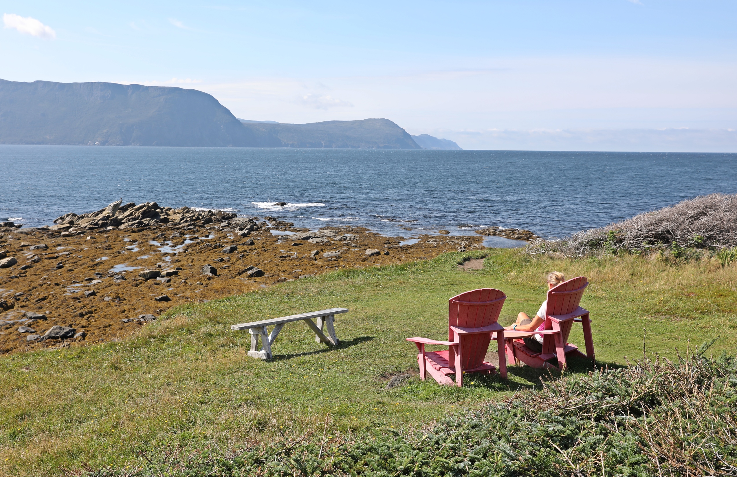
The main town in Gros Morne National Park is Rocky Harbour which has a picturesque setting on the edge of Bonne Bay. The backdrop for the view of town is Lookout Hills on the other side of Bonne Bay.

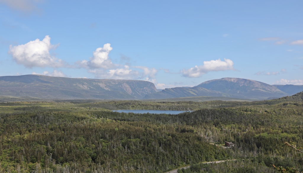
The mountains in the park are unlike mountains we would see in Western Canada. Many have flat tops that drop off suddenly into shear walls. Glaciers formed these interesting landscapes a millennia ago. In fact, Gros Morne National Park was designated a UNESCO World Heritage Site because of its glacial and geologic history.
The most famous pictures of these flat-topped mountains are from Western Brook Pond. Tall fjord-like mountains drop into a large, calm freshwater pond. An easy 2 km flat trail takes you to the edge of the pond where you have a closer look at these shear cliffs. Layers of mountain walls seem to overlap like a zipper making it appear that there is barely enough room for a pond to fill in between them.


A popular boat cruise will take you on the narrow lake between the giants. The boat can drop you off at a hiking trail that takes you to a lookout point for the iconic view of the park. Unfortunately a guide is required for this hike and there is a $250 per person fee for the boat ride and guide. That price was a little too steep for us to pay for a hike and we were satisfied with our view from the lake shore.
Berry Hill was one of the most scenic hikes we took that had views away from the ocean. From the top of the small hill was a pretty view of Berry Pond below with Gros Morne Mountain in the distance.
Green Point is a small grassy cape with sharp cliffs leading to a pebble beach. Between the beach and the flat top, the sides were covered in dense bush. We tried to cut a path through them, but it wasn’t possible. Along the shore a few colourful fishing shacks were the icing on the cake of this postcard perfect spot.
In addition to beautiful scenery it’s also an important geological spot. Fossils are imbedded in the cliffs at the tip of Green Point. Specific fossils found here allowed geologists to determine the boundary between the Cambrian and Ordovician periods. This area was designated as a global stratotype and it now serves as a benchmark to correlate ages of sedimentary rock around the world.


Tips for Visiting Newfoundland
- The TransCanada Highway in Newfoundland is shaped like a horseshoe as it travels along the west, north and eastern edge of the island province. There are smaller highways leading to the various capes, but in order to get from east to west, you have to drive all around the northern edge. There are no shortcuts across the island. It will take a full day to drive from one side to the other.
- Watch for moose while driving, especially between dusk and dawn. With 125,000 moose on the island there are, on average 700 moose-car collisions per year. That explains the funny signs we saw along the highways.

- If you’re planning to rent a car or RV, the best advice is to book early. Even when there isn’t a worldwide pandemic, there are not be many available.
- Newfoundland Standard Time is 30 minutes ahead of Atlantic Standard Time so do don’t forget to change your watch.
- Don’t confuse St. John’s, Newfoundland’s capital city with St. John in New Brunswick.
Where to stay in Gros Morne National Park
Camping – There are 5 campsite in Gros Morne National Park. We absolutely loved our site at Green Point. In addition there are a few private campgrounds in and near the park.

Hotel, Bed & Breakfast – There are quite a few options for hotels and Bed & Breakfasts both in and near the national park including the communities of Rocky Harbour, Trout River and Norris Point.
Getting to Newfoundland
Marine Atlantic ferries travel between Sydney, NS and western Newfoundland’s Port aux Basques (7 hrs) twice a day and to the eastern province’s Argentia a few times a week. If traveling to or from Argentia it is a long 16 hour trip, usually overnight. The best way would be to arrive at one port and leave from the other so you can tour the province. During Covid however, the ferries were booked weeks in advance and we weren’t able to coordinate schedules so ended up driving back to Port aux Basques. Another ferry travels between Blanc Sablon, Quebec and St. Barbe on the Great Northern Peninsula. It’s a much shorter ferry ride, but the drive to reach Blanc Sablon is quite long.
Most flights travel to St. John’s, but there are also international airports in Stephenville and Gander. Gander is famous for accepting planes from the US during 9/11.
Read more about Newfoundland – Vikings in Newfoundland, Western Newfoundland, Bonavista Peninsula, Trinity, Conception Bay, St. John’s, Signal Hill, Day Trips from St. John’s
For more pictures from our travels around the world visit Gallery on monkeystale.ca
To read stories from other parts from Canada click here, or other countries visit Destinations.
If you like what you read please share, with credit, using one of the links below.

Such a beautiful part of our country. Always meant to get there, but have not yet. Thanks for the visit. Allan
LikeLiked by 1 person
We were in awe of the views, and we had already been to some incredible places on this trip. Next time Allan… Thanks for reading 🙂 Maggie
LikeLiked by 2 people
What a beautiful park and breathtaking photos!
LikeLiked by 1 person
Thanks, the views are stunning and so unlike the other Atlantic Provinces. Thanks for reading 🙂 Maggie
LikeLiked by 1 person
Stunning is indeed the word for it. Beautiful!
LikeLiked by 2 people
Thanks Ken, it is a very beautiful part of Newfoundland. Thanks for reading 🙂 Maggie
LikeLiked by 1 person
Another beautiful place – your photos are just lovely 🙂
LikeLiked by 1 person
Thanks Hannah, it is a gorgeous part of Newfoundland. Thanks for you comments 🙂 Maggie
LikeLike
Such breathtaking scenery plus scientific importance make this area a must see.
LikeLiked by 1 person
It is a must-see. There are so many fascinating spots in this small part of the province. Thanks for reading:) Maggie
LikeLike
So so pretty! I’m loving these Newfoundland posts… and also using them to make updates and additions to the itinerary I have put together for our future Newfoundland vacation.
LikeLiked by 1 person
You will love Newfoundland, there are so many different and stunning places. Maggie
LikeLiked by 1 person
Another beautiful area. One of countless beautiful areas in Canada.
LikeLiked by 1 person
That’s true, we are lucky to have so many beautiful places to see in the large country. Thanks for your comments 🙂 Maggie
LikeLiked by 1 person
What a stunning journey! Thanks for sharing your wonderful info and photos!
LikeLiked by 1 person
Thank you, It is a gorgeous island province 🙂 Maggie
LikeLiked by 1 person
Stunning photos, the landscape is as ever amazing! Not sure we’ll ever make it to Canada, but your articles always show it would certainly be a worthwhile trip.
LikeLiked by 1 person
There are so many amazing places in this country to see. The problem with visiting is that it is so large, but it is definitely worth a visit. Maggie
LikeLiked by 1 person
That campsite looks amazing! What a nice view to wake up to!
LikeLiked by 1 person
It was one of the nicest campsites we’ve ever had. Such an incredible spot! Maggie
LikeLiked by 1 person
We were there in 2011 but I’ve no photos at all so really enjoyed this….
LikeLiked by 1 person
Oh no! I remember reading that you lost pictures. Glad I could help you relive the trip 🙂 Maggie
LikeLike
🥰😍
LikeLike
Great photos. Moose crossing! Beware, your car will suffer…! (hopefully that’s all)
LikeLiked by 1 person
Thanks, yes the moose crossing signs were much more dramatic than we’d seen anywhere else. Thankfully we didn’t see any running across the roads. Maggie
LikeLiked by 1 person
Yes, Maggie. I think they best convey the message; Don’t mess with moose (meese as we like to call them) or they’ll mess with you!
LikeLike
🤣🤣
LikeLiked by 1 person
As usual WOW WOW WOW
LikeLike
Wonderful details and insight as always. Lovely photos. I hear that lobster is king in those parts.
LikeLiked by 1 person
Thanks Suzette, lobster and cod I think, but it wasn’t lobster season when we were there. We saw quite a few traps piled up on land.
LikeLiked by 1 person
Oh I see. Very good. Thank you. I do enjoy your journals. It is the time in the world where your travel stories have even deeper meaning. I thank you so much. Cheers.
LikeLike
Gros Morne does indeed offer attractive landscapes and hikes, you walk on the seabed brought to the surface. I had also done some research on the French Shore Treaty in force from 1713 to 1904. It gave the French exclusive fishing rights, but on condition that they did not settle on land. Conversely the English could settle but could not fish. This explains why the coast remained sparsely populated for a long time.
LikeLiked by 1 person
I had read that they weren’t supposed to settle on the land but many built homes and because it was so far away no one checked or were bothered by it. Kind of a crazy treaty that doesn’t really help either side.
LikeLiked by 1 person
It’s not very surprising from the French, they don’t follow the law 🙂
LikeLiked by 1 person
😊😆
LikeLike
Although these mountains are not that tall, they look imposing, I guess thanks to those overlapping layers of mountain walls. What a beautiful place! This must be one of the most impressive and awe-inspiring landscapes in the western part of Canada.
LikeLiked by 1 person
Eastern Canada, but yes Gros Morne is one of the top spots in Atlantic Canada. The mountains are so different from what we’re used to but no less impressive. Gros Morne won’t disappoint. Thanks for your input Bama, Maggie
LikeLiked by 1 person
Oops, I mean Eastern Canada!
LikeLiked by 1 person
😊
LikeLiked by 1 person
Lovely views of the rugged shoreline. This brings back such fond memories of when we visited Newfoundland and Gros Morne a few years ago. We didn’t do the boat cruise at Western Brook Pond either. The views from the shoreline were good enough for us too.
LikeLiked by 1 person
Initially I was so disappointed because I wanted to have that iconic view of Gros Morne above Western Brook Pond. Then I got a little angry at Parks Canada because you have to take a guide and only 1 company offers this service. Anyway in the end we were happy with the view from shore😊 Maggie
LikeLiked by 1 person
Beautiful pictures, Maggie! Just loved it!
LikeLiked by 1 person
Thanks Jyothi! Maggie
LikeLiked by 1 person
What beautiful coastal views! Like you I would prefer those hikes to the ones inland. You seem to have had lovely weather here too 🙂
LikeLiked by 1 person
We were lucky that the weather was good for the days we needed but it poured in between! The views in Gros Morne are absolutely breathtaking. Thanks for your inout Sarah, Maggie
LikeLiked by 1 person
Lovely images…another place I would love to visit but we haven`’t been yet. You truly did visit the entire country…(Suzanne)
LikeLiked by 1 person
We did travel almost coast to coast and Newfoundland was one of our favourites. Definitely put it on your must-see list. Thanks for reading! Maggie
LikeLike
Ah, Gros Morne!
I used to work for a company with an office in St. John’s and I did a lot of work with the Newfoundlanders in our company. I was meant to visit our office and they’d set up a trek there. It was meant to be in June 2020… Then Covid happened, the shutters came down, the company decided to use the pandemic as an excuse to squeeze some cost out the business and I was made redunant, so that never happened. But thanks for the “Zoom visit”, Maggie!
LikeLiked by 2 people
Oh no, too bad! It’s an awesome and unique part of Canada. We absolutely love Newfoundland. I hope you get to go one day, but in the meantime we’ll take you on a tour 😊 Maggie
LikeLiked by 1 person
Thanks Maggie!
LikeLike
The scenery certainly is stunning and spectacularly raw, Maggie and the park is such a big place, you have to have a plan in place to make the most of the never-ending series of wonders and delights 🙂 Thanks for sharing and have a good day 🙂 Aiva
LikeLiked by 1 person
Yes it is big and we didn’t have enough time to see everything so had to pick and chose our spots. It’s ruggedly gorgeous. Thanks Aiva, have a great weekend!
LikeLiked by 1 person
Those flattop mountains are really interesting to see. Also love that picture of the fox – so nice of it to stand still for you. 😉
LikeLiked by 1 person
I think he wanted food and left when he realized we wouldn’t feed him 🙂 The flat topped mountains we so beautiful and so different from what we usually see. Have fun with your kitties 🙂 Maggie
LikeLiked by 1 person
This sounds like my kind of national park! Glacially formed areas are my favourite!
LikeLiked by 1 person
You would love it! And I was thinking of you. I just read that Newfoundland will be the best place to see the eclipse in 2024. You could see both in one trip 🙂
LikeLiked by 1 person
Oh that’s amazing! Thanks for that info!
LikeLike
What a excellent destination. Gros Morne is. I’ll be back
LikeLiked by 2 people
We love Gros Morne. It has such a unique beauty. Thanks for reading Kelly.
LikeLike
Lots to love there
LikeLike
Beautiful landscape, sculpted by water and glaciers. Breathtaking.
LikeLiked by 2 people
Yes, it really is a gorgeous park. Thanks Ruth! Maggie
LikeLiked by 1 person
You had such an incredible road trip. I am always amazed at how scenic each place is, and so different from the last stop.
LikeLiked by 1 person
We were amazed how different each place was too! We thought the views can’t get any better, and then they do! Thanks for reading Chelsea, Maggie
LikeLiked by 1 person
Stunning!
LikeLiked by 1 person
Thank you!
LikeLiked by 1 person
Gros Morne looks even more beautiful than I imagined. What a cross country trek you’ve done! That is so cool. Are you going north next?
LikeLike
Beautiful pictures! Wonderful information!!
LikeLiked by 1 person
Thank you! Maggie
LikeLiked by 1 person
so many beautiful spots – thanks for sharing!
LikeLiked by 1 person
Thanks Andy
LikeLike
Simply stunning. Great writing folks!
LikeLiked by 1 person
Thank you!
LikeLike
I’ve heard of Gros Morne but somehow had no idea it was in Newfoundland! Looks stunning. I will definitely have to explore eastern Canada at some point. 😀
LikeLiked by 1 person
I guess they’re not great marketers 🙂 Canada’s east coast has more scenic views than we had expected. It’s definitely worth a trip. Thanks for reading! Maggie
LikeLiked by 1 person
Another place now on our list. a wonderful post
LikeLike