
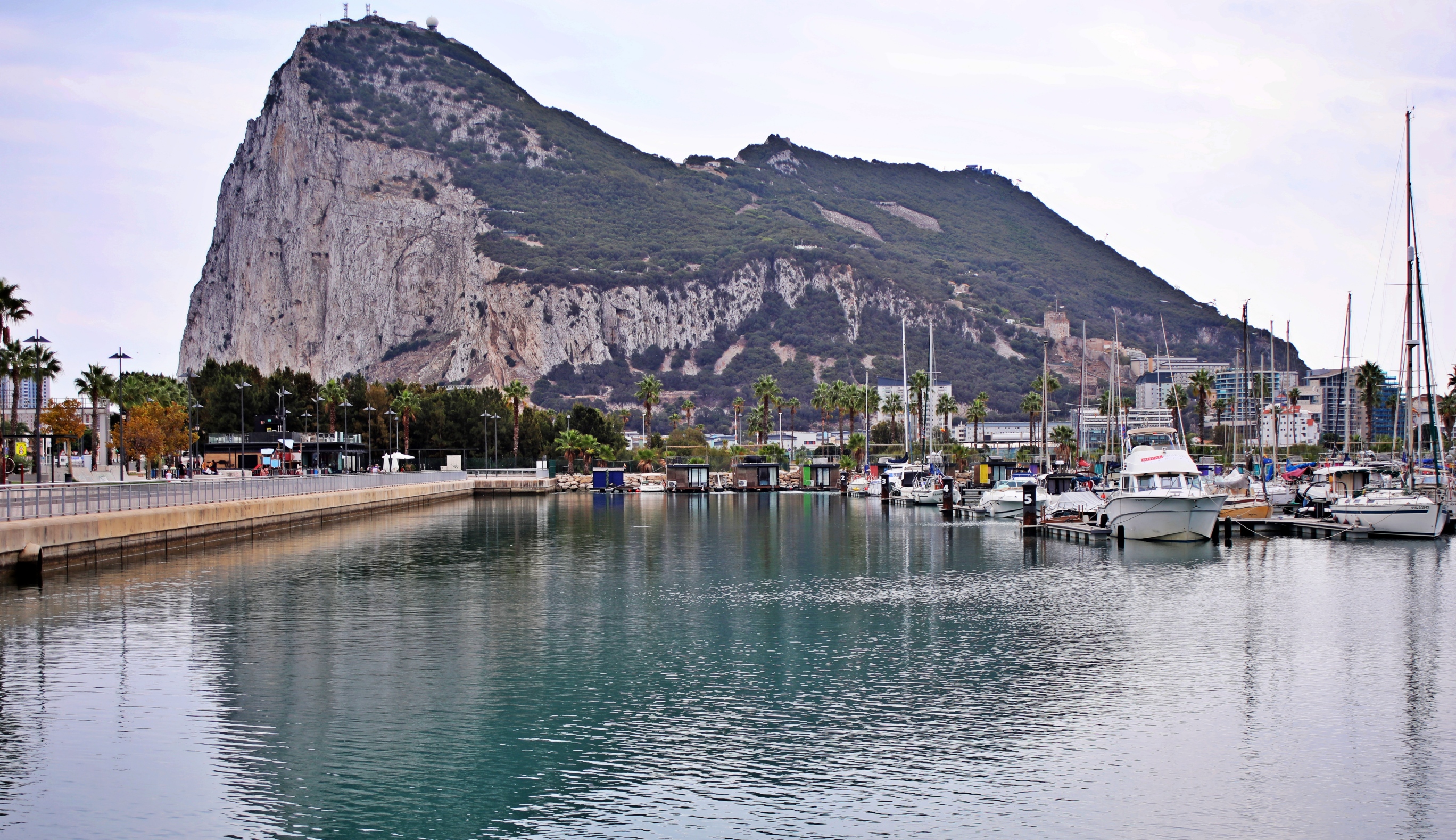
Our first glimpse of the Rock of Gibraltar was on our drive above the Spanish port city of Algeciras. The view of the distinctive rocky peninsula jutting into the water made us very excited to visit this famous site. Gibraltar has a lot to see, much more than we expected. It is very easy to explore the sites on your own without joining a tour, so we created a visitor’s guide to help you plan your visit to Gibraltar.

The British Commonwealth territory is on the edge of the Strait of Gibraltar and is located only 7.7 nautical miles (14.24 km /8.9 miles) from Morocco. This combination made Gibraltar coveted land for centuries. It looks like an island but is actually a peninsula. A narrow strip of flat land connects the massive limestone rock to Spain. Finally seeing it in person was a little overwhelming.
The map below is of Andalucía, Spain, but we included Gibraltar so it is easier to appreciate its location. You can find it just above the most southerly point of Andalucía.

Hercules Legend
Have you heard the legend about how this famous rock was formed? Gibraltar is said to be one of the Pillars of Hercules. As part of his penance for killing his wife and child, Hercules had to complete Twelve Labours for King Eurystheus. When he was completing his tenth, Hercules needed to cross over Atlas Mountain. Instead of climbing up and over though, he smashed through the mountain and thus created the Strait of Gibraltar. This left two pillars on either side of the strait. The Rock of Gibraltar was created on the European side. There is an ongoing debate as to which peak was formed in Africa. Some believe the legend points to Mount Hacho in Ceuta, others say Jebel Moussa in Morocco.
Either way, it is a great legend to accompany this unique natural feature. We saw another site related to the Hercules’ Twelve Labours near Tangier, Morocco. (Coming Soon)

Now a little history
Gibraltar’s history goes as far back as the Neanderthals, over 100,000 years ago. Much later, the Greeks were fascinated by the peak as you can see in their Hercules legend.
Over the millennia, it was the cause of many battles. In the 700s, the Moors landed on The Rock and then repeatedly fought against the Spanish for ownership. After the Spanish controlled it for a few centuries, they lost the treasured land to the British in the 1700s. More battles ensued between the Spanish and the British, but it has remained under the British Commonwealth since the 1700s. For the British, it was a key stopping point on voyages to and from India. During the Second World War, they used it to keep track of naval traffic between the Atlantic and Mediterranean.

Today, Gibraltar is a self-governed British Overseas Territory and falls under the UK’s defence and foreign policies. We were told by a local man that the residents are British, but he was sure to point out that they are very definitely not English.
Guide to visiting Gibraltar
Gibraltar lies on the edge of the Spanish city, La Línea de la Concepción. The big rock has a majestic look in its position behind the city’s marina. Since Brexit, to enter the British Territory, you first have to go through both Spanish and British customs offices, so don’t forget to bring your passport. They’re located on the other side of the marina.

Gibraltar City
After going through border control, whether biking or walking, you must cross the airport runway. It was quite a strange experience to walk across the tarmac. The benefit though, is this flat, open land allows amazing views of this huge rock. After the runway, you have to go through two tunnels, left-over from its days as a military post.


After the tunnels, you’ll emerge onto Grand Casemates Square and what feels like Jolly Old UK. It was once the location of 19th century bomb-proof barracks but today, is a busy square with over-priced cafes and restaurant patios.
From Casement Square, take a stroll through downtown. As you walk along the streets, it will be very apparent that you’ve left Spain. There are recognizable shops like Marks & Spencer; red telephone and mail boxes; restaurants serving fish and chips, bangers and mash; and of course, pubs serving English beer. All of the locals speak with a British accent, but most of the staff are Spanish.


Gibraltar Nature Reserve
After spending time in town, buying your favourite duty-free British snacks, it’s time to explore the best part of this territory, Gibraltar Nature Reserve. This large park takes over most of the top of the Rock and combines war time history with scenic views.
You have a few options to reach it. If you want to walk, you can take one of the walking trails at either end of the city or the very steep Mediterranean Steps, located on the other side of the island. If you don’t want to walk you can take the cable car or join a tour. We opted to walk and began by climbing the steps toward the Moorish Castle on the north end of the Rock. We had seen the castle’s Tower of Homage from town so knew that would be a good place to start.


Moorish Castle
We hadn’t climbed very far before we saw Almond Tower that was once part of the Moorish Castle. The odd name was derived from its shape. It’s difficult to see in the picture below, but its outer wall is curved, like an almond.

A little higher is the entrance to Gibraltar Nature Reserve. If using Google Maps it is called Ticket Office of Moorish Castle. Entry to the park is not cheap, but it includes entry to all of the museums.
Immediately beside the entrance is the historic Tower of Homage (also called White Tower) and Queen Charlotte’s Battery. Both are a part of the Moorish Castle. There aren’t many remnants left from the Moors’ time on Gibraltar, but this castle is one of them.
One of the main things that the Moors gave to Gibraltar is its name. In the 700s, Muslim leader Tarik ibn Ziyad and his troops left Tangier, Morocco destined to conquer parts of the Iberian Peninsula. They landed at the base of the rock. It is said that upon landing he declared the rock to be Jabal Ṭāriq (Tariq’s mountain). That name eventually transformed into Gibraltar. The tower was built hundreds of years later, but was named in honour of Tariq.


Hay’s Tunnels
After visiting the tower, walk a little higher to find Hay’s Tunnels. These tunnels were excavated during WWII and included army storage, a hospital, barracks and workspaces. They were part of a long series of interconnected WWII tunnels that were carved through the mountain wall. The residual rock and debris were used to build the new surface of the runway.
The army also built a variety of casements and ledges used for canons, riflemen and watchmen. There are a few exhibits so you can see how the soldiers lived and worked. We walked the length of the tunnel and emerged at a lookout above the airport. During the war, gunners used this spot to keep watch over the Strait.
Hay’s Tunnels are still under restoration, so they are quite dusty and you must wear a helmet.


There are a few different museums with reenactments of the many battles that took place on Gibraltar. Old Willis’ Magazine has a display of the first British military structures that were built during the Great Siege of Gibraltar (1779-1783). There’s not a lot to see, but if you’re walking by, it’s worth a stop.

Great Siege Tunnels
Higher up the mountain are the more well-known, Great Siege Tunnels. These are similar to Hay’s Tunnels, but have been completely refinished. As we entered through the main door, we heard The Liberty Bell March playing on the speakers. All we could think was how odd to hear Monty Python’s Flying Circus theme song in a historic British war tunnel. Stranger still, when we learned it was actually an American marching song.
The original tunnels were built during the Great Siege. This battle took place during the late 1700s when the British were defending it against Spanish and French armies. The tunnels were significantly extended during WWII when another 34 miles of tunnels were drilled through Gibraltar Rock. Progress was apparently very slow, so they called in the specialists. The 1st and 2nd Tunnelling Companies of Royal Canadian Engineers, some 300 strong, were deployed to Gibraltar. Their expertise allowed them to complete the tunnels quickly.

Not all of the tunnels are open today to visitors, but you can walk through quite a few to reach the far side of the Rock. Along the way, there are many displays of canons and equipment used in the tunnels. As well you can see many sentry posts, barracks and casements.
In one of the casements, there is a display of soldiers and a canon. We had seen strange holes in the wall as we walked across the airport earlier. Here, we finally learnt their purpose.


Cable Car Top Station Lookout
Arriving at the Top Station of the Gibraltar Cable Car puts you in the busiest part of the park. We had barely seen anyone until we reached this point. All of a sudden, it was teeming with tourists. Not only did many arrive on the cable car, but tour vans also drove up to this point. There were so many, that they created a traffic jam on the one-way road. This made us very glad we didn’t take a tour.


If you go to a lookout above the cable car you can see the other side of the Rock and a few beaches far below. When the weather is clear, you can see Africa on the other side of the strait. It was very hazy when we visited, so our view wasn’t very good. For us, it was more impressive to see the steep walls that allow you to appreciate how the Pillars of Hercules legend evolved.


Barbary Macaques
The official Apes’ Den is further down the mountain, but we were excited to see dozens of Barbary Macaques outside the cable car station. There are hefty fines if you are caught feeding them, but some people must, which is why they are here. They don’t have a tail so they are often called apes, but they are in fact, monkeys.
They were very docile with two exceptions. One stole sunglasses from the head of a guide and another grabbed someone’s shopping bag. The monkey was very disappointed when all he found inside was toilet paper. This was a good warning that even though they’re not aggressive, you need to take care of your belongings.


Skywalk
Not far away from the cable car station is the glass-bottomed Skywalk. The best part of visiting the skywalk is the unobstructed view toward the Spanish city of Algeciras on the other side of the Bay of Gibraltar. It was very busy when we were there, and that meant more monkeys.


Douglas Way
From the cable car station you can take the Douglas Way trail that follows the ridgeline. From the trail, you can enjoy more wonderful views of this picturesque mountain. Although it’s fairly busy, there weren’t nearly as many people walking on the trail as there were around the cable car.
The trail leads to O’Hara Battery and a small museum showcasing WWII engine rooms, armament, etc. This spot is also a great vantage point to see the sheer walls of Gibraltar. Because it is at the end of the rock, we thought there would be a view of Africa. Unfortunately, the view is obstructed by an old war-time Gun Pit.

By arriving here, you have explored the top of the park from end to end. On the way back down to town, there are a few more sites to see, and likely a few more monkeys.

St Michael’s Cave
St Michael’s Cave was a big surprise. This massive cave is jam-packed with stunning stalactites, stalagmites and columns in all sorts of shapes and figures. A light show shines coloured lights on these gorgeous natural features. We would have preferred to see it in more natural light though.
There is an epilepsy warning at the entrance stating that the show could trigger a seizure.


Windsor Suspension Bridge
A little further down the mountain is Windsor Suspension Bridge. It’s a new bridge that spans a small gully and offers a view of the Bay of Gibraltar.

Apes Den
The official Apes’ Den is not far from the suspension bridge. There were only a few monkeys here when we visited. Most were found higher up the mountain, where there are more tourists.
A legend says if the apes disappear from The Rock, the British must leave Gibraltar. This is apparently why Winston Churchill ordered replacement monkeys from North Africa! There is debate on how they originally got to this European spot.

Devil’s Gap Footpath
This footpath can take you all the way down the mountain to town. The upper section is quite rough, but it eventually ends in a good staircase. At the bottom it is called the Union Jack Steps. You could begin here and do the above route in reverse if you prefer.

Where to stay when visiting Gibraltar
There are hotels and guesthouses in the city of Gibraltar, but they are quite pricey. Another option is to stay in the Spanish city of La Línea de la Concepción, which is located on the border with Gibraltar. A little further away is the busy port city of Algeciras where there is a large selection of hotels.
Note – Gibraltar uses the British pound. Most shops accept Euros, but at a high exchange rate. Credit cards are widely accepted.
How to get to Gibraltar
There is very little parking on Gibraltar, so it is better to not drive. If you stay in La Línea de la Concepción, you may be able to walk or take a taxi to the border. If you stay further away, you may be able to take a bus to La Linea. Bus 120 travels from Algeciras to the main bus station in La Linea which is only a couple of block from the border. Don’t forget to bring your Passport.

This article is now featured on GPSmyCity. To download this article for offline reading or create a self-guided walking tour to visit the attractions highlighted in this article, go to Walking Tours and Articles in Gibraltar.
Coming Next – Spain’s Costa del Sol – Estepona, Marbella & Casarás
For pictures from other blogs go to Gallery at monkeystale.ca
To read about more of our adventures go to Destinations.
If you like what you read, please comment or share (with credit) using the links below.


We'd love to hear from you, please leave a comment.