
The trek takes you through small mountain villages, past crops of corn and amaranth and up to one of the most beautiful views in the Indian Himalayas from Kuari Pass.
When to trek – The best time to trek is before or after monsoon season which is June (there may still be snow on the pass) and Sept to the end of Oct.
What to bring – In addition to the usual hiking and camping equipment be sure to bring: Rain gear including pack covers, warm clothing, warm sleeping bag (-5°C), sunscreen
Do I need a guide? – For almost all multi-day treks in Uttarakhand you require a guide. We used Incredible Adventures in Rishikesh. They look after permits, transportation, mules and food. Their equipment is in good condition.
Getting to Chefna – the drive from Rishikesh to Chefna is 7 hours on a winding mountain road. We joined the group a day late, so we drove right to the first campsite at Ghuni (8hrs).The first day of the trek begins outside of Chefna and is a short 2 hours to Ghuni.
Getting to Rishikesh from Tapovan – It’s a long 8 hours back to Rishikesh on a similar mountain road until they join again at Ghat. Note, this is not the same Tapovan as on the Source of the Ganges Trek.
Do I need a permit? – In October 2018 the Uttarakhand government was making changes to their overnight camping policies. There was a lot of confusion by all of the trekking agencies as to where they could camp. As a result, the best way to trek to Kuari Pass is how we’ve detailed below. Some groups did the trek in the reverse direction but only up to Kuari Pass and then down in the same day. This would make for a long day with close to 1300m elevation gain and loss in one day.
Note:
- We did this trek in the mid October. It rained one day, late in the afternoon. The sun was hot when it was out, but evenings were chilly (near 5°C)
- Trekking times listed below do not include breaks
For the full story and more pictures click here.
Day1 Chefna (2000m) to Ghuni(2550m) 2 hrs, Ascend 550m


We joined the group one day late so didn’t do this first stage. It’s a 2-hour trek through farm land.
Day 2 Ghuni (2550m) to Jhinjhi (2310m) 4hr 15 min, Ascend 740m, Descend 980m


The trek climbs the hill immediately behind Ghuni, passed spindly karshu trees and then through forests of rhododendron, pine and oak. At times the trail would emerge out of the forest to pass through small meadows where shepherds bring their flocks of sheep and goats to graze for the summer. The trail continues to climb to the first small pass, Ramni Pass (3064m), where we had great views of the snowy peaks in the distance. After the pass we walked through a forest of massive walnut trees to reach the small village of Jhinjhi. We camped in a field beside a farm house.
Day 3 Jhinjhi (2310) to Pana (3000m), 4hr 14 min, Ascend 6500m, Descend 250m


The trek drops down approximately 250m from Jhinjhi to cross the river on an old bridge. It then ascends up on the other side to the same level. It follows the deep contours of the valley through a forest of rhododendrons and pine to reach the small village of Pana on the other side of the valley. Not long before Pana we came across a large troupe of the beautiful, gentle Grey Langur Monkeys. We camped on a plateau high above the village with amazing views of Nanda Ghunti (6309) and Ranti (6063.
Day 4 Rest day in Pana
The trek usually goes toDhakauni today and the next day over Kuari Pass today and camps on the other side. The following day is a trek to a look out on Pangarchuli Peak. With the changes to camping permits, the camp below Pangarchuli Peak is closed. We think to make up for this lost day we had a rest day in Pana. Our assistant guide is from Pana so he took us to his home where his mom made us lunch. It was a nice day, but we didn’t need a rest.
Day 5 Pana (3000m) to Dhakauni (3690m), 3hr 58min, Ascend 300m, Descend 450, Ascend 650m


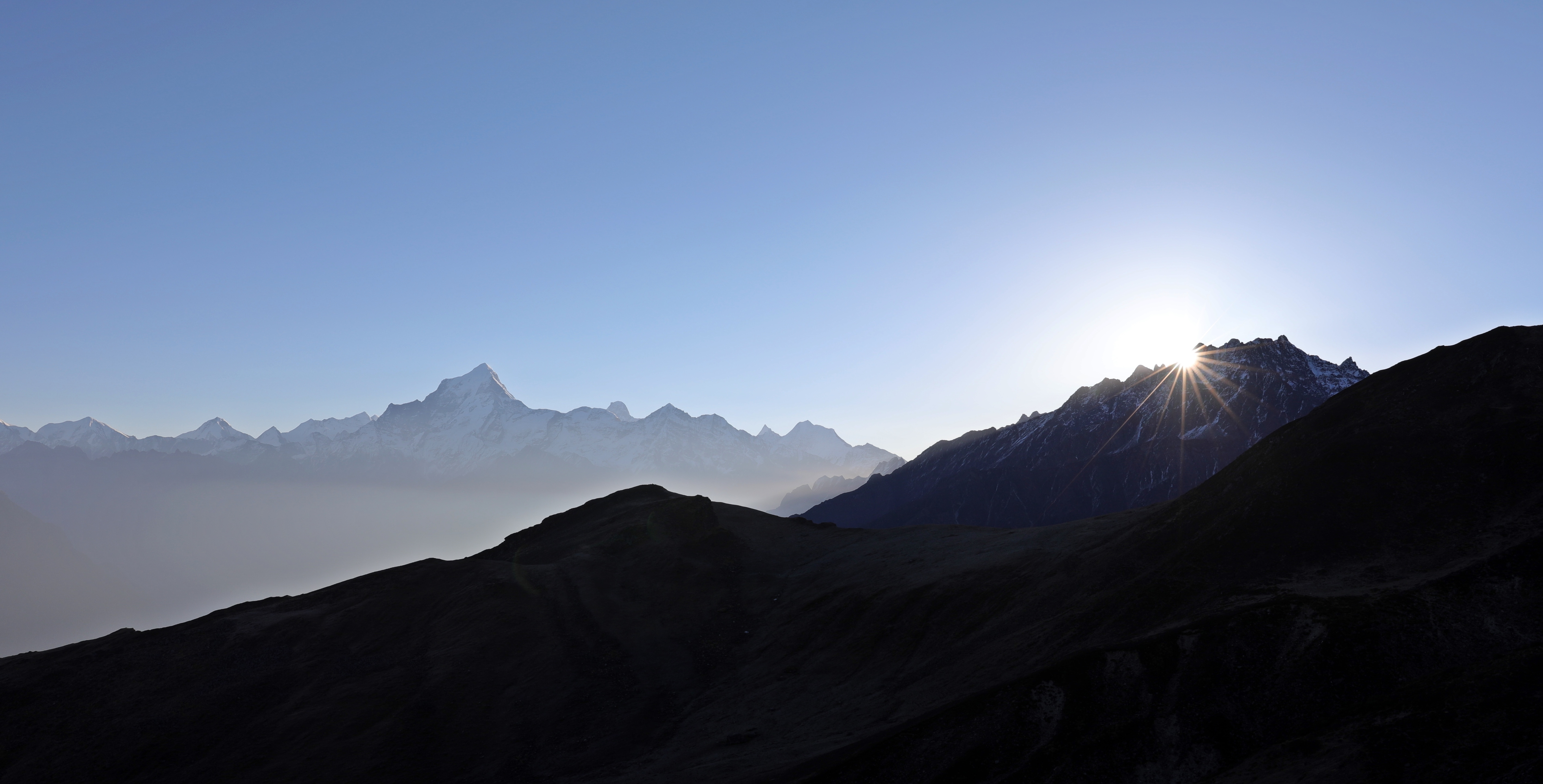
The trail climbs through the rhododendron forest to a small col where you can see Kuari Pass. It then goes through a wild, uninhabited forest following the contours of the valley. The valley below is steep with deep rocky cliffs jutting up from the river. The trail is surrounded by high rocky walls with many waterfalls. After passing a few streams the trail climbs steeply up the side of the mountain to get above treeline. Camp is 250m below a ridge that is the start to Kuari Pass. We made a run up to the ridge for the sunset and were glad we did as we had amazing views. (info below)
Day 6 Dhakauni (3690m) to Tapovan (2500m) via Kuari Pass (3800m) 1 hr 15min to ridge, 30 min to look out, 3 hrs to Tapovan


We left our campsite at 5am so that we could see the sunrise from the pass. As soon as we reached the top of this ridge we were astounded by the amazing 180° view. We could see the high snow-covered Himalayas including the alpenglow on Hathi Ghoda ( 22,070ft), Neelkanth (7141m) Dunagiri (7067m) and Changabang (6864m) and to the east, the tip of Nanda Devi (7816). We continued to a small knoll above the pass to see the sunrise and a better view of Nanda Devi.
The trek down is a moderate grade over grass for a while, but the last 30 – 45 minutes is a very steep trail on loose rock and ball bearing sand. You have amazing views of Nanda Devi for most of the way down, including from your end point of Tapovan.
For more of our treks click here, or go directly to Hampta Pass (Himachal Pradesh), Great Lakes Trek (Kashmir), Markha Valley Trek (Ladakh), Hidden Valley Trek (Ladakh), Phuktal Trek (Zanskar), Everest 3 Passes Trek (Nepal), Manaslu Circuit (Nepal), Upper Mustang Trek (Nepal), Jumolhari Yaksa Trek (Bhutan), Kalaw to Inle Trek (Myanmar), Pinnacles Trek (Borneo), Carstenz Pyramid (Indonesia).
For pictures from Richard’s Everest summit click here: https://www.youtube.com/watch?v=VFmsecd6yN0


