

The Hunza Valley’s remote location in the northernmost region of Pakistan, means it has some of the country’s most beautiful landscapes that range from tall peaks with rugged glaciers to fertile valleys. Once an important trading link between Central Asia and the Indian subcontinent, it has a history that is quite different from the rest of Pakistan. It is a fascinating part of the country and one we had been looking forward to seeing.
Driving through the Hunza Valley along the Karakoram Highway is considered one of the most scenic drives in the world. To get there however, we first had to drive along the Indus River from the city of Skardu. In this area the roaring river has cut a deep canyon out of the steep, mountain walls. The arid scenery was very similar to our drive from Skardu to Askole to trek to K2 Base Camp. Thankfully the Skardu-Hunza Highway is in much better condition than the road to Askole.

At times when driving by these uninhabitable-looking mountains we’d pass a sign indicating a turnoff to a village. We’d look up at these tall, crumbling mountains and thought the sign must be wrong. A village couldn’t be here. But sure enough, high above the highway were terraces filled in with green gardens and a group of flat roofed homes.


In one area we saw dozens of mines in the mountain cliffs. They were mining for precious stones. The only access to these mines was by scaling up the steep walls. What a tough job those miners have. As if mining isn’t a dangerous enough occupation, they also have to rock climb to reach the mine’s entrance.

Once we reached Gilgit River, our driver turned onto the scenic Karakorum Highway toward the city of Gilgit. This marks the entry into Hunza Valley. About 45 minutes outside Gilgit, we passed the spot where the Indian and Eurasian continental plates collide. Our guide didn’t tell us until after we had passed so we didn’t stop to see the small sign. The collision of these plates makes Gilgit-Baltistan the 5th most earthquake prone area in the world. It is said to be the point where the Karakorum and Hindu Kush Ranges meet the rest of the Himalayas.
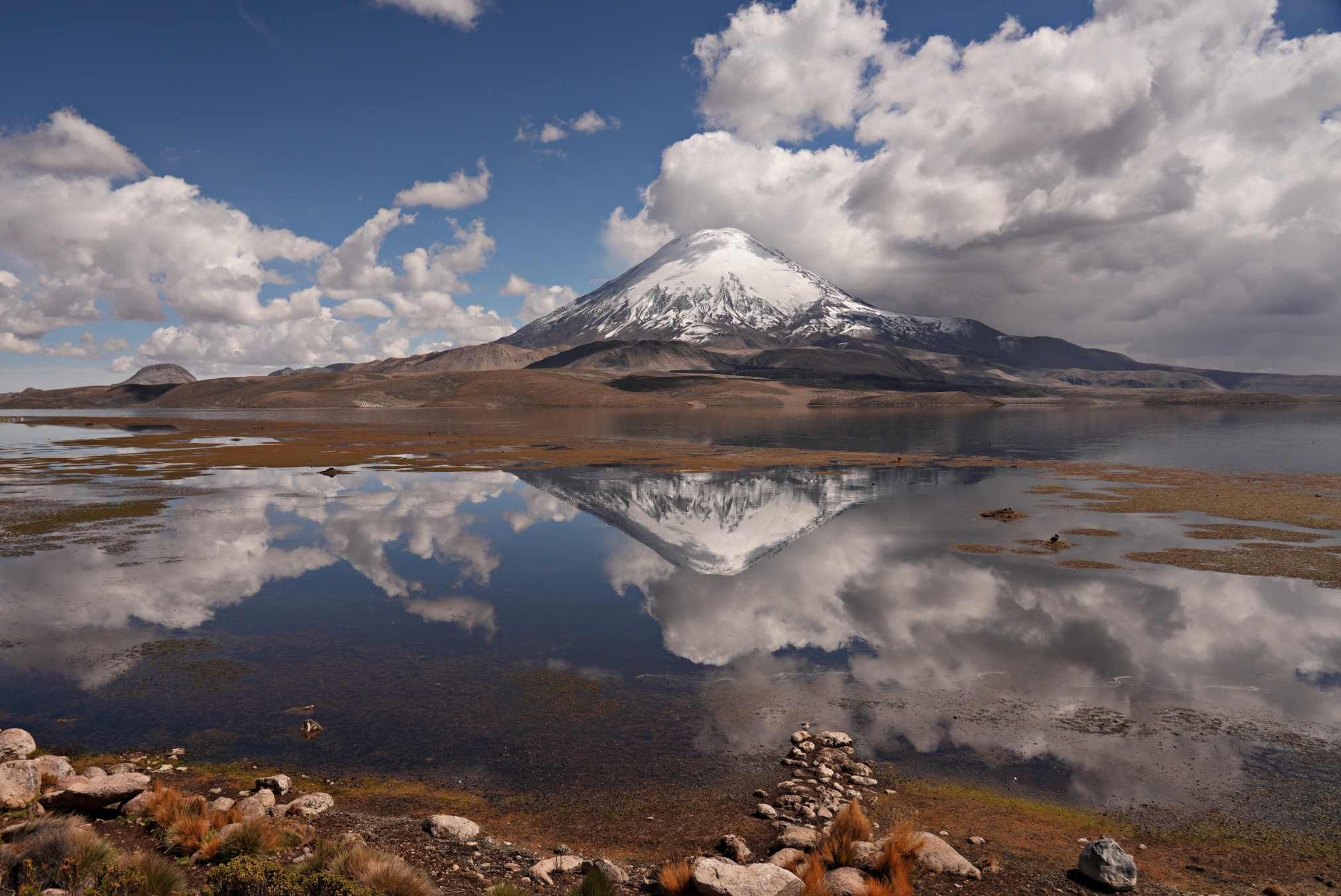
The further we drove up the highway, the more the scenery changed. The mountains were becoming larger and more of them were capped in snow. In the distance, a huge white behemoth took over the skyline. The snow covered Rakaposhi (7,788 m/ 25,551 ft) towers high above anything else around. It is the highest mountain in the region and is very picturesque.
As we were soon to discover, it is a popular site for local Pakistanis. The town of Ghulmat is located at the base of Rakaposhi and offers a great view of the mountain. This viewpoint however, is a bit of a circus. People were crowded in the numerous restaurants and hotels at the mountain’s base. There were even ziplines and lines for tightrope biking. We didn’t join these adventure seekers though. Instead we enjoyed the mountain scenery from below.


Like many regions in the world, Hunza Valley has a complicated political history. For hundreds of years it was an independent monarchy governed by the reigning Mir of Hunza. In the late 1800s it came under the British protectorate and became a princely state. When the British partitioned India in 1947, Hunza joined Pakistan, but was able to maintain its autonomy as a princely state. This land division is still being disputed by India, China and Pakistan. In the 1970s Pakistani President Zulfikar Ali Bhutto dissolved the monarchy and put Hunza under the administration of the Northern Areas with other regions such as Gilgit, Baltistan, Jammu and Kashmir. Most recently, the Northern Areas was subdivided and Hunza was placed in the newly formed Gilgit-Baltistan in 2009. This region was granted limited autonomous status and special permits are required to visit.
Hunza Valley is further divided into Upper, Central and Lower Hunza. Each area has its own language and culture, but most of the people in all three regions follow the sect of Islam called Ismaili.
Karimabad
The city of Karimabad is considered to be the birthplace of the Hunza Kingdom. Surrounded by tall, snow-capped peaks of the Karakorum mountains, this area was an important stop on trade routes to Central Asia. It was originally called Baltit and is the site of not just one, but two Medieval fortresses.
Strategically placed on a shelf 300 m above the Hunza River is the 1,100 year old Altit Fortress. The Mir of Hunza built this castle, thus establishing the capital of his kingdom. Its elevated location as well as a tall tower allowed the Mir to keep a lookout for approaching enemies.


The fortress is not only remarkable in its dramatic setting, but also in its design. Wood was integrated into the fortress walls to add flexibility when earthquakes hit. Being located very close to the point of collision of the continental plates, earthquakes are very common.

Inside the fortress you immediately enter into the reception room. It has a convenient wine cellar built below its floor. In the middle of the room is a large pillar which we assumed was a supportive structure until we were told it is a standing tomb. Apparently, a man was buried alive in it after he tried to start a rebellion against the royal family.

Beyond the reception room there are conference rooms where the heads of local tribes would meet to discuss concerns in the kingdom. As well there are bedrooms, kitchens, meeting rooms and a lot of spaces for storage. It does not have a lot of comforts and life would have been difficult, even for the king.
Carved into some of the wooden boxes and pillars are Hindu swastikas and Buddhist symbols. These are reminders that the people of Hunza were Buddhist for many generations before they converted to Islam. The people in Hunza today follow Ismailism, a liberal sect of Islam. Their leader is Aga Khan. Religion is so important in this region that the city of Baltit was renamed Karimabad in honour of the current head of the Ismaili community, Prince Karim Aga Khan. This is the same branch of Islam that is followed in the Pamirs in Tajikistan.


From the fortress balconies you can look out upon the roofs of modern day Karimabad. The balcony was also the location of the toilet, so everything would go straight over the cliffs. Hopefully there weren’t homes located there in the 10th century.
We could also see the other fortress, Baltit, on top of another rocky point across town.


Baltit Fortress was built 800 years ago when the Mir of Hunza married a Tibetan Princess. The design of this fortress does resemble fortresses and temples in Tibet. You can see the similarities in our post 7 Days in Tibet.
In front of the fortress a friendly guard, wearing a traditional hat and great sideburns, was happy to pose for a picture.


Inside the fortress there are similar rooms to the ones we saw in Altit with receptions, watchtowers, kitchens and even a prison. In this fortress, the royal family had summer and winter bedrooms. The main difference was that summer rooms had sunrooms while winter rooms had fireplaces.
As rustic as this castle seems, it was the main residence for the royal family until 1945.


Below Baltit Fortress, the steep streets have many shops selling local crafts as well as nuts and dried fruit.


The clouds were low and threatened rain when we toured the city. Early the next morning though, we had a beautiful view of a cloud covered Rakaposhi from our mountain top hotel in Karimabad. We also had a bird’s eye view of Baltit Fortress where its position on the knife edge ridge was more apparent.


On the outskirts of Karimabad is one of only a few Buddhist remnants in Hunza. Sacred Rocks of Hunza have ancient inscriptions carved in the Kharosthi language. It includes names of Buddhist pilgrims and merchants from its days as a trade route.

From Karimabad we continued to following the Hunza River and entered into Upper Hunza. The population in this area are mostly Wakhi. They migrated to the area from Persia and are related to the Wakhan people in Tajikistan and Afghanistan. In fact, Hunza’s northern edge borders Afghanistan’s Wakhan Corridor.
Attabad Lake
Earthquakes are vey common in this region and we saw many areas where old and recent rockslides tore down the mountain. One area in particular gives a stark reminder of how dangerous it is to live in this region. In 2010 the village of Attabad was swept into the river by a landslide bringing with it over 200 homes. As many 20 people were killed. The landslide created dams in the river that resulted in the formation of a lake named after the village. Today only a few homes still remain in the green trees above the new lake. It was difficult to fully appreciate the beauty of this newly formed lake knowing how many lives were lost in its formation.

The flooding that followed the landslide caused damage to many other villages in the valley as well as to the Karakorum Highway. To prevent further catastrophes, a new tunnel was built with the help of the Chinese Government. The Pak-China Friendship Tunnel is 5 km long and takes you to the other side of the 21 km long Attabad Lake. We emerged from the tunnel into a small resort area with boat rentals and lakeside cabins. It seemed rather strange to celebrate this lake where so many people lost their lives.

Passu Cones
As we continued along the Karakorum Highway, it began to rain and we could barely see any of the surrounding mountains. When we finally reach our hotel, we quickly dashed into our rooms, trying to stay dry in the downpour. After a couple of hours, the rain stopped and the low clouds rose to reveal one of our favourite views in all of the Hunza Valley. Our modest hotel was enveloped in an amphitheater composed of the gorgeous Passu Cones. We stared in awe at the tall, rocky cone-shaped mountains whose pointed tops were majestically reaching for the sky. It is a spectacular mountain scene.


Wanting to get a better look, we walked toward these impressive mountains and the views kept getting better and better. Even behind us, the mountain scenery was breathtaking.


The Karakoram Highway continues to travel to the Pakistan-China border. It is this section that makes it the highest international road in the world. It climbs to a maximum elevation of 4,714 m (15,466 ft) at Khunjerab Pass. But as seemed to be our luck in Pakistan, weather and road conditions prevented us from going further. Instead of going to the mountain pass, we turned around, retracing our steps out of Hunza. On our way out of the region we stopped to see Passu Glacier that we were unable to see the day before in the pouring rain.


Hopar Glacier
Instead of going through Karimabad again, we took a side trip and followed the Nagar River. The road climbed and climbed up the mountainside for over 400 m to reach Hopar Glacier. On the way we passed villagers who were picking apricots from the trees. Our driver stopped so we could buy a bag of the delicious ripe fruit.

Near the top a large, green plateau at 2,800 m gave incredible views of the snow-capped Karakoram Range. Growing in those fields we found an interesting crop for this Muslim nation. Almost every field was fringed by marijuana plants!


To reach the 18 km long Hopar Glacier we had to descend a couple hundred meters on a hiking trail. As the 2nd fastest moving glacier in the world, Hopar Glacier is a jumbled mess of seracs and crevasses. The 90 m (300 ft) thick glacier quickly makes its way down the valley by a much as 30 cm (1 ft) a day. Because of this movement it is covered in rock and gravel that it has churned up from the mountains on its side. This makes it blacker than many other glaciers. At its head is the stoic Kapel Mountain that holds its own in the spectacular scene.

Nanga Parbat
As we made our way out of the Gilgit-Baltistan region we followed the Hunza and then Gilgit Rivers downstream. An hour after passing the city of Gilgit we were treated to an amazing mountain view. Layers of brown mountain ridges formed a frame for Nanga Parbat (8,126 m/26,660 ft), the 9th highest mountain in the world. Snow covers most of its ridge and it is well known in mountaineering circles for its harsh terrain. It hadn’t been successfully climbed in the winter until 2016.
After seeing Nanga Parbat we had now seen all but one of the world’s 8,000ers. Tibet’s Shishapangma was shrouded in cloud on the one day we had hoped to see her a few years earlier.

The semi-trailers are as colourful in Pakistan as they are in India with brightly painted designs and a windshield full of decorations. These trucks caught our eye for another reason as well. They provide an interesting way to catch a ride. In a few different places, we saw men sitting on the front bumper of the semis as they drove passed us on the Karakorum Highway. It was quite the funny thing to see.

Babusar Pass
Near the southern end of Gilgit-Baltistan, is another uniquely Pakistani site. Babusar Pass (4179m/13,710 ft) is a very bizarre place. We had been driving on the quiet highway, admiring the houses built on the mountain sides and not seeing too many other vehicles.


But when we arrived at the pass, we were startled to see at least 5,000 people crowded into a country fair-type setting. There were dhabas, corn on the cob and ice-cream sellers, horseback rides and shops selling honey. There were even several ziplines. Someone we spoke with said that in Pakistan if one person has a good business idea, everyone gets into it. That was evident by the 5 or 6 ziplines located at the pass. There was a very festive atmosphere and we were the only foreigners. We are now likely in 300 Pakistani Facebooks pages based on the number of pictures we posed for. It was a completely different world to the serene mountain towns we had just visited in Hunza.


On the other side of the pass we dropped into Kaghan Valley. Farmers were grazing cattle, sheep and goats on the green, grassy hills. The highway was lined with bee hives. Eventually we saw a few beekeepers selling their honey on the side of the road.


As we travelled toward the city of Naran the mountains were getting smaller and the hills greener. Villages still climbed the steep hills, but they were now surrounded in lush forests and farm yards. It was such a contrast to the more arid, tall mountains of the Karakorum that we had just spent the last few days travelling though.


Islamabad
Our final stop in Pakistan was the busy capital of Islamabad. On the streets outside our hotel, locals were going about their day dressed in typical kurtas.

The city doesn’t have much to interest travellers, but we found a couple of sites to visit. Faisal Mosque is the largest mosque in the country. We visited on a Friday but it was between prayers so it wasn’t too busy.
Another favourite feature in the city is Pakistan Monument. Its petal shapes are meant to represent the different cultures in the country and it is said to be a symbol of the unity of Pakistani people. Each petal is decorated with carvings depicting the different cultures.


Our tour through Pakistan’s Hunza Valley offered the chance to see a very interesting part of this country. Now, our travels would take us to a much different Muslim nation, Turkey.

Coming Next – The Mosques of Istanbul
For pictures from other blogs go to Gallery at monkeystale.ca
To read about more of our adventures go to Destinations.
If you like what you read, please comment or share (with credit) using the links below.


We'd love to hear from you, please leave a comment.