
Driving or cycling the Pamir Highway is considered one of the world’s greatest road trips. The idea of travelling between the gorgeous Pamir Mountains and staying in traditional Tajik villages captivates your imagination. Not only did we take a road trip on the Pamir Highway and stay in these villages, we travelled it independently, without a guide.
When we were planning our trip, we researched the different ways to travel through the Pamir Mountains. Most of the information we read said the only ways to travel in this region are either: go with a private driver, cycle, or rent a 4WD and drive yourself. Because the landscape is very rugged and there is little traffic on the road, we were told that would be very difficult, if not impossible to get around on our own. Well, we are here to tell you that it is in fact not difficult at all. It is very possible to travel through the Pamir and Wakhan regions independently. With a combination of shared-jeeps, taxis and hitchhiking we easily travelled on our own in this amazing part of Tajikistan.
To help other travellers, we created this Guide for Independent Travel in the Pamirs. In this post we will not only show you the amazing sites in Tajikistan’s Pamir region we will also include helpful tips and information on how you can complete this fabulous road trip on your own.
Originally we wanted to travel the Pamir Highway (M41) from Osh, Kyrgyzstan to Dushanbe, Tajikistan. Often called ‘The Roof of the World’, this route used to be a popular road trip. When the border was open, it was the second highest international highway in the world. Only the Karakoram Highway between Pakistan and China is higher.
In the spring of 2022, conflicts at the Tajik-Kyrgyz border resulted in the border crossing being closed. It’s not expected to reopen in the foreseeable future. Since we had to change our plans, we decided to explore the Pamirs in a 10 day circular route leaving Dushanbe on the M41, heading south to the Wakhan Valley, turning north to Bulunkul and returning on the M41 to Dushanbe.

For information on the different transportation options to travel through the Pamirs see our information at the bottom of the post (click here).
Dushanbe to Khorog
After spending a few days in Dushanbe, we crammed into the rear seat of a Toyota Landcruiser and took off on our new adventure. The six other passengers, as well as the driver, were Pamiri. Although we don’t speak Tajik, it didn’t take us long to recognize that they were speaking a different language. People living in the Pamir Mountain Range are called Pamiri and that is also the name of their language. It has a distinctly Persian sound. Migrating from eastern Persia generations ago, the Pamiri people have a unique culture, language and customs. They also look more Persian than the ethnic Tajiks. We were excited to learn more about these people as we travelled through the region.
We were on the first leg of our Pamir Highway road trip and were destined for the town of Rushan, 528 km and 13 hours away. The rest of the passengers were headed for Khorog, another 70 km down the highway.
Tip – Several share-jeeps travel between Dushanbe and Khorog every day. They are an economical way to travel this segment of the road trip.
Once we were outside of Dushanbe, the 4×4 drove through pastoral landscapes that covered the flat ground. Farmers could be seen cutting hay by hand and selling watermelon on the side of the road. The most peculiar scene was the man who was riding his donkey down the highway while texting on his cell phone. Technology of the first world meets transportation of the old world.

Eventually the paved highway climbed into the brown, arid mountains. We were leaving the flat, green fields behind us for the next 10 days. After stopping for a break in the city of Kulub, the highway climbed again. We drove up tight switchbacks to gain 1,000 m (3,300 ft) of elevation in only a few short kilometers to reach Shuroabad Pass. This marked the entry into the Pamirs and the Gorno-Badakhshan Autonomous Oblast. (GBAO).
After Tajikistan gained independence from the Soviet Union they found themselves in a five year civil war between the more communist supporters in Tajikistan’s northwest, especially around Khujand, and the more democratic Pamiris in the southeast. The war ended when a peace agreement was signed. In this agreement the large Gorno-Badakhshan region was given autonomous status. The name stems from the Russian name for this region, but is more commonly referred to as Pamirs.
Tip – To travel in this region requires a GBAO permit. You must have this permit before you arrive in GBAO. See below for details or click here.
As we entered the Gorno-Badakhshan region, there were two stops where our passports and permits were checked. Since leaving Dushanbe we were pulled over at many other checkpoints. Police frequently stopped vehicles under the guise of checking vehicle registration or some other reason. At each stop we saw our driver pay the police a few somonis. At one army stop, people were handing the soldiers bags of fruits and vegetables.
An hour or so after going over Shuroabad Pass, the M41 turned toward Panj River. The wide river forms the border between Tajikistan and Afghanistan.
You know when you look at your government’s travel advisories and they say to avoid this border or that border? Well, we spent 10 days travelling within a couple hundred meters of the Tajikistan-Afghanistan border, against our government’s advice, and it wasn’t at all dangerous. In fact, we found some of the most peaceful, kind people in our entire Central Asian trip.
In the pictures below, Afghanistan is on the far side of the river.


We had another break in the town of Kalai-Khumb. Set on the edge of the Panj River, it is a typical rest spot for people travelling between Khorog and Dushanbe. There aren’t many international travellers though. Most of the traffic on this road are locals and delivery trucks.

During the break we spoke with one of the ladies in our jeep. She told us a little about Pamiri’s religion. Almost all the residents in the Pamir Mountains follow Ismailism. It is a very liberal sect of Islam and their leader is Aga Khan. Ismailis don’t adhere to all of the traditional Muslim customs such as Ramadan and they pray three times a day instead of five. As well, women have a much larger role in Ismaili society and dress more western than most Muslim women. The Aga Khan Foundation provides support to Pamir communities by building schools and medical facilities. We found that although this area is more remote, the people, appear to be well educated.
Up to this point the road wasn’t bad and we wondered why we could only find 4WD transportation. That was about to change. After leaving Kalai-Khum, we quickly realized why the only vehicles on the road were trucks and 4WDs. The 240 km (149 miles) stretch between Kalai-Khum and Khorog is on a very rough gravel road. Large pot holes, rock fall and deep ruts make if a very diffcult ride. If that weren’t enough, there is also a lot of road construction. We think that the road is being widened, but in the meantime, it makes the long drive, even longer.


We had to wait over an hour at a couple of different road construction sites. The only advantage was that it allowed us to get our of the car to have a closer look at the scenery. At one stoppage we were right on the edge of the Panj River. We glanced across the water and found ourselves looking into Afghanistan. On the other side of the river people seemed to be going about their day; working in the fields or walking along the dusty road. It felt strange to be so close to a country that we’ve only read horrific stories about in the news.
In one area we could see green fields high up on the mountains. In another a burnt out car was blocking the gravel Afghan road. It seemed very surreal to be able to see those details.


It was late at night by the time we arrived in Rushan. The rest of our jeep carried on for another hour to their destination of Khorog, but we had a trek planned in the morning in the Bartang Valley. The trek to Jisev turned out to be one of our favourite places in all of the Pamirs. In fact, it was so special that we are dedicating an entire post to this area. You can reach about it in our post Trekking in Jizev Valley.
Tip – If you travel in the Pamirs you should include the trek to the remote villages of Jisev in the Bartang Valley. It’s one trek that should not be missed.
Khorog
After hiking between the rustic villages of Jisev, we returned to our journey on the Pamir Highway. In Rushan we were able to share a taxi with a local woman to the area’s capital, Khorog (Pronounced Horog with a hard H).
The city of Khorog (2,123 m/7,000 ft) isn’t a destination on its own but it is a point where a decision must be made. Do you want to explore the villages of Wakhan Valley to the south or continue to travel along the famous Pamir Highway?
We chose to do a circular route so we could visit both. First we went south through the Wakhan and then joined the Pamir Highway on the eastern side where we could use it to return to Khorog.
In this post we’ll describe the route as if we continued on the Pamir Highway toward Kyrgyzstan. The Wakhan Valley will be described in a separate post. Read about this part of the trip in our post Wakhan Valley – An Independent Travel Guide.
Khorog is the perfect place to stock up on items that you need for the next few days because it is the last city with large stores. Plan to spend at least a day in Khorog on your way in and out of the more remote areas of the Pamiris.

Where to stay in Khorog – There are quite a few hotels in Khorog, but only a few advertise on-line and are accustomed to international guests. We stayed in LAL hotel. They have rooms with private or shared bathrooms as well as dorm rooms. They also have a good pizza place on their rooftop which you will really enjoy on your return to Khorog after you’ve toured the Pamirs.
How to get to Khorog – Shared-jeeps travel between Dushanbe and Khorog everyday. More information is listed below.
Khorog to Bulunkul
After leaving Khorog, the Pamir Highway is once again paved. The road slowly climbs up through the Gunt River Valley, zigzagging its way between the gorgeous peaks. On either side of the highway are the majestic, snowy peaks that the Pamirs are known for.


Although the Pamirs cover almost half of Tajikistan, it is only home to only 2.5% of the population. The landscape is very harsh, and most of the area is uninhabitable.
Tip – The drive between Khorog and Pereval Kharuk Pass has the most beautiful views of the entire Pamir highway. If you are interested in hiking, this would be a great area to consider.

As we continued to climb toward Pereval Kharuk Pass (4,075 m/13,370 ft), we left the snow capped mountains as well as the trees and grass behind. Brown, arid mountains were once again the main feature of the landscape. The contrast between the two sides of the pass can be seen in the two pictures below.


One of our reasons for travelling to the eastern part of the Pamir Highway was to see Yashikul. We had read descriptions of a pristine lake and wanted to see if they were true. The first step was to reach the remote village of Bulunkul, 123 km (76 ½ miles) from Khorog.
Bulunkul
Located at an elevation of 3,751m (12,306 ft), Bulunkul’s claim to fame is that it is the coldest inhabited town in Central Asia. During the winter months, temperatures can go down as low -60° C (-76° F). Growing up in Winnipeg, Manitoba, Maggie thought she had experienced cold, but not even Winnipeg gets close to those lows. We were in Bulunkul in the summer and temperatures were a pleasant 25° C (77° F) during the day, but a chilly 10° C (50 F) overnight. We were glad for the thick blankets provided at our guest house.

Bulunkul has the look of a frontier town. Single-story mud homes are scattered around, seemingly without much planning or organization. Old cars are left where they died. Despite this, or maybe because of it, the remote, ragtag village has its own charm.


With no electricity or even indoor plumbing the 40 families that live in Bulunkul have a tough life. On their phones they are only able to have voice and internet during daylight hours because the tower is powered by solar panels. If you stay in this high elevation village be prepared for a rustic room with no hot shower or electric heater, but also be prepared for an experience you won’t soon forget.


Bulunkul is the name for both the village and the small lake in its backyard. The land between the town and the lake is unusually green. The wet ground seemed so out of place in the desert-like land. It is quite marshy though, so you have to be careful where to walk.


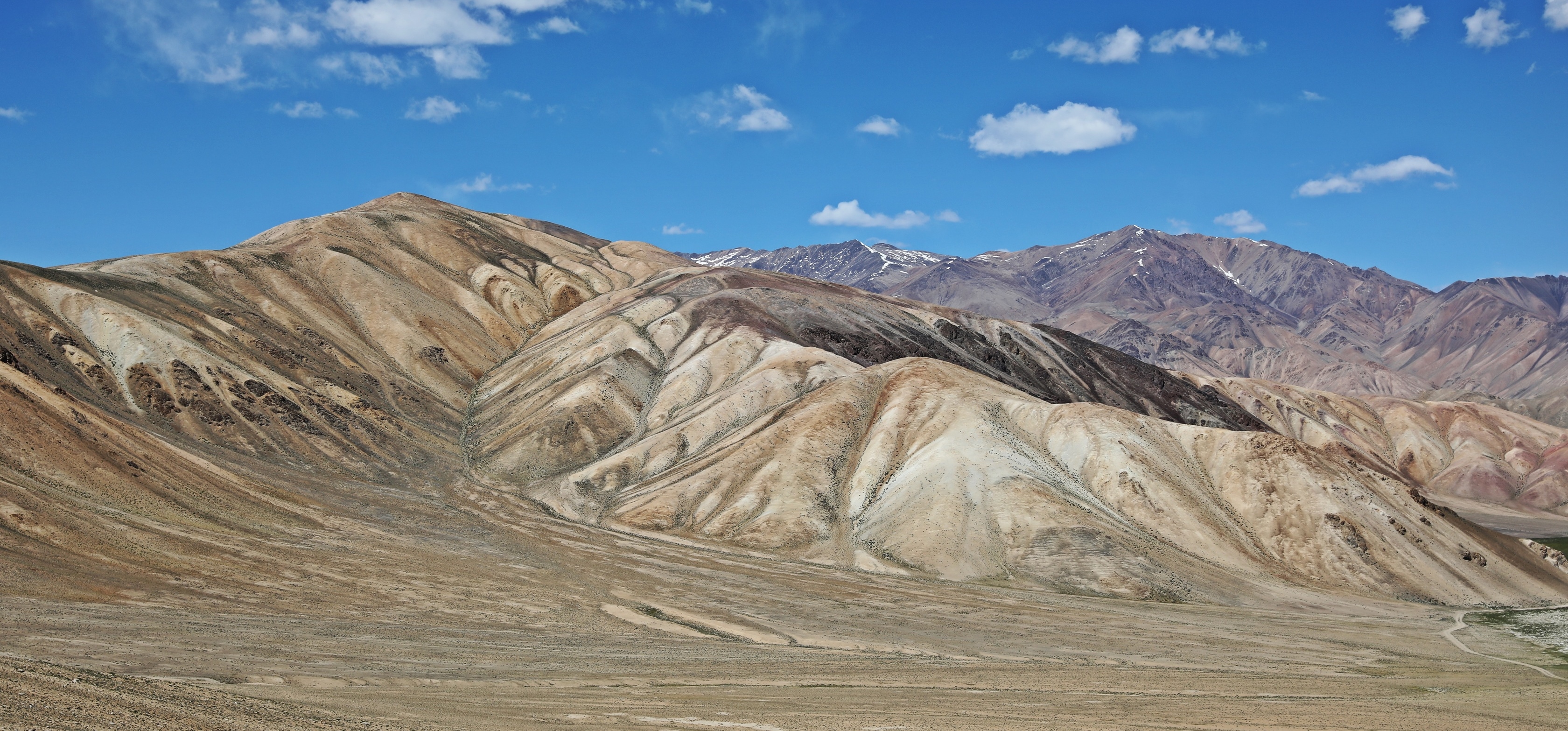
The unusual mountains surrounding the village were a wonderful surprise. They are decorated with colourful patterns as if painted by Mother Nature herself. The mountains are so unlike anything else we had seen in Tajikistan but reminded us of Hidden Valley in Ladakh, India.

Yashilkul, lies on the other side of the colourful mountains. As we walked up to the pass, the multihued lines and swirls on the mountains seemed to come to life. Their appearance transformed as our perspective on them changed. We were entranced by these colourful designs and how they played with the sun.


A small mountain pond would have been ordinary anywhere else but provided a perfect mirror to reflect these colourful peaks.


Climbing up to the pass we still didn’t know what we would see on the other side. Once we arrived, we looked down upon one of the prettiest lakes in the country.

Yashikul (Green Lake) is a large lake enveloped by arid mountains with snow-white peaks. From the top of one of the hills we had an even better view of Yashilkul and a different view of Bulunkul’s cobalt blue water.


Tip – There are a couple of multi-day trekking routes that connect Bulunkul to Bartang Valley. They cross though these gorgeous landscapes and would be an excellent addition to your trip.
Where to stay in Bulunkul – There are three guesthouses in town. You don’t need a reservation but unless you have your own car it would help if you did so you could contact them for a ride from the highway. Their contact information is on Google Maps. Rooms are obviously very basic, but ours was clean and warm. The price is $20 USD per person including breakfast and dinner.
How to get to Bulunkul – The village is located 14 km off the M41 (Pamir Highway). The turn off is approximately 30 km west of Alichur. From Khorog you can take a share-taxi, but they will only drop you off at the highway. To get to Khorog from Bulunkul your guesthouse can arrange a share-taxi back.
After leaving Bulunkul we had to travel further east on the Pamir Highway to catch our next ride. Since we had amazing views in Bulunkul, we wanted to see if those interesting mountains extended east. Unfortunately, what we saw was a continuation of the desert we had seen on the drive in. Other than one beautiful lake, it didn’t seem like an appealing part of the mountains. This is stretch of highway used to be commonly driven when road tripping from Osh, Kyrgyzstan to Dushanbe, Tajikistan. With the Tajik-Kyrgyz highway closed, this area doesn’t see as much traffic.

While we waited for our ride in Alichur we were invited to have tea with a local family. They told us that the communities in this part of the Pamirs are mostly ethnic Kygryz. They said that the further east you travel toward Kyrgyzstan, the higher the percentage of Kyrgyz versus Tajik.

We didn’t travel any further east than Alichur and had heard that the remainder of the towns do not hold much interest. One of the main reasons a few people still travel there is to cross the 4,273 m (14,20 ft) high Koitezak Pass. It is the highest point on Khorog-Osh highway which made Pamir Highway the second highest International road in the world.
Tip – Instead of returning to Khorog, it is possible to drive from Bulunkul to the Wakhan Valley on a rough gravel road. Google Maps doesn’t seem to know about it, but it allows you to make a circular loop to include both Pamir Highway and Wakhan. Details will be in our Wakhan Valley post. (Coming Soon)
We still have only competed half of our Pamir Road trip. Learning about the unique culture of the Wakhi people first hand was a large part of the draw for the second half of our trip. We spent 5 days exploring the traditional villages and ancient ruins of the Wakhan Valley from Ishkashim to Langar. This area was so special that we will spend an entire post describing what we saw. (Coming Soon)
Guide for Independent Travel on Pamir Highway
Transportation Options On Pamir Highway
Private Driver – The most common but most expensive option is to hire a private driver. In 2023 they typically charge $120 USD per day. Most trips are 10 days long. If you can find people to share it helps cut your costs, but that’s not always possible.
Self Drive – Some people rent their own 4×4 and drive themselves. We met people who had a lot of problems when the vehicle broke down. Getting it fixed in the Pamirs is next to impossible and the rental agencies charge exorbitant fees to tow, repair and providing a replacement vehicle.
Bicycle – A longtime favourite method of transportation along the Pamir is by bicycle. A large section of the road between Duschanbe and Khorog is a very rough, gravel road. Unless you like dust and are used to bumpy roads with no shoulder, and fast driving 4WDs on a time schedule, then you may want to look at other options. We mountain bike a lot, but most of the Pamirs did not seem like the ideal road biking venue.
Share-Taxi/Taxi/Hitchhike – This last option is what we did. With a combination of share and private taxis and hitchhiking from town to town we had an inexpensive and fun way to explore this fascinating part of Tajikistan. share-taxis:
Here is information on share-taxis:
• Between Dushanbe and Khorog – In both cities your hotel will help you arrange share-jeeps. Otherwise in Dushanbe go to the share-taxi stand called Badakhshanskaya Avstostansiya, you can find it on Maps.Me. On Google Maps it’s called Taxi to Pamir. In Khorog you can go to the share-taxi stand on the west end of town. In August 2023, the standard price was 400 TJS/$36 USD for a middle seat. It is more expensive to sit in the front and cheaper to sit in the back seat.
• Between Rushon and Khorog – At the share-taxis stand in Rushon we were told that the price is 500 TJS ($46 USD). We knew this was too much so we left the share-taxi stand and met a Pamiri woman who was also looking for a taxi. We shared a regular taxi with her for 300 TJS ($27 USD).
• Between Bulunkul and Khorog – Our guesthouse owner in Bulunkul arranged for us to take a share-taxi to Khorog. We had to meet the taxi in the town of Alichur. He drove us to this town for 100 TJS ($9 USD). The share-taxi to Khorog was 360 TJS ($33 USD). You could do the reverse to reach Bulunkul from Khorog
Other Information
• Hitchhiking – This is a very common, safe and affordable way to get between towns. It’s not very common to hitchhike long distances though. Most drivers expect to be paid and it’s easier if you ask how much they expect before getting in. There isn’t a lot of traffic, but almost anyone who has room in their car will stop.
• Luggage – To make it easier to get share-taxis and hitchhiking rides we only brought small packsacks for our 10 day trip through the Pamirs. We were able to leave our large bags at our hotel in Dushanbe.
• Guesthouses/Homestays – Most of the towns and villages have one or two guesthouses or homestays. They usually include breakfast and dinner in their price. Some can be found on Google Maps, others you may need to ask when you arrive. They will be basic accommodation, but from our experience, most will be very clean and serve delicious home cooked meals.
• ATMs – Take out enough money for the entire trip in Dushanbe before you leave. There are a few ATMs in Khorog and a few scattered in some of the small towns. They are not reliable though for international cards and often don’t have money. They have a cash-based economy so don’t expect to use a credit card.
• Internet – There is very little cellular coverage in the Pamirs so download any maps or other information ahead of time.
• Safety – Because the area is very close to Afghanistan we had concerns that it may not be safe. What we found was an area that is completely safe for tourists and for the people who live there. Soldiers from the Tajik army are constantly patrolling the area along the river to ensure that it remains safe. In the past there have been hostilities between Pamiris and the Tajik government. This seems to have settled down now, but conditions can change so check with local reports before leaving on your trip.
• Altitude – The Pamir Highway travels through mountain passes that are over 3,000 m (9,800 ft). Many towns and villages are also located at high elevation. If you are not acclimatized before arriving you need to watch for symptoms of high altitude sickness, drink plenty of water and give your body time to adjust. If you have symptoms you should go to a lower elevation.
• What to wear – The people who live in the Pamirs are more liberal than the rest of Tajikistan, but it is still a conservative country. Women and men should wear long pants, t-shirts or long sleeve tops. Shorts and tank tops are not appropriate. It is also a mountainous region so even in the summer, temperatures will be warm during the day, but cool at night. Bring a jacket and sweater. Good walking shoes are very important.
• When to visit – Summer (Mid June to Mid September) is the best weather to travel to this region. Travelling when there is still snow may be very difficult or impossible.
Our costs for independent travel in Pamirs
For our 10 day trip along Pamir Highway and Wakhan Valley we spent 6,780 TJS ($615 USD) for two people. The 10 day trip with a private driver would have cost at least $2,400 USD for two people.
Transportation – In 10 days our transportation costs for the trip were 2,600 TJS ($235 USD).
Accommodation and meals – Lodging and meals for 10 nights cost us 4,180 TJS ($380 USD). We chose to stay in a moderately priced hotel in Khorog. There are cheaper options in town.
Getting a Visa and GBAO permit
You need a permit to travel in the Gorno-Badakhshan Autonomous Oblast. Your permits will be checked at a few spots along the Pamir Highway and in the village of Vrang in Wakhan Valley. If you will be arriving in Tajikistan over a ground border you will need to have an e-visa. You can apply for the GBAO Permit at the same time you apply for the e-visa. If you are flying into Tajikistan you can get a visa on arrival but you will have to get a GBAO permit in either Dushanbe or Khorog and it take 5-7 days. Take a few paper copies with you because some police and army check stops want to keep them.

Click on the link to read our Travel Tips For Tajikistan.
To read more of our adventures in Tajikistan click here.
Coming Next – Trekking in Jisev Valley
For pictures from other blogs go to Gallery at monkeystale.ca
To read about more of our adventures go to Destinations.
If you like what you read, please comment or share (with credit) using the links below.


We'd love to hear from you, please leave a comment.