
Being able to cast our eyes on the majestic K2 was something we have dreamt of doing for a long time. At last we were here; walking up Baltoro Glacier on the K2 Base Camp Trek. Reaching Concordia near the start of Baltoro would be our first opportunity to see this mountain in person. Having had so many gorgeous mountain views on our first four days of the trek, we were still unsure if the mighty K2 would reveal itself to us.
In case you missed it, here’s the link to the first four days of our trek, Part I: Baltoro Glacier. Now we are embarking on the next section of our journey to K2 Base Camp.

Day 5 – Urdukas to Goro II
Distance – 11 km (6.8 miles); Trekking Time – 4 ½ hours
Elevation Gain – 308 m (1,010 ft); Elevation Loss – 100 m (328 ft); Absolute Elevation Gain – 212 m (696 ft)
Elevation at Goro II – 4,283 m (14,052 ft)
After a rainstorm overnight, we woke to a very muddy Urdukas Camp. The skies were still grey, but the ominous clouds added a mysterious feel to the landscape. The deep crevasses seemed to be more dramatic and eerie in the low light.


The hike today took us from the lateral moraine to the middle of the wide glacier. There was less up and down climbing on the trail, but there was also less rock covering the ice. Water from glacier melt ran along the path. In a few areas, where the ice was exposed, it was quite slippery and we had to watch our footing a little more. We skirted around large crevasses, but had to jump over a few smaller ones. It was very impressive to watch the mules cross them.

Soon we were walking beside the 7,821 m (25,659 ft) high peak Masherbrum (K1). The clouds were trying to obscure its summit, but we stood by patiently until eventually it showed itself to us. On our way back down a few days later, Masherbrum was completely free of cloud and we could see the entirety of the beautiful massif.
Our group was so focused on seeing Masherbrum that we almost missed our first sighting of Younghusband Glacier on the other side of Baltoro. It was first crossed in 1888 by Francis Younghusband. At its side is Muztagh Tower, but this mountain remained behind a curtain of cloud.


As we started moving up Baltoro again, Gasherbrum IV and Broad Peak were starting to emerge from the clouds. Eventually, Broad Peak showed us the wide summit ridge that gave the mountain its name. Across from it we could see the pointy Mitre Peak (6,010 m/19718 ft). Behind us, the clouds were also beginning to disperse. We were in the middle of 360 degrees of wonder. In no direction did we have a bad view. This glacier keeps delivering.


During the afternoon however, grey clouds moved up the valley. It began to rain and the mountains were covered in thick, dark clouds. Our beautiful views were gone. The rain continued for most of our walk to Goro II Camp. Only for a brief period could we see any of the peaks that surrounded us.
Tonight was the first time our camp was set up directly on the glacier. There were no exposed crevasses so there was no danger. The main problem was that it is much colder sleeping on ice than it is on the ground. We were to spend the next few nights sleeping on the cold, icy glacier.

Day 6 – Goro II to Concordia
Distance – 13.5 km (8 ½ miles) ; Trekking Time – 4 ½ hours
Elevation Gain – 291 m (955 ft); Elevation Loss – 0 m ; Absolute Elevation Gain – 291 m (955 ft)
Elevation at Concordia – 4,574 m (15,007 ft)
The clouds did not lift overnight. In fact, they fell even lower. The view from Goro II campsite remained a mystery. It began to rain early in the morning and continued to rain off and on throughout the day. It was quite miserable.
Shortly after leaving camp, the trail weaved its way between large seracs. Unlike many seracs these are all stable with large bases therefore, we weren’t in danger of a serac collapsing as we walked beside. This was the only interesting part of the cloudy day. Without a view, the rest of the hike was rather monotonous.


As we walked, we began to realize the shear size of Baltoro Glacier. We had already spent four days trekking up it and still had not reached its end. At home in Canada we have large ice fields that link different glaciers together, but none of the glaciers are even close to being as large as Baltoro. With so many gorgeous mountains bordering its side, even with all of the bad weather, it’s not difficult to appreciate that this is a very special place.
Concordia Camp is located where Baltoro confluences with Upper Boltoro Glacier and Goodwin Austin Glacier joins on their side. As we neared Concordia Camp, we could see the light brown rocks on Goodwin Austen Glacier. This lighter coloured moraine adds contrast to the grey scree we had been walking on for the last four days.


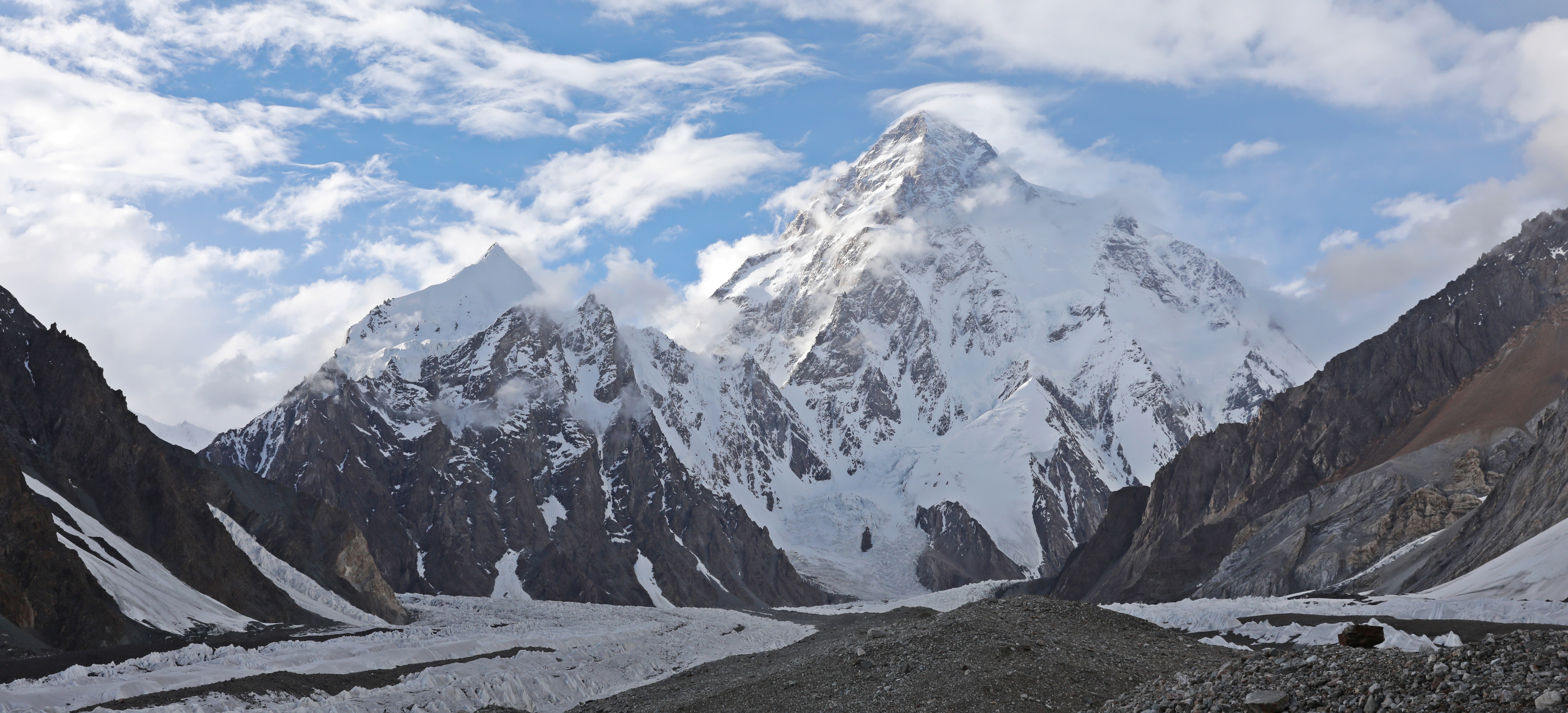
K2, the world’s second highest peak, lies at the end of Goodwin Austin Glacier. Once we arrived at camp we were treated to a teaser view of its summit. K2 seemed to be trying to poke its head out from behind the clouds to welcome us, but just as quickly, it hid again behind their cover. Beside it, Broad Peak started showing us more of its convoluted face.


After the teaser view we were very excited to see more of this famous mountain. Our entire group patiently waited; hoping for another glimpse. Miraculously, the clouds that had been shielding K2 began to lift and we were allowed to see more and more of this spectacular giant. The mountain stands alone at the end of a valley and without clouds, we could see most of its perfect triangular shape.

The tents were set up before we knew where exactly K2 was situated. We picked the one that we thought may have a good view of it from from the tent door. Once K2 showed itself to us, we couldn’t believe our luck. The view from our tent was the best we’ve ever had.
The name K2 is rather plain especially considering its stature. It received this name in 1856 when parts of India were being surveyed by the British Army. One officer could see two tall peaks over 200 km away. He named them K1 and K2 because they were in the Karakoram Range. K1 goes by the name Masherbrum, but the name K2, seemed to stick rather than its local names.


After awhile all of the mountains surrounding camp were in full view. It was magical. The camp is surrounded by so many gorgeous, high peaks, it easily became apparent why its called one of the most beautiful campsites in the world. Set in between beauties such as K2, Broad Peak, Gasherbrum IV and Mitre Peak, Concordia has the ultimate mountain lover’s location.


Here’s a short pan of the 360° of views from Concordia Camp.
Day 7 – Concordia to Broad Peak Base Camp
Distance – 5 km (3 miles); Trekking Time – 2 ½ hours
Elevation Gain – 233 m (764 ft); Elevation Loss – 56 m (184 ft); Absolute Elevation Gain – 332 m (1,089 ft)
Elevation at Broad Peak Base Camp – 4,844 m (15,892 ft)
With the cloudy skies and frequent rain that we had had on this trip, we weren’t sure what we would be able to do or see today. Luckily, the weather gods shone on us and we had a beautiful, blue sky. We thought we were going to spend tonight in K2 Base Camp, but our guides told us that instead, we would stay at Broad Peak Base Camp. They said we would visit K2 Base Camp and Gilkey Memorial as a side trip. It was initially a disappointment, but in the long run, the view from Broad Peak is much better than the view we would have had from K2 Base Camp.

Leaving Concordia Camp, the trail took us toward the Goodwin Austen Glacier. In between the two glaciers was a small crevasse and tall seracs that we had to cross. The seracs weren’t very steep, but our guides set up a make-shift fixed rope. We donned our crampons and climbed up and over. From the top of the serac we had an unimpeded view of the imposing K2 and Goodwin Austen Glacier that lies in front of it.


Our porters put us all to shame though by climbing over the slippery serac in their street shoes.


On the other side of the serac we were back on the undulating, debris covered glacier all the way to Broad Peak Base Camp. This time however, K2 was standing right in front of us. The views of it were so clear that we could make out famous parts of the Abruzzi Spur route such as the Bottleneck, House’s Chimney and Black Pyramid. We even learned of a new part of this view. The small peak in front of K2 is named K2’s Son. It was incredible to be this close to such a magnificent mountain.


Broad Peak Base camp to K2 Base camp and Gilkey Memorial return
Distance – 10.7 km (6.6 miles); Trekking Time – 3 ¾ hours
Elevation Gain & Loss – 386 m (1,266 ft); Absolute Elevation Gain – 386 m (1,266 ft)
Elevation at Art Gilkey Memorial – 5,230 m (17,159 ft)
After having lunch at Broad Peak Base Camp we set out for a day trip to K2. The walking was initially a lot easier because we could walk on the flat Goodwin Austen Glacier and not the undulating mess of Baltoro.


Once we got to the base of the mountain we scaled up a steep section to reach Art Gilkey Memorial. We came here to pay our respects for fallen climbers.
Visiting a climbers’ memorial is always a difficult place for us to visit. We couldn’t help but think of the wives, husbands and children who lost their spouses and parents to the mountain. It made me feel grateful that I wasn’t one of them.


From the memorial we looked down upon K2 Base Camp. Even though it was getting late in the season, it was still busy with climbers. The camp is very spread out under the mountain and not as spectacular as Everest Base Camp. Or maybe we’re just biased (Read Richard’s Everest Summit here).


After visiting the memorial, we retraced our footsteps back to Broad Peak Base Camp where we’d spend the night. On the way, we kept looking back for more spectacular views of this mountain.

Day 8 – Broad Peak Base Camp to Concordia
Distance – 5 km (3 miles); Trekking Time – 2 hours
Elevation Gain – 56 m (184 ft); Elevation Loss – 233 m (764 ft); Absolute Elevation Loss – 332 m (1,089 ft)
Elevation at Concordia – 4,512 m (15,007 ft)
We woke to a skiff of fresh snow on the ground, but it didn’t last long before the sun melted it away. We had an easy ‘active rest’ day hiking back to Concordia Camp. The idea was to to rest our bodies before we would climb over Gondogoro La (Pass). Our return to Concordia meant that we were able to have yet another day with these breathtaking views.
Once settled into Concordia, we were told by our guides that the forecast for tomorrow called for clouds, but no precipitation. They said that if we got to Ali Camp and the weather changed for the worse, we’d have to turn around. That would mean a long day of up to 14 hours of hiking to return to Concordia and then down Baltoro Glacier. Five of us agreed that we wanted to go to Ali Camp and understood the implications if the weather was bad. The rest of our group decided to return the way we came and not attempt the pass.
That night we were treated to a spectacular alpenglow on K2 and Broad Peak at sunset. Later, we saw the full moon above the mountains behind camp. The five of us were very excited for tomorrow.


Day 9 – Concordia to Goro I
Distance – 18.2 km (11¼ miles); Trekking Time – 6 ½ hours
Elevation Gain – 27 m (89 ft); Elevation Loss – 411 m (1,348 ft); Absolute Elevation Loss – 325 m (1,066 ft)
Elevation at Goro I – 4,187 m (13,737 ft)
We had planned to leave Concordia for Ali Camp (5,000 m) this morning. It is located just below Gondogoro La (5,600 m) which we were supposed to go over the following day. It was quite cloudy when we woke, but not more than we’d had this past week. Our guides came into the dining tent with bad news. They gave all sorts of stories on why we couldn’t go to Ali Camp. Our guides said the weather forecast for the next three days called for bad weather and that the snow would be so high it would come up to our chests. They said that the safety team who sets up the fixed ropes for the route weren’t even there. Apparently we weren’t allowed to climb the pass without them. They also told us that no other teams had crossed the pass this season. They said if we went forward, we would have no tents and no food because neither they nor the porters would be travelling to Ali Camp.

We were gutted. We weren’t able to get our own weather forecast as there was no internet, nor did we really know anything about the safety team. We did know that the weather had been notoriously bad this year. It was apparently, the worst in 14 years, so we thought they were telling us the truth. Reluctantly, we agreed and would return the way we came instead of heading up to Ali Camp.
If we were able to go over the pass we would have been able to make this a circuit hike, which is preferred. As it was, we had to make it an out and back.
The trek back to Askole would take 4 days. That was much shorter than the 6 days to climb up the valley because a lot of it was generally downhill. As well on the way up we had to take it slower to acclimatize. There was still a lot of ground to cover in two fewer days so we were to have four long days trekking. The objective for the first day was to go past Goro II Camp and stay in Goro I. Our camp ended up being so much further than Goro I, we renamed it Goro -1.
The only nice thing about the day was that we could see more of the views around Goro II that we missed on the way up including the picturesque Muztagh Tower.


Days 10 to 12 – Goro I to Askole
Total Distance – 58 km (broken down to 12, 21, 26 km each day); Total Trekking Time – 19 ½ hours
Elevation Gain – 602 m (1,975 ft); Elevation Loss – 1,734 m (5,689 ft); Absolute Elevation Loss – 1,187m (3,894 ft)
Elevation at Askole 3,000 m (9,843 ft)
Camps – Khorbutse, Bardumal
Each day we by-passed a previous camp in order to get down the mountain faster. While we were still travelling on the glacier there was a lot of elevation gain and loss even though we were generally walking down the valley. The many glacier hills that we went over on the way up were re-climbed on the way down. As an example, after leaving Goro -1 we climbed 380 m and descended 650 m in elevation even though the absolute loss was only 469 m.


Ironically with the threat of huge storms over the pass, the skies on the way down were nicer so we had better views. One benefit of that is we could see two 8,000 meter peaks that we were unable to see on the way up. We were really excited when we looked back to see the tips of Gasherbrum I (8,080m) and Gasherbrum II (8,034 m). In the picture below you can just make out their peaks behind the others.


The remaining days seemed quite monotonous. Even though we were surrounded by such beauty, our spirits were low. We ran into other trekkers, who had originally been in our group. They were from Taiwan, but because the trek takes you close to the Chinese border there was confusion with their visas. Today they told us that they met a group of trekkers in Skardu who had gone over the pass a couple of days ago. Already the lies we were told by our guides were becoming apparent.


On the return trek we paid more attention to the pretty alpine flowers and interesting bushes and trees that are able to thrive in this harsh climate.


After arriving in Askole, we still had to repeat the harrowing drive back to Skardu. We were told that a temporary bridge had been built during the two weeks of our hike. We weren’t sure if we should believe it or not. Sure enough, a small, wooden bridge had been built to cross the creek. It was a little scary, even more than the other bridges we crossed, but it held for all of our jeeps. Our porters’ truck was crammed full of people and therefore heavier, so they walked across the new bridge.


For the drive this time, instead of dark skies with swirling clouds, we had blue skies. It made the scenery appear even more spectacular.


Update – Once in Skardu we found out that at least one group crossed Gondogoro La the day after we were planning on doing it. We approached our guides and asked them to explain what the real reason was for not crossing the pass, but we were met with empty excuses.
When we arrived in Islamabad the head office had also started to hear stories of our problems. It turns out that our guides lied to them as well. We met with the owner of the company and we do feel that our complaints about our guides will be properly managed. We think part of the problem was that there were too many in our group and they couldn’t manage the split with people going both ways. Our advice to someone considering booking a trek to K2 Base Camp is to go with a small group as opposed to joining a large group (15 trekkers).
We have mixed feelings about recommending the guiding company we used. The guides clearly lied to us and prevented us from a very scenic part of the trek. The company however has managed things quite well so far and we feel that in the end they are a good company who also got stuck in a bad situation. Having said that we are still hesitant to recommend them on this blog post. If you’re interested in doing this trek you may contact us for more information on how to chose a guiding company. Our email address is monkeystale.ca@gmail.com
Trekking details
• The times listed are only trekking times. On top of these times you need to add time for several 15 minute rest breaks as well as an hour or more for lunch.
• Distances may vary from trek to trek depending on where your camp is set up.
• In July, temperatures were very hot during the day and warm at night at lower elevations, but cooler once we arrived at the glacier. At Concordia and Broad Peak Base camp it was quite chilly (near 0°C).
• Many trekking days had a lot of elevation gains and losses going up and down the valley. The elevation amounts listed are close, but may not be exact.

To read more of our hikes around the world go to Treks.
To read Richard’s Everest climb click on the links to Part 1 – Island Peak; Part 2 – Khumbu Icefall; Part 3 – The Summit Push. To read Richard’s other Seven Summit expeditions, click on Seven Summits.
Coming Next – Pakistan’s Hunza Valley
For pictures from other blogs go to Gallery at monkeystale.ca
To read about more of our adventures go to Destinations.
If you like what you read, please comment or share (with credit) using the links below.


We'd love to hear from you, please leave a comment.