Set in the coffee-rich lands, between San Salvador and Guatemala, Santa Ana is a popular destination for travellers. From hiking to the top of Santa Ana, an active volcano, to exploring historic Mayan ruins, there are a few great spots to visit on a day trip from Santa Ana, El Salvador.

Santa Ana, El Tazumal, Cerro Verde Park Inside The Blue Rectangle.

Click on the link to go directly to Travel Tips For El Salvador.

Since we were travelling in a country crammed full of volcanoes, we knew climbing to the top of one was inevitable. Hiking to the crater on top of Santa Ana Volcano is one of the most popular hikes in the country, so we decided that this would be the one. Its indigenous name is Ilamatepec. In English it means ‘Hill of the Old Woman’.

The hike begins at 1,900 m (6,200 ft) of elevation where the volcano is still covered in a dense jungle. That elevation meant the temperatures were comfortable as we began our ascent up the slope. It is required to hire a guide for the hike. The reason, we were told, is that the guide must keep a look out for one of the three types of venomous snakes that live in the jungle. Hearing this, I was more than happy to hide myself in the middle of the pack, safely away from any sightings. 

Once we climbed higher, the trees gave way to forest of agave and low shrubs. The tall flowering stalks that grow from the centre of agave plants made us think we’d hiked onto another planet.

After being mesmerized by the agave flowers, we were further struck by their contrast against the barren land that dominated the slopes a little higher.

On the way up we had a glimpse of Izalco Volcano. It’s often referred to as ‘Lighthouse of the Pacific’ because of its almost continuous eruptions between 1770 and 1958. We could barely see the volcano through the thick clouds. It along with Santa Ana and Cerro Verde are said to be the inspiration for the volcanoes in The Little Prince.

The clouds that had been low on the mountains all morning hadn’t lifted much as we neared the top. Instead of nice views of the surrounding green landscape, all we saw was the inside of a cloud. We were starting to worry that we would have climbed all this way and not see the picturesque crater lake at all.

Once we smelled the sulfur, we knew we must be getting close. After a few more steps, we reached the crater rim (2,381 m/7,812 ft). The clouds were thick so we could barely even see the outline of the colourful lake. We stood there in expectation as the clouds came and went, exposing the acidic lake little by little. And finally, just before we were supposed to descend, the clouds rose and uncovered the pretty blue-green crater lake far below.  

The colour of the lake can range from yellow-green to emerald green to turquoise due to levels of chloride-sulfate and in the water and weather.

The edge of the crater is very steep. Ropes prevent anyone from getting too close. Not only is it steep, the crater wall looks to be very unstable, composed of crumbling rock and debris. If you fell over the edge, the rock is so loose, it would be almost impossible to get back up to the rim.

There are almost 200 volcanoes in El Salvador, 20 of which are considered active. Santa Ana is an active volcano, having last erupted in 2005, which seemed a little too recent for how close we were allowed to get to it.

Here’s an 11 second pan of Santa Ana Volcano’s crater from rim to rim.

From the summit you also have views of Coatepeque Lake. This large, crater lake is very popular with El Salvador’s wealthy families whose luxury vacation homes take over most of the lakeshore. Some people stopped to visit the lake on our way back to Santa Ana. The only way to access the lake though is by having lunch or a drink on one of the few restaurants on its edge.

After 30 min at the top it was time for a quick descent down in time to catch the bus back to Santa Ana.

The hike to Santa Ana’s summit made us excited to hike to one in Guatemala. You can read about our adventure in our post Acatenango and Fuego Volcanoes Hike.

Elevation gain – 450m; Distance – 3 km (one way)
Hiking time – 1 hour 20 minutes up, 1 hour down. Plus 30 minutes at the top.
Fees – For the group hike, the guides charge $3 USD each. In addition to the guide, the park fees are $3 USD each. Armed police escort the first group up and last group down. You may also see some partway up the hike as they patrol the trail. There may be free tours that leave hourly from the park entrance, but we haven’t had that confirmed. This was not an option in the spring of 2024.
Best time to hike Santa Ana Volcano – The best hiking weather is in dry season between December to April. Rainy season runs from May to November and would not be ideal to hike. We did the hike in April and it was already very cloudy.
Park rules – Even though it’s a small three-hour hike, there are several park rules that are strictly enforced. We didn’t see any wildlife, but apparently there are foxes, tigrillo (wild cat), coyotes, numerous birds. The rules are to protect these animals. Park officials check your bags to make sure you adhere to the rules:

  • No alcohol
  • No smoking
  • No weapons
  • No pets
  • No loud music such as horns or even shouting
  • You must have a registered guide
  • You must carry all garbage out

If you have a car you can easily drive yourself to Cerro Verde National Park. Once there you can hire a private guide. Without a car, it is very easy to reach by public transportation. A bus leaves from the station ‘Sala de Espera y Abordaje’ on 11 Valle Sud at 7:30 am. It is scheduled for 7:30 but, seems to leave at 7:40. (70¢ USD). This is the common transportation by most of the backpackers in the city so it may fill up quickly.

The bus drops you off on the highway beside Cerro Verde National Park. A hiking guide for the group hike will usually meet the bus. Some on-line posts give a specific time that this group hike begins but, when we were there the hike started as soon as we got off the bus.

To return to Santa Ana, the bus will arrive at the same place on the highway around 1:00pm (ours arrived at 1:30) and 4pm. It is very easy to do the hike and still catch the 1:00 bus.


Only 18 km from Santa Ana, in the small town of Chalchuapa, is the archeological site of El Tazumal. Visiting this Mayan site can easily be done on a day trip from the city.

This region was likely originally inhabited by the Olmecs around 900 BCE, but only a few artefacts have been found from this time. The Mayans moved in centuries later, but had only been living in El Tazumal for less than a hundred years when Ilopango Volcano erupted. The 5th century eruption covered the area in volcanic ash and the Mayans were forced to flee. This resulted in a gap of a couple hundred years when no one lived in El Tazumal. It was difficult to pin down exact dates for these early years because until recently, it was believed that Ilopango Volcano erupted more than 200 years earlier than what today’s research shows.

Eventually the Mayans returned to El Tazumal and established what was to be a very important town. Most of the buildings we see today are from when it was at its largest, between 600 and 900 AD. It is believed that they shared parts of the city with Pipils who migrated to the area from Mexico in the 8th century. By the 1200s, the city was abandoned by everyone.

At the centre of the site is the large temple known as Great Pyriamid. Like many archeological sites, the buildings in El Tazumal were modified many times over the hundreds of years they were in use. The Great Pyriamid grew in both width and height as each new layer was added. No less than seven modifications were made to reach the final structure we see today.

In a tomb beneath the stairs they found pottery from as far away as Teotihuacan, near present day Mexico City. They also found skeletons of an adult and of a dog. On the top of the large temple is a stone oratory where ceremonial rituals would have taken place.

Beside the large pyramid is the oldest structure at the site. A tomb was also found in Small Temple. It was filled with jewelry, ceramics and jade as well as a skeleton with a flattened forehead. This person was likely a priest, or important leader as cranial deformation was a sign of social distinction to the Mayans.

El Tazumal isn’t a large site, but is a nice day trip if you’re in Sana Ana.

There are a few other things to do in Chalchuapa. We stopped by Laguna Cuzcachap, but found it was more of a slew than we had expected. There is also another Mayan archeological called Casa Blanca. Reports we read and heard was that there is not much to see at the site, so we didn’t visit it.

Entrance Fee – $5 USD; Opening Hours – Tuesdays to Sundays, 9 am to 4 pm

Although it is possible to visit El Tazumal from San Salvador, it is much easier from Santa Ana. Bus 202 or 218 travel to Chalchuapa where there is a bus stop is across from the archeological site. Uber from Santa Ana will cost around $6.50 USD each way.


The city of Santa Ana is still a little rough around the edges. It receives a lot of backpackers, but has not really established itself as a tourist town yet. We used it as a jumping off point to visit Santa Ana Volcano and El Tazumal and in between were able to explore a few sites that the city has to offer.

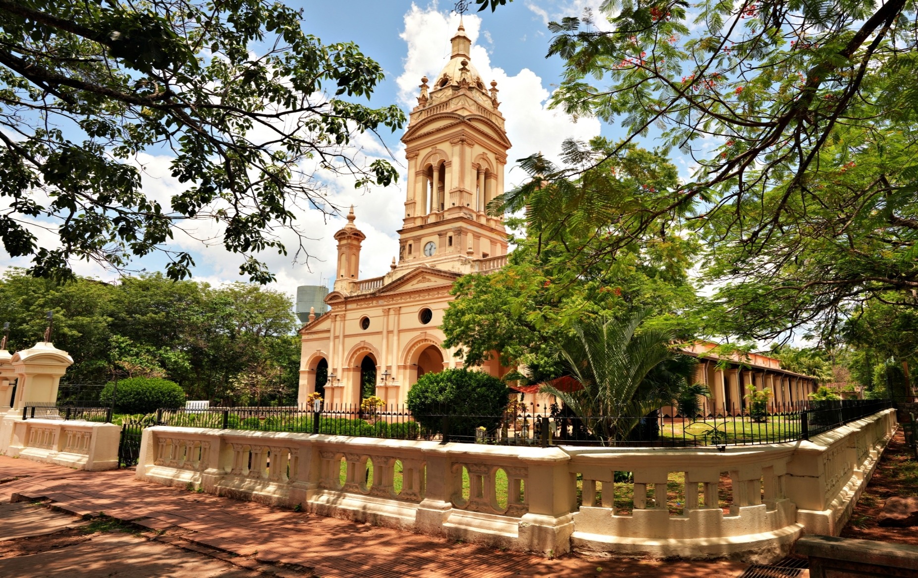
Set in the city’s centre, Parque Libertad seemed to be the busiest spot in town, both day and night. It’s a lovely treed park with several benches under shade trees to relax. Food stalls are set up around the edges of the park offering pupusas, corn and other favourite snacks. We weren’t sure though, if the sign indicating guns are prohibited should make us feel more or less safe.

This park is also home to the most beautiful buildings in the city. On one side of the park is Santa Ana Cathedral. Its tall, white ornamented spires seem a bit out of place in this modest city. In the late 1800s the original Spanish colonial church was badly damaged by a lightning strike. The façade we see today was rebuilt between 1906 and 1959. Architects purposely used a neo-Gothic design that did not look anything like a typical colonial church.

From the side you can see the original brick church. Inside, it has three long naves with vaulted barrel ceilings and tall pillars, but is much less glamourous than its exterior.

Located at 665 metres of elevation and surrounded by lush volcanic slopes Santa Ana, is in the perfect position for coffee plantations. As a result, the city was once the home to several wealthy coffee barons. The elegant Santa Ana National Theatre was opened in 1912, to cater to these nouveau riche residents. The building takes up one full side of the park’s border.

Today the historic theatre is still being used by residents of Santa Ana. We intended to tour the theatre, but instead ended up buying tickets for a matinee production. Even though it was in Spanish, we found it quite interesting. The play was called ‘Migrantes’ and theatre seats were filled with high school students. Its message to the youth of El Salvador was to not attempt to migrate to the United States, but instead stay and help re-build El Salvador. Since the news today is filled with stories of the US’ southern border crisis, we were glad to see they are trying to get the message out that migration is not the solution. 

Filling in the sides of the square are the pretty yellow Palacio Municipal (City Hall) and Cultural Centre. 

Elsewhere in the city, there is a mixture of colourful homes with clean streets and run down buildings with a lot of litter.

If you’re already in El Salvador, Santa Ana can be reached by chicken bus from many cities. There are two bus stations in the city: Terminal de buses Franciso Lara Pineda and Empresa de Buses Vencedora. Most buses for tourist destinations leave from Francisco Lara Pineda, but you should always check. This website is a great resource

There are also tourists shuttles travelling from Antigua, Guatemala to Santa Ana. Some tour offices in Antigua sell tickets.

Try to stay within a short walk of Parque Libertad. There are a few restaurants and coffee shops within a couple of blocks of the square. We enjoyed coffee and breakfast at VKoffee.

The streets around Parque Libertad seem to be quite safe during the day. We didn’t feel unsafe at all, even walking to the bus station from downtown. In fact, recent changes in government crackdowns on gang violence has made the entire country a lot safer. Even with this decrease in crime, always use safe practices such as not carrying a lot of cash or expensive jewelry or walking alone at night when travelling in El Salvador.

Read from another device.

To read more of our adventures in El Salvador, click here.

Fediverse reactions

94 responses to “Day Trips From Santa Ana, El Salvador”

  1. You two really get around. Good series, Maggie.

  2. The pyramid is a must-see. My father visited that area and brought back dozens of photos. He was gobsmacked by the artifacts.

    1. Oh that’s interesting. There are a few more Mayan pyramids coming up in Guatemala, and then much later in Mexico.

  3. I’m glad you – and thus, we – were able to get an unobscured view of that pretty volcanic lake. Interesting to see that older church subsumed by the newer white cathedral walls. A worrier by nature, that “no guns” sign in the park would make me anxious, if for no other reason than it would remind me what a dangerous country El Salvador used to be and all the what-ifs my brain would concoct around that.

    1. It’s like they tried to hide all parts of the old Spanish built church by building the front so much larger. It was all a bit over-the-top. Well, I’ll admit, I was nervous when I saw the signs. I thought, if the people still need a reminder, it’s not a good situation. But actually I think it was very safe.

  4. Wow. You often make me wish I chose the road less travelled. To volcano alone would have made the trip for me. Add everything else and the adventure is huge. Great post… but then again, they all are.

    1. Thanks, sometimes there’s a reason the road is less travelled, and sometimes its worth taking it. 🙂

  5. What beautiful destinations and what wonderful photos and descriptions!
    Thanks for sharing💝

    1. Thank you Luisa! Maggie

      1. You’re most welcome, Maggie 💝

  6. The crater lake is such a pretty colour – I’m glad the clouds parted so you could see and photograph it to share with us 🙂 And I was interested in the link between El Tazumal and Teotihuacan, having recently visited the latter.

    1. In coming Mayan sites there are other references to Teotihuacan. At this one, it was just noted, but not further explained.

  7. What a great hike, but I have a suspicion snakes are rarely sighted by hikers and it was a way for locals to make money being guides. Usually, snakes sense vibrations when we walk and slither off.

    1. It didn’t sound like a likely story, but I wasn’t taking any chances 🙂

  8. That crater lake is the most amazing colour. All those minerals certainly produce a memorable scene, especially when the clouds part to give you a good look! I’m amazed too that you would be able to get so close so soon after the last eruption.

    I’ve always found the Mayan city sites fascinating. It seems they had to abandon this one; any reason speculated?

    Great post, Maggie. Very enjoyable.

    1. I don’t think I’ve seen a lake quite that colour before so I’m really glad the clouds finally lifted. There wasn’t a lot of information on the Mayan site as to why it was abandoned. In fact they don’t know why a lot of them were. This one really seems strange because it was two different cultures who left at the same time. Even more strange that they seemed to live side-by-side peacefully for a few hundred years! Thanks Lynette 🙂 Maggie

  9. The color of the water in Crater Lake is stunning! Especially set against the black/brown color of the surrounding rocks. That must have been an amazing hike. I would love to wander around the ruins- such an interesting bridge between past and present 🙂

    1. We were so worried that we wouldn’t see the lake, but even in the cloud cover it’s quite stunning. I’m always amazed to see what these old civilizations have created. This was a small site, but no less interesting. Thanks Meg! Maggie

  10. You’re courageous to hike up the slopes of an active volcano. Glad that the clouds finally cleared so that you could see the crater lake.

    1. We hope that it’s monitored well and closed off to hikers when it’s about to erupt, but you never know. I’m glad we did it and thankfully we were able to see the lake. Thanks Rosaliene! Maggie

  11. What an amazing trip and detailed photos. I enjoyed the dream–like photos of the volcano. Just a question, is it one volcano with several craters (it looks like from your photos) or several volcanos craters that collectively carry the name Santa Ana Volcano?

    I enjoyed the short panoramic video. Great filming…very lovely view of the lake.

    El Tazumal is amazing! I forget that other places have huge pyramids similar to the well known places around the world. Thank you for the great details you included.

    Santa Ana city seems to have some development happening, that is nice to see also from the subject of the play at the theatre.

    Is the route Ruta de las Flores near Santa Ana, I wonder. Have you traveled this route?
    How was the coffee, you mentioned you had some coffee there…P.S. Places with volcanic areas seem to have the best coffee. How amazing is that.
    As always Maggie thank you for allowing readers to join in your adventures, You do so well explaining everything worthy of note. I appreciate coming alongside these virtual adventures. Safe travels. Blessing to you.

    1. There are actually several volcanoes in the small area and others that are craters from extinct volcanoes. It’s amazing how many volcanoesntheybcan fit into this country!
      We travel Ruta de Las Flores. It’s between Santa Ana and the coast. The coffee in this region is delicious. It’s rich with a hint of chocolate. There is something about volcanoes and good coffee.
      Coming soon you’ll see even taller and more interesting pyriamids. The Maya were very good pyriamid builders.

      Thanks so much for your interest Suzette! Maggie

      1. Thanks for the details and for your patience with my “interest.” I love all things travel related.
        Yes to amazing coffee from the rich volcanic soil. How natures makes its riches is truly awesome!

  12. The way by which you document these trips is rather impressive.

    1. Thank you so much! We love to share what we see around the world.

  13. It’s incredible to me that a small country has 200 volcanoes, and that 20 of them are active. Too bad that all of the snakes don’t fall into volcanoes!

    1. Haha! That would be my idea world! I read somewhere that El Salvador is the size of Massachusetts, so that is a lot of volcanoes crammed together!

  14. Another fascinating location, Maggie. I’ve hiked a few volcanos. They’re all different. Love all the pics and info. Do you ever get sick from the foods?

  15. A glimpse of you back to your hiking tricks. I loved the volcanic acid lake but was concerned when it was hidden in thick cloud. The no gun signs would have me on edge, too. Not the usual by any means.

    1. Haha yes we had a little bit of hiking on this trip! Thankfully the clouds lifted at the last minute so we could actually see the lake. The gun sign was quite disturbing, just the fact that it was needed is unsettling. But the park and the city didn’t seem unsafe. At least not when we visited. Let’s hope it stays that way for the people.

  16. Now thats a great hike!

  17. Snakes and guns; yikes! Good thing the country is safer now from gang violence. The volcanic lake is quite spectacular. The pyramid reminds me of the one in Chichen-Itza. We were fortunate to have visited over 30 years ago and it was quite deserted. I can’t imagine what it’s like now. You certainly do find the most interesting places to visit!

    1. I know! And an acidic lake too! We visited Chichen Itza too on this trip so we’ll take you back there in a few weeks. Guatemala is next, so get out your planning pencil!! 😊

  18. Glad to hear the clouds cleared and you were able to see the crater lake. The colour of the water is beautiful! The edge sounds super treacherous though. That and the part about the venomous snakes! I would want to be hiking in the middle too. 

    1. We’re not usually bothered about getting too close to the edge, but we could tell this one was very unstable and made sure we kept well behind the ropes. I wish he told us about the snakes once we were safely back down since I was more worried about them than anything else!

  19. I really enjoyed reading about your experiences hiking Santa Ana Volcano. I can’t believe it’s only a 3-hour hike though, that’s surprising! Although having an armed police escort sounds a bit intense, I guess it’s better to be safe than sorry.

    1. Thanks Ritesh, it’s a great day hike on Santa Ana. The armed guards are likely still not needed but they want to protect their valuable new tourist industry. Maggie

  20. Always love reading your hiking accounts. The agave flower stalks do look otherworldly — funny thing is I think I also said something similar when I saw the photos you took from your hike in Kenya. Speaking of Santa Ana’s last eruption, it’s actually been a long time, volcanic eruption-wise. Here in Indonesia, a volcano can be reopened to the public just weeks after its last eruption as long as all the seismic readings show no signs of imminent danger. C’est la vie. Despite its relatively small size, the Maya pyramid of El Tazumal looks neat!

    1. I guess volcanoes lead to bizarre landscapes, Mt Kenya did also seem otherworldly.
      We get to our story from a red hot volcanic eruption in a few weeks. It’s frightening to think how soon they let people get so close. Each Mayan and Mixteca site we visited were different, and each gave us something new to learn, which was nice.

  21. So much to see and do! Hiking through brilliant jungles and up the face of an active volcano, to stare into the impossibly turquoise crater lake and see the wonderful Santa Ana Volcano Crater Lake sounds like heaps of fun. It would definately be on my wish list for when I visit El Salvador. Thanks for sharing, and have a wonderful day 🙂 Aiva xx

    1. It is a great hike. You get to the top of a volcano, see a pretty lake and get back into town in the afternoon. It’s one tourist site that is very well organized. The number of young backpackers that have resulted in good services. Thanks Aiva! Maggie

  22. I’m learning so much about El Salvador from this series. The volcano hike is the highlight of this post for me, I think. The color of the lake is so bright! I have no doubt I would enjoy the hike, though I agree, it would be a little nervewracking to be on a volcano that erupted less than 20 years ago!

    1. I knew you’d like a hike to a mountain lake, even if it is acidic 😊

  23. Gotta love a volcano. Looks great, very similar to other Central American countries. Love the colour and the variety.

    1. I remember your volcano post a while ago, there are a few waiting for you down there. So glad we didn’t walk up for nothing and got a view of the lake. All of these countries are similar in many ways aren’t they? El Slavador is the least developed that we’ve seen, but we haven’t been to Nicaragua or Honduras yet.

  24. That volcano is amassing and you were able to get so close. The buildings in Santa Ana are well preserved.

    1. It’s pretty cool to be on the crater of an active volcano – we hike to a fiery red one soon too:) You can tell that Santa Ana used to be quite wealthy with it’s elegant old buildings. It’s not quite ready for a lot of tourists yet, but hopefully one day El Salvador will be more settled. Thanks! Maggie

      1. Glad you enjoyed El Salvador, we did as well, despite its tragic history and being rough around the edges! I think a lot of people would not like it. One must look for the diamonds in the rough. But that is a part of traveling. Cheers

        1. That’s true and also it’s okay that it’s not for everyone. 😊

  25. What an incredible experience! Thank you for sharing – your photos, as always, are spectacular. Looks like a great one to add to the dream travel wish. 🙏🏻

    1. Thanks Michele, glad you enjoyed El Salvador with us 🙂 Maggie

      1. You’re welcome, thank you Maggie! I bookmarked that one. 🙏🏻

  26. It looks wonderful – especially the Santa Ana Volcano Crater Lake. You’re really making me consider a central American trip 🙂 Did you find you needed a decent level of Spanish to navigate and get around?

    1. There’s a lot to see in Central America! A basic level of Spanish is enough in most countries, but if you go away from the tourist sites there’s not much English. Our Spanish improves with each trip, but we still only have a very basic level and we get by.

  27. This jumped out at me first: cranial deformation was a sign of social distinction to the Mayans. Human being are so weird. The things we do to our bodies, and the things we believe, and preach others to believe. Truly SMH.
    Your volcano climb reminds me of climbing Cotopaxi – same weather, so no glorious views.
    I love that the kids are being taught that migrating is not the answer.
    Alison

  28. I’d certainly like to visit El Tazumal, which seems to have been well restored. Santa Ana resembles many of the small towns in the region, but it’s true that the security issue continues to hamper the development of tourism, which is a shame.

    1. El Tazumal is small, but it’s a good site. Santa Ana is a little rougher and more run-down than most of the other cities in Central America, but hopefully, it will clean up a little someday and be more of an interest to travellers. Maggie

  29. I’m glad the cloud lifted so you could see the crater lake, it would’ve been a shame to go all that way without seeing it. Although it looks rather eerie and forbidding. The buildings in Santa Ana are beautiful and so full of character. The cathedral’s facade, in particular, is stunning!

  30. I would be nervous about seeing a snake! Glad the clouds lifted so you could see that gorgeous water. I didn’t realize there were so many volcanoes in El Salvador.

    1. There isn’t much flat land in the country – it’s all volcano. I would have been quite upset if we hiked all the way up and still couldn’t see the lake. As it was it was only a quick view, but enough I guess. Thanks Lyssy! Maggie

  31. Cool color lake! Careful being in the middle of the pack with 🐍. I hear the first one wakes it, the second irritated it, and the third one gets bit! 🤣🤣. Don’t know if that is true, but a guide told my dad that in Costa Rica!

    1. Yikes, I’ll keep that in mind!

  32. Love those misty views down into the volcano, Maggie, and there’s some lovely architecture.

    1. Thanks Jo, it was an impressive view 🙂 Maggie

  33. Loved the volcano video!!!

    1. Thank you! It was a fun hike. 😊

    1. That’s funny. Seems they’re not too original in either counrry with naming Volcanoes 😊

  34. A bit terrifying to look down into a volcano, isn’t it? I remember doing so in Costa Rica, and hiking amid smoking lava in Guatemala. Enjoyed learning more about El Salvador from your detailed posts.

    1. We did a much more scary one in Guatemala, Fuego. But it is all still quite unnerving, especially the steep crater wall. 😊

      1. Cool! I hiked Pacaya a few times. It seemed that that was the place everyone wanted to go at the time. Looking forward to your Guate stories!

  35. […] Coming Next – Day Trips From Santa Ana, El Salvador […]

  36. I’m glad the volcano was quiescent!

    I still remember when I saw my first agave in a desert in New Mexico. It felt as though we had entered a completely different world.

    1. Yes, it was nice to see the lake, but we were pretty close so glad there was no eruption. Aren’t the agave interesting plants? Their tall flowering stems really make the landscape other worldly.

      1. Otherworldly indeed. And complementing these beautiful flowers were colorful tanagers and orioles, also sporting shades of yellow and orange. 😊

  37. My respect to you for climbing up to the crater to see that lake. That must have been quite the experience.

    1. It was a great hike, once we finally were able to see the lake anyway! Maggie

  38. Enjoyed your recounting of the volcano hike. The crater lake photos are fabulous. Cheers, Mark

  39. […] Norte, Ecuador; Aconcagua, Argentina; Elbrus, Russia; Kilimanjaro, Tanzania; Mt. Kenya, Kenya; Santa Ana, El […]

  40. […] El Salvador – One of the most unique Mayan sites is in El Salvador. Joya De Cerén is a Mayan city that was covered in volcanic ash in the 6th century. You can read more about this fascinating site in our post How To Spend A Day In San Salvador. Or visit the pyramids of El Tazumal on a Day Trips From Santa Ana. […]

  41. looks like a very doable volcano hike. thanks for the info. Santa Ana is definitely a town that seems to be a good base in El Salvador. Thanks for sharing!

    1. The hike is very doable and very popular with the backpacking crowd, but it’s a nice hike if the weather cooperates. Santa Ana itself is not overly cute but you can use it to access other places.

  42. […] more information on Maya sites, visit our posts about: Maya Ruins In Belize; El Tazumal, Joya De Cerén in El Salvador; Tikal & Yaxha in Guatemala; and Palenque, Chichen Itza, Uxmal […]

  43. Wow, Maggie. Thanks for directing me to this post which gives me a lot more good ideas of places to visit in El Salvador. The town of Santa Ana looks pretty, even if it is “rough around the edges” and the El Tazumal ruins look very interesting (I love that sprawling pyramid). That crater lake is a pretty color and would be fun to see; we saw a lake like that in the Andes in Ecuador, Laguna Quilotoa, which you could climb down to (it wasn’t easy). I think the hike you did might scare me a bit, especially for the venomous snakes, but also for the steep and unstable walls of the crater. I’m not sure I would be as brave as you!

    Here’s my Laguna Quilotoa post: Latacunga, Tigua and Laguna Quilotoa

    I’m curious, as you seem to have traveled much around Latin America, I wonder if you’ve been there.

  44. Darn! I just wrote a long response to this post and then WordPress made me sign in and the post disappeared. Anyway, I thanked you for directing me to this post because you laid out more places for me to visit in El Salvador. The El Tazumal ruins look interesting, especially that sprawling pyramid, and Santa Ana looks clean, colorful and interesting despite being “rough around the edges.” I’m not sure I’d be as brave as you in climbing the Santa Ana Volcano, because of both the venomous snakes and the unstable walls of the crater. I love the color of the lake at the bottom of the crater. I saw a similar one in Ecuador in the Andes: https://wanderessence.com/2022/11/09/latacunga-tigua-laguna-quilotoa/

    I wonder if you’ve been there?

    1. This was in spam, so wasn’t completely lost. We didn’t see Laguna Quilotoa, it looks gorgeous. We climbed Cotopaxi though which you said is near by. Because we were climbing three volcanoes on that trip we didn’t really see a lot of the other sites. Always a reason to return 🙂 Maggie

  45. The crater lake look fantastic! Hope the guides are really good in spotting the snakes! Have you heard if there was any particular case of an issue with them?

    1. I didn’t ask. I didn’t want to know!

      1. Haha, I wouldn’t want to know either LOL

  46. […] To read more about El Tazumal, visit our post Day Trips From Santa Ana. […]

We'd love to hear from you, please leave a comment.

Destinations

Discover more from Monkey's Tale

Subscribe now to keep reading and get access to the full archive.

Continue reading