
If you’re in Málaga, Spain and feel like being a little adventurous, you may want to hike El Caminito del Rey. This popular route is a fun walk on a suspended path that travels high above a narrow canyon. Come with us as we take you along this lofty trail.
As we drove up the winding road to the canyon, clouds swirled in the valley ahead. It had rained for the past few days so we wondered how this iconic hike would turn out today. Would we be rained out, or would luck be on our side?

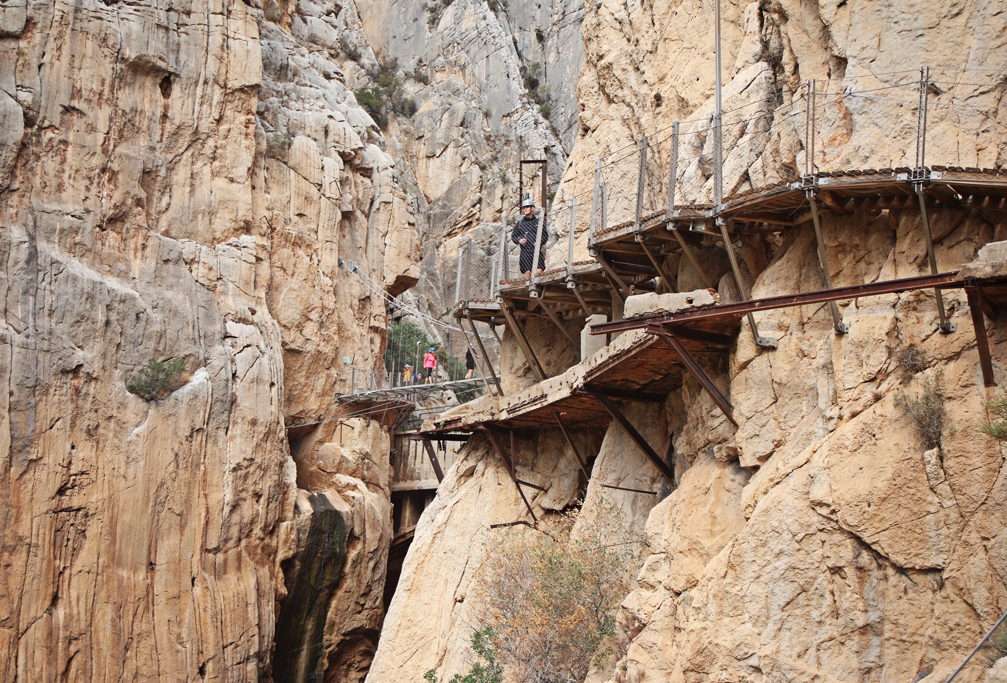
The original path in Gaitanejo Gorge is often called one of the deadliest routes in the world. Rickety platforms were built on the steep canyon walls, suspended high above the Guadalhorce River. At that time, it was the only option for workers to walk between different sections of the dam. El Caminito del Rey translates in English to The King’s Little Path. Our guide gave us a slightly different interpretation. He said ‘El Caminito’ means ‘tiny platform’. That seems a fitting description for the original path that was only 1 m (3 ¼ ft) wide. Not only was it narrow, but it was full of holes. Adding to the danger, handrails were only knee-high. This was because workers often led donkeys along these platforms. The donkeys, laden with heavy packs, were too wide to allow the railing to be any higher.
This dangerous route was used from 1901 until the 1970s when the dam was closed. Even after the dam’s closure, locals continued to use these paths. Instead of using it for work, it was their recreation. They hiked and sometimes even rode motorcycles on this precipitous trail.


Today, the Caminito del Rey is not dangerous at all. The newly built platform is quite wide and has sturdy safety rails. It is a solid walkway, but the 7.7 km (4.8 miles) long path does still cling to the side of the tall cliffs for most of its length. At times, we were suspended 100 m (330 ft) above the Guadalhorce River, so people with a fear of heights may not enjoy the hike.
This new platform was built above the old one. Upon seeing the rickety one below us, we were glad we weren’t walking on it.


The trail first travels through a very narrow section of the gorge, called Tajo de las Palomas. From this stable platform you can comfortably appreciate the beauty of these 700 m (2,300 ft) tall cliffs. If you’re not afraid of heights you can look over the side to see the river far below.


Not long into the trail you reach King’s Bridge. The trail is named ‘El Rey’ because King Alfonso XIII walked on the original path when it was still under construction. At that time, only 700 m (2,300 ft) of platform was completed. The bridge where he turned around was named King’s Bridge after his visit. Just as we arrived at the bridge, a train passed by on the other side of the gorge. We didn’t realize the Seville-Málaga train travelled right through the canyon. Although it went by quickly, it made us realize that taking the train would be a fun way to see the canyon.


In the middle of the hike, the canyon opens up and the trail moves from the hanging platforms to terra firma. We were surprised to see a variety of trees growing in the most unlikely places. There were small forests of oleander, juniper, Aleppo pine, eucalyptus, willow and ash. We were told it is a stunning scene in the spring when the oleander is in bloom. Some of the trees were planted to prevent rock fall, others naturally grow in this harsh landscape.


The second section of the suspended path goes through Los Gaitanes Canyon. Here, we saw an area with Jurassic-age fossils, high above us on the cliffs.

There are quite a few rock climbing routes in this section of the canyon. We could see bolted routes following the cracks and buttresses of the tall walls. Once the new tourist route was opened in 2015, climbing was prohibited. It’s too bad because the limestone looks very good for climbing. There is only one small cove on the other side of the river where climbing is still allowed.

Finally, we reached the most famous viewpoint. At the end of the Caminito, a suspension bridge connects the two sides of the steep canyon. You can still see traces of the old bridge below it.
We were very happy to have made it to the end and it hadn’t rained on us after all.


Although El Caminito del Rey is not difficult or dangerous, the gorge is very pretty and the suspended path offers a unique way to see it. Be aware though, it is very touristy.
Tips for Caminito del Rey
- There is a large parking lot outside the park. From there, a shuttle bus takes you closer, but you still have a 1 ½ km walk to the park entrance. In October, because it was less busy, we could drive to a free parking lot closer to the entrance. The shuttle also stops at the train station.
- At the end of the hike, shuttles take you back to the parking lots and train station.
- It is a very popular tourist activity, so buy your tickets in advance. One good thing is since entries are timed, the trail never feels too crowded.
- There are both guided and self-guided tickets. When we booked, all the self-guided spots were taken so, we booked a guided tour. We looked at dates for the rest of October and there were no self-guided tickets available. It was strange because there didn’t seem to be anyone on a self-guided ticket when we were there. We think the guiding companies book these tickets.
- All hikers must wear a helmet in case of rock fall, but they were likely not necessary.
How to get to El Caminito del Rey
Located only 50 km from Málaga in one direction and 60 km from Ronda in the other, you could easily do this hike as a day trip from either city. The drive is on double-lane highways for most of the trip, but they are in good condition. If you don’t have a car, you can take the train from Málaga or join a tour. There are several tours offered on-line from Málaga.
El Caminito del Rey is located very close to Antequera on the map below. Click on the map for an expanded view.


To read about other hikes we’ve done around the world, go to Treks.
To read more of our adventures in Spain, click here.
Coming Next – Costa del Sol – Frigiliana & Nerja
For pictures from other blogs go to Gallery at monkeystale.ca
To read about more of our adventures go to Destinations.
If you like what you read, please comment or share (with credit) using the links below.


We'd love to hear from you, please leave a comment.