
Being located on the edge of the Rocky Mountains, means that mountain biking is a popular sport in Calgary. As a result, there is a large selection of trails to choose from, both in the city of Calgary and a short drive away. We’ve been biking in this area for years and have come up with our favourite X-Country and singletrack mountain biking trails in the area.
We love X-Country because you can cover a long distance and enjoy amazing views, while getting a great workout. Some of these trails can be hiked, but you wouldn’t be able to cover as much distance on foot as you can on a bike. This list is intended for others who love singletrack or X-Country mountain biking. It is not intended to be a guide, but rather a brief description of the trails so you can decide where you want to ride.
- Click to go directly to trails in:
Calgary

Paskapoo Slopes
Type – Singletrack, X-Country
Our favourite local spot has trails that climb up and down the 155 m high ridge beside WinSport. Paskapoo Slopes area (also called Eastlands) has a variety of trails from breezy rides on flat, wide trails, to steep downhill runs with sharp turns, plenty of roots and a few jumps. Some trails are rough, most are without berms and the trees are tight, but with over 77 trails to choose from, you’re bound to find something you love.
There may be wildlife (deer, moose) on the trails, so be aware.


Access – You can access the trails from the top or bottom of the ridge. From the top, there are a few access points in Cougar Ridge or from the pathway system in the community of Patterson. Near the bottom, there’s a parking lot above Trinity Hill Shopping Mall on Pita Rise SW. It’s called ‘Paskapoo Parking’ on Google Maps. Where you start depends if you want your climb at the beginning or end of your ride. There’s no fee to bike or park here.
12 Mile Coulee Park
Type – Singletrack
Our second favourite bike trails in the city are in 12 Mile Coulee. It has a couple of long, singletrack trails that travel the length of the coulee. With 110 m elevation gain, it’s not technical, but it is fun. The well designed trails have banked corners and steep, short climbs. The trail is shared by runners and walkers, so you must always be on the lookout. It’s located in the green space along the edge of Stoney Trail NW and Nose Hill Dr. NW.
There may be wildlife (deer, moose) on the trails, so be aware.


Access – You can start at either end of the coulee. There is street parking in the community of Tuscany, or parking at Tuscany Market Shopping Mall. You can also combine it with Bowmont trails and park in its nearby parking lot. There’s no fee to bike or park here.
Bowmont Park
Type – X-Country, Singletrack
Bowmont Park fills in the slopes between Silver Springs and the Bow River. With two dozen singletrack trails, you have quite a few options right in the city. There are a few steep climbs and descents, but a lot of the trails are quite flowy. The most unique trail is Sideshow Bob. It’s an exposed singletrack trail with blind corners and a rollercoaster feel. It’s a lot of fun and only runs east to west to prevent collisions.


Access – There are two parking lots off 85 St. NW, one off 54 Ave. NW, and another off 52nd St NW as well as in the off-leash areas. Since the trails are connected, you can park at whichever is most convenient for you. There’s no fee to bike or park here.
WinSport Bike Park
Type – Downhill
Taking over the ski hill in the summer are the steep trails at WinSport Bike Park. Their runs are mostly downhill and have with professionally made jumps and berms that are accessed by the chairlifts. There are a few easy trails, but most are quite technical and require downhill experience.
On weekdays, the park may be busy with summer camps. You require a lift ticket to bike at the park.

Nose Hill Park
Type – X-Country
This large park has sixty kilometres of trails that travel through native grasslands on a mix of paved and dirt trails and offer gorgeous city views. Most trails on Nose Hill are not very technical, but there are a few with long climbs to help you get in shape for the season. For more challenging rides, you can find a few steep descents and climbs in the coulees.
Remember to share the trails because the park is very popular with runners and dog-walkers and is an off-leash park.


Access – There are parking lots on Shaganappi NW, John Laurie NW and 14th St. NW. There’s no fee to bike or park here.
Fish Creek Provincial Park
Type – X-Country
With the gentle Fish Creek at its centre, the park has a lot of peaceful areas to enjoy nature which makes it popular with runners and families. There are over 100 km of trails in Fish Creek, some of which are dedicated singletrack mountain bike trails. Most don’t have a lot of elevation gain and loss, but you can find a few short climbs if you look for them. Most of the dirt trails have roots and sharp corners to navigate, making it a good place for an early season skills refresher. These trails aren’t as well maintained as the paved trails in the park, so keep watch for hazards. You can find a map of the singletrack trails here.


Access – There are quite a few parking lots in the park, depending on where you’re coming from. The trails are interconnected so can be accessed from any parking lot.
Bow River Pathway
If you want a more leisurely ride, but still want the distance, hop on one of the paved pathways in the city. A common starting point for the Bow River Pathway is Edworthy Park. You can make it a long day by following bike paths all the way to Fish Creek Provincial Park. Between Edworthy and downtown, the pathway is on both sides of the river. There are a few bridges along the way to connect these trails as well as to the neighbouring communities. You can even use them to commute to work.


Bragg Creek & Kananaskis
You need a Kananaskis Conservation Pass for all trails in Kananaskis. Passes can be purchased on-line here, or at Kananaskis Visitor Information Centres, or Canmore Nordic Centre. For Trail conditions in Kananaskis visit their website here, for Bragg Creek click here.

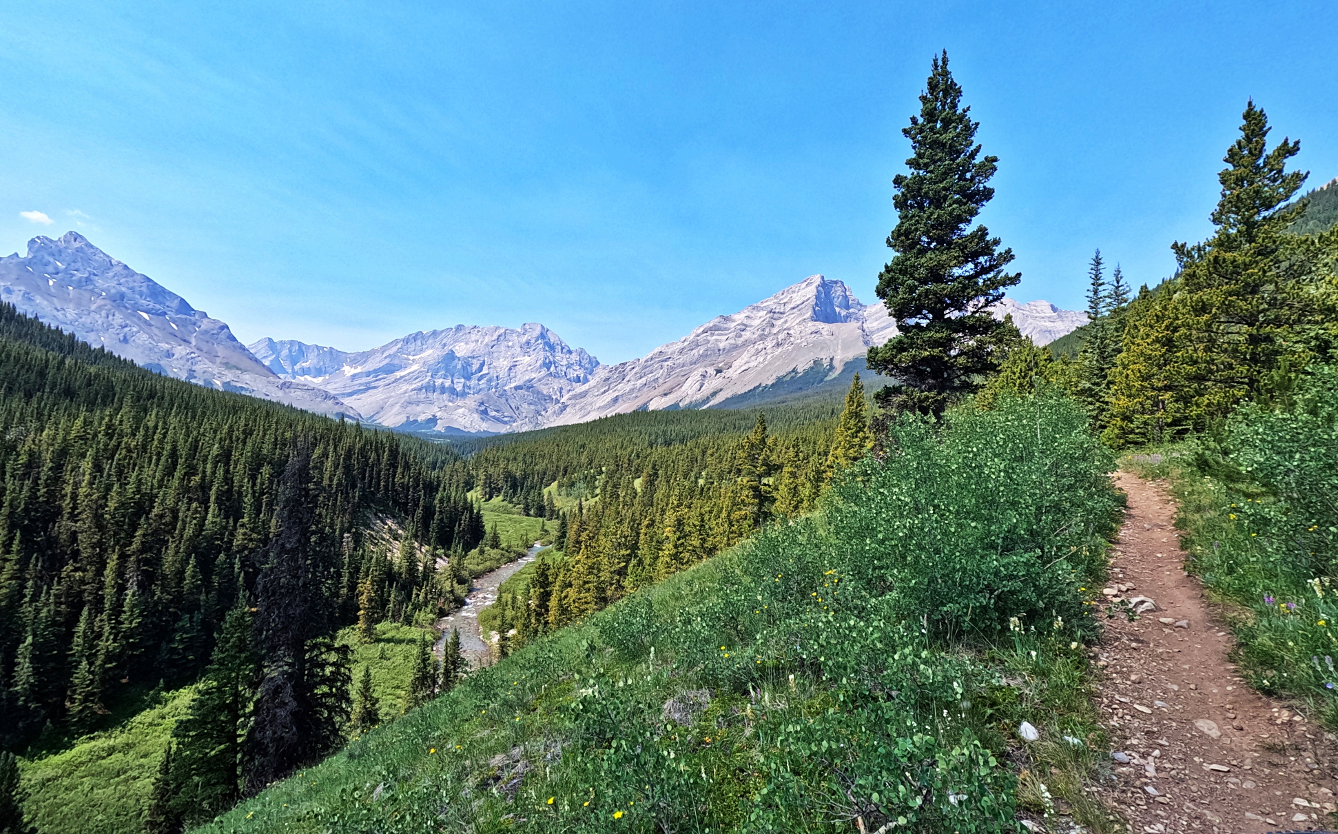
Moose Mountain Fire Lookout
Type – X-Country; Distance – 12.7 km; Elevation – 335 m; Time – 2-4 hours
This is a non-technical out and back x-country bike ride where the lookout awards you with 360° unimpeded views. Once you leave the parking lot there is a pretty steady climb up to the meadow ridge below the peak. It is a gravel fire road that is covered in loose shale and rocks, making the ride up tough at times.

From the ridge below, you can see the switchbacks that climb 367 m. They look daunting, but once you climb to the top, you’ll be happy you did. The views of the front ranges in Kananaskis Country are breathtaking. Coming down, you need to be cautious of loose rocks, but it’s quite manageable.


The first 1.2 km of the trail is also used to access Moose Mountain Packer’s Trail.
Access – The trailhead is at the top of Moose Mountain Road, which is located off Highway 66, just west of Paddy’s Flats Campground. There is a small parking lot at the trailhead. It is marked on the map above. You must have a Kananaskis Conservation Pass to park.
Note – There are also a ton of technical downhill trails on Moose and Prairie Mountains. You can find more information on this area here.
Powderface Creek – Prairie Creek Loop
Type – X-Country; Distance – 17.5 km; Elevation – 490 m; Time – 3–5 hours
This loop ride is tougher than you would think by looking at the elevation gain. Climbing up to the pass on Powderface Creek Trail is no easy feat, though. With steep inclines and a trail littered with both loose and solid rock, as well as tons of roots, it requires fitness and a lot of experience in bike navigation. Most people will push quite a lot, but a new trail is being built that should make this a much more enjoyable climb.
It can done in both directions, but CW seems to be favoured.

From the pass, the ride down is on a better trail. There are still a lot of roots, rocks and a couple of natural jumps, but it is not as loose as the ascent trail. It ends on Powderface Trail, a gravel road. Take the road for a quick 2.5 km, 270 m descent to reach the trailhead for Prairie Creek. This road is the main reason you don’t want to do it in reverse, because it would not be a pleasant climb.
From the gravel road you can see the bridge that takes you to Prairie Creek Trail. It is a very good trail and has a few climbs, but is mostly a descent route. The exit is ½ km or so from the Powderface parking lot.


Access – Park at the Powderface trailhead parking lot, just west of Elbow Falls on Hwy 66. It is marked on the map above. You must have a Kananaskis Conservation Pass to park.
Big Elbow – Little Elbow Loop
Type – X-County; Distance – 43.1 km; Elevation – 510 m; Time 5-6 hours; Note – Absolute elevation gain is 510 m, but with so many ups and downs most people say the elevation gain is between 900 and 1100 m.
This classic x-country bike route is a long day with a lot of elevation gain but offers sweeping mountain views at multiple spots. The ride is on a mix of old fire roads with a few washout sections and singletrack. It is generally in good condition and is not a technical ride.
You can do the route in either direction. We have done it both ways and are torn about which direction we prefer. Big Elbow has a lot of elevation gains and losses that are a lot nicer to do at the beginning of the ride than at the end. Many prefer the opposite direction so they can do the long, slow climb up Little Elbow. We’ll describe it in a CW direction beginning on Big Elbow Trail.
The trail begins by following the Elbow River upstream. Be prepared for a lot of climbing up and down the entire way, with a big final climb just before the pass. On the way, let the views of Mount Cougar, Elpoca and Three Point Mountains distract you from the grind.


Once you get to Little Elbow Pass the view of Tombstone Mountain is unbeatable and almost makes you forget about your fatigue. On the way back down Little Elbow Trail, you are treated to amazing views of Mount Romulus and Mount Remus.
Most of the descent (or climb) on Little Elbow is between Mount Romulus Campsite and the pass. It’s a gruelling 425 m climb if you go CCW.


Note – There may be hikers and horses on the trails.
Access – Park at the Little Elbow Recreation area on Highway 66. It is marked on the map above. You must have a Kananaskis Conservation Pass to park. Some older information online says you can park at the Little Elbow Campground, but parking is only allowed for those with a camping permit.
After biking these Bragg Creek trails, you can stop to see Elbow Falls. They’re not tall, but are quite pretty.

Pocaterra – Whiskey Jack Loop
Type – X-Country; Distance – 20 km; Elevation – 320 m; Time – 3-4 hours
If you include the Fire Lookout, add approximately 6 km, 280 m and 2 – 3 hours
The trail spends a lot of time in the trees, but from the Fire Lookout, you have unmatched views of Upper and Lower Kananaskis Lakes that make the ride worthwhile. Pocaterra begins by taking the x-country ski trails on a needle-covered fire road with constant ups and downs. Nothing too extreme but they seem endless. After 9.8 km, the trail intersects with Whisky Jack Trail. You can turn to follow this or continue straight to climb to fire lookout.
The route to the Fire Lookout is rougher, but you are treated to a spectacular view that includes Upper and Lower Kananaskis Lakes as well as Mt. Indefatigable. The view will make you glad you did this side trip.
The trip back down Whiskey Jack is a fast 4.5 km ride on a good trail. It gets even easier at the bottom by taking paved trails most of the way until you get to Upper Lakes Rd for the last 4 km back to your car.


You could also continue beyond the fire lookout to make it a longer loop.
Access – The Pocaterra Hut Parking Lot is off Kananaskis Lakes Trail, opposite the intersection with Smith Dorrien-Spray Lakes Trail. It is marked on the map above. You must have a Kananaskis Conservation Pass to park.
Jumping Pound Ridge Loop
Type – X-Country; Distance – 21.8 km; Elevation – 630 m; Time – 4–6 hours
Getting up to Jumping Pound Ridge is a tough climb, but you are more than rewarded with panoramic views of the surrounding mountains. The ride can be done in either direction and both will give you a fairly steep climb through the trees. There are plenty of roots, but it is mostly rideable. Once at the ridge, you can enjoy the long, relatively flat ride in full view of the surrounding peaks. You can also walk a short distance to a lookout that offers picture-perfect views toward Moose Mountain one way and Mount Bryant the other.


For a longer day you can combine it with Coxhill Ridge. If you do this, it would be nice to have two cars because the two trailheads are 17 km apart.

Access – You can begin at any of the three trailheads on Powderface Trail, depending on the length and direction you want. The two trailheads on the southside (Jumpingpound Summit Trail and Canyon Creek Trailhead) are approximately 4 km apart. Lusk Pass Trailhead is halfway to Coxhill Ridge trailhead. They are all marked on the map above. You must have a Kananaskis Conservation Pass to park.
Banff-Canmore

Goat Creek – Spray River -Rundle Riverside
Type – X-Country; Distance – 42.2 km; Elevation – 744m; Time – 3 – 4 hours
Going in a CW direction, the trail follows beside Goat Creek and then Spray River and returns along Bow River to end at the Canmore Nordic Centre. You can begin at any of the trailheads, but we prefer to begin near the Nordic centre. No matter where you start, you must climb the dusty Spray Lakes Road to the Goat Creek Trailhead. We prefer to have this climb at the beginning of the ride rather than the end.


From Goat Creek trailhead, the ride travels between Mt. Rundle and the Goat Range, along the edge of Goat Creek. After 9 km, the trail intersects with Spray River Fire Road. Both are relatively flat with a few small ups and downs. You get a few glimpses of the surrounding mountains but spend a lot of time in the trees. Spray River Fire Road ends on Golf Course Road near Banff Spring Golf Course.

To return to your car, bike on the paved Golf Course Road past the golf course to reach the Rundle Riverside Trailhead. This trail is relatively flat but is covered in roots, making it much more technical than it would be otherwise. The trail is known to be very muddy after rainfall, which would make it very unpleasant.
At the end of Rundle Riverside, continue through the Nordic Centre. You can come back here another day to sample a few of their trails. They have 100s of technical, singletrack trails surrounded by outstanding scenery.


Access – The Goat Creek Trailhead Parking Lot is on Spray Lakes Road just south of Goat Pond. If you’re doing the loop though, it’s recommended to park at the Canmore Nordic Centre. Beginning this route in Banff is also possible, but still do it in a CW direction. They are all marked on the map above. Depending on where you park, you may need a Kananaskis Conservation Pass or a Banff National Park Pass.
Star Wars – Return of the Jedi Loop
The 2.5 km loop trail in Banff is a great trail for such a short distance. It is well built with perfect berms, a few jumps and wooden features. The 1 km, 50 m downhill trail connects to the 1.5 km, Return of the Jedi. This allows you to get back uphill and do laps without getting in the way of other downhill riders. The trail is considered a challenging blue, but there are dirt trails that allow you to avoid the more difficult features.
Instead of taking Return of the Jedi back to the top, you could ride the flowy Hoodoo Trail for nice views. If you want more of a challenge, you could try the black run called Top Notch. It begins near the top of Star Wars.


Access – You can park near the top of Star Wars on Tunnel Mountain Drive. Otherwise there are parking lots at either end of Hoodoo Trail on Tunnel Mountain Drive. It is marked on the map above. A park pass is required for Banff National Park. You can buy it at the park gates.
- You can find detailed information as well as maps on TrailForks or AllTrails.
- Pedal assisted e-bikes are now allowed on trails in K-Country. Check their website before heading out because this rule may change.

To read more of our adventures in Canada, click here.
For hiking trails in the Calgary area go to the page Trek-Bike-Ski, or to find out what to do in Calgary this summer here.
Coming Next – How To Spend A Weekend In Tangier, Morocco
For pictures from other blogs go to Gallery at monkeystale.ca
To read about more of our adventures go to Destinations.
If you like what you read, please comment or share (with credit) using the links below.


We'd love to hear from you, please leave a comment.