
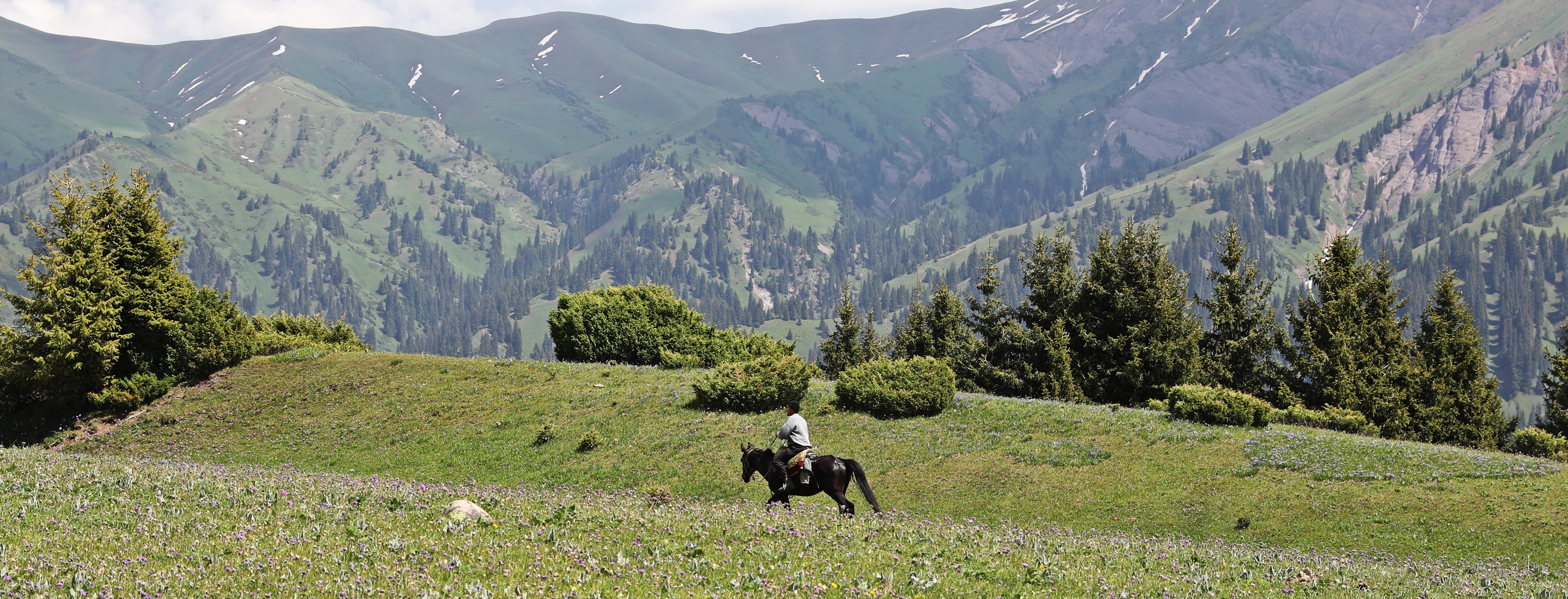
Long green valleys lead from the village of Jyrgalan to the picturesque, white-capped mountains of the Tian Shan Range. It is a beautiful part of Kyrgyzstan and there are a few days hikes that allow you to explore these mountain views further. We found it difficult to find good information about the hikes in this area so we decided to create this guide on the Best Day Hikes In Jyrgalan.
The village of Jyrgalan is very rustic and quaint. There used to be two mines in the valley that were established by the Soviets. Now only one small-scale coal mine is in operation. Today instead of miners, the village mostly consists of farmers raising sheep, goats, horses and cattle. Many go up to high alpine meadows, called jailoos, in the summer to let their livestock feed.
Note: it is also spelled Dzhergalan, and to make it worse, not far away is another village called Jergalan.


The elevation of Jyrgalan is 2,300 m, so the cool mountain air makes it a nice temperature to hike. We had read many glowing reports on-line about the hiking in the area. In all honesty, there aren’t as many day treks as we thought. At the moment it is geared more toward multi-day guided treks than it is for independent day trekkers. The hikes that do exist tend to either be on gravel roads or involve making your own way with only a general direction in mind rather than a trail.
Having said that, we were able to find a few treks that we can share with you. Here are our suggestions for Day Hikes In Jyrgalan.
Kok-Bel Waterfall
Distance – 6 km each way
Elevation Gain – 450 m (1,476 ft)
Trekking Time – 1 ½ hours one way
Kok-Bel is a small, but pretty waterfall that is quite easy to reach. There are two waterfalls of the same name on Maps.Me. Head for the one that is east of town.
When you leave the village, follow the road that goes by the small collection of homes on the east side of town. The road will pass by the old mine and then you can see green hilly fields filled with grazing horses and cows.

The road ends at the new mine. Follow the turnoff that goes to the mine offices, not the one that goes toward the mine shaft. From the offices, a vague trail crosses to the far side of the meadow. There are a few route marking red arrows on large rocks on the meadow. These continue for the entire trail.


From the far side of the meadow the trail travels up the small valley on the right and soon you will see Kok-Bel. It’s a small but pretty waterfall dropping off a 30 m high cliff. A number of large rocks at its base make a good spot to sit and enjoy the falls.
There are two more higher sections to the waterfall, but its very steep terrain and we didn’t attempt going higher. Return back to town the same way or climb up through the pastures to the ridge of Chaar Jon Panorama (below).

Chaar Jon Panorama & Turnaluu-Kol Lake
Distance – 10 km loop (6 ¼ miles)
Elevation Gain – 800 m (2,625 ft)
Time – 1 ½ hours
The tall, green hill immediately above the collection of homes on the east side of Jyrgalan is your objective for the hike. Follow the road past these houses and climb up the ridge with electrical poles. Once you reach the end of the electrical poles, continue to climb to the top of the next grassy peak. There isn’t a trail so find the best way that suits you. There will likely be horses, cows, sheep and goats grazing on the hill.
The higher we climbed, the better the views. We could see far down the neighbouring green valleys to the white peaks at their end.
(The hike is called Turnaluu Kol Panorama on Maps.Me)


We visited in mid June and the alpine wildflowers were in full bloom. Almost every hillside was covered in purple, yellow, orange and white wildflowers. Our favourites were the purple irises. (Iris ruthenica)


From the top you realize why the hike is called Panorama. You have a 360° view of the green hillsides and snow-capped mountains in the distance. When we were there, it was raining so our views were a little obscured by cloud.


You can either return the same way or follow the ridge that travels west. After you get a little lower you can see Turnaluu-Kol Lake surrounded by fir trees. It’s a very small lake, possibly only a pond, but makes for a nice end to the hike. From there follow the slopes back to your starting point on the east end of the village.

Jyrgalan & Terim Tor Valleys
Distance – 8+ km (5 miles)
Elevation Gain – 400+ m (1,300 ft)
Trekking time – 2 ½ hours
The long, wide Jyrgalan Valley is edged by green hills that lead to snowy peaks at its end. It is a very picturesque place to spend your day. The trail that travels up Jyrgalan Valley leaves outside of town. Begin by crossing the river on the gravel road. Then find the faint trail that follows beside the river. The route climbs up and down a few small hills on the bottom of Chunkur Tor as it makes its way up the valley.
The first destination is Eki Chat Yurt Camp. A trail to it is on Maps.Me, but you may want to use it as a general guide rather than an absolute route. Richard said the Maps.Me trail looked as if someone attached a GPS to a cow and posted the wandering trail that the cow took. The rambling trail crosses a few small creeks before eventually joining a gravel road.


The trail traverses along the entire base of Chunkur Tor Mountain and once at the end, another valley comes in from the west. The yurt camp is located on the other side of the intersection of Jyrgalan and Terim Tor Valleys. It is a nomad’s camp and their horses, cows, sheep and goats can be seen grazing along the route. You can continue walking further up Jyrgalan Valley if you like and return back the same way.

We had initially intended to go up Robbers Canyon, but it involved crossing the Jyrgalan River, which in mid June was a wide, fast-moving river. The reports we had read said to cross the creek, so maybe in the fall the river is lower and it is possible to cross. Robbers Canyon is the valley on the left side in the picture above.
Instead of going east to Robbers Canyon, we turned west and walked up Terim Tor Valley toward the pass. It’s an easy walk up to the pass with a slow gain in elevation. From the pass we were surprised by yet another beautiful view of snow-capped mountains. You can follow this valley for a while too if you like, but there didn’t appear to be a trail.

We wanted to get a view from a little higher so we hiked up one of the gullies on Chunkur Tor. It turned out to be a very steep slope that was covered in small shrubs and large rocks. It is not a route recommended for inexperienced hikers. It did however, offer great views of the mountain ranges.


Near the top of the mountain we decided to traverse it by trekking just under the summit ridge. Unfortunately, it has numerous undulations as you cross over gullies and rock bands, many with small cliffs to navigate. Near the end of the route we had 4 or 5 boulder fields to cross.
The hike ends with a steep descent to the meadow that holds Tulpar Tash (see below). This part of the hike is a major undertaking without a trail and on very rough terrain so is not recommended for most hikers. It took us almost 3 hours to hike up, across and down the mountain.


Tulpar Tash
Distance – Approx. 3-4 km (1.8-2 ½ miles)
Elevation Gain – Approx. 200 m (650 ft)
Time – 1 hour
The large boulder called Tulpar Tash, has a connection to beloved character Manas. He is the protagonist from an epic poem about the Kyrgyz people’s fight for independence. It was written in the 1800s but the story takes place in the 1200s. The legend says that Manas’ horse was so strong, it ran up to the top of Tulpar Tash and jumped off it, leaving his footprints in the rock.
It’s quite easy to reach the rock from town. Begin as you would to go up Jyrgalan Valley by crossing the river on the bridge right outside of town. Not long after the bridge you can see a trail on your right that climbs up the hill. Follow it until you reach a large meadow near an electrical tower (pylon). Continue walking on the trail toward Chunkur Tor Mountain and soon you will reach a large boulder. There are no signs or indications that you’ve reached the right one, but on the opposite side of the boulder you can see indentations in the rock. They do look an awful lot like horse’s footprints, so maybe the tale is true.

From the rock it would be possible to hike up to Chunkur Tor Lake by following the first creek coming down from the mountain. When we were on Chaar Jon Panorama the day before we could see that this area was still snow covered, so likely the lake was still frozen.
Getting to Jyrgalan
Located 62 km from the city of Karakol, the drive takes an hour and a half. It you don’t have a car, marshrutka #331 leaves from the Big Bazaar (Ak Tlek Market) at 8:30 am, 1:30 pm and 4:30 pm and takes 2 hours. The cost is 110 KGS ($1.25 USD) plus 50 KGS (58 cents USD) for each piece of luggage. The signs on the marshrutka say ‘ШАХТА’ (pronounced Shakta), and ‘Jyrgalan Village’. Marshrutkas return to Karakol at 7:30 am and 11:30 am.
The drive from Karakol to Jyrgalan is lovely passing through pastoral lands that lie below lush, green hills. There are several good day trips from Karakol so consider staying there for a few days on your way to or from Jyrgalan. You can read about what to do in Karakol here.
Where to stay and eat in Jyrgalan
Don’t expect luxurious accommodations in Jyrgalan. The only accommodations are homestays and most have shared bathrooms. But they are very clean and the people who run them are incredibly kind and friendly. There are no restaurants in the village. Delicious homecooked meals will be provided by your homestay. Let them know the day before arriving if you have any special dietary requests. They are very willing and able to accommodate.
When to visit Jyrgalan
Like many mountain destinations the hiking season in Jyrgalan is quite short. It usually runs from mid June until mid September. If you go too early or too late you’re likely to encounter snow at higher elevations. We visited in mid June and there was still quite a lot of snow on the high passes. As well, it rained for 2 of our 3 days.


For Travel Tips in Kyrgyzstan go to our post on Fergana Valley.
To read more stories from Kyrgyzstan click here.
Coming Next – A Yurt Stay in Song Kul, Kyrgyzstan
For pictures from other blogs go to Gallery at monkeystale.ca
To read about more of our adventures go to Destinations.
If you like what you read, please comment or share (with credit) using the links below.


We'd love to hear from you, please leave a comment.