
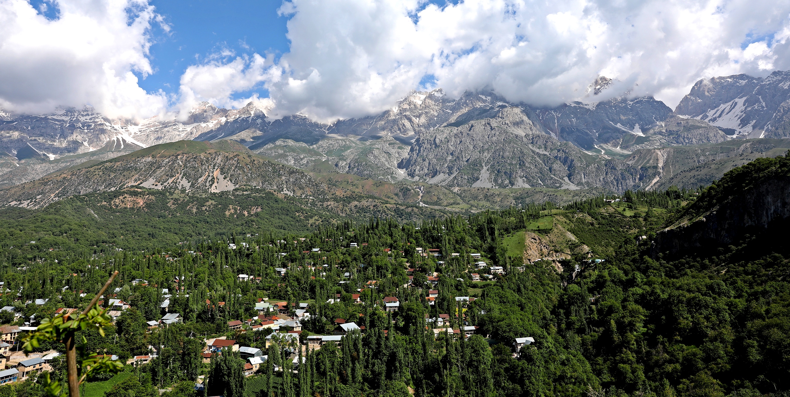
After visiting the Fergana Valley in Uzbekistan, we wanted to see Kyrgyzstan’s version of this divided land. We had expected them to be quite similar, but what we found was the opposite. Kyrgyzstan’s Fergana Valley is much more mountainous and rugged than the gardens and farms of Uzbekistan. It seemed like it would be perfect for mountain lovers.
Go Directly to Travel Tips for Kyrgyzstan here.
Fergana Valley has been known as a fertile garden in arid Central Asia since the days of the Silk Road. The name is a bit misleading as it is not a valley at all, but rather a depression between the tall Tian Shan Mountains in the north and the Alay Mountains in the south. Historically it was ruled by as many different Khans as the rest of Central Asia. When the borders were created by the Soviets in 1917, they were done in a haphazard manor dividing the valley between Uzbekistan, Kyrgyzstan and Tajikistan. At that time the borders didn’t really affect the people because they could come and go as they pleased. When the countries gained independence however, the borders and the wealth that was contained in the land, mattered a lot more.
Looking at the map below, you can see how willy-nilly the borders are. The cities we visited in the three countries, Kokand in Uzbekistan, Khujand in Tajikistan and Osh in Kyrgyzstan, used to be one region but now are separated by an arbitrary border.

A large part of the problem is that the people’s ethnicities do not follow these arbitrary lines. Families found themselves suddenly living on opposite sides of the borders from each other. Jealousy and hatred developed between people who were once family and neighbours because of the feeling of inequity in the distribution of land. Many say that this was done to ensure that there were minorities in each Soviet state. This population diversity would create internal fighting and keep the heat off the Soviet rulers.
In Kyrgyzstan, most of the land south of the Tian Shan mountains is called Fergana Valley. The people who live in Kyrgyzstan’s Fergana Valley are mostly ethnic Uzbek rather than Kyrgyz. It’s almost as if the south is a separate country from northern Kyrgyzstan.
Uzbekistan to Kyrgyzstan Border Crossing
After visiting the Fergana Valley in Uzbekistan, we made our way to Kyrgyzstan. Getting to the border from Margilan to Dostyk, Uzbekistan by a taxi was quite easy. Once we arrived, the line up on the Uzbek side was short and it all seemed to go very smoothly. That is until we reached the Kyrgyz side. We arrived at a fenced-in sidewalk that was crammed full with a long, disorganized crowd of people waiting to cross.
We had heard there was a VIP line that foreigners could use but we couldn’t see it, so we joined the long line. Calling it a line is misleading though. If the sidewalk could fit four abreast, this line up had six. Soon we were in the middle of it with large backpacks on our backs. At the end of the sidewalk was a set of doors that led to the border agents. The doors only opened every 20 minutes or so to let in the next 30 people in line. Each time the doors opened our line would push and shove toward it.
The temperature was rising, the sun was strong and there was no where to move or even breathe. Finally, an hour and a half later we reached within striking distance of the doors and the next time they opened we made sure we were able to get inside. Of course once we got inside we found another long line up. A lady who we met outside tried to tell us that as foreigners we could go to the front of the line. Just as she said that though, a Kyrgyz family was trying to cut in to the front of the line and a huge argument ensued. We stayed put in the middle of the line.
Canadians don’t need a visa to enter Kyrgyzstan, but many countries do. The customs officer was having a difficult time determining if he could let us through, but finally he gave us our stamps and we were on our way to Osh.
Osh
The largest city in Kyrgyzstan’s Fergana Valley is Osh and is the first city you will stop at if you travel from Uzbekistan. It is also the main access point to explore some of the country’s mountains. Osh used to be the starting point of Pamir Highway tours, but the Kyrgyzstan-Tajikistan border closure has put an end to the Kyrgyzstan section of the great road trip.
Osh doesn’t have a lot of sites for visitors, but we were able to find a few things to fill our day.
Sulaiman-Too
Osh’s location in the Fergana Valley means that it has a long history as an important place on the ancient Silk Road. A notable monument that can be seen from many parts of town is Sulaiman-Too (Solomon’s Throne). This 200 m limestone outcrop used to be a route marker on the Silk Road and demarcated the halfway point from China to Europe.
At its base is the 16th century Ravat Abdullakhan Mosque.


A walking path allows you to climb to the top of Sulaiman-Too. On the way you pass terraces that were used as early as the Bronze Age. Not far away are petroglyphs that were made by the same people. Unfortunately, most of the petroglyphs have been vandalized. It was quite upsetting to see, but we did find a few that were untouched.


Above the terraces you can’t miss the eye-sore sticking out from the mountain wall. It is the entrance to the Soviet built museum that takes over one of the mountain’s caves. Inside are a few Bronze Age artifacts that were found on the mountain. The museum was quite disappointing as it has very few pieces on display. As well, it looks very artificial inside instead of looking like an authentic, cave even though it is. We don’t recommend visiting the museum.


There are many other caves on the mountain that have been left in their natural state. One of them is used by locals to pray.


The mountain is called Sulaiman-Too because of the legends that connect it to the Prophet Solomon. Some legends say he prayed on the mountain; others say he is buried on the mountain. Another version says that the imprint of Solomon’s knees and fingers can be seen at the summit, but we couldn’t find them.
What we did find near the mountain’s top is Babur’s House. Babur was a grandson of Uzbekistan hero Amir Temur whose buildings we explored in Samarkand and Shakhrisabz. Babur became infamous on his own as the first leader of the Mughal Empire in India. Babur’s House is a small mosque that he had built to meditate on the mountain top. The original building was built in the 1400s, but the current one is from the 1990s.


Entrance to Sulaimon-Too – 20 KGS (25cents USD)
Foreigners’ Entrance to museum – 150 KGS ($1.75 USD)
Jayma Bazaar
Another remnant from the Silk Road is Jayma Bazaar. Operating for more than 2,000 years, it is one of the oldest markets in Central Asia. Although it didn’t seem to have any Silk Road artifacts left, we found hundreds of stalls selling just about everything you could imagine. Our favourites are always the vendors who sell spices, nuts and fruits. We were there during apricot season so purchased a half kilo of juicy apricots for pennies.


While walking to the market we started to get a sense that even though the people are more ethnically Uzbek, they have a strong Kyrgyz identity. The first difference we saw were the hats that Kyrgyz men wear throughout the country. We saw the tall white and black felt hats for the first time in Osh, but continued to see them on our travels in Kyrgyzstan. Near the market we also passed a group of women in traditional dress who were celebrating something, but we’re not sure what.


Soviet Mosaics
As with the rest of Central Asia, Soviets ruled Kyrgyzstan beginning in 1917. It gained independence in 1991, but there are still quite a few remainders in town from this part of its history. Unlike most other Central Asian countries, Kyrgyzstan seems reluctant to take many of these down. First we found Lenin’s Statue still standing proudly opposite City Hall.

As we walked further we found old Soviet mosaics on the sides of a few Soviet buildings. They are recognizable by their common themes of solidarity and worker’s paradise. The strange thing is that these murals have neither been removed or damaged.


Getting to Osh
Osh has an airport, but flying to it from Bishkek will mean you will miss half of the country’s landscape. Located in the southern part of Kyrgyzstan, Osh is a little trickier to reach from the north by road but it does go through a gorgeous part of Kyrgyzstan’s mountains. The highway crosses over two high mountain passes in the Tian Shan Mountains, Tor-Ashu and Ala-Bel Passes. Minibuses are not allowed to travel this route so the only option is to rent a car and drive, or take a share-taxi.
If you’re coming from the south, Osh is very close to the border with Uzbekistan and can be easily reached by minibus from Tashkent. If you’re in the Uzbek Fergana Valley, you can take a taxi to Dostyk and then walk across the border and take a taxi on the other side. There are no ATMs at the border, but there are several money exchanges. If you’re going the opposite way, the town on the Kyrgyzstan side is Dostuk.
Osh used to be the beginning or end of Pamir Highway trips but as of 2022 the border between Kyrgyzstan and Tajikistan was closed and is not expected to open anytime soon.
Arslanbob
We had read romantic tales of a charming mountain town set below the world’s largest walnut forest and surrounded by gorgeous mountains. All of this is actually true, but the reality of Arslanbob is not the pristine mountain town we had read about on-line.
The town has a gorgeous location below the majestic Babash-Ata Mountains in the Tian Shan Range. The mountain views are spectacular. The town however is quite rough around the edges. Homes are shabby, and the main square is a hectic place with no character.
The mountains, although beautiful are quite inaccessible. As we found with much of Kyrgyzstan there are not many hiking trails that allow you to delve further into their rugged mountains.


Hiking in Arslanbob
We had already committed ourselves to two nights in the town so instead of complaining, we decided to make the best of it. We found a few hikes that are within walking distance from town. Each of these hikes could be done on their own, but by cutting through the walnut forest we were able to make it into a circuit route and did all of them in one day.
Panorama Hill
About 200 m above town is a nice lookout on Panorama Hill. From the viewpoint we could see the gorgeous cirque of the Babash-Ata mountains behind the town as well as interesting rock features on the nearby cliff.
The trail to the viewpoint is a gravel road that begins on the edge of town near the river. The route is on Maps.Me.


If you continue to walk above the viewpoint you’ll reach a large plateau that is a favourite picnic spot for locals. One thing we learned while in this country is that Kyrgyz people love picnics. There are many tapchans (daybeds) and most were already full at 10 am. They must also really love swings, because there were several and a few are very tall.


The plateau and surrounding hills are home to the world’s largest wild walnut forest (60,000 hectares). Once we left the picnic area we found ourselves in the middle of these magnificent trees; some are said to be 1,000 years old. A legend says that Alexander the Great travelled through the forest and enjoyed the walnuts so much that he took some back to Greece with him. To this day some countries, including Russia call walnuts, Greek Nuts.
The trees had already started producing nuts, but it was only June and they wouldn’t be ripe until the fall. Apparently the autumn harvest season is a great time to visit Arslanbob. At this time the entire village moves into the walnut forest to collect the nuts. They are known to go for 2 weeks at a time, sleeping in tents as their ancestors have been doing for hundreds of years.


Little and Big Waterfalls
The other two things to do are hike to the waterfalls. Big Waterfall is 7 km from town. You can drive almost right to it or follow Maps.Me and walk on the road, passing through a few small villages as you climb up and down the hills. It is a tall skinny waterfall with an 80 m tall drop off a cliff into a hidden pool. It was nice, but not the big draw that we had expected.


Not far from town is Small Waterfall. It’s only 30m tall but is much prettier than Big Waterfall. We visited on a Saturday when the town market lines the sidewalk leading to it.
You can reach Small Waterfall from a trail near the beginning of the Panorama Hill road or you can walk through town. The routes can be found on Maps.Me.


Getting to Arslanbob
Like many mountain towns in Kyrgyzstan, Arslanbob is not incredibly easy to reach. There is a direct marshrutka that leaves from Osh’s New Bus Station around 1:30 or 2 pm. It’s a 5 hour drive so if you want to leave earlier you can take a marshrutka to Jalalabad (180 KGS /$2USD, 2 ½ hours), then another to Bazar Korgon (50 KGS/57 cents USD, 30 minutes), and then a final one to Arslanbob (80 KGS/ 90 cents USD, 2 hours). We took these three minibuses and didn’t wait more than 5 minutes at each station to get our next one. It may sound confusing, but it was actually quite easy.
Where to stay
Accommodations in Arslanbob are very basic. Some can be found on-line and others are managed locally by CBT (Community Based Tourism). If you ask anyone in the main square they will know how to reach CBT and someone will come to meet you and help you find accommodation. Do not expect anything charming or luxurious, these are basic rooms in local homes. There are no restaurants in Arslanbob, you will buy your meals from your guesthouse.
Travel Tips for Kyrgyzstan
When we visit a new country we like to travel throughout it so can learn about the culture and people in addition to seeing the sites. In Kyrgyzstan it seems that they’re not quite ready for independent travel. There are beautiful mountains everywhere but they are difficult to access with very few hiking trails. There are small communities in fantastic locations, but they have no amenities for travellers and a very basic infrastructure. As well they’re often difficult to reach. It seems that the best way to enjoy what Kyrgyzstan has to offer is by taking multi-day treks, horseback rides or tours. Karakol, Jyrgalan and Song Kul seem to be the only areas that are really ready for tourists.
SIM Card – We purchased a Megacell SIM Card and 40GB of data for 490 KGS ($5.60). We went to a Megacell store and it was a very easy buy and install. Megacell coverage was quite good throughout the country. Note that not all plans allow hotspot.
ATMs – We were able to get money out of almost every ATM. The most important thing to be aware of is that they only accept 4 digit PINs. Most had no fees and the amount we were allowed to withdraw depended on the bank and the city. Withdrawal limits seemed to range from 5,000-20,000 KGS but average was 12,000 KGS.
Getting Around Kyrgyzstan – There are not many inter-city buses and no passenger trains in Kyrgyzstan. Some travellers rent their own vehicle, but we met people who had mechanical problems and had a lot of hassles with their rental agency. You can also hire a private driver. The most common mode of transportation are Marshrutkas. This is our preferred way to travel, partly because it’s much cheaper, but also because we get to meet a lot of the locals. They travel almost everywhere in Kyrgyzstan, but not often for long distances. Sometimes you have to hopscotch your way from town to town on different marshrutkas to get to a far away destination. It is also quite easy and safe to hitchhike. We did it quite a few times for short distances (1- or 2-hour drive). But have heard of other travellers hitchhiking over much longer distances. When hitchhiking remember that most drivers expect a small payment, usually less than a marshrutka.
Ride Share – Yandex is the rideshare app used in Bishkek and Osh. It works seamlessly but it is not available in the rest of the country.
Language – The people speak Kyrgyz and Russian and they use the Russian alphabet for both. Almost all signs are only written with the Russian alphabet so it can be very difficult to read anything including signs on buses, shops, restaurants and menus. Google Lens helps a lot to read a menu, but not signs. It would help if you have a screenshot or picture of the town name, hotel etc that you are trying to get to. Many people cannot read the names of cities written in the Roman alphabet.
When to travel to Kyrgyzstan – June to September are best months if you want to spend time in the mountains. Summer is very hot at lower altitudes, but cooler in the mountains. Winter is cold (-20C) and roads can be in poor condition. If you travel in May or October there may be too much snow at higher elevations.
Safety – Kyrgyzstan is a very safe country for tourists. We walked everywhere when visiting Kyrgyzstan and never felt unsafe. The only potential dangerous areas are the land border crossings so make sure to research the current situation before crossing.
Visa – Citizens from many countries are able to get a visa on arrival. Others need to apply for a tourist visa in advance, so research the policies for your citizenship.
What to wear – Kyrgyzstan is generally a conservative country when it comes to women’s attire. In most cities and towns, local women wear short sleeve tops (never sleeveless) and long pants or skirts. Bishkek is the outlier where younger women wear knee length skirts or even shorts. Tourists should also wear conservative clothes. I wore short sleeves with long pants or skirts and felt quite comfortable.
To read more of our stories from Kyrgyzstan click here.
Coming Next – A Taxi Ride With A Kyrgyz Man
For pictures from other blogs go to Gallery at monkeystale.ca
To read about more of our adventures go to Destinations.
If you like what you read, please comment or share (with credit) using the links below.


We'd love to hear from you, please leave a comment.