
Hidden between the limestone-covered hills in northern Jordan is the Gadara Archaeological Site. As one of the Roman Empire’s 10 Decapolis cities in the Levant, Gadara held a prestigious position. Today, it is mostly in ruins, but walking along its ancient streets brings Gadara’s history to life. Not far away are the vestiges of Pella, another Decapolis city. Their location near the city of Irbid allows you to spend a day visiting the historical attractions in all three.
To see where Irbid, Gadara and Pella are located, please click on the link to view our interactive map of Jordan.
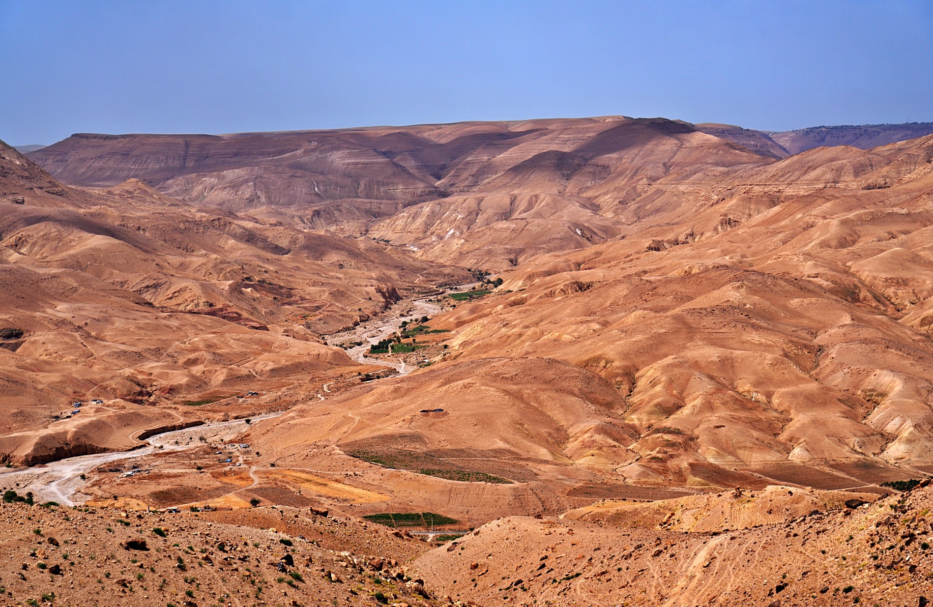
As we drove through the hills from the city of Irbid to Umm Qais, we couldn’t stop staring at the landscape. The limestone-covered hills all around reminded us of the Canadian Shield back home. What let us know we were in Jordan were the olive, Algerian oak and eucalyptus trees growing in every available crack. What surprised us was that their roots could find enough soil between the stones to support such large trees.


Umm Qais Archeological Site
Now located in the Jordanian city of Umm Qais (Qays), the ancient city of Gadara was first settled by Alexander the Great in the 3rd century BCE. It was initially built as a military post to guard the edge of the Ptolemaic Dynasty’s land. It changed hands and was under the Hellenistic Seleucids before the Romans captured the military post and transformed Gadara into a large city. Located on the Palestine-Syria trade route, the city quickly gained wealth and importance, eventually becoming one of the Roman Empire’s Decapolis cities. This league of cities were semi-autonomous and worked together to bring prosperity and safety for the group. Other Decapolis cities in Jordan are: Philadelphia (Amman), Jerash and Pella.
On our visit, we could still appreciate its placement on this ancient trading route. From the archaeological site, we looked out to see the Sea of Galilee (Lake Tiberias) in Israel and the Israeli-Occupied Golan Heights in Syria.
You can read about Philadelphia in our post from Amman, and Jerash here.

When you enter the museum, you will first see the 19th century Ottoman village built atop the Roman ruins. It still takes up much of the hilltop, and you need to walk through it before reaching the Roman city of Gadara.

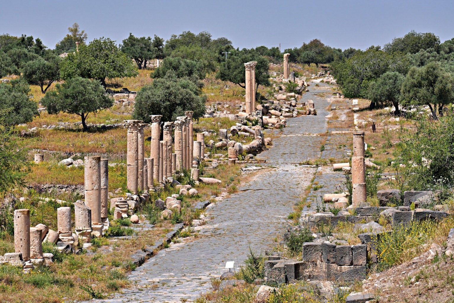
As they did in many of their cities, the Romans built roads, paved them with stones and covered them with colonnaded arcades. Decumanus Maximus was the main street in Gadara, and it stretched more than 1.5 km along the ridge. Markets and houses once lined the sides, but today not much of that scene remains. Instead, broken columns lie in the space where shops once stood.
You can see an interesting construction detail in the basalt paving stones. If you look closely, you’ll notice they were laid at a 45-degree angle. This was done to prevent cart wheels from getting stuck between the stone slabs.


Although we can’t see many of them anymore, many side roads branched off from this road. Unfortunately, in 749 AD, the Galilee Earthquake flattened Umm Qais, so most of it is in ruins. This massive earthquake also destroyed both Pella and Jerash. We’ll take you to Jerash soon.
Even though it is in ruins, you can still appreciate many details from the old city. For one, you’ll find an interesting variety of columns. They don’t have a uniform look in either their style or materials. Some columns are made of basalt, others of limestone, or a compressed sedimentary rock called caliche; a select few are even made of marble. As well, their capitals are a mix of Ionic and Corinthian. We even saw a few uncommon Byzantine columns with support corbels at the mid-shaft. Together, these create an eclectic mix we may not have noticed if more buildings were standing.


Poppies and thistles growing in the cracks underfoot give it a wild look and show that it doesn’t receive many visitors. We saw several budding and flowering artichoke thistles; many were covered in the colourfully striped Bumble Bee Scarab Beetles.


Due to the desert location, water was a concern. Although the average annual rainfall of less than 500 mm (22 in) doesn’t sound bad, none of it falls in the summer. Holding and transferring freshwater therefore took clever engineering. To solve this problem, the Romans built an extensive aqueduct with water pipes travelling in underground tunnels.
These pipes didn’t just deliver water through the city; underground tunnels connected them to other Decapolis cities. In fact, the Romans built a total of 170 km (105 mi) of rock-cut tunnels between 90 and 210 AD. There’s no doubt, then, why this system is considered one of the most significant hydro-engineering projects in the ancient world.

After the Roman Empire ended, the Byzantines took over Gadara and transformed former Roman temples into churches. We saw a little evidence of that along the main road, but the biggest site is hidden on the edge of the town. Behind Tiberius Gate are the remains of a 6th century Byzantine basilica built on top of a Roman mausoleum. We could see the subterranean necropolis from above and were curious, so we slowly crept down the stairs to see it up close. It turned out to be one of the best finds in the entire site. We peered from the door to see its four walls inlaid with crypts, under a stone roof.
A vague museum sign points to the crypts, but unless you go right to it, you would never know what is hiding below the surface.


At either end of the city are the East and West Theatres. We first saw the basalt stones of the West Theatre from the other side of a gorge. Although the stage is in almost complete ruin, the seating for 3,000 spectators still stands. The East Theatre, though, is covered in grass and earth.


Other buildings included fountains, baths, and hippodromes, but sadly, not much is recognizable.


Sea of Galilee
After exploring the archaeological site, our driver took us to a viewpoint of the Sea of Galilee. There was a lot of dust in the air, but we still enjoyed getting a closer look at this famous body of water.


Even though it is mostly in ruins and the signage is quite poor, seeing the size of Gadara, the views of the Sea of Galilee, and the Roman mausoleum made the day worthwhile.
Umm Qais is on the UNESCO tentative list.
Entry – is on the Jordan Pass, otherwise is 5 JP ($7 USD); Opening Hours 8 am to 7 pm, daily (closes at 4pm in winter).
Getting to Umm Qais
You can reach Umm Qais by local minibus from Irbid, but you would still need to hire a taxi to reach the archaeological museum. Although it is possible to visit it on a day tour from Amman or Jerash, we chose to stay in the city of Irbid, which is much closer.
We hired a taxi driver in Irbid to take us to the site, wait, and return to the city for 30 JD ($42 USD). Even though he only knew a few English words, and we knew the same amount in Arabic, we still had a great day with our driver. He invited us to his house for dinner the next day, but unfortunately, we were already on our way out of the city. This was another example of the welcoming reception we experienced in Jordan.
Archaeological Site of Pella
While not in nearly as good condition as Gadara, Pella was also a Decapolis city during the same era. The settlement was mentioned much earlier, though. In ancient Egyptian texts it was called Pihilum or Pehelin, and in the Bible it was known as Peniel. When the Hellenistic Ptolemaic Dynasty built a town on these hills, they named it Pella.
In 63 BCE, Roman Emperor Pompey conquered the city, and under the Romans, Pella flourished. Like Gadara, its location put it on ancient trade routes, and Pella soon became a wealthy city. Its prosperity continued under the Byzantines, who erected churches over Roman Temples.


Unfortunately, the same earthquake that destroyed Gadara also flattened Pella. What was once a large settlement is now only a collection of columns scattered across the hills, and there really isn’t much left of this once important Decapolis city.


One of the best parts of visiting, is seeing the beautful landscape where arid hills drop into green olive orchards.


Entry Fee – it is included on the Jordan Pass, otherwise entry is 2 JD ($2.80 USD); Opening hours 8 am-5 pm.
Getting to Pella
It is not possible to reach it by public transit, and we did not see it offered on tours, so you will need to have your own car or driver to visit. Located near the city of Tabqet Fahel, Pella is 44 km (27 mi) from both Irbid and Jerash, and 80 km (50 mi) from Amman. This makes it easy to visit Pella on a day trip from any of these cities. We visited from Jerash and combined it with Aljoun Castle, so the trip to this small site still felt worthwhile.
Irbid
Not far from Umm Qais is Jordan’s second-largest city, Irbid. Today, it is known as a university city, but its roots go back much further. Irbid was settled as early as the Bronze Age, but it grew under the Romans because it was situated between the Decapolis cities of Gadara (Umm Qais) and Pella. Its location near the Umayyad capital, Damascus, meant the city came into even greater prominence under the Ottoman Empire.
Today, the city looks like a less polished version of Amman. Its limestone buildings are a little more worn, and there is more litter on the streets, but it is still a nice, friendly city. Spread across several hills, the city has an interesting look.


There are not a ton of things to see in Irbid, but we found a few things to fill a half-day.
Museum of Jordanian Heritage in Yarmouk University
Housed inside the University of Yarmouk’s Faculty of Archaeology is a surprisingly good museum. It’s not a large space, but you’ll find a wide variety of artifacts found in the region dating from the Stone Age to the Islamic Caliphate. These include 250,000-year-old flint tools, sarcophagi from Gadara and Umayyad pottery.

We’ve seen these lime-plaster statues from Ain Ghazal in other museums, but the Neolithic statues never fail to impress. The museum also has 2nd millennium BCE clay burial jars with skeletons still inside.


Entry is free; Opening Hours – 10 am-1:45 pm and 3 pm – 4.30 pm, Sundays to Thursdays. Closed Friday and Saturday. You need to show your passport at the entrance to the university grounds.
Dar As-Saraya
Built in 1886, Dar As-Saraya was an Ottoman caravanserai that provided a refuge for travellers on the Levantine Hajj pilgrimage route to Mecca. After the Ottoman Empire fell, the old building was used as a prison until 1994. One of the best parts of visiting the museum is seeing the wonderful basalt rock walls from the old inn.


The other reason to visit is to see artifacts from as long ago as the Stone Age. There were Roman busts used on grave markers and cinerary urns from Gadara, Byzantine mosaics and an old basalt door.


Entry fee – is included on the Jordan Pass, otherwise it is 2 JD ($2.80 USD); Opening Hours – 8am to 7pm, in winter it closes at 4pm. You need to show a paper copy of your Jordan Pass.
Cultural House of Arar
This small museum is located in the former home of Jordanian poet Mustafa Wahbi al-Tal. His pen name was Arar, so it is also called Beit Arar (Arar’s House). It displays a few of the writer’s personal possessions and photographs. In addition to being the writer’s home, the building served many uses over the years, including a school, a medical clinic and today, a cultural events centre.
The single-story house only has a few rooms, and all have doors that open up to a tree-filled courtyard. This was typical in Damascus, Syria, in the 1800s. Several homes in Irbid were built in this style since there was a strong cultural and trade connection between the two cities.
Between Arar House and Dar As-Saraya, a mosque and a church sit side by side on the street, a scene we often saw in northern Jordan.


Entry is free; Opening Hours – 8 am to 3 pm, closed Friday and Saturday.
Tip – When we visited Jordan, our GPS was often not accurate. The cause was jamming due to the Iran and Palestine wars. This was especially true in Irbid, Umm Qais and Pella.
Where to stay and eat in Irbid
The city is not used to a lot of international tourists, but you can find a few hotels and restaurants near Yarmouk University.
Tip – There is not as much English in Irbid, so having your destination written in Arabic makes it easier with taxis.
How to get to Irbid
There is an airport in Irbid, but most visitors arrive by road: either self-drive, taxi or bus. If you rent a car, the highway is very good, but remember that you many not have accurate GPS. If you take a bus from Amman, Jett Buses leave from their office near Circle Seven in Amman, and in Irbid, they use their office near Amman Station. They are comfortable, affordable, and operate on time.
Please note, we visited Jordan in the spring of 2026. At that time, there was a ceasefire in the Iran War due to the signing of the Memorandum of Understanding. Since conditions are changing frequently, please read current news on the area before planning your trip.

Here’s a link where you can read more of our adventures in Jordan, and a link to our interactive map of Jordan.
Coming Next – Jerash: Explore the Roman Decapolis City
For pictures from other blogs go to Gallery at monkeystale.ca.
To read about more of our adventures go to Destinations.
If you like what you read, please comment or share (with credit) using the links below.




We’d love to hear from you, please leave a comment.