
This is an incredibly beautiful trek through the arid, deep valleys and high passes of the colourful Markha Valley. There are many old Buddhist monasteries, chortens, and mani walls that add to the area’s mystique.

The following information is based on our experiences on the Markha Valley Trek in Ladakh. It is not intended to be a guide, but hopefully will provide extra helpful information.
- We included our trekking times. Note that times do not include breaks, we were acclimatized and carried our own full packs.
- We trekked in July 2018.
- We did not use a guide, and one is not necessary. We stayed in homestays of which there are plenty. You’ll find at least 2 homestays even in the smallest villages. Many villages are organized on a rotation system, so you don’t get to choose your stay. Costs are 1200 Rs per person per night and include a bed, tea on arrival, dinner, breakfast and a bag lunch. After Jingchen they have filtered water available at no cost. They all provide blankets and pillows, so you don’t have to bring a sleeping bag, but we brought our own. Not all of the homestays are as clean as we wanted. They are very basic with thin mats or rugs on the floor and a Tibetan style table for tea/meals.
- You can camp at any of the towns and at most homestays. You can get meals at the homestays if you’re camping.
- We did the trek in 6 nights, 7 days, but we added a side trip to Stok La, and were not able to find a ride to the start of the trek. We also had one very long day that most would break into 2. It could be done in 5 nights/6 days or pushed to 4 nights if you’re acclimatized. It can also be started from Chiling to make it shorter, or from Stok to make it longer.
- We took a public bus from Leh to Spitok to visit the Gompa for 10 Rs. We were told it would be easy to get a ride from Spitok to the start of the trek at Jingchan, but we weren’t able to get one. We should have taken a cab from Leh to Jingchen, but instead we had to walk the 15km paved road.
- No trekking permits are required.
- In July the sun was hot during the day, but evenings were chilly.
- There are multiple ways to spell all of the Ladakh words, we used the spelling from our map.
For the full story, and all our pictures from the trek click here.
Day 1 – Leh to Spitok to Jingchen (Zinchen) – 3hrs 35 min; 100m gain


After visiting the Spitok Gompa, take the stairs on the east side and follow the pathway south to the road. Follow the main paved road passed a few houses and cross a creek. The paved road continues all the way to Jingchen for 15 km from town.
We were only able to get 2 rides from passersby for 5 km total. There wasn’t much other traffic.
After 1 ½ hrs the road becomes very windy following the gorges of the mountain. There is not much scenery as it is arid and brown. There is also no shade.
Once the road turns away from the Indus River and follows the Jingchen Creek there are willow trees along the river and a few more mountains to look at. There are a couple of shortcuts, but there are so many construction roads that you should only take a shortcut when the trail is visible. After 3hr 35min with 2 rides we arrived at Jinchen. There’s a hand-made sign on the side of the road indicating the path to take.
If you are camping, the campsite is another 200m along the highway. Jingchen is only 5 or so houses and when we were there 2 offered homestays. We stayed in the last home in town and had a lovely host who was a really good cook.
Day 2 – Jingchan to Rumbak – 1 1/2 hr; 520m gain


From the home-stays in Jingchan follow the trail up the valley. There are 2 side trails to the camp site after 5 minutes. Take one of these as the river crossings further up are difficult. From the campsite, continue up the paved road for another km or so until the trail begins. The trail continues to follow the Jingchan River Valley. It’s a mild grade all the way to the Rumbak turnoff. You’ll reach a nice rocky gorge and when you exit, you will see the greenery at the Rumbak turnoff.
If you want to do a side trip to Stok La, its best to stay in Rumbak. If not, continue up the road for 45 min to Yurutse. There are 9 houses in Rumbak and they rotate which are homestays on a given day. Rumbak is 1km off the main trail (1 ½ hrs).
To get to Stok La (4850m) walk up the valley passed a camp site, through a broad arid valley. At the end is a large slope. The trail follows the slope to the pass where there are views of Rumbak and the rugged mountains on the other side of the pass. (4hrs return to Rumbak)
Day 3 – Rumbak to Yurutse – 1 ½ hrs; 260m gain


The trail is easy following the Jingchan River; first along the rock bed and then just above along the mountain edge. The mountains are dry and barren, but some have beautiful colours of purple and teal. We could just see the snowy peak of Stok above. There’s one house in Yurutse (4,160m) and it offers home-stay that can sleep at least 12. They have very good food at this homestay. There is a parachute tent another 20 min up the valley at the base of Ganda La (Pass), but we chose to stay in the homestay. There’s a large, old mani wall just passed the homestay.
Day 4 – Yurutse to Skiu via Ganda La – 6hr 21min; 790m gain, 1500m descent


The trail continues up the valley, turning right before the teal and maroon mountains. After about 20 minutes you reach the parachute tents and campsite at lower basecamp (4350m). There were no parachute tents or camp sites at high base camp when we were there.
The trail goes through camp and up the moderate grade hill on the east side of camp. Continue this through a few switchbacks until it continues up the gulley on the left. From the top of cross the open field to the trail which is obvious. There are many marmots in this area.
The trail gets more step to the top of a grassy hill. You can see the pass from the top of this hill. The trail continues a moderate grade to Ganda La (4950m) (2hr 23min). The views back down the valley are nice, but the clouds were coming in and we couldn’t see the valley ahead. The trail is a moderate drop down a rocky path for a hundred meters and then levels out as you slowly descend the marmot filled valley all the way to Shingo (4150m,); 1hr 40min from pass. This area has the highest population of snow leopards, but don’t count on seeing one.
Shingo is a small hamlet with a parachute tent at its entrance and 3 or 4 homestays in town. Many people stay here. If continuing to Skiu, follow the Shingo Creek which in July was very low and at times was dry. The first few kms had blooming wild rose bushes and rugged colourful mountains as on the other side.
Soon you enter in a narrow gorge along the Shingo Creek which has some of the most interesting views. The gorge is lined with steep, rugged mountains with many different features that make the area spectacular. Combine that with the amazing colours including copper, teal and maroon, this gorge is a highlight of the trek.
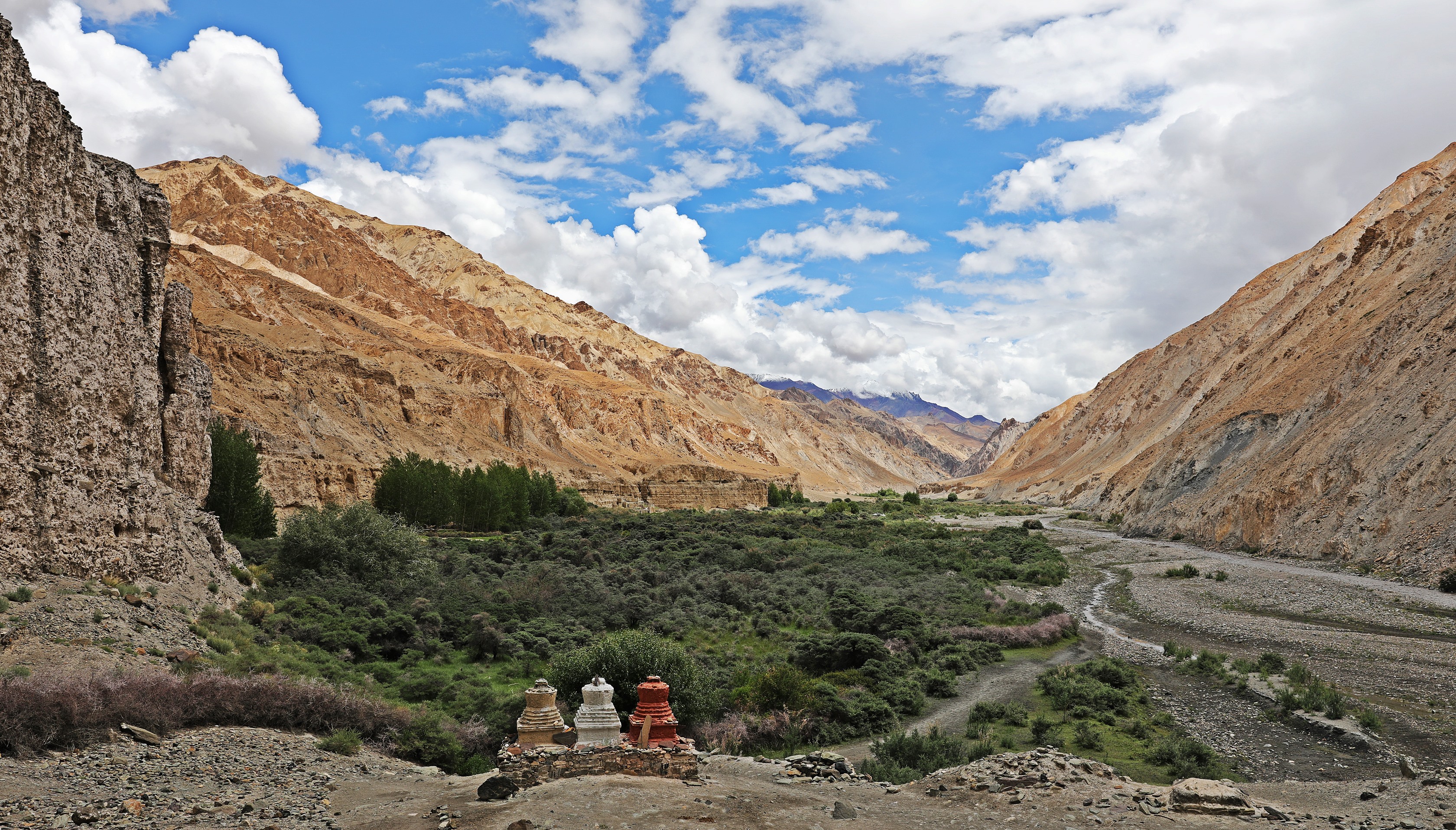
At the end of the gorge (3500m) the trail flattens out and follows the wide valley to the town of Skiu (3435m). Skiu is the nicest town on the trek. From its amazing setting at the junction of 3 valleys to the Tibetan style chortens, mani stones and monastery, Skiu is a very cute village. (2hr 10 min from Shingo). From Skiu the valley heading west leads to Chiling. Some people start or stop the trek there, but you would miss the amazing Shingo gorge.
Day 5 Skiu to Markha – 5hr 20 min; 335m gain


The trail follows the fast moving, chocolate brown Markha River at or near river level for much of the trek. It is a gravel road for ½ hr then becomes a trekking trail passing bushes, trees and fields of crops. The valley is wide and colourful with weather-worn peaks. The trail passes a settlement with a parachute tent and 2 hamlets with homestays. Each are approximately 1 hour apart. The last one, Chalak is separated into 2 areas approx. 200m apart with guest houses in both parts. There are bright green fields of buckwheat and barley at either end of town. The trail climbs to a lookout point with chortens on both sides. Now the trail continues to climb up and down small climbs to avoid the rushing river. When down at river level again you’ll pass a few homestays in the Markha region.
Cross the Markha River on a broken bridge and when you can see the ruins of a fort on a high hill, you have reached Markha (3770m). It is also divided into 2 area, before and after the fort. Once we arrived at our homestay there was a torrential downpour for only 10 minutes, but the flash flooding meant we had to pack up and move to another one. The fortress ruin above Markha isn’t much to visit, but the Gompa above has been renovated and has a nice setting on the hill top with many chortens surrounding. There are 3 more homestays in the 2nd Markha area.
Day 6 Markha to Nimaling- 8hr 16min; 1045m gain


This is a very long day with multiple options to stay to split the day up as noted below. The trail out of Markha continues up the Markha Valley mostly at river level with similar view and terrain as the trek into Markha. There are 3 bridges crossing the river. In 2018 the 2nd bridge has fallen at one end to be a steep downslope with a severe 90° twist. Take it slow, use your hands and you can cross it.
After the 3rd bridge you can see the old Techa Gompa perched high on the cliff above. It looks even more impressive from the other direction, so don’t forget to look back. You pass the hamlet of Umlung with 3 or 4 homestays. From this hamlet the trail goes very close to the river along a narrow man-made ridge. Just before Hankar the trail has been washed out and involves either a 2m scramble, a hop across a large gap, or backtracking to find a path up the slope.
The cute town of Hankar has several homestays and is divided by a steep climb on your left to reach the Gompa. At the end of the 2nd half of town, cross the small stream and climb up and down until the trail splints. Take the trail left. Do not cross the bridge. The trail follows a winding, narrow valley up a smaller river. You’ll pass a few shepherd huts and finally a bridge to cross the river. There are many pikas and marmots in this area.
Thochungtse (4150m) is not to far from this bridge where there is a parachute tent homestay. Pass Thochungtse and find a place to cross the creek. We were there by 2 pm and it was a raging river that was difficult to cross. Mornings are most likely easier.
The trail then goes up the right side of the meadow, over a boulder field and up a steep climb to a look out. Then the trail slowly climbs up and down the ridges and passes a few more hills. By the final ridge you can see the camp of Nimaling (4815m). It has main dining tent and at least 21-2-person tents to rent supplied with blankets and pillows as well as camping spots. When we were there at least 70 people were staying at Nimaling, but they managed to supply a good meal in an efficient manner.
Day 7 Nimaling to Shang Sumdo via Kongmaru La – 5hr 34 min; 335m gain, 1420m descent


From the camp, the trail starts a moderate ascent of the hill behind the shepherd huts. It’s a constant climb of 150m. Then you cross a long plateau to reach the next ascent. You can see the prayer flags at the top of the pass from the plateau. It’s a steep climb with a few switchbacks to reach Kongmaru La (5150m). (1hr 20min).
The view down the valley on the other side is gorgeous. The red and green coloured mountains that border the valley with some greenery part way down make a spectacular shot. It was cloudy for us, but they dispersed about 50m down. It’s a steep 500m descent down a dirt and potentially muddy trail with many loose rocks. You go through a small meadow and then reach in the interesting narrow gorge with the rapid running Shang River. The trail had at least 35 rock-hopping river crossings throughout this gorge. We did it at 10am and were able to cross, but later in the day or if it rains it may be difficult.
The trail then goes high above the river a few times between crossings, adding to the ascents and descents of the day. Finally, the valley widens, and you reach the village of Chogdo (3980m). There are at least 2 home-stays here. After Chogdo there will be a few taxis offering rides to Leh. A further 3 – 5 kms down the road is Shang Sumdo (3670m) where the taxi rates drop by at least half. The trail is on the road though so is not as pleasant as the previous days. There is one home-stay and a campsite here. We took a taxi for 800Rs to the hamlet of Hemis to see the important Gompa of Ladakh.
For more of our treks click here, or go directly to Trek to Phuktal Gompa in Zanskar, India Phuktal Gompa (Zanskar), Hidden Valleys Trek (Ladakh), Kashmir’s Great Lakes, Everest 3 Passes, Manaslu Circuit, Upper Mustang, Jumolhari Yaksa Trek (Bhutan), Pinnacles Trek (Borneo), Carstenz Pyramid.
For pictures from Richard’s Everest summit click here: https://www.youtube.com/watch?v=VFmsecd6yN0


