
Sheer granite towers stand protectively above a pristine glacial lake, creating one of the most iconic scenes in Chile. Hiking to see this stunning natural wonder is a high priority for many who make their way to Torres del Paine National Park in Chile’s Patagonia. In the post below, we’ll take you to those views and describe the trail so you can hike to the base of Torres del Paine, too.
In the Tehuelche language, Paine means Blue, and Torres is Spanish for Tower. Together, the name translates to Blue Towers. This comes from the blue hue seen on the main towers of Paine Massif at certain times of the year.
The Hikes
The most popular multi-day trekking route in the park is the W Route. It travels between Glacier Grey and Base of Torres del Paine, and includes a side trip to Mirador Cuernos and Britanico. It is the Orange W in the map below. The less popular, more rugged way to explore the park is to do the whole loop that encircles the massif and includes the W Route. It is the Red and Orange trail in the map below. We did this hike on a previous trip to the park in 2003 and describe it here. On our most recent visit we did the day hike to the Base of Torres del Paine. This trail is the right end of the Orange W in the map below.
Hike to the Base of Torres del Paine
Distance – 21.2 km (13.2 mi) return; Elevation Gain – 764 m (2,505 ft), Total elevation gain/loss with all of the ups and downs is 1,215m (3,986ft). Max Elevation – 885 m (2,900 ft). Time – 5-7 hours
Access – There are three entrances to Torres del Paine National Park. To do this hike, you need to use the Laguna Amarga Park Gate, where there is a Ranger Station. After checking in at the ranger station, you can take a park shuttle to the trailhead at the Torres del Paine Welcome Centre. The O Circuit Trek trailhead is also at the Welcome Centre. If you are doing the W, there is a shortcut trail so you don’t have to go down to the Welcome Centre.
Tip – The hike is also called Mirador las Torres or Base Torres, and can be tacked on to the end of both the W and O Treks. You can also do it as a day hike without hiking either the O or W. That is the route we took on this most recent trip and is how we’ll describe the hike.

We visited Torres del Paine National Park over 20 years ago, but it was very cloudy and it rained for most of our trip. On this one in 2026, we were excited to re-create some of those views, and hoped we’d have better skies. As soon as we arrived at the Ranger Station, we were treated to an amazing, cloudless view of the famous towers in the distance, so we knew the hike would be much different this time.


The trail begins at the Welcome Centre and follows the flat valley for a while. There are aren’t many views in this first section, but it’s nice to see the unique pre-Andean shrub, Patagonian heather and wildflowers. After passing Hotel Las Torres, though, the steady climbing begins, and there is very little reprieve until you reach the top.


Partway up you’ll reach Paso del Vento, where you can see quite far down the long Ascensio Valley. Poking above the hills is one of the black-topped mountains prevalent in this region. Their unique look comes from light-coloured granite towers topped by dark, sedentary shale.


At the halfway mark (5.7 km, 425m gain), the trail drops down to reach Refugio Chileno. You may not mind this descent on the way in, but you’ll find it very frustrating to have to climb up it on the return. Many trekkers stop for a break and a snack at the refugio. Not only is it a good spot to rest, you can also enjoy the view of the Paine Group poking over the hills above.
The refugio has beds and tent platforms if you want to stay overnight. This is a good option if you want to see the sunrise from Laguna Torre, but you must reserve in advance.


After you’ve walked for half an hour or so from the refugio, you will reach Torres Mirador. From here, the real ascent begins with another 562 m (1,845 ft) to gain over a fairly short distance.
Be aware that upward traffic is not allowed beyond this point after 3 pm, and a park staff member is posted there to ensure no one sneaks by. The park says it is to prevent having to rescue people who attempt to come down in the dark. The spires of Torres del Paine are in the shade by 2 or 3 pm, so it is better to go earlier anyway.

After leaving the mirador, you have a grunt climb ahead of you. The first section steeply climbs up through a healthy lenga forest on a good trail. Once you emerge from the forest, though, in addition to more climbing, you have to navigate a jumbled mess of large boulders, loose rocks and small pebbles on the moraine. This means that it is almost as difficult to go down as it is to go up.
The trail is often very busy, and while up traffic is supposed to have priority, hiking ethics are not always followed.


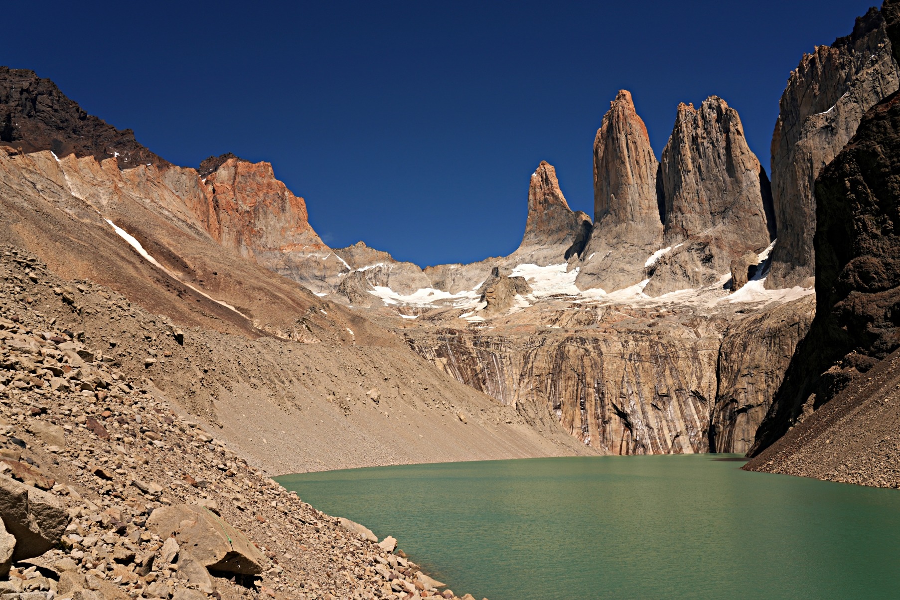
Finally, after a lot of work, you will reach the top of the moraine where you are treated to the view you’ve been anticipating. In front of you, Torres del Paine proudly stands above the green Torre Lake.
We were so happy to have good weather on this trip so we could appreciate this gorgeous scene. On our previous visit, it was raining, and the view of the Torres was not nearly as picturesque (see below). On this day, however, the tall granite spires of Torres Norte, Central and Sur, along with Nido de Condor, were shining under a bright blue sky. These three peaks are what gave the park its name and are often called the Towers or Las Torres.
You can walk down to the shore and climb on the boulders on its edge, but a rope has blocked off a large part of the moraine, so you can’t stray too far.


This is an out and back trail, meaning that every step you took to reach it must be made again in reverse. Take care, especially for the first 400m of descent, because it is very slippery on ball-bearing pebbles. Trekking poles are very helpful.
It was late in the afternoon when we got back to the Ranger Station and the soft light gave us one final wonderful view of Torres del Paine.


Torres del Paine National Park
There are quite a few other hikes and views that you may want to see when visiting. Here are some of the other things to see and do in Torres del Paine National Park:
O Circuit or W Multi-day Treks
The most popular trekking route in the park is the W Route. The less popular, more rugged way to explore the park is to do the O Circuit that encircles Paine Massif. The latter takes you through the wild and remote backcountry before joining the popular W Route to complete the circuit.
We did the multi-day O Circuit hike on our previous trip to Chile, and once you read our post from that trip, you’ll understand why we didn’t want to do it again. You can read more details on this hike in our post Trekking the O Circuit in Torres del Paine.


Lago Nordenskjold and Cuernos Lookout
One of our favourite side trips in Torres del Paine is to see the picturesque Cuernos del Paine. A short hike over grassy hills takes you from the Lago Pehoe Ranger station to the side of Lago Nordenskjold. If you’re lucky, you may spot guanacos grazing on the hills.
From the edge of the lake, we were treated to the best view of the incredible Cuernos del Paine (Horns of Paine) towering over the blue waters of the lake. It was a view we had been looking forward to seeing for the entire trip.


Salto Grande Waterfall
On the trail to reach the Cuernos Lookout, stop to see the stunning Salto Grande Waterfall. It is a popular spot for tourists and can be reached on a short walk from Pehoe Campground and Hotel Pehoe.
If you don’t have a car, it is still easy to reach by taking BusSur to the Pehoe Campground and then follow the trail for about one kilometre.

Lago Grey Boat Trip
Another popular attraction is to take a boat trip on Lago Grey to see Glacier Grey. Boats leave from the Hotel Lago Grey three times a day.

Tips For visiting Torres del Paine National Park
Unless you have a car or are hiking the W or O multi-day routes, Torres del Paine is not really set up for independent travellers. To make the most of your time at the park, you will need to plan ahead.
• Park fees can be purchased online here.
• There are three park gates: Laguna Amarga, Serrano, and Lago Sarmiento. Use Laguna Amarga to hike to the Base of Torres del Paine.
• To reach the park, you can take a bus from Puerto Natales, where there are several companies to choose from. Most drop you off at Larguna Amarga Park Office, but BusSur also drops off and picks up at Pudeto, Pehoe and Hotel Lago Grey.
• To reach the trailheads for Torres del Paine or the O Circuit Hikes, you can take the park’s shuttle from Laguna Amarga to the Welcome Centre. It only does the route 5 times a day, so you need to know its schedule. The first one in the morning matches the early bus from Puerto Natales. The schedule for return trips can be found in the Welcome Centre. The shuttle fee is paid in cash to the driver.
• To reach other day hikes or viewpoints not listed in this post, you need to either have a car or take a tour. The roads are gravel, though, so make sure you are comfortable on mountain roads.
• There is very little mobile connectivity, no ATMS or gas stations in the park, so come prepared.
We have also done other hikes in both Argentina and Chile. You can find all our hikes under Trek-Bike-Ski, or go directly to Argentina’s Refugio Frey and Cerro Llao Llao, Cerro Torre, Monte Fitz Roy, Iruya and Aconcagua. Or Chile’s O Circuit.
Puerto Natales
The best city to access Torres del Paine National Park is Puerto Natales. We spent a few days here on our previous Patagonia trip and could barely remember what the city looked like. On this return visit, we realized why. Puerto Natales is not that memorable. It is a rather run-down maritime town with a continuous biting wind. With a spare afternoon, though, we were able to find a few things you worth seeing.
Costanera Pedro Montt
Located on the edge of Admiral Montt Gulf (Golfo Almirante Montt), Puerto Natales does have a pretty setting. A long pedestrian pathway on the waterfront allows you to enjoy the beautiful views of the snow-capped peaks in the distance. The waterfront is Puerto Natales’ best feature.
As you admire the scenery, you can stop at a few monuments along the way.


Muelle Viejo Old Dock
Although Europeans had explored the gulf in the 1500s, Puerto Natales wasn’t founded until 1911. It was first used as a shipping port for the sheep industry, and most of the population was from the Chiloe Islands, over 1200 km away. Today, all that remains of the old port are the wooden posts, but with the mountains behind it is a nice scene.


Monument of Alberto de Agostini and Monumento al Viento
Father Alberto de Agostini was not just a missionary, he was also an explorer, mountaineer and photographer. He spent much of his free time exploring the wilderness, leaving a large photographic archive of the area. The monument is a sculpture of him shaking hands with a Selk’nam indigenous man.
Not far away is Monumento al Viento. When you live in a place where the wind constantly howls, you have to love it, or you’ll go mad. In Puerto Natales, their Wind Monument (Monumento al Viento) shows that they love it.


Monumento de la Mano
Created by Chilean artist Juan Andrade, la Mano was intended to replicate artist Mario Irarrázabal’s versions in Atacama and Punta del Este, Uruguay. It represents humanity’s desire to reach beyond physical reality. We saw the one in Uruguay only a few weeks earlier, so could compare the two.


Monument of Mylodon
Mylodon is a prehistoric Giant Ground Sloth that once inhabited this region. A large statue along the waterfront remembers these animals, and there is a smaller version of the statue downtown.

Downtown Puerto Natales
Located in the centre of Puerto Natales, Plaza de Armas Arturo Prat is home to a few government buildings and the parish church. Since the town is not very old, though, there aren’t many grand old historical buildings that we were used to seeing in Chile.
You can find a few colourful maritime-style houses, on the surrounding streets, but most of the town is uninspired and run down.


Getting to Puerto Natales
Located in Chile’s Southern Patagonia, most people fly to Puerto Natales. Flights reach the city from Santiago or Puerto Montt. You can also reach it by bus from Punta Arenas (3 hours) or El Calafate, Argentina (6 hours).
Puerto Natales is located at the bottom on the map below. It is an interactive map, so you can zoom-in or click on a marker for a link to our post from that region.
Where to stay and eat in Puerto Natales
Even if you are doing a multi-day hike in Torres del Paine, you will need to spend a night or two in Puerto Natales. The city is not very large and has accommodations for every budget. As with most of Patagonia, expect to pay more for less quality in Puerto Natales.
Most of the restaurants are located in the city’s downtown, not far from Plaza de Armas.
Click on the link to read our Travel Tips For Chile.

To read more of our adventures in Chile, click here.
Coming Next – Punta Arenas and the Magellan Strait
For pictures from other blogs go to Gallery at monkeystale.ca.
To read about more of our adventures go to Destinations.
If you like what you read, please comment or share (with credit) using the links below.


We'd love to hear from you, please leave a comment.