
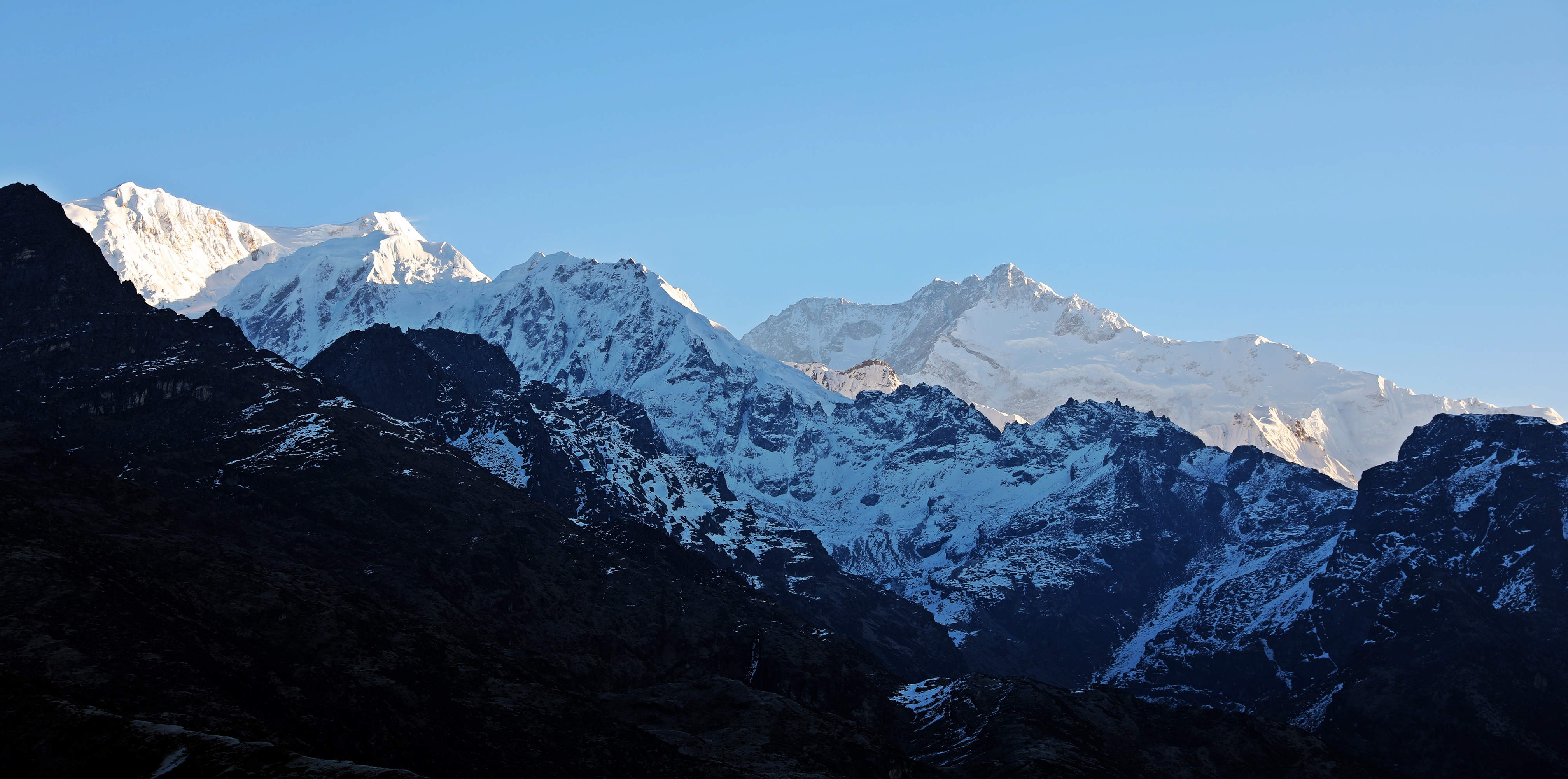
The Yuksom to Goecha La trek is a relatively easy 8-day trek that culminates in a sunrise view of Kanchenjunga, the 3rd highest mountain in the world. The trek begins in a dense jungle, but after a couple of days you’re rewarded with amazing views of the Himalayas including plenty of spots to see Kanchenjunga along the way. This trekking guide for Goecha La describes the trail and campsites and includes pictures of some of the incredible views.
When to Trek – This is a high-altitude trek with snow in the winter and monsoons in the summer. The best trekking weather is in April/May and September/October.
What to bring – In addition to the usual hiking and camping equipment be sure to bring: warm clothing especially for evenings and to sleep (it can get to 0°C at night), rain gear including pack covers and plastic bags for personal items.
Do I need a guide – Yes, you do need a guide. We used Renok Adventures and found them to be very professional with well-maintained equipment and excellent food. Our guide, Pemtuk, was very knowledgeable and we highly recommend him (WhatsApp 91 80012 12599). You can book in advance on-line with many guiding companies or there are local guides in Yuksom that can be booked with short notice. Guiding costs will include transportation from Siliguri, guides, tents, sleeping bags, sleeping mats, meals, trekking fees (Foreigner permits are separate). Mules/yaks for personal gear is an additional charge.
Getting to the trek – Most guiding companies will arrange shared jeeps from the town of Siliguri, West Bengal to Yuksom, Sikkim. The cost is 6000Rs per jeep, one-way. Usually you can share with other people from your trek to split the cost.
You can get to Siliguri by train (Indian Railways) to New Jalpaiguri Railway Station (NJP) or fly into Bagdogra Airport, Siliguri. There aren’t many tourist-ready hotels in Siliguri, so try to arrive the same day if possible. If you’re getting to Yuksom on your own, you can hire a jeep-taxi in Siliguri.
Do I need a permit – Indian trekker permits/fees are usually include in the guiding fees. Foreigners need an Inner Line Permit (no charge) and a Kanchenjunga Protected Area Permit (2000 Rupees in 2019). ILP is the same permit required for other sites in Sikkim if you’re planning visiting other areas before of after the trek. To obtain an ILP permit you will show your passport at the Melli checkpost on the drive to Yuksom. After you get the ILP permit, you need to make 5 copies. Usually when you stop for lunch on the drive you can make copies in the town. The permits are returned in the Rangpo checkpost.
To obtain the KPAP you must have 2 copies of your passport and visa and 2 passport-sized photographs for each trekker. The guiding company will have the necessary forms for this permit in Yuksom.
Note:
• We did this trek at the end of April 2019. We usually woke to a beautiful sunny sky, but by 9 am every day it was cloudy, and it rained every afternoon. This seems to be common in the spring.
• Trekking times listed below do not include breaks for meals etc. Intermediate times are our actual times. Total trekking times are a range of published trekking times. We were not acclimatized during this trek and our times reflect that.
For the full story and more pictures, click here.
Day 1 Yuksom (1700m) to Camp 1, Sachin (2165m)
Trekking time 2 hrs 53 min; Elevation Gain 465m+
The trek begins from the main road in Yuksom, just past the hospital. It starts easy, on a good, dirt trail but if it’s wet, there can be a lot of leeches. After an hour the trail begins to climb up and down, crossing side streams and waterfalls. The closer you get to camp, the ups and downs are more extreme. The trail is mostly through a dense, lush forest so there are not many views on the first day. As you get higher, the trail becomes more rock covered which can be slippery when wet. Camp 1, Sachin, is on a hill with only a few flat campsites. There’s a permanent shelter used by the cooks, and a covered picnic table, but it’s a small area for the number of hikers. The outhouses are awful. Some groups continue to Bhakin on the first day.


Day 2 Camp 1, Sachin (1700m) to Camp 2, Tshoka (2985m)
Trekking time 2 ½ to 4 hrs; Elevation Gain 820m (plus over 120m gain and loss)
From Camp 2, the trail continues climbing through the dense jungle with many ups and downs. There are large rocks on the trail and some flat stepping stones, but otherwise, it’s muddy. At one point after gaining 160m from camp, you lose 120 m to cross Prek River. After the bridge, the climb is much steeper with many switchbacks. As you climb, you start to see rhododendrons and have nice views of the steep valleys and high mountains.
After 2 hours you reach Bhakin, (2750m) where there’s a small store, a couple of buildings and a few spots for tents. Some groups camp here on night one. There are very nice mountain views from the open meadows. From Bhakin, it’s all uphill. The trail is a steep 235m all the way to an open area on the ridge, which is camp 2, Tshoka (2985m). Here, there’s a small shop for drinks, instant noodles and snacks and a few old Tibetan homes that guiding companies use for cooking. The toilets at our campsite were clean and well maintained. The views from camp are beautiful. There’s a small Buddhist monastery and a few chortens at the camp.


Day 3 Camp 2, Tshoka (2940m) to Camp 3, Dorung (4120m)
Trekking time 3 ½ to 5 hrs; Elevation Gain 1180m
There’s a lot of elevation to gain today. The trail begins beside the monastery and climbs through a tight rhododendron forest. The muddy trail switchbacks for about 600m elevation gain with only a few flat areas for a reprieve. In this area the trail has large rocks, boulders and wooden boards which can be slippery. After gaining 640m you arrive at a shelter, Phedang (3650m), in an open meadow. The trail continues up through the forest, but is now sandy and less muddy. You climb to a ridge with nice views (if it’s not cloudy).
Then the trail goes up and down 3 or 4 more times along this ridge to reach Dzongri Camp (3956m)(3hrs). It’s a large open area, with many camping sites and filthy outhouses. There are 2 small shops selling snacks, and buildings for guiding companies. Most groups stay here, but we continued up a steep gully to another open plateau, Dorung at 4120m. We’re glad we stayed here because it has incredible mountain scenery whereas, Dzongri is in a valley with no views. But the downside is that it is windier and colder; but the views are worth it. There are no shelters or toilets here.


Day 4 Camp 3, Dorung (4120m) to Dzong Ri Lookout, to Camp 4, Thansing (3930m)
Time to Dzong Ri lookout 30 min; Time to Thansing 2 ¾ to 5 hrs;
Elevation gain/loss 130m to Dzong Ri Lookout; Descend 330m then Ascend 250m to Thansing
From both Dzongri and Dorung Camps you can easily access the lookout on the top of Dzong Ri (4250m). From Dorung it’s a quick 20 – 30 min hike on a good trail. Follow the main trail until it veers to the right up a small hill. The trail goes up and over this hill to arrive at the base of Dzong Ri, then it’s a good trail up to the top. You can see the prayer flags from below. The total elevation gain is approximately 130m. Most parties go for sunrise and in the fall its worth it to arrive before sunrise for the alpenglow. We were there in the spring and the alpenglow wasn’t very bright, but still made a gorgeous view. You should be on the summit at 5am or earlier for the alpenglow.
After watching the sunrise you’ll return to camp for breakfast before heading off. The trail continues passed the Dzong Ri Lookout turnoff. It’s a sandy trail surrounded by juniper bushes and dwarf rhododendrons. The trail goes up and down a lot, but the highest point you reach is only 55m above Dorung camp. From this high point you can see the Prek River below and the next campsite in a green clearing in the distance. All around you are the high Himalayan mountains. There are cairns marking the trail and when you arrive at a pair of chortens, the trail takes a steep, knee-jarring 340m descent on steep rock filled switchbacks through a rhododendron forest. At the bottom is Kokchorung, a camp that you’ll stay in on the return.
There are 4 bridges crossing the Prek River. Then you follow the river, walking through a boulder field, then a mossy forest, slowly increasing elevation until finally you arrive at Thansing Camp (3930m). It’s on a large open meadow above tree line with a few buildings used by cooks. The outhouses are disgusting. You have a great view of Kanchenjunga’s ridge at the end of the valley. On the last picture below you can see the ‘thumbs up’ rock. Goecha La is below that feature.


Day 5 Camp 4, Thansing (3940m) to Camp 5, Old Lamuney (4175m)
Trekking time 1 ½ to 2 ½ hrs; Elevation Gain 220m
This is a very short, easy day. The trek continues across the meadow, slowly increasing in elevation. New Lamuney Camp is reached in 1 hr 15 min where some groups set up camp. There is one building and a dirty toilet. Old Lamuney Camp is another 15 min away with no buildings or outhouses. Just before camp there is a long mani wall (Lamuney means long mani wall). There are impressive mountain views from both Lamuney camps You will have a lot of extra time today to explore. We hiked to Samiti Lake which is on the path to Goecha La. It’s a good, well-marked trail, up and down the moraine ridges (40 min). The campsite is very windy and cold at night.


Day 6 Camp 5, Old Lamuney (4150m) to Goecha La (4940m) to Camp 6, Kokchorung (3680m)
Trekking time to Goecha La 1 ½ to 2 ½ hrs; Trekking time Goecha La to Kokchorung 2 ½ to 5 hrs; Elevation gain 490 m to Goecha La; Elevation loss 1260m to Kokchorung
You’ll wake up early to get to Goecha La for sunrise. The trail immediately climbs up the moraine on the right side of the valley following well marked cairns on a good rocky trail. You’ll reach a high point before descending to Samiti Lake (40 min). The trail goes on the right side of the lake either on the sandy beach, or a little higher on a trail if the water is high. If the water is very high, there’s another trail on the left side of the lake. At the far end of the lake, the trail climbs up the gully. You can see a vague trail on the last photo above. Near the base of the climb, you have to rock-hop across the stream to get to the left side. Continue up the side of the creek until it flattens out and then the trail veers left, and you can see the pass. The trail goes to the top of the pass and then turns right to follow the ridge to its highest point.
Goecha La is marked with prayer flags and offers a 360° view of Kanchenjunga, Padim and the surrounding Himalayas. The clouds usually come right after sunrise, so most groups get there early. Unfortunately for us, it was cloudy when we woke and the sky didn’t improve so we didn’t get a clear view of Kanchenjunga. After watching the majestic peaks, it’s time to head to the next camp. Return the same route to Kokchorung Camp.


Day 7 Camp 6, Kokchorung (3680m) to Camp 7, Tshoka (2941m)
Trekking time 3 ¾ to 7 hrs; Elevation loss 600m
From camp, the trail takes a lower route so you don’t have to climb up to the Dorung plateau. At a T-intersection, the trail on your right starts to climb, take the lower trail straight ahead. It’s a narrow trail with a sheer drop on one side and a mountain wall on the other. Horses and yaks can’t navigate the narrow trail, so they turn right and go back up the hill. The narrow trail goes up and down a lot without ever losing absolute elevation. It goes up over ridges, but then down over streams. After 2 ½ hours you reach the shelters at Phedang and have come full circle to the regular trail. Here though you are only 30 m lower than Kokchorung. From Phedang the steep trail down is mostly on the wood boards which are very slippery if its wet. It continues all the way down to Tshoka.
Day 8 Camp7, Tshoka to Yuksom
Trekking time 4 to 6 hrs; Elevation loss 1200m
Today retraces the same route back to Yuksom with all of its ups and downs. Since you’re acclimatized, the 120m climb after the bridge, won’t feel very difficult. You can see Yuksom in the distance, but because of all of the ridges, there’s a lot of walking before you get to it.
Coming up next: Top 15 pictures from India
For more of our treks click here, or go directly to Source of the Ganges (Uttarakhand), Kuari Pass (Uttarakhand), Hampta Pass (Himachal Pradesh), Great Lakes Trek (Kashmir), Markha Valley Trek (Ladakh), Hidden Valley Trek (Ladakh), Phuktal Trek (Zanskar), Everest 3 Passes Trek (Nepal), Manaslu Circuit (Nepal), Upper Mustang Trek (Nepal), Jumolhari Yaksa Trek (Bhutan), Kalaw to Inle Trek (Myanmar), Pinnacles Trek (Borneo), Carstenz Pyramid (Indonesia).
For pictures from Richard’s Everest summit click here.
For extra pics from this trip go to Gallery/Northern India. For extra pictures from other blogs go to Gallery at monkeystale.ca
To read about more of our adventures go to Destinations.
If you like what you read, please comment or share it using the links below


We'd love to hear from you, please leave a comment.