
Exploring the surreal Atacama landscapes on a bicycle is one of the best ways to experience what this desert has to offer. We mountain biked in two different areas, Garganta del Diablo and Valley de la Luna and loved seeing these wilder parts of the desert. Here is a brief guide to these bike routes.
What to see in the Atacama Desert
With a wide variety of surreal landscapes spread across the vast Atacama Desert, deciding which to see can be difficult. There are dozens of tour agencies offering very similar day tours to the many sites in the area, but choosing which to see can be daunting. We have presented these widely varied landscapes in three separate posts so you can see what each has to offer and hopefully make it easier for you to decide which ones you want to visit. They are grouped based on proximity to one another because whether you drive, take a group or individual tour, it is the most efficient way to see as much as possible.
In this post, we’ll take you on the mountain biking trails in Garganta del Diablo and Valley de la Luna. You can have a look at the other scenes in the Atacama in our posts Piedras Rojas, Chaxa and Altiplanic Lagoons; and El Tatio Geysers, Rainbow Valley, and Baltinache Lagoons.
The sites in the Atacama are marked on the map below. It is an interactive map, so you can zoom in or click on a marker for a link to our post from that site.
Garganta del Diablo
Distance – 18 km (11¼mi) roundtrip loop from San Pedro de Atacama. Elevation Gain is minimal, but there are hikes to lookouts require 200-300 m gain.
In the map below, the black line is the regular route, which is quite flat. The red line is a short-cut. If you take it, be aware that it travels up and over sandy and scree slopes that are difficult to ride, so will likely require a lot of pushing.

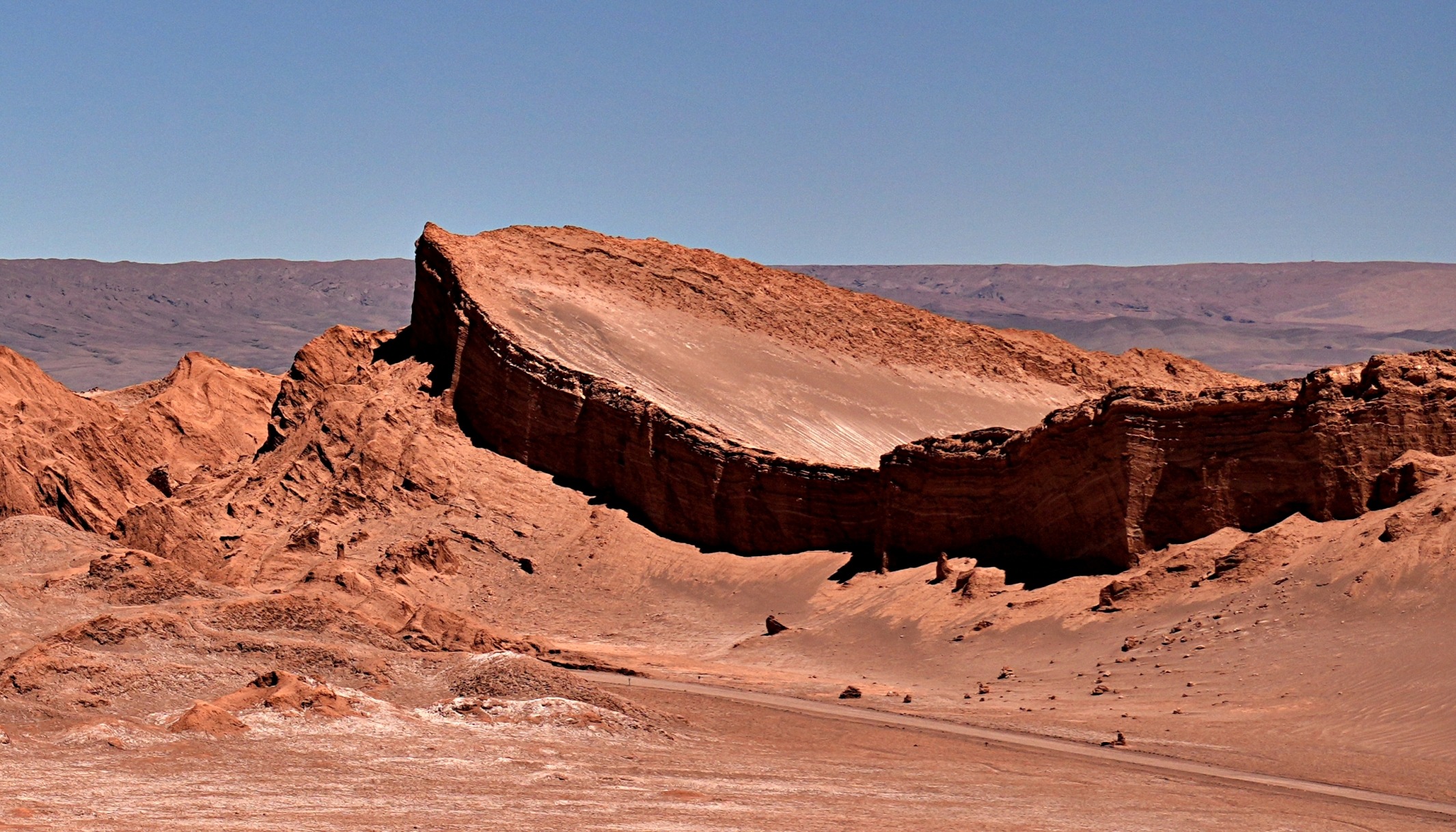
Garganta del Diablo (Devil’s Throat) is known to be one of the best mountain bike trails in Atacama. It is a fun ride that travels through the twists and turns of an extremely narrow gorge that seems to have been shaped by nature specifically for biking.
The gorge is located in the Catarpe Valley Park, not far from San Pedro. After entering the park gates, you have a 3 km (1.8 mi) flat ride on a gravel road. The time goes by quickly because you are distracted by the red, weather-worn mountains all around.


After 3 km, you reach the entrance to Garganta del Diablo, also called Quebrada de Chulacao, where the landscape changes dramatically. Instead of a wide, open valley, the ride travels on a narrow canyon floor between walls of clay, gypsum and salt. Evidence of these minerals is seen in the canyon, especially in the calcium veins embedded in the walls.


Not only is the canyon spectacular to look at, but the convoluted trail constantly swerves between the walls like a slalom ski run, but on flat ground. This is what makes it so much fun to ride.

The deeper you get in the canyon, the tighter it becomes, until you reach a very narrow slot in the walls called the Garganta del Diablo, or Devil’s Throat. It is so narrow that you almost think your bike’s handlebars won’t fit through, but they do. This twisting trail is one of the most unique canyons we’ve seen, certainly the most extraordinary that we’ve biked.


As you ride through these twists and turns, there are a few obstacles to avoid. The overhanging roofs, narrow passages and sudden drops keep you on your toes, but they also make it fun. Most of it is easy, but there are a couple of spots where most riders will need to get off their bikes to either climb up or down small steps and jumps. These are marked with pylons, so do pay attention to these warnings.


At the end of the Devil’s Throat, the canyon opens up to a rugged, arid valley that looks to belong on another planet. You can see in the first picture below that the trail still 8doesn’t travel in a straight line.


In this open area, there are a few hiking trails to viewpoints on the nearby mountains. Even though you’re tired from the ride, it’s worth the hike for these views. From their tops, you have a phenomenal view of the surrounding volcanoes and San Pedro de Atacama, far below.


The trail ends on the highway, and in order to return to downtown, we decided to bike through a different part of San Pedro. In this less touristy part of the town, the homes were quite rustic and not as well cared for.

Tips
• We did the route in the CW direction, beginning at the Catarpe Valley Park entrance. It appears that if you go in the CCW direction, you may avoid paying park fees, but it is inexpensive, and fees go toward park maintenance. (5,000CLP/$5USD in Nov 2025).
• There are also many other biking trails in the canyon for more advanced riders.
Valle de la Luna
Distance – 22 km (13 1/2 mi) return from park gates; Elevation Gain – 120 m (400 ft). In addition, the hikes to the miradors are 100-200 m (330-650 ft) each.
This 11 km (6 3/4mi) long valley is popular for sunset tours, but it is so close to the city that you can easily visit it on your own. If you don’t have a car, you can reach it by bike, which is what we did.

It is an out-and-back trail that begins with a five kilometre (3mi) flat section. The wide valley is guarded from above by eroded brown hills, making you think you did indeed travel to the moon. Some have dramatic tops, and others are covered in sand. This landscape has been shaped for millions of years and is a part of the much larger Cordillera de la Sal (Salt Mountains).


After 5 km, there is a long, slow climb up the hill. It wouldn’t be too bad to bike, except that the road is a mix of gravel and sand. In many areas, the sand is so deep that it’s impossible to ride. At least these places give you a good opportunity to get off your bike to rest and take in the amazing views.


Side Hiking Trails
On the side of Valle de la Luna, there are a few different hiking trails. Note, the first stop, Salt Caves, was closed due to damage when we visited in November 2025. Here’s what you can see on the others:
Dunes Mayor Hike – At the top of the hill is the first stop, Dunes Mayor Hike. This short trail climbs up to two viewpoints at the top of a large sand dune.


From the second viewpoint, you have a great view of a feature called The Amphitheatre. Its striations reveal the many layers of volcanic ash deposited over millions of years. It is beside the road, but it is better to see this feature from above.


Achaches Hike – A short ride away is the second stop, Achaches Hike. The trail takes you up close to some of the interesting features in the cliffs. In the first picture, we see the Amphitheatre from another angle, but this hike also lets you see the lunar landscape away from the road.


Although it isn’t a long walk, you can see a large variety in their faults and folds. They were formed from volcanic activity, small, frequent tremors and large earthquakes.


Salt Mine Hike – Another spot allows you to walk through an old salt and gypsum mine. There’s not much left of the mine, but it gives you another opportunity to see this bizarre landscape.


Tres Marias – At the 11 km mark, the road ends at Tres Marias (Three Marys). Composed of granite, quartzite and clay, there used to be three pinnacles, for the three Marias, but one collapsed. In addition to the Marias, there are a few other pinnacles in the area, too. After seeing these features, it’s easy to understand why this area was a site for sacred rituals of the indigenous Lickan-Antay.


Overall, it is a nice valley, but we wouldn’t put it at the top of the list. Many people recommend visiting it at sunset, but we visited midday, so we didn’t see the sunset. The most popular sunset spot is actually outside the park, on the main road to Calama. But we heard that it also didn’t live up to expectations.
Los Flamencos National Reserve Fees and Rules – Valle de la Luna is located in the Los Flamencos National Reserve. The park fee (12,700 CLP/$14USD) is paid at the park gates, where there are washrooms. Park staff will give you a map and review the many rules you must adhere to while visiting the park, which include:
• Visitors must drive or bike; hiking on the road is not allowed.
• Food is not allowed.
• You must wear a bike helmet.
• Entry times for bicycles is 9 am to 11 am. Cars or motorcycles can enter between 9 am and 5 pm.
Tips for biking in Garganta del Diablo and Valle de la Luna
- The dry desert, strong sun and high elevation mean you need to bring plenty of water and protection from the sun.
- The viewpoints are only reachable on foot, so bring a lock for your bike.
- Several agencies in town rent bikes, including e-bikes. As well, many hotels have them available for their guests. Some of them also offer guided biking tours.
- Interactive trail maps can be found on Trailforks, Alltrails and Mapy.cz.
- Another option is to bike in Valle de La Muerte (Death Valley), located in the same area.
There are more things to see in the Atacama. You can find out about these sites in our posts, Piedras Rojas, Chaxa and Altiplanic Lagoons and El Tatio Geysers, Rainbow Valley, and Baltinache Lagoons.

Click on the link to read our Travel Tips For Chile.
To read more of our adventures in Chile, click here.
Coming Next – Putre in Chile’s Remote North
For pictures from other blogs go to Gallery at monkeystale.ca.
To read about more of our adventures go to Destinations.
If you like what you read, please comment or share (with credit) using the links below.


We'd love to hear from you, please leave a comment.