
Istanbul’s strategic location on the Bosphorus Strait was coveted by many dynasties over the centuries. Connecting the Sea of Marmara, a part of the Mediterranean, with the Black Sea made the strait an important shipping route for trade and commerce. Since those early days the Bosphorus, its inlet Golden Horn and Sea of Marmara have shaped the way this city looks and operates. Today, these connected waterways give Istanbul a long waterfront that is a key component of its vibrant personality.
A settlement has been on this site as early as 667 BCE when it was known as Byzantium. For the next few centuries many battles were won and lost to gain control of this coveted land. Warring empires included the Greeks, Persians, and Romans until eventually the Eastern Roman Empire was able to hang on to it for over 1,100 years. Constantine became Emperor of the Eastern Roman Empire, more commonly called Byzantine, and made Byzantium their capital. It was then renamed Constantinople. The Byzantines were eventually defeated in the 15th century by the Ottoman Empire. At the time the Ottoman capital was on the other side of Sea of Marmara in Bursa. Once they controlled Constantinople, they renamed it Istanbul and moved the Ottoman capital there.
Today, the Bosphorus Strait, Sea of Marmara and Golden Horn are still important to the city. Bosphorus separates Istanbul into two continents, Europe and Asia. The city is further divided by the busy Golden Horn. Long walkways along these bodies of water allow you to explore the area by foot which turned out to be one of our favourite things to do.
Bosphorus & Golden Horn
Surrounded by water means that Istanbul has an extensive coastline. On the edge of Fatih District, lies the confluence of Bosphorus with the Sea of Marmara. A long promenade hugs the shore and allowed us to explore it by foot.
From the boardwalk we could see the Asian part of Istanbul on the other side of Bosphorus. We didn’t have time to explore the Asian part of the city, but its hilly landscape adds interest to the waterfront.


Its location on Bosphorus Strait was the main reason that the Byzantines made it their capital. To protect this valuable location they built a large, stone wall around its perimeter. When we were walking along the shore we found ourselves beside the remains of the 5th century City Walls, also called the Walls of Constantinople.


On our walk we passed dozens of men fishing, having picnics and swimming in the cold water. Set up on the rough rocks, their picnics were quite elaborate. Some brought small tables and chairs, others had fancy wood burning stoves to heat their tea. We first explored this area on a Sunday, and assumed it was a part of their relaxing weekend. It turns out this isn’t just a Sunday activity. We continued to see these groups of men throughout the week.

Further along the shore we reached the confluence of the Bosporus and the Golden Horn. This waterway is a deep inlet and divides the European section in two. The water always seemed to be busy with ferries and tour boats jetting back and forth. From the boardwalk we had a picturesque view of the historical buildings climbing up the small hills on the other side of Golden Horn.


Galata Bridge
Galata Bridge crosses Golden Horn, connecting the two European sides of the city. It has a lively atmosphere with pedestrians strolling back and forth and fishermen casting their lines in the water. The backdrop to this scene is the large, picturesque Yeni Mosque.

Galata Tower
Crossing Galata Bridge takes you toward Galata Tower. The original 5th century wooden watchtower burnt down long ago and was replaced in the 14th century. The cylindrical tower can be seen from many parts of Istanbul’s Old Town, and has become a symbol of the city.


The steep streets leading up to the tower are lined with tourist stores and coffee shops. We thought it would be a nice area to stay if we hadn’t already booked our hotel on the other side of the inlet.


Galataport
Below the tower, on the banks of Golden Horn, is Galataport. A long promenade lined by restaurants on one side and Golden Horn on the other gives it a nice atmosphere. Even with huge cruise ships docked on its side, Galataport boardwalk never seemed hurried. From this side of the waterway we could see the vantage point that was enjoyed by Topkapi Palace, Hagia Sophia and Blue Mosque high on a hill in Old Town.
The boardwalk continues and follows Bosphorus Strait for quite a while. It’s a pleasant place to go for a walk, especially at sundown when the light shines softly on the city.


Basilica Cistern
In addition to the waterways, there are other fascinating water sites in Istanbul. One of our favourites was Basilica Cistern.
Even though the city of Istanbul is surrounded by water there was no natural source for drinking water within the city walls. As early as the 2nd century AD, aqueducts were built to bring fresh water into the city. Large cisterns were used to collect and store the fresh water. In the 6th century, Byzantine Emperor Justinian built many cisterns under Istanbul’s streets. In total at least 200 cisterns were built in Istanbul. These massive water storage facilities met the water needs of the city for centuries.
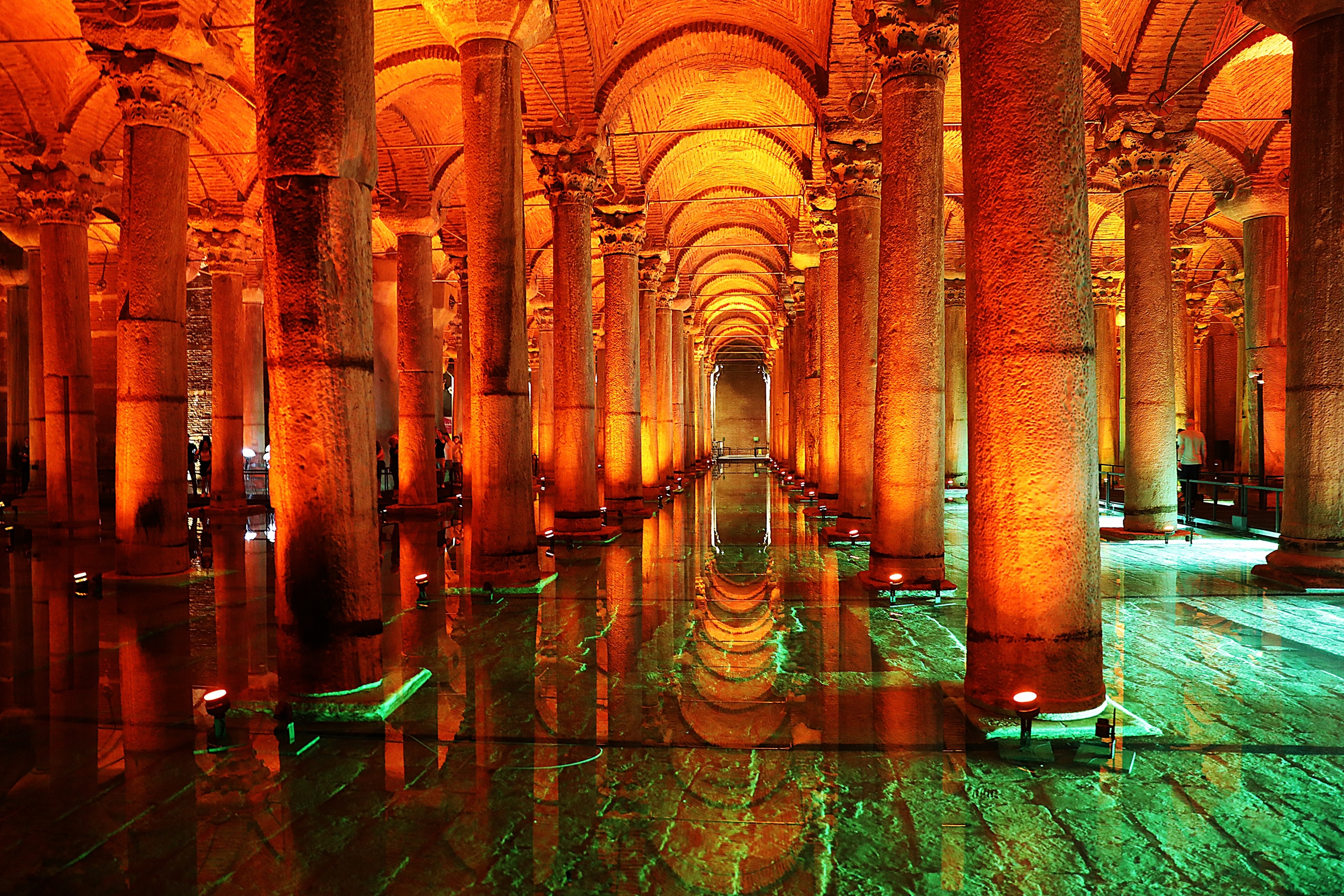
Basilica Cistern is the largest and likely the most beautiful reservoir. It was built under a basilica which is how it got its name. Once you see it though, you would be forgiven if you thought its name was based on its appearance. The space feels more like visiting a basilica cathedral than a cistern.


We were quite taken aback by the serene setting and also by the overwhelming grandeur of the cistern. The Basilica is much larger than we expected. At 143 metres long and 65 metres wide, it could hold 100,000 metric tons of water.
There are a remarkable 336 tall, marble columns supporting the roof of this large cistern and a raised platform lets you walk between them. Lighting illuminated the columns making them cast long shadows which increased the mystical feel of the cistern.


For a space that likely didn’t have many visitors, it was remarkable to see the details that went into the design. Columns had carvings etched on their shafts and gorgeous sculpted crowns on their tops.

At the far end of the room are two Medusa heads. One is upside down, the other lies on its side. It’s not really known why they are there. One theory is that it was common practice to put pagan symbols upside down in Byzantine buildings. Another theory says they were simply left over from another build. No matter the reason, they are a little spooky in the back corner of this dimly lit room.

Entrance – 350 TRY (As of Autumn 2023); Opening hours – 9:00 am – 6:30 pm.
Markets and Street life
It wouldn’t be a Turkish city without a few bustling markets and busy streets. Not far from Galata Bridge is the touristy Egyptian Market. Also called ‘Spice Market, it is held in a beautiful historic building that is part of Yeni Mosque Complex. Stalls sell spices arranged in colourful piles as well as Turkish Delights and Baklava. Not far away is the covered market of Grand Bazaar, the largest bazaar in Istanbul.
On the streets between these two are more markets and shops that are all busy with both locals and tourists. If you like people watching, this is the area where you want to be.


Away from these shopping districts we found quiet streets with heritage homes. It was on these residential streets that we met Istanbul’s other residents; cats. There are hundreds of thousands of cats in Istanbul. Most are street cats, but they are well looked after by locals. In Istanbul and in fact throughout Turkey, we saw many people setting out food and water for their feline friends. As well, there are many cat houses set in yards, on sidewalks and in parks. Cats are considered clean animals and were a favoured pet of Prophet Mohammed therefore, they are adored by most Muslims. The unwritten rule is that the street cats belong to everyone and no one.


Princes’ Islands – Büyükada
A short way off Istanbul’s Asian coast, in the Sea of Marmara, are a group of group islands called Princes’ Islands. During the Byzantine and Ottoman Empires these islands were used to exile those out of favour with the leaders.
The only way to reach these islands is by boat. We took a ferry that cruised up the Bosphorus on the way to Sea of Marmara. The ferry took us by the Asian side of the city where we saw more mosques and palaces.


Not far from shore was Maiden Tower. The watchtower used to have chains running from it to the opposite shore to prevent enemy ships from entering the Bosphorus.

The ferry made stops at each of the Princes’ Islands on the way to our destination, Büyükada Island. All four islands are small with tree covered hills climbing up from shore. Marinas and beaches fill in their bases. Our ferry ride felt like a cruise boat because it allowed us to enjoy Istanbul’s pretty coastline.


After stopping at the first three islands, we finally reached the largest, Büyükada Island. We had heard that there were many old, wooden homes that were once built and used by the political exiles. Today, the islands are touted as being an escape from Istanbul with quiet streets, historic homes draped in flowering bushes. In reality, Büyükada felt more like a tourist trap. Once we got off the ferry in the city of Adalar, we were in the middle of a mess of busy streets with restaurants and shops crowding in the space and literally hundreds of tourists rushing between them.


As we walked up the hill above the restaurants, the streets did get quieter. But we only found a few of the historic, wooden homes in good condition. Many were in disrepair and many more were hidden behind tall walls so we couldn’t see the buildings. Here are a few of the ones we could see.


On the ferrry ride back to the city, we crossed paths with a large flock of storks. The cacophony of hundreds of honking birds was a welcome sound to the hustle and bustle of the islands.

The best part of the day was the ferry ride to and from where we could see Istanbul’s coastline as well as the islands. From the ferry they looked cute, but they weren’t our idea of idyllic.
How to get to Princes’ Islands
The ferry to Büyükada leaves from Kabatas Ferry Terminal and is listed by its city, Adalar. Ferries leave every hour on the hour, except Sunday when they leave 5 min past the hour. The ferry stopped at the neighbourhood of Kadiky on the Asian side of Istanbul, as well as the other islands on its way to the largest island of Büyükada. We arrived at the first island in an hour and Büyükada in an hour and a half.
Note – They are also called Prince’s Islands and Princes Islands
Where to eat Istanbul
The neighbourhood of Karaköy, near Galataport, is a popular part of town where you can find restaurants for almost any budget and cuisine. There are also several restaurants in the Sultanahmet neighbourhood on the streets below Hagia Sophia.

Where to stay in Istanbul
Most sites that you want to see in Istanbul, especially on your first visit are in the Sultanahmet neighbourhood. We suggest staying at one of the many hotels within walking distance of the square. On the other side of Golden Horn, near Karaköy, there are also a lot of hotels and restaurants. Either are great, safe areas to stay.
Click on the link to read our Travel Tips For Turkey.
Click on the link to read more of our stories from Turkey.


This article is now featured on GPSmyCity. To download this article for offline reading or create a self-guided walking tour to visit the attractions highlighted in this article, go to Walking Tours and Articles in Istanbul.
Coming Next – Bursa – The First Ottoman Capital
For pictures from other blogs go to Gallery at monkeystale.ca
To read about more of our adventures go to Destinations.
If you like what you read, please comment or share (with credit) using the links below.




We’d love to hear from you, please leave a comment.