
The Sintra Mountains seem to tumble down toward the coast and suddenly drop into the Atlantic Ocean at Cabo da Roca. The result is a long stretch of sheer, rocky cliffs with dramatic coves. The best way to explore this rugged part of Portugal’s coast is to walk above them and try to spot their hidden beaches below.
Cabo da Roca Hike
Located in Sintra Natural Park, the hike from Cabo da Roca to the town of Azenhas travels along the top of these cliffs, high above the ocean. You can either follow a mostly gentle trail, or take any of the side trails to make the trail much more rugged. Either way, you’ll be treated to spectacular views of this wild coast.
We began our hike at Cabo da Roca Lighthouse. Set on the westernmost point of Portugal, and of mainland Europe, the lighthouse has been a beacon for ships since the 1700s. The hiking trail weaves its way between icy-plant succulents (also called sea fig) as it brings you closer to the coves created by breaks in the tall cliffs. We were glad to be there in the fall when the succulents had started to change colour. In the spring though, these plants would be in bloom so it would also be very picturesque.


There are many trails intersecting with each other in this area allowing you to make your own route. Officially, it is Trail PR-7; a 12 km trail with 450 m (1,500 ft) elevation gain and loss, but depending which trails you take it can be much more.
We first approached the sea stacks around Aroeira Beach (Praia Aroeira). It is a stunning view with the green and red hills in the foreground and the sandy coloured islands jutting out of the gorgeous blue water ahead. There’s a small beach below, but the trail looked quite tricky to reach it.

The further we walked, the better the views of this fantastic coast. We followed a trail that took us to the bottom of one ridge and then back up the next. The reward of this climbing though, was that it got us closer to the next cove that boasts an even prettier setting. More tall sea stacks dot the tight cove that has also allowed room for a beach at its base.
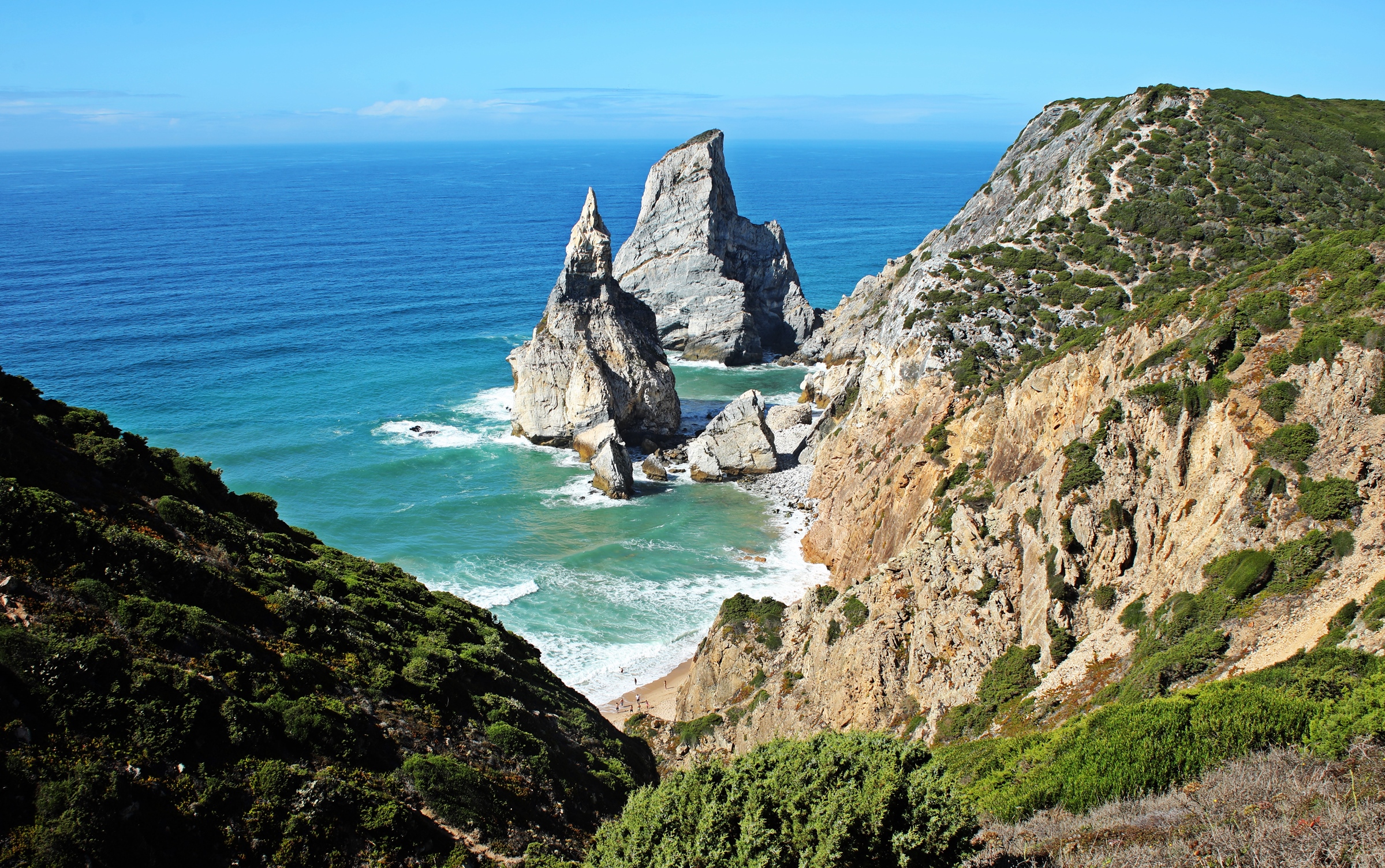
Ursa Beach (Praia da Ursa) is one of the most popular beaches in the area, but you have to work to get there. A steep trail travels down the gorge to the sandy beach at the bottom.


Wanting a better look at this scene we followed a very rough trail down to the bottom and then back up to the cliffs, high above these features. It gave us one of the most spectacular coastal views we’ve had. This trail is very steep with loose rocks, so isn’t for the faint of heart.


From the top of the cliff we could see all the way to the town of Azenhas. The trail is easier here and we walked along the ridge top for a while, but the coast was getting less and less picturesque so we decided to turn around.

On the way out, we stopped at a lookout point that is reachable by car. It does give a nice view, but we’re very happy that we put in the effort to get closer and be treated to the views we had.

Cascais
Not far from Cabo da Roca is the popular city of Cascais. Its location at the mouth of the Tagus River meant it was the perfect spot to set up defensive forts. The first to be built was the citadel in the mid 15th century. Fortress Nossa Senhora da Luz (Our Lady of Light Fortress) was added shortly after which expanded the previous protective walls.


Both were damaged extensively in the Lisbon earthquake, but restoration work has been done on it recently. There is a small museum inside, allowing you to see the buildings that are within the citadel. Most are empty except for a cafe, but its worth a quick visit. It’s free to enter.

Cascais is also home to Portugal’s oldest lighthouse. Santa Marta Lighthouse was built in the 17th century. Originally it was part of a fort, but that was demolished many years ago. There’s a small beach on the inlet beside the lighthouse, called Saint Marta Beach (Praia de Santa Marta). There were quite a few people on this small beach and swimming in the crystal clear water of the inlet.


Located only 30 km from Lisbon, the former fishing village of Cascais has been a summer retreat for Portugal’s nobility for years. Today, its beaches are a draw for both Lisbon residents and tourists. Praia de Rainha and Praia da Duquesa are very popular and close to town.


The city’s small old town is steps away from its popular beaches. It’s not a large historic area, but there are quite a few well-kept, beautiful old buildings to see.


Since it’s very close to both Sintra and Lisbon, Cascais is often used as a base to see the sites of Lisbon, Sintra and Belém.
Boca do Inferno
A little further down the coast is Boca do Inferno (‘mouth of hell’). It is a large archway that the sea has carved out of a rock formation that juts out into the ocean. On the walk to see it, we had more lovely views of this Atlantic coastline and another lighthouse in the distance.


How to get to Cascais & Cabo da Roca
The train ‘Linha de Cascais’ connects Lisbon with the historic city. Trains leave from the Cais do Sodré train station in Lisbon. There is no public transportation to Cabo da Roca though. You could take Uber or a taxi from either Lisbon or Cascais, but it may be difficult to get a ride back. The best option is to have your own vehicle.
Portugal Maps
The first map below shows the location of the sites we explored in Portugal. The second map is an expansion of the southern half. You can click on either for a closer look. Cabo da Roca is on the westernmost tip.


We’ll link this post to our friend Jo’s blog Restless Jo. She has a weekly post entitled Jo’s Monday Walks. Jo recommended this hike to us, so I’m sure she’ll love to share it.
To read more of our adventures in Portugal, click here.
To read more of our hikes around the world go to Treks.
Coming Next – A Day In The Fortified Town of Óbidos
For pictures from other blogs go to Gallery at monkeystale.ca
To read about more of our adventures go to Destinations.
If you like what you read, please comment or share (with credit) using the links below.


We'd love to hear from you, please leave a comment.