
Driving the Georgian Military Road from Tbilisi to Stepantsminda transports you from the foothills to the snowy peaks of Georgia’s Caucasus Range. This iconic route takes you on a journey, passing historic landmarks as it travels through breathtaking mountain scenery. Some people drive this route just to explore one or two of the sites, but we continued almost to its end, to the mountain town of Stepantsminda.
Come with us as we show you some of the highlights you can find when you travel on the Georgian Military Road. We’ll also introduce you to the town of Stepantsminda, in Georgia’s north.
Stepantsminda is located in the middle top of the picture, not far from the Russian border. Tbilisi is straight south of it. The Georgian Military Road is the highway connecting the two. It is an interactive map, so you can zoom-in, or click on a marker to be find a link to our post from that region.
Georgian Military Road
Throughout history, this passage through the towering Caucasus Mountains was used by everyone from merchant traders to invading armies. Tribes from Chechnya, Dagestan and Mongolia are known to have passed this way during their raids of Georgian communities. Medieval watchtowers can still be seen on hilltops along the road, remnants from those times of war. During times of peace, merchants used the high Jvari Pass to carry goods through the mountains.
Traffic began to change in the 18th century when the Russian military crossed these mountains on its way to help defend Georgia from Ottoman armies. From then, its importance to the Russian military grew. By the late 1700s, military engineers designed and built a road that followed much of the same path that we see today.
Considered one of the most beautiful drives in Georgia, today the road is not only used for transportation of goods, it is a destination on its own. Most tourists, both Georgian and foreign, take their time on this route so they can stop to enjoy many of the scenes along the way. We hired a driver through GoTrip Georgia so we could do the same. With all our stops and the slow traffic, the 150 km (90 mi) drive took 4 ½ hours.
Here’s what you can expect to see when you travel on the Georgian Military Road.

Mtskheta and Jvari Monastery
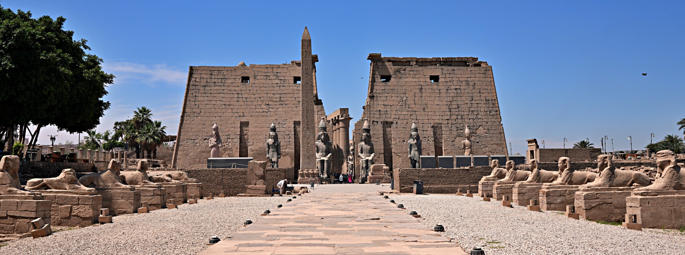
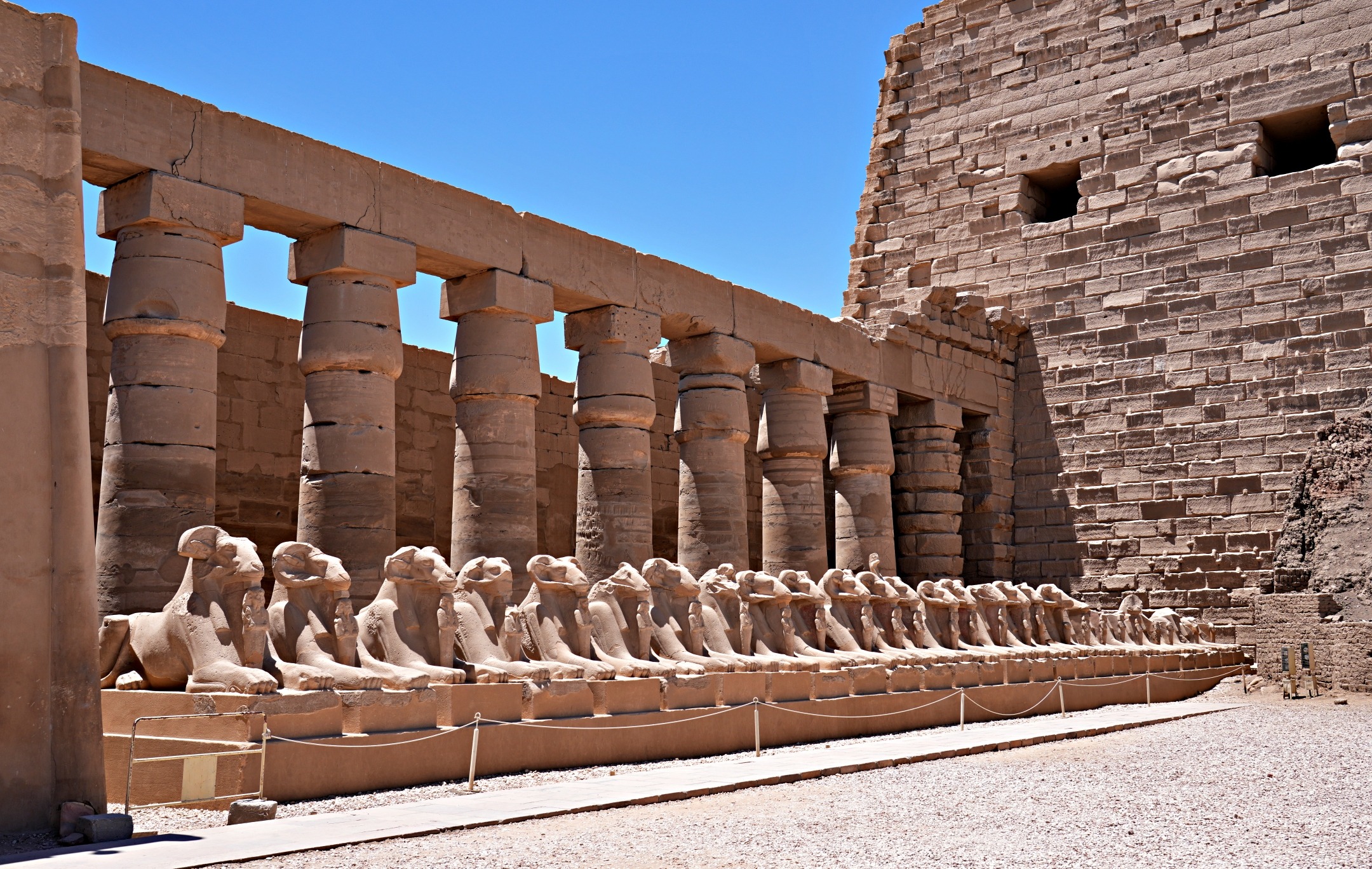
One of the first notable places you’ll pass is the city of Mtskheta. If you haven’t already visited Mtskheta and Jvari Monastery from Tbilisi, you could stop to visit them on the drive since the Georgian Military Road passes right beside the city. Mtskheta is the city where the country was first declared a Christian state in the 4th century. With such a long history, there are many important places to visit in Mtskheta.
Read more about these sites in our post, Georgia’s First Capital, Mtskheta and Jvari Monastery.

Zhinvali Reservoir Viewpoint
A further 40 km up the road is one of the most stunning scenes on the drive. In the 1980s, the Soviets dammed the Aragvi River to provide the city of Tbilisi with water and electricity. The result was the creation of the very pretty Zhinvali Reservoir. The damming was controversial at the time because it flooded a village and an archeological site, but today, it is enjoyed by many.
The large reservoir is very picturesque and is a popular day trip from Tbilisi. While you’re there you can rent kayaks, SUPs or even take a boat trip on the reservoir. There are also several places for picnics and a few restaurants along the ridge and down at the water’s edge.


Ananuri Fortress
Sitting on the edge of the reservoir is the picture-perfect 16th century Ananuri Fortress. Within its fortified walls are two castles and three churches. Like most historic fortresses, Ananuri was the site of many battles between feudal dynasties, in one, the fortress was set on fire.
Although it is mostly in ruins, the long rampart, tall towers and its stunning setting beside the reservoir make Ananuri Fortress worth a visit.
There is no fee to visit.


Russia–Georgia Friendship Monument
As we wound our way higher up the grassy mountains, our eyes were glued to the spectacular mountain scenery. Hoping to take a closer look, we had just asked our driver if we could stop soon, when we reached a very popular spot on the drive, the tacky Russia-Georgia Friendship Monument. While we weren’t impressed by the monument, the vista from this open area did. We were surrounded by snow-capped peaks towering over green mountains, and dramatic ravines carved into the valleys below. These breathtaking views are what make this stop a must-see.
The monument was built by the Soviets in 1983 to commemorate the Treaty of Georgievsk in 1783. The treaty was intended to ensure Georgia’s security as a protectorate of Russia, while allowing it a certain degree of independence. It didn’t last long, though, because by the 1800s, Georgia was annexed by Russia. This history makes the monument even more strange.


Jvari Pass
The road to Jvari Pass (Cross Pass) weaves its way up through the verdant, green mountains, in one continuous feast for your eyes. It’s usually a slow climb due to the number of semi-trucks hauling their goods into Russia. The Georgian Military Road is the main route, not only for Georgian transport trucks, but also for Armenian and Turkish ones.
A tunnel is being built so these slow-moving trucks can avoid the pass. Once completed, the road to the pass will still be open to tourists, but hopefully, the tunnel will make the drive easier because the trucks will no longer slow the climb to the pass. It is projected to be completed by the end of 2025.
As if slow semi-trailers weren’t stressful enough, you must contend with another common user of Georgian highways. On this drive, we could see large herds grazing high up on the hills, but there were also several cows on the road. Some were crossing, but many were lying in the middle of the busy highway. They apparently like to lie on bridges to take advantage of the cooling breeze. They make the drive even slower and more hazardous.

At 2,414 meters high, Jvari Pass is the highest point on the Georgian Military Road. We had thought we’d stop at the pass and be treated to more spectacular views. Unfortunately, it is a very long, green pass and doesn’t have a scenic top.
Jvari Travertine
Coming down the north side of the pass, we saw what looked like a frozen waterfall trickling down the side of the green, grassy hill. It is actually a mound of travertine, formed by deposits left from mineral springs. The large formation of white and orange stone contrasts this otherwise green hill. The view is much better from a distance, but there is nowhere to park on the highway to take pictures until you reach the base of the ‘waterfall’.
Near the parking lot is a tap where you can fill a jug with mineral water. When we stopped, there was a lineup of people with containers, waiting to take some of the water home. There are actually a few of these taps along the drive.

On the north side of the pass, we saw the ruins of watchtowers dotting the hilltops. They are left over from the days of threats from invading tribes such as Chechens, Dagestanis and even Turks. The one in the picture below was accompanied by a church, another common sight.

Not far from Stepantsminda, we drove through the ski resort town of Gudauri. We didn’t expect such a large community to be spread all the way up the hill. We had originally thought of spending a night in the resort town, but in the summer, there’s not much to do and while the views are nice, they’re not spectacular. It is likely a busy place during ski season.
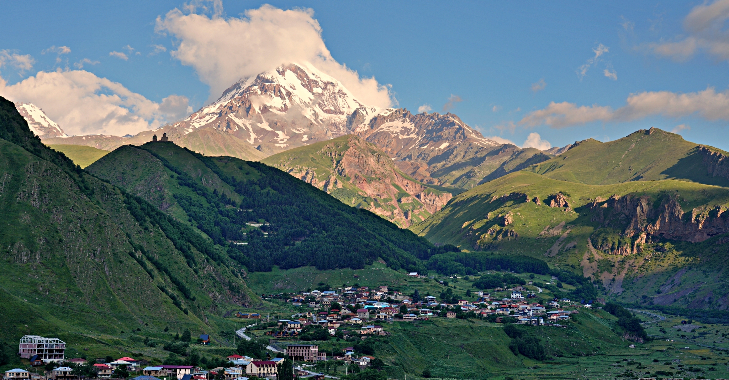
Stepantsminda
Not far from the Russian border is the mountain town of Stepantsminda. Its name comes from a hermit monk named Stephan, who had a hermitage in the area. He is credited for saving the town by advising residents to relocate their homes out of a hazardous avalanche zone. In 1925, the Soviets renamed it Kazbegi after a Georgian lord who was a Russian loyalist. Famed Georgian author Alexander Kazbegi was the grandson of this loyalist and grew up in Kazbegi.
In 2006, the town changed its name back to its original Stepantsminda, but it is still commonly called Kazbegi. Stepan Tsminda translates in English to Saint Stephan.


Whatever the name, it has a stunning location set between the tall peaks of Mt. Kazbek and Mt. Shani. At 5,033 m (16,512 ft), Mt. Kazbek is the third highest mountain in Georgia, and the second highest volcano in Europe. Like many high mountains, its summit is often shrouded in clouds. We were lucky to see the snow covered peak a few times during our stay.
The mountain’s name in Georgian is Mkinvartsveri, means ‘Glacier Peak’.

If you’re familiar with Greek mythology, you may know the story about Prometheus. In the legend, Prometheus was chained to a rock as punishment for stealing fire from the gods and giving it to the mortals. Many say this rock is located in Betlemi Cave, located high up on Mt. Kazbek. Not all agree, though. Others believe it was on Mt. Elbrus in Russia. You can read about Richard’s climb on Elbrus here.
We visited another site in Georgia, Prometheus Cave, but it is has no connection to the fable, other than the name. You can read about it in our post Day Trips From Kutaisi – Martvili Canyon and Prometheus Cave.


Located only 11 km from the Russian border and on the side of the Georgian Military Highway, Stepantsminda is a common destination for travellers and mountain enthusiasts. At an elevation of 1,740 meters (5,710 ft), the air is a little cooler in Stepantsminda, even during midsummer. That alone makes it a nice place to visit, but its mountain setting also makes it a great base for exploring the Caucasus.
On the other side of the highway, the village of Gergeti would also be a great place to stay.


Gergeti Trinity Church
The most famous landmark in Stepantsminda is Gergeti Trinity Church. Its location on a ridge below Mt. Kazbek makes it even more intriguing. We could see the hilltop church from Stepantsminda and were excited to hike up and see it closer.


There is a road all the way up to the church, but we’ll take you on the hike to Gergeti Trinity Church in our next post, Day Hikes in Stepantsminda. (Coming Soon)
Ioane Natlismcemeli Monastery
On another hill above the town is the cute 18th century Ioane Natlismcemeli Monastery (St. Ilya). Its setting is very dramatic with the rocky slopes of Mount Shani (4,451 m) right behind. The church is joined by two small chapels, a cross and monastery buildings.
It’s an easy 1 ½ hour walk from Stepantsminda to reach the picturesque monastery from Stepantsminda.


Inside one of the chapels, we were surprised to see the restored walls decorated in colourful frescoes.


Walk Details
Distance 3.6 km; Elevation gain – 210 m
We had hoped Stepantsminda would be a cute mountain town. Even though it’s located on the busy highway to Russia, it acts as though it is very remote. Store shelves were empty; the roads are full of potholes; and restaurants have the highest prices we saw in all of Georgia. So it’s not the idyllic mountain town we had hoped for, but it provides a base to explore this wonderful mountainous area.
You can read about the hike we did in this region in our post Day Hikes From Stepantsminda. We also explored more of Georgia’s mountains. In the coming weeks we’ll take you to the isolated communities of Tusheti and then on a hike between villages in Upper Svaneti.
When to visit Stepantsminda
Because it can snow from October to April, the best hiking weather in Stepantsminda is between late May and mid October. These dates may vary based on the timing and amount of snow. July and August will be the busiest months, but summer has the best weather for hiking. But remember, the area is often cloud-covered and receives 800mm of rain in the spring and summer months, so you are not guaranteed good weather. In the winter, most of the hiking trails are not accessible, and the ski resort town of Gudauri is a more popular option.
How to get to Stepantsminda
Marshrutkas leave Didube Bus Station in Tbilisi for Stepantsminda beginning at 8 am and leave when full. Marshrutkas won’t stop at any of the viewpoints, so if it’s your first time visiting, you will likely want to hire a private driver such as GoTrip Georgia. If you have a car, you can drive yourself, but it is a busy highway. There are many semi-trailers hauling loads to and from Russia, and most go very slow up and down the pass, backing up traffic. If that’s not enough, you must keep your eyes out for cattle walking, lying or standing in the middle of the highway.
Marshrutkas return to Tbilisi beginning at 7 am. The sign states that there is one marshrutka an hour, but they tend to leave when full. Many travellers take a private driver to reach Stepantsminda, but take a marshrutka back. Therefore, there are more people so plan to arrive early, to ensure you have a seat.
Getting around Stepantsminda and area.
Many of the hikes are a few kilometers outside of town. Mountain Freaks operates shuttles to many of them. Their office is on the main street in Stepantsminda. There are also several taxis willing to drop off and pick you up at an arranged time.
Where to stay in Stepantsminda
If you don’t have a car, the easiest place to stay is right in Stepantsminda, where there is a wide range of accommodation from budget to luxury. The town is very small, so where you stay is not as important. Keep in mind that the main street is relatively flat and the roads climb up the hill as you move east from there. Another option is the village of Gergeti, on the other side of the river, where you’ll find quite a few guesthouses and restaurants.
If you have a car, it might be nice to stay in one of the smaller communities along the way.
Where to eat in Stepantsminda
For some strange reason Stepantsminda is one of the most expensive towns for dining that we experienced in Georgia. Prices are higher than similar restaurants in Tbilisi.
For a take-away lunch or snack, we loved Lunch Time. It’s located around the corner from the marshrutka stand and has amazing, freshly baked breads stuffed with bean paste, cheese, potatoes or beef. A nice, local restaurant is Dootsi. It has good food at reasonable prices in this expensive town. Their Americano is also very good, which is not common in Georgia. You can find it above the marshrutka stand, but the sign only says café.

Click on the link to read our Travel Tips For Georgia.
To read more of our adventures in Georgia, click here.
Coming Next – Day Hikes From Stepantsminda
For pictures from other blogs go to Gallery at monkeystale.ca
To read about more of our adventures go to Destinations.
If you like what you read, please comment or share (with credit) using the links below.


We'd love to hear from you, please leave a comment.