
This is an incredibly beautiful trek with lush, wide valleys and high rocky peaks. Much of the trek is above tree line so the views are constant. The trek passes a number of glacier fed alpine lakes surrounded by 6000m peaks. For the full story and all the pictures from our trip click here.
The following information is based on our experiences on the Great Lakes Trek in Kashmir. It is not intended to be a guide, but hopefully will provide extra helpful information.
- We included our trekking times. Note that times do not include breaks and we only carried small day packs.
- We trekked in July 2018.
- We used a trekking company out of Srinagar (Budget Trek Kashmir) who provided all meals, tents, transportation, pack mules. You need to bring your own lunch box and spoon. Many trekking companies take large groups in India. Our’s was 15 trekkers which we thought was big, but another group had 38! We were very happy with Budget Trek Kashmir and would recommend them.
- We did the trek in 6 nights, 7 days, but most agencies advertise one day longer. They planned a rest day on the last day, but it was raining so we went down early.
- This trek is a camping trek, there are no amenities along the way, only 2 small tea houses serving snacks and drinks. Our trekking company did not provide water, not even boiled. There are many streams to get water, but bring your own filtration/drops etc.
- Trekking permits are required. Ours was arranged through the trekking company.
- There are 4 army check points where you have to show your passport.
- In July it was hot during the day with a strong sun, but evenings were chilly. We had summer sleeping bags and were warm enough.
Day 1 – 2 ½ hr drive from Srinagar to Sonamarg
The trekking company picked us up at the pier near out houseboat. It was an uninteresting 2 1/2hr drive. We trekked to the valley behind our campsite on our own, as there is no other trekking on day 1.


Day 2 – Sonamarg to Nichinni, (3 1/2hrs), ascend 900m


The trek climbs easily up green hills to the 1st army check point. Nearby are interesting shepherds’ summer huts. Continue to climb up green hills to reach Table Plateau and a small, basic tea house. From here the trek goes through a birch forest to reach a long, wide rocky valley that follows a river. Follow the valley, passed a gorgeous waterfall to a large open meadow where most groups camp at 3600m .
Day 3 – Nichinni to Vishansar (3hr 35 min) via Nichnai Pass, ascend 500m, descend 500m


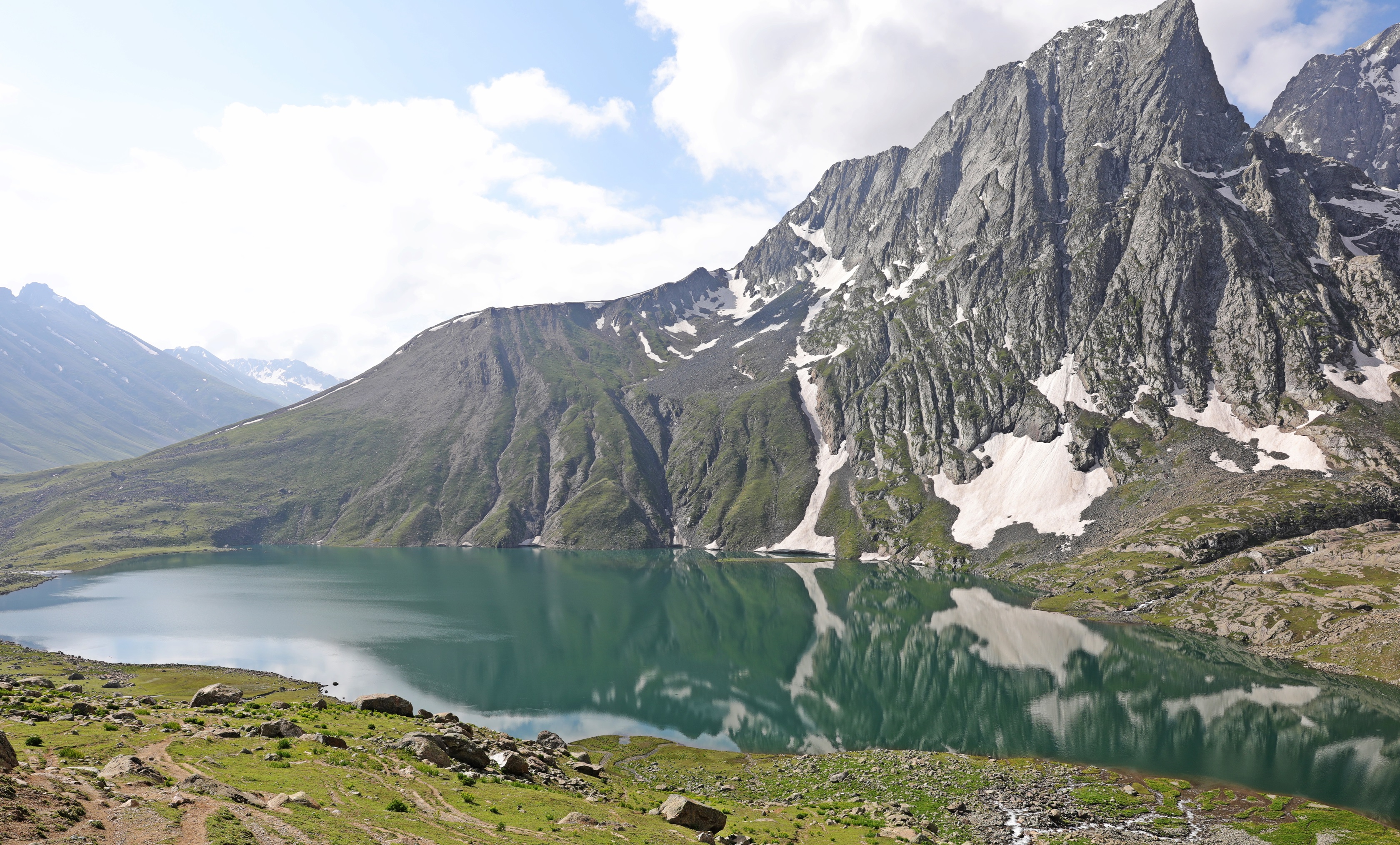
The trail continues to the end of the valley where there is a river crossing (ford or skip over rocks). At the end of the valley is a fairly steep climb beside a waterfall to the false pass and a lookout. It continues as a gentler climb up the wide Nichnai Pass until the last 50m which are steep (4100m,1 ½ hrs). There are beautiful views of the valley ahead with rugged, spikey peaks and 2 small glacier lakes. The trail descends gently down from the pass across small snow fields to reach the wide, alpine flower filled valley with beautiful waterfalls. Half way down the valley look back for a postcard view. At the end of the valley, round a hill to your left to reach camp in a large open meadow at 3645m. 10 minutes further up this meadow is the Great Lake Vishansar Lake surrounded by large mountains.
Day 4 – Vishansar to Gadsar, (5hr 5min) via Gadsar Pass, ascend 555m, descend 810m


The trek climbs the hill to climbers right of the lake where you have more views of Vishansar Lake. On the other side of this hill is the Great Lake, Krishnasar Lake. Cross in front of this lake to see the trail to the pass. It’s a moderate climb with a few steep sections, but you can see the pass from the bottom of the trail. Gadsar Pass, 4200m, offers stunning views of the 2 lakes and the mountain range behind. On the other side of the pass is a large green valley filled with even more alpine flowers than the previous day. The trek follows this valley passing the gorgeous Gadsar Lake to the end of the valley where it goes left to reach an army check point. Camp is not far from this check point and is also called Gadsar at 3400m.


The trek heads up the left side of the valley slowly climbing a moderate trail on the large, grassy hill. From the highest point (approx. 150m) you may be able to see mountains in Pakistan if you have perfectly clear skies. After rounding the hill, the trail drops to a river and then climbs a small hill to another army check point. (2hr 15min). We took a side trip up the ridge that is NW of the check point to another lovely alpine lake surrounded by rugged peaks. (1 hr return, approx. 150m gain). You have to return to the check point before continuing on the trail. The trail continues down the valley, passed a small pond, over a boulder field surrounding a small lake. Camp is just down from this lake in a gorgeous cirque surrounded by rugged mountains at 3700m. Across the river is another mountain with a waterfall. We did a 2nd side trip to one of the 7 Satsar Lakes above this waterfall. The trail goes climbers left of the waterfall. (20 – 30 min, approx. 150m gain). There’s another trail around the right side of the lake to climb beside the waterfall to a small cirque with another Satsar lake. This area is usually cloudy, with low, misty clouds. The clouds broke up a few times, so we were able to get nice views.
Day 6 – Satsar to Nundkol (2 hr 40 min) via Jaj Pass 4100m, ascend 400m, descend 500m


The trek climbs a small hill beside camp to a boulder field. Crossing the boulders is not difficult, but our guides made it sound very challenging. The boulder field is approximately 300m wide. After the boulders you cross a green hill to a small meadow. At the end of the meadow is a moderate climb to Jai Pass, 4100m (1hr 20min). At the pass you may have beautiful views of 3 alpine lakes and rocky mountains, but we could only see clouds. It’s a steep descent from the pass on a dirt trail with loose rocks. There are many switch backs until you reach a gentler green path. You cross a couple of small meadows and hills until you can see the 6th Great Lake, Nundkol Lake below. Camp will be at the side of the lake at 3600m. It is easily accessible from the other side so is a common site for Kashmiris to camp for a few days. Whether it is them, or the trekking groups I’m not sure, but there is a lot of garbage at this camp site. It’s really unfortunate as it spoils a gorgeous site.
A 10 minute walk from this lake is the 7th Great Lake, Gangabal Lake.
Day 7 Nundkol to Naranag (3hr 35min) descend 1100m
Many groups spend 2 nights here to explore Gangabal Lake and to rest. When we were here it was raining so we only stayed one night. The trek out begins very easy with a few ups and downs over the grassy hills. After 1 ½ hrs you reach a basic teahouse and have only descended 200m. After the teahouse the trail steeply descends through a birch, fir and pine forest on a dirt path with fine ball-bearing rocks under foot. It’s a knee-jarring 900m down with not much of a view. You arrive at the town of Naranag after 3hr 30min where there are jeeps to take you back to Srinagar (1 ½ hr drive).
For more of our treks click here, or go directly to Phuktal Gompa (Zanskar), Hidden Valleys (Ladakh), Markha Valley (Ladakh), Everest 3 Passes, Manaslu Circuit, Upper Mustang, Jumolhari Yaksa Trek (Bhutan), Kalaw to Inle (Myanmar) Pinnacles Trek (Borneo), Dong Van (Vietnam), Carstenz Pyramid.,
For pictures from Richard’s Everest climb click here: https://www.youtube.com/watch?v=VFmsecd6yN0


