
Manaslu is the 8th highest mountain in the world. We did the Manaslu Circuit Trek in Nepal in May 2018. It’s a nice trek with great views from days of the Manaslu and Annapurna ranges and is less traveled than other Nepal treks. We did the trek in 9 days, but if you’re not acclimatized plan to spend around 12 days. It has a lot of climbing as it begins at only 730 m and climbs to the pass at 5105 m. The following information is based on our experiences on the trek. It is not intended to be a guide, but hopefully will provide extra helpful information.
- We did the trek in May 2018. At that time, you had to have a guide as it is considered a Restricted Area. Consider paying for guesthouses and meals on your own rather than through your guide. That way you can choose a place that suits your needs rather than the guide’s.
- We included our trekking times. Note that we were already acclimatized but were carrying our own full packs. Times do not include breaks.
- There are many guesthouses along the trail, but not nearly as many as other treks in Nepal.
- Permits are required to trek in Manaslu, including an Annapurna permit, and will be obtained by your trekking guide.
For the full story and more pictures of our trip click here for part 1 and part 2.
Day 1- Soti Khola to Machha Khola (3hr 30 min), ascent 330m, descent 80m

After a harrowing day and a half of Jeeps and buses on back roads, we were ready to start trekking. Buses and Jeeps only go as far as Soti Khola, but the trail follows the newly built dirt road for a while longer. The road travels along the mountain edge above the Buri Gandaki River. When we were there the road wasn’t complete so there were no cars past Soti Khola. The temperature and humidity were very high so be prepared with a lot of water. There’s an alternate trail along the river, but when we were there it was flooded and required a hip deep ford. Maccha Khola (930m) is a small village along the Buri Gandaki with a few guesthouses to chose from.
Day 2 – Maccha Khola to Jagat (5hr 35min), 510 m ascent

The trail continues along the road above the deep narrow gorge of the Buri Gandaki until the village of Tatopani (2 hrs). From there the road ends and it is a good trekking trail continuing along the river valley with many small climbs and descents and river crossings on suspension bridges. Eventually you reach a metal suspension bridge that is attached to the steep rock face and takes you along the mountain’s edge until finally climbing down to a meadow. From here there is one more bridge and one last climb up stone steps to the village of Jagat (1370m). There is water purification station here, the cost less than 80 Rupees/L. The higher you get, the more expensive it is to purchase water, chocolate etc.
Day 3 Jagat to Deng (6hr 10min), 550m ascent, 80m descent


After Jagat the valley opens up a bit and you have views of Sringi Himal’s peak. The trail has a lot of ups and downs on its way up 550 m to 1800 m. You pass thorough many small Gurung villages which have Buddhist mani walls, chortens and kanis. 1 ½ hrs from Jagat, in the village of Philim, is another water purification station. The vegetation changes as you get higher with pine and bamboo trees and wild yellow raspberry plants, a few rhododendrons and wild marijuana. You start to see more waterfalls in this area as you approach Deng (1540m).
Day 4 – Deng to Namrung (5hr 26min), ascent 1100m, descent 240 m


From Deng you have great view of mother-daughter peaks and after 45 minutes you get your first view of Manaslu’s snowy peak. The trail has a lot of elevation gains and losses on its way up the valley, many times on stone steps and 4 or 5 suspension bridges river crossings. There are many waterfalls on both sides of the valley. The Buddhist features here are very interesting including one above Gap that has intricate carvings of Buddha in various postures. The river starts to narrow and becomes very fast, pummeling its way through and around may boulders. At the ACAP ‘1 ½ hours to Namrung’ sign, the trail climbs on mostly stone steps all the way up to Namrung, from 2300m to 2660m. Don’t take the short cut as it has been taken out by a landslide and is no longer passable. Namrung (2660m) is a small village with a couple of guest houses and a new expensive hotel.
Day 5 Namrung to Samagoan (5hr 30min), ascent 1180m, descent 310m


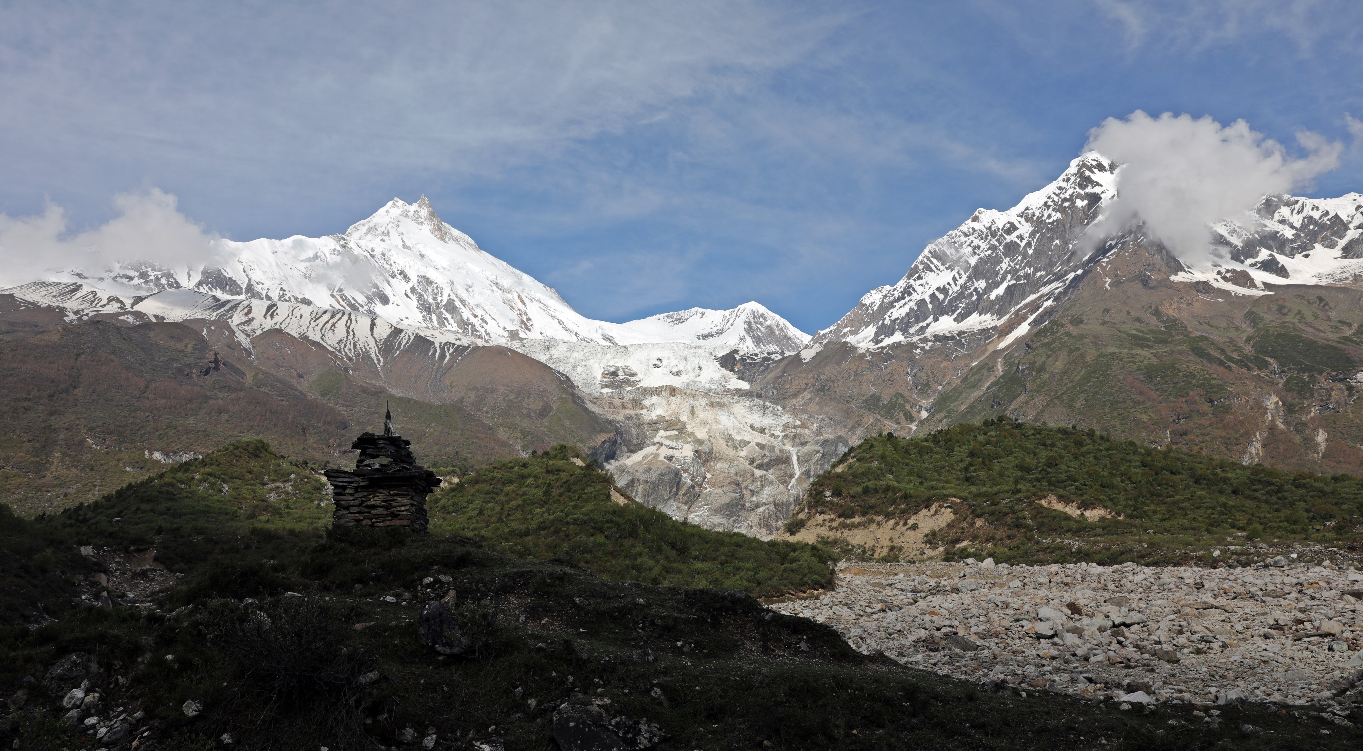
Leaving Namrung on a series of stones steps with a few smaller ups and downs there are more chortens, mani walls and kanis from here and they are more elaborate. The village of Lihi has interesting row-house style stones homes. There are few river crossings over the smaller side gorges, but soon the valley opens up and you have views of Manaslu, Manaslu North and Naike Peak. You pass a couple small villages with fields of corn barley and potatoes and then reach the larger village of Lho Gaou (3180) (2 hr 30 min). Many people stay here, but since we were already acclimatized, we continued higher. There are many guesthouses in Lho. There are a few more ups and downs, much larger than before Lho. The trail goes though forests of fir, pine, oak and rhododendron. Pass the large villages of Shyala with beautiful mountain views. Another descent and a long ascent brings you above Samagoan (3525m). It is a very large village with interesting homes. These stone homes share a wall with their neighbour, but each has their own roof and a space below for their animals . There are great views of Manaslu and other peaks from Samagoan. We were lucky to have a beautiful sky and a gorgeous alpenglow on Manaslu one morning. There are a few day trips from Samagoan for further acclimatization, most people spend at least 2 nights here. Manaslu base camp is situated above the glacier. We were planning on trekking here, but the weather didn’t cooperate. It’s a full day return trip. Birendra Tal sits at the base of the Manaslu glacier and is about 30 minutes from town.

Day 7 Samagoan to Dharmasala (4 hr 11 min), ascent 4480 m


From Samagoan the trail follows a wide, flat valley which allows for views of Manaslu. After 20 minutes you pass a memorial to climbers from France and Canada who died in 2012. The trail is mostly flat until just before Samdo (3860m, 2 hrs) where there is a steep climb again to a kani, a short drop and then a climb to the village. Some people stay in Samdo for the night. After Samdo the trail drops down to cross the Buri Gandaki and then climbs steeply for a short time and then it’s a gradual climb up the wide valley with a few drops into the gorges. You get great views of Samdo Peak and Manaslu North as you get higher. Depending on the season the valley may have many alpine flowers and flowering shrubs,. You’ll eventually reach a lookout point where you can see Dharmasala (4460m) in the distance. The climb continues its easy ascent to the old stone buildings that is the dining hall/kitchen. There are many tents available and a few rugged rooms. There were a lot of blue sheep very close to the hut when we were there.
Day 9 Dharmasala to Larke La to Bimtang (2 hr 33 min to pass, 5 hr 3min total), 810 m ascent, 1570 m descent


The trail continues a moderate climb up the valley for about an hour, then you reach the large moraine and spend the next 1 ½ hrs crossing it on a well marked trail. Its still mostly a gentle ascent to reach the pass adorned with prayer flags. From the pass you have views of Annaurna, Chio Himal and other high peaks. The descent begins gradual, but once you reach the end of the moraine it’s a steep descent down a scree slope which is often covered in snow and ice. When we did it, there were quite a few areas with ice, but we were able to do It without micro-spikes or crampons. This varies with the seasons so make sure you ask ahead. The steep descent lasts for about 800m where it changes to a more gentle descent down a rocky trail beside a meadow with great views. It takes you to the village of Bimtang (3720m)which has several nice guesthouses with amazing mountain views. Bimtang has a gorgeous seting in a bowl surrounded by majestic peaks.
Day 9 Bimtang to Dharapani (6hr), 1200m descent


The last day of the trek involve 1200 m of steep, near constant descent. There are a few climbs and a few flat areas to give your knees a beak, but it is a long way down. The trail begins in sub alpine terrain with junipers and alpine flowers and then through a forest of pine, fir, rhododendrons and wild strawberries. The views are great for the first couple of hours leaving Bimtang and there are views of the Annapurna range before Dharapani, but otherwise you are in a dense jungle. Some will stop part way down in Goa (4hrs). There is road access to Dharapani so you can catch a jeep to Besi Sahar where there are many buses and minibuses to Pokhara and Kathmandu. It usually takes 5 or 6 hours to Besi Sahar, so most will overnight in Dharapani and take a ride the next morning.
For more of our treks click here, or go directly to Phuktal Gompa Zanskar), Markha Valley Trek (Ladakh), Kashmir’s Great Lakes, Upper Mustang, Everest 3 Passes, Jumolhari Yaksa Trek (Bhutan), Kalaw to Inle Trek (Myanmar), Pinnacles Trek (Borneo), Carstenz Pyramid.
To see our pictures from Annapurna click https://www.youtube.com/watch?v=IGL5XQNaWm8
To see pictures from Richard’s summit of Everest click https://www.youtube.com/watch?v=VFmsecd6yN0


