
Trekking through the High Atlas Mountains in Morocco allows you to see another side of this varied country. Tall, snow-covered peaks hover above modest mountain towns. In addition to the scenery, the local Amazigh (Berber) people will welcome you into their homes and allow you to see their way of life. Hiking the Two Valleys route is a truly unique hiking experience.
On the drive from Marrakesh, the High Atlas Mountains slowly revealed themselves to us, making our excitement for the hike grow. The Atlas Mountains travel 2,000 km (1,200 mi) from Morocco to Tunisia. Its tallest is Mount Toubkal (Jebel Toubkal) 4,167m (13.671 ft). It is the highest mountain in Morocco and the 3rd highest in Africa behind Mt. Kilimanjaro and Mt Kenya.
The links will take you to our stories about climbing those mountains.


An hour and a half after leaving the busy city of Marrakesh, we were in the quiet town of Imlil (1,740 m/5,700 ft). It looks like a typical mountain town in an underdeveloped country. The hilly streets are crowded with jeeps parked in front of guiding and outdoor gear shops. In fact, the downtown district is purpose-built, exclusively for the mountain tourism industry. Residents live in one of the many Amazigh (Berber) villages that climb the hills around it, most of whom work in tourism.


Two Valleys Trek
Day 1 – Imlil to Ait Aissa
Distance – 15 km (9 ¼ mi); Elevation – 500 m (1,640 ft) gain and 300 m (984 ft) loss; Time – 4 hrs walking plus breaks.
Finally, it was time to begin our trek. As we climbed the steep trail out of town, we looked back for better views of the snowy Toubkal Range. Even on a cloudy day, it is a pretty picture with the town of Imlil sitting in the valley below.

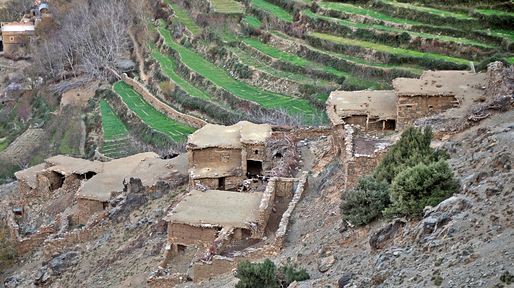
As we rounded the side of the ridge, we saw red sandstone mountains ahead and mud homes of Amazigh villages near their bases. Each family in these villages owns a plot of land where they garden. In the summer and fall, they grow turnips, corn, wheat, barley, cherries and apples.
Each family also has their own small walnut orchard. The nuts are harvested in the summer. They are not paper walnuts that can be cracked by hand. In order to crack them perfectly, the nuts are soaked in water for 1 or 2 days. After soaking, they are easier to open without breaking the nuts into a million pieces.


The higher we got, the colder it was. The sky was quite cloudy, and the wind whipped through our clothes. Spanish juniper and pine trees dotted the hills and soon we were walking in a sparse forest of them.

At the top is the very windy pass called Tizi Oudite (2,200m/7,220 ft) with views of Mount Toubkal’s snowy range. Other than Toubkal and its chain, the mountains are not high. They are more like hills than high mountains.


From the pass, we descended all the way down the valley, losing almost all the elevation we gained. Ait Oussadene Valley (also spelled Azzaden) is home to 4 or 5 Amazigh villages. Each is built into the side of the mountains. Ait Aissa village at 1,900m (6200 ft), would be our home for the night. Between the snowy ridge of Mt. Toubkal, walnut orchards and garden terraces, it has a lovely setting.


We stayed in a local guesthouse that was decorated in Amazigh designs on the crown moulding and ceiling. Tiled archways separate the living and dining areas. The pillars look wooden but are actually sculpted plaster. It was so nice to see the interior of these homes. Our guide said the decor is typical in this region.
He explained that all of the people living in the High Atlas are Amazigh. When the Romans arrived in North Africa, they called the local people Berber, which means barbarian. Next, the Arabs took over Morocco’s land and the Berbers retreated to the mountains and desert. They prefer to be called Amazigh which means ‘free life’ in the Tamazight language. Their alphabet, originally from the 4th century BCE, was only re-discovered 25 years ago. Under Arab rule, the alphabet, but not the language, slowly disappeared. Today it is taught in schools, but many of the older generation can’t read it.

We saw the Amazigh symbol throughout the country, it means freedom.

The houses may not be luxurious, but many of these humble homes have small hammams (saunas). They look like small copulas sitting in their yards.
We found it fascinating to walk around the village and see the homes built on the steep slopes. There is a mix of older compressed mud and newer cement and brick houses. Many of the old mud homes have been abandoned and were falling apart. In September 2023, a 6.9 magnitude earthquake struck Morocco’s Atlas Mountains, less than 60 km (35 mi) from Imlil. Most of the homes in this region were built with mud bricks and many collapsed. Almost 3,000 people were killed, and over 5,600 injured. On the hike, we saw a lot of rebuilding. Homes that were previously mud are being rebuilt with re-bar, reinforced concrete and brick. The government is providing financial assistance for temporary housing and to rebuild. It’s a long process though, and many people are still living in tents.


Day 2 – Ait Aissa to Aroumd
Distance – 15 km (9 ¼ mi); Elevation – 600m (1,970 ft) gain and loss; Time – 4 ½ hours.
Before the sun rose above the peaks, we left our cute guesthouse and began walking up the valley. We passed a few small mud villages that appeared to be clinging to the slopes high above. Their red earth colouring blended into the mountain walls. The last Amazigh village in this valley is Tizi Oussem. It received extensive damage in the 2023 earthquake. Men were already out rebuilding a house as we passed through.


As we continued to walk up the steep slopes above Tizi Oussem, we passed a couple of summer villages. Farmers bring their sheep and goats to these huts from spring until fall. They sustain themselves by growing vegetables. Before leaving, they plant barley in the garden terraces. The fields are covered in snow over the winters, so in the spring, the barley regenerates and can be harvested.
At one point we could see Tamsoult Refugio. It is used in the spring and fall by groups summiting Mt Toubkal.


From there, the incline was steady but more gentle as it worked its way toward Tizi n’Mazik (Pass). We found ourselves in another sparse forest of juniper trees, leaving the villages far below. The pass gave us a great view of Mt Toubkal and the villages that fill in the edges of Imlil Valley. The main one in the centre is Imlil. Although they are very close, each village has a different name. The largest village is Aroumv. We are going a little further up the valley, to the village of Aroumd.


From the pass, the descent was very steep on loose gravel through a sparse forest of pine and chestnut trees. Goat herders were taking their animals up the hill to find food.


Eventually, we reached Imlil Valley where we had a great view looking up to Mount Toubkal’s main summit (4,167 m/13,671 ft).


We stayed in a guest house in Aroumd at 1,900m (6,250 ft). It’s only a few hundred metres higher than Imlil, but it was very chilly at night. Our guesthouse owner lit a fire in a woodburning stove, and we all gathered in the main room for tea with the family’s cat.
Day 3 – Aroumd to Imlil
Distance – 10 km (6 ¼ mi); Elevation – 300m (985 ft) gain, 500m (16, 40 ft) loss; Time – 3 hours. Distances and elevations are approximates.
Around is directly beneath Mount Toubkal, so our route in the morning wound its way between huge boulders below the tall peak. It wrapped around a hill to enter Toubkal National Park where we crossed a forest of fir and pine trees. The government planted these trees to stabilize the slope and to provide trees for birds. The forest also had shrubs we weren’t familiar with. Their branches fan out like paintbrushes. They turned out to be ephedra, which is used in cold and weight loss medications in some countries.
A little further on and we found ourselves on a ridge right above Imlil. From there we could see Tizi n’Mazik, the pass we were on the day before.


Once back in Imlil, we went to the Women’s Argan Oil Cooperative. There are argan stores in most Moroccan cities, but most in the tourist areas don’t sell pure argan. In fact, what they sell is often mixed with olive oil or other cooking oil. Going to this cooperative with our guide, we are confident that we bought 100% argan. It wasn’t cheap at 100 ml for 200 Dirham (€19). You can find these cooperatives in many places in the country, they are usually a safe store to buy quality products.

While the scenery is nice, it’s not spectacular. Walking through the Amazigh villages and learning about their culture and history made the trip more than worthwhile.
Other treks – There are many other treks to do in this area. Depending on conditions, length of time you have and season you may be able to hike to the summit of Mount Toubkal.
Our guides – We used Trek Atlas for our 3 day-2 night trek through the Two Valleys. It is a locally run mountaineering firm. The owner, Ahmed, as well as our guide and cook were very experienced, professional, and spoke English. The food was very good, and we stayed in lovely guesthouses. We highly recommend them if you want to do a short or long trek in the High Atlas. Here’s a link to the Trek Atlas website. We do not receive compensation for this recommendation.
It is possible to hike independently, it would just be more difficult to find accommodations, but many can be found on Google Maps.
Getting to Imlil
The mountain town is only 60 km from Marrakesh. You can reach it by private or shared taxi. The Grand Taxi stand is near Jema El Fnaa Square. If you hire a guide, the transfer to and from Marrakesh is usually included.
You can find Imlil in the lower left area of the map below. Click on the image to be directed to an interactive map.


Click on the link to read our Travel Tips For Morocco.
To read more of our adventures in Morocco, click here.
Coming Next – Exploring The Port and Fortress of Essaouira
For pictures from other blogs go to Gallery at monkeystale.ca
To read about more of our adventures go to Destinations.
If you like what you read, please comment or share (with credit) using the links below.


We'd love to hear from you, please leave a comment.