
High in the Fann Mountains is one of Tajikistan’s little-known treasures. A deep gorge made by the Shing River holds seven breathtaking mountain lakes providing many more than seven stunning views. The colour of the water and the spectacular mountain settings make Seven Lakes (Haft Kul) one of the most stunning places in Tajikistan. If you love mountains and lakes, then this is the hike for you.
Haft Kul is the Tajik name for Seven Lakes. Haft means seven and kul means lake in Tajik. There’s not a lot of information available about hiking in this region, so we’ve included helpful information for the Seven Lakes Trek in Tajikistan.
To go directly to the trek details click here.
The drive to Seven Lakes
The owner of the guesthouse where we would be staying in the Seven Lakes area picked us up in Panjakent and drove us to the lakes and back. This was very handy because otherwise it would have been an uncomfortable ride in a share-taxi.
We had booked the guesthouse through our hotel in Panjakent. Before we left the hotel owner told us to bring our own food because the meals are very expensive in the small mountain villages. As an example, he suggested we bring our own watermelon. We couldn’t imagine packing a watermelon into our backpack and bringing it to a guesthouse! As it was, the meals were excellent, and we’re glad we only brought snacks and no watermelons.
Once we left Panjakent we drove through the arid Fann Mountains, passing small towns surrounded by columnar aspen trees. It was those pops of colour that let us know we were approaching a village.


After leaving the highway the drive is on a very rough, gravel road following the Shing River. We passed a speed limit sign saying 40 km/hr. The sign was very optimistic. There’s no way anyone could ever drive that fast while dodging the deep potholes and large rocks on the road. The further we got from Panjakent, the villages became smaller and more rustic.


After a while, we reached the village of Shing. Traditional stone and mud homes have been on these mountains for generations. In 2005 a mudslide covered most of a village. Almost all of the homes were destroyed. Incredibly only 4 people died. The lady from our guesthouse grew up in Shing and her parent’s home was destroyed. The government relocated many of the people to an area near the Uzbek border where they are apparently prospering. Those that remained continue to live on their cliffside location. In this earthquake prone region, it doesn’t seem like the safest place to have a house.

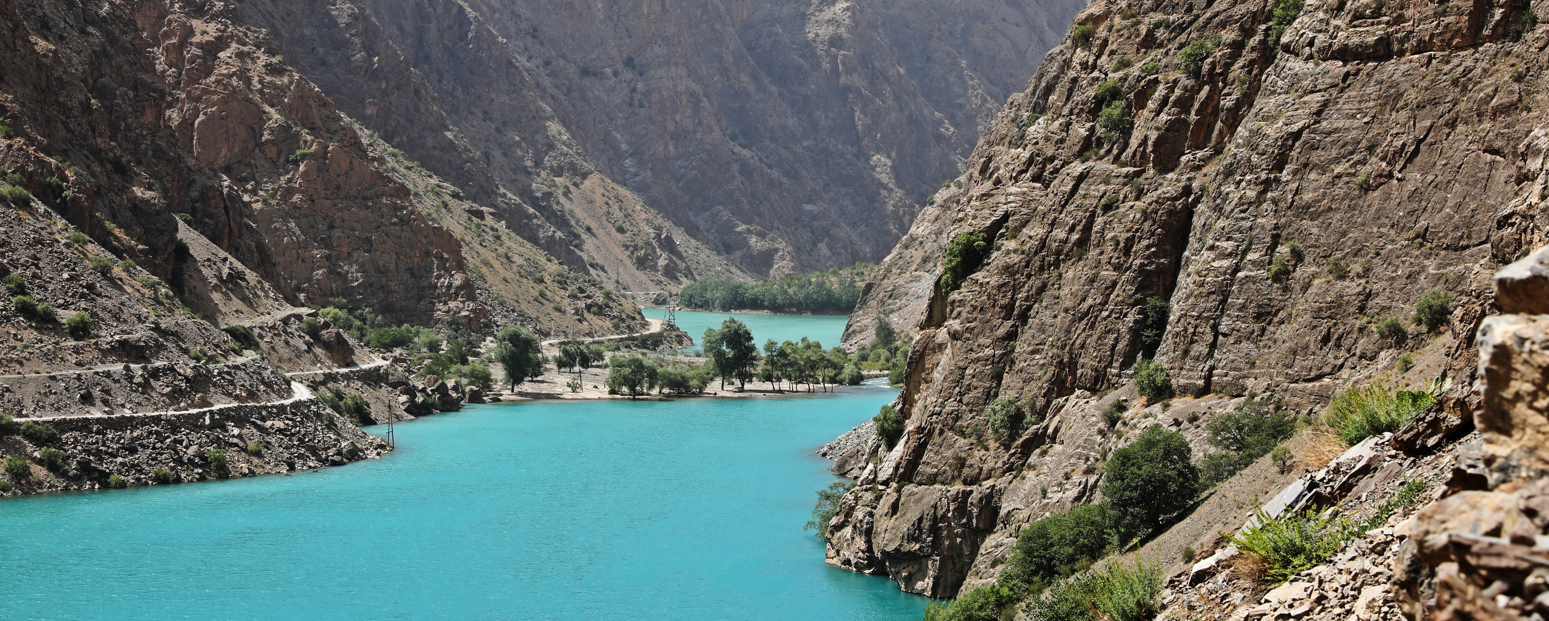
Above the village of Shing is the wonder of nature, called Haft Kul. The picturesque lakes are strung very close together in a narrow, mountain valley. As you would expect there’s a legend that explains how these lakes came to be. As the story goes, a man got lost while travelling in Shing Valley and his seven beautiful daughters went to search for him. When they couldn’t find him, they cried and cried. His daughters’ tears were so great that they formed lakes. In the end the seven girls drown in their own tears. Each lake is said to be as uniquely beautiful as each daughter.

The scientific explanation is that the lakes were formed when centuries of earthquakes caused large landslides that created multiple dams. These tall mounds of rubble blocked sections of the Shing River and formed the lakes.
Lake 1 – Mijgon
At the top of the small hill we found ourselves beside the first lake, Mijgon (1,640 m/5,380 ft). A rough, gravel road is cut into the side of the steep mountain wall and follows right above the lake.
Lake 1 is a great introduction to the views you will see in the valley. The gorgeous teal blue lake is sandwiched between the arid peaks giving it a spectacular setting.

You can begin your trek anywhere along this road and have your driver pick you up at Lake 6, or anywhere in between. Walking allows you to take your time at each lake rather than passing by quickly in a car. We suggest beginning your trek at Lake 1.
At the end of the lake is a tall mound of rocks and rubble; the natural dam caused by the earthquakes. What was impressive to see was that the river has cut its way through the rock pile. Water is very powerful. Not even earthquake debris could stop it from tunneling its way through the natural dam.
There is a hotel near the dam, but we don’t know much about it. Our guesthouse told us it was only used by drunks and prostitutes. She didn’t know many English words, but funnily she knew the word prostitute. We’re not completely sure, but we think it is a party spot for young Tajiks.

It’s about a 100 m (330 ft) climb on steep switchbacks to reach the top of the dam. When you reach the apex don’t forget to look back to see Lake 1 from a different perspective. From here we could understand why it is called Mijgon which translates in English to Eyelashes. The shape of the lake does look a bit like the eyelashes of two eyes.
The colour of the lake varied on the different days we saw it, which is apparently common for this lake. Its colour is due to a high sodium and calcium content.

Lake 2 – Soya
Almost immediately after climbing up the dam at the end of Lake 1 you descend 40 meters (130 ft) to be in front of Lake 2 (1,700 m/5,580 ft). It is called Soya, which translates in English to Shade. We had read that it spends most of the day in the shade, but we were lucky to see it twice in full sun.
Soya is a small green lake and apparently is popular with local fishermen. Each time we passed the lake, there were a few men with their fishing rods in the water.
The beauty of this area is that every lake is different in its colour, size, shape and surroundings. It’s quite amazing that there are not many tourists visiting such a gorgeous place. It is likely you will not see another tourist for the entire trek.

Lake 3 – Gushor
A small mud flat is all the separates Lake 2 from Lake 3 (1,700m/5,580 ft). Called Gushor, which means Nimble in English, it is a small lake with a spectacular mountain wall on one side. At its end is another dam approximately 120 m (400 ft) high. Once you climb a series of switchbacks to reach the top of this dam you are treated to a picture-perfect view of Lakes 2 and 3. At certain times of day you can see differences in their shades of blue.


Between Lakes 3 and 4 is a huge boulder field. The landslide debris is yet another reminder of how these lakes were formed. It would have been scary to have been there when these boulders came tumbling down the mountain. The road has been built between the boulders so unlike many boulder fields, this one is easy to walk through.
Lake 4 – Nofin
At an elevation of 1,820 m (5,970 ft), Lake 4 is just over 100 m (330 ft) higher than Lake 3. It is called Nofin which means Umbilical Cord. It received this name due to its long shape and pinched in sides. The emerald green water is so clear you can see some of the boulders under the water.


We walked along the side of the 2.5 km (1 ½ mile) long lake admiring the steep slopes on the other side. High above the water, a few houses seemed to be clinging to the steep incline of the mountain. They looked as if they may slide off at any minute.


Halfway along the lake is a deep inlet with a lush, green landscape composed of trees and grass. This green oasis surrounds the village of Nofin. We didn’t go through the village at all, but we could see the rooftops of houses from the lakeside.
You can stay at one of the two guesthouses in Nofin.

Padrud Village
Once you get to the end of Lake 4 it’s a flat walk to reach village of Padrud at 1,820 m (5,970 ft). Set beside a fast-moving section of Shing River, the village is a mix of new and old stone homes built into the steep hill. As we walked through town, a few children came running out to meet us and say ‘hello’. We tried to ask them questions, but hello was about as far as the conversation got as none of them spoke English. The welcome didn’t just come from the kids. A group of men were sitting beside the mosque. As we approached they said ‘Assalom’ (hello) and put their right hand on their heart. It is a common gesture in Tajikistan and is very endearing.
We stayed at the only guesthouse in Padrud Village and asked the owner’s daughter if she has friends in nearby Nofin. She said she didn’t know anyone from there. It seemed strange that kids from these two remote villages that are only 2 km apart wouldn’t try to get to know each other.


Lake 5 – Khurdak
There’s about a 50 m (154 ft) climb to get through the village of Padrud. Once you’ve reached to the top you’ll find the small Lake 5, called Khurdak (Baby). Early in the morning the small lake was like glass reflecting the mountain’s image off its calm surface.
There used to be a Soviet hydro station above the lake and it is still the source of electricity for the village of Padrud.


Between lakes 5 and 6, there a spot of flat, lush land with several gardens. The river has a bit of room so it spreads out and irrigates the land. Beyond the gardens the road climbs 270 m (885 ft) up the hill in a series of switchbacks, but there are a few shortcuts for those on foot.

Lake 6 – Marguzor
Finally, you’ll reach a lookout above Lake 6 at 2,140 m (7,120 ft) elevation. The lake is named Marguzor which translates in English to Blossoming Place. It is the largest lake of the seven and many say the prettiest. We’re undecided as to which is the most beautiful. Richard agrees that its Lake 6, but Maggie prefers the view of Lakes 2 and 3. The views change so much throughout the day, that your favourite may change as well.
In the morning when the wind is light, the narrow Lake Marguzor provides the perfect surface to reflect a picture of the mountains on either side. A guesthouse is located not far from the viewpoint and likely has a gorgeous view of the lake.

As you walk further along the lake’s 2.7 km (1 ¾ mile) shore you can see small patches of green along its base. Rooftops of homes poke through between the rocks and trees. Then you notice more homes high up on the mountain wall. Small communities live year-round in these unlikely locations which are only reachable on foot or by donkey.


At the end of Lake 6 is a small community called Kiogli Village. The road brings you by many of the village farmhouses that are surrounded by vegetable gardens. In one spot it looked to be a weeping wall. Dozens of small waterfalls oozed out of the wall that separates Lake 6 from Lake 7.


At the far end of the village is a large hill of scree debris. The road climbs this hill but it is in very rough condition and not many vehicles are able to make it up. Most people will walk the road instead of driving.
We found an alternate way to get to the top. A hiking trail leaves the road and climbs the front side of the hill. From this trail we had incredible views of Lake 6. We thought this trail would be shorter than the road, but it wasn’t shorter at all. In fact, it took about half an hour longer, but the views were worth it.


At the top of the hill is a large, green meadow filled with alpine flowers. It seemed out of place in this arid landscape. The ground in the meadow was very soggy and it was difficult to find a way around it. Eventually we did and arrived at source of Shing River as it leaves Lake 7.


Lake 7 – Hazorhashma
Just beyond this meadow lies the last lake, number 7. Located at 2,400 m (7,875 ft), the lake is called Hazorhashma which means A Thousand Springs. The name refers to the dozens of streams and creeks flowing into it from the mountains above. There is no village at this lake but there is a flat green space beside the lake that is available for camping.


We loved our time hiking around Haft Kul, and know you will too.
Seven Lakes Trek Details
Distance From Lake 1 to Lake 7 – 15 km (9.3 miles)
Elevation Gain – 760 m (2,500 ft)
Trekking Time – 7 hours
- This is not a typical mountain trek as it travels along a gravel road instead of a trail. We believe though that walking is the best way to appreciate the unique beauty of each of the Seven Lakes.
- The trek climbs between 1,640 m (5,380 ft) at lake 1 and 2,400 m (7,875 ft) at lake 7. This is not considered a high elevation trek, but if you haven’t been this high yet you should take precautions such as drink plenty of water and descend to a lower altitude if you experience symptoms.
- There are no stores in Seven Lakes so bring enough water for your stay.
- The road runs beside each lake so you can begin your trek from any of the lakes depending where you are staying and how much time you have.
- We suggest beginning at Lake 1 and walking all the way to Lake 7. If you do this, your guesthouse or driver could drop you off at the beginning and pick you up at Lake 6 later in the afternoon. Note that vehicles don’t drive up to Lake 7.
- Even though most of the trek is on a gravel road, there is not much traffic. It is an out and back hike so you will return the same way you came up.
- There are a couple of multi-day treks that connect Seven Lakes to either Iskanderkul or Alovaddin. Or, if you have time, trek to one of the high mountain passes between lakes 6 and 7.
Best time to visit Seven Lakes
The best time to visit is between mid-June and mid-September. This is between the time when the winter snow has melted and before the snow begins to fall again.
Getting to the Seven Lakes
Located 60 km from Panjakent it takes over an hour to reach the first lake from Panjakent. To visit this area on a day trip you can usually book a driver through your hotel. We stayed two nights in a guesthouse in the village of Padrud and the owner picked us up and drove us back to Panjakent two days later.
Where to stay in Seven Lakes
There are a few guesthouses in the Seven Lakes area. Two are in Norfin; there is one in the village of Padrud; and another above lake 6. You can find them and their contact information on Google Maps. In summer 2023, our guesthouse, Mijgon, cost $15 USD per person for bed and breakfast. Lunch was an extra $3 USD each and dinner $5 USD each. It is a basic accommodation, but the rooms are clean, the meals are delicious and the family is wonderful. The father and young daughter have learned English from tourists staying at their home making it much easier to communicate. Make sure you bring enough drinking water for the length of your stay as well as snacks. There are no stores in Seven Lakes.
Click on the link to read our Travel Tips For Tajikistan.
For more of our stories from Tajikistan click here.
Coming Next – A Weekend On Iskanderkul
For pictures from other blogs go to Gallery at monkeystale.ca
To read about more of our adventures go to Destinations.
If you like what you read, please comment or share (with credit) using the links below.


We'd love to hear from you, please leave a comment.