
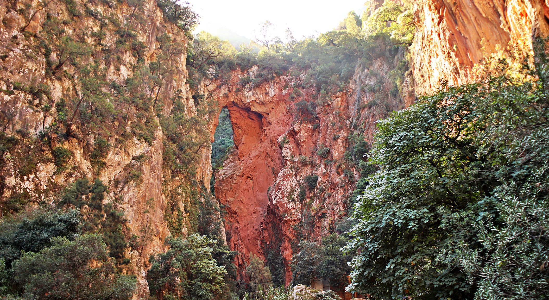
When you’re visiting the Moroccan city of Chefchaouen, don’t forget about these great day trips that allow you to explore the nearby rugged Rif Mountains. Hidden at the end of a narrow canyon is a unique, natural feature called God’s Bridge. Hiking to it, as well as the nearby Akchour Waterfalls are the perfect excuse to get out of the city for the day and enjoy nature in Morocco.
We weren’t very far outside Chefchaouen when we knew we had made the right decision to make this day trip. As soon as we left the city, the beauty of the Rif Mountains was revealed. You’ll find a completely different side to Morocco, only a short drive from Chefchaouen.
You can read about Chefchaouen in our post Visit Chefchaouen – Morocco’s Blue City.


Talassemtane National Park
This mountainous park is only 30 km from Chefchaouen but feels worlds away. Talassemtane National Park is an important biodiverse region, home to over 1300 species of plants. Around 50 are endemic to Morocco including the Moroccan Fir.
The most popular activities in the park are two hikes that begin near the village of Akchour. It is located at the confluence of two rivers and a dam marks the beginning of the trails. One trail follows the crystal clear Farda River in a tight canyon and takes you to a stunning natural feature. The other trail leads you to small waterfalls with swimming pools on the Kelaa River.


Behind the dam is a small reservoir with a dozen or more tagine stalls around its edge. As you walk by, pick your favourite so you can stop for lunch when you return later in the day. If you don’t know what it is, we describe the Moroccan dish tagine at the end of the post.
Just beyond the reservoir, a bridge links the two trails. This can act as a short-cut if you want to hike both trails.


God’s Bridge Hike
Distance – 4.8 km return; Elevation – 200 m (650 ft)
We planned on doing both hikes, but were most interested in seeing the rock feature, God’s Bridge, so we decided to hike to it first. From the y-intersection at the dam, take the trail on the right to follow the Farda River. The waterway is guarded by tall limestone cliffs which means there aren’t many mountain views. The canyon is pretty on its own though, so you won’t feel like you’re missing out on scenery.


The trail goes back and forth over the small river on handmade wobbly bridges or stepping stones. We did this hike in November, so the river was just a gentle brook. Listening to the sounds of birds singing and water flowing made it a very relaxing walk.
In spring, the mountain run-off will make it much fuller and faster. Also, during high season, the trails are likely much more busy, so it may not be as peaceful.


At the end of the trail, these cliffs form a tight cirque. At first, you won’t notice it, but if you look up, you will see a natural bridge over the river. God’s Bridge (Pont de Dieu) was formed over thousands of years of erosion from the Farda River as it roared down the mountains and carved a tunnel right through the rock. All that remains is a natural bridge, spanning the gap between the red limestone cliffs.


The river below has formed small pools. In the heat of summer, they are likely refreshing and filled with swimmers. In November though, the air was a bit too cool to tempt us to soak in mountain-fed pools.

The return route follows the same path back to the dam.
It’s a nice feature and the walk is relaxing, but it isn’t as spectacular as reported by some online.
Akchour Waterfalls Hike
Distance – 11 km return; Elevation Gain – 245 m (800 ft)
The other river is called Kelaa River. There are two waterfalls that you can see on this hike: Grande and Petite. Given the names, we had expectations of how they’d look, let’s see if we were right. Compared to the walk to God’s Bridge, this side of the valley is more open, allowing you to see the surrounding rocky peaks.
If you begin from the dam in Akchour, this trail is on the left side of the y-intersection. Remember if you’re doing both hikes, there is a small bridge, just upriver from the dam. It shortens the walk by a few hundred meters.


After walking and enjoying the mountain views for approximately 2 km, you’ll begin to see a few short drops in the river. Some have small pools at their base. One seemed a very popular hangout for the local ducks.


A little further on is a collection of small, make-shift cafés that serve tagines, drinks and snacks. Although they are right above Petite Waterfall, you can’t see the waterfall from here. Without a view, it was still the busiest place on the hike. That’s likely because, the trail to reach this spot is in good condition, easy to follow and doesn’t have much elevation gain.
Hidden below these snack huts is Petite Waterfall. A set of broken cement steps leads to the best viewpoint of the cascade. There’s a café on this spot, but in the fall, it was closed. It would be a nice place to sit and have a glass of orange juice while watching the water drop 10 metres over a grassy edge. Petite Waterfall is small, as its name suggests, but is quite picturesque.

As you continue walking upstream toward Grande Waterfall, the trail gets a bit rougher with steep, muddy sections, but is well marked with orange arrows and dots. It takes you through open areas where you can see the gorgeous tall, red mountains all around.


The trail goes back and forth across the river, but instead of wooden bridges, you have to hop hop between cement blocks that are remnants of washed-out bridges. In one area, we were mesmerized by strange plants floating in the river. They bobbed with the movement of the water, almost as if they were dancing. In addition to these plants, the picture below shows how clear the water is.

After 3.4 km (2 ¼ mi) you will reach a small cirque with a 70 m (220 ft) high moss-covered tufa hanging on the tall cliff wall. In spring, there’s likely more water cascading down, but for us, it was merely a fine trickle.
Tufas are formed when water collects minerals from the limestone as it drips down the cliff. They are deposited further down the wall forming different shapes. It is an interesting feature but difficult to call it a Grande Cascade.


You return to the dam on the same trail, so you can stop for lunch at one of the many stalls you saw on the way up.
The falls are not the most spectacular we’ve seen, but by combining it with God’s Bridge, it is a nice way to spend a day in nature.
Tips for hiking to God’s Bridge & Ackchour Waterfalls
- If you do both hikes, the total distance is 14 km with an elevation gain of 585 m. There is a small bridge across Farda River that takes you between the two trails. It’s not far from the dam but will save a few minutes of walking. Keep an eye out for it on the way up so you don’t miss it on the way back.
- There is no entry fee to the park if entering on foot.
- In November the God’s Bridge trail was good, but it is very close to the water and in the spring, the trail may be flooded.
- Hiking shoes or good runners are recommended.
- The trails are very clean. Help keep them that way by not littering.
- All trails are out and back.
How to get to God’s Bridge and Akchour Waterfall Hikes
It’s very easy to hike to God’s Bridge and Akchour Waterfall Hikes on a day trip from Chefchaouen. The Grand Taxi (share-taxi) stand is in front of the main bus station in Chefchaouen, Gare Routiere. These shared collectives will leave when they have 5 – 6 passengers. If you would rather not wait, you can take one as a private taxi for the fee of 5 or 6 passengers. This is still not a very expensive option at roughly €15 (150 MAD).
Taxis drop you off at the park gates, on the edge of Akchour. If you’re driving, you can also park here, otherwise you can park in town, but you will have to pay the park fees. From there, follow the main road through town for about 1 kilometre to reach the dam. The trail on the right of the dam goes to God’s Bridge. The waterfall trail is on the other side of the bridge and travels up the left valley. Grand Taxis pick up is at the same place you were dropped off.
You can find Chefchaouen near the top of the map below. Akchour is only 30 km northeast from the city. Click on the image for an interactive map.

Where to eat at God’s Bridge and Akchour Waterfall Hikes
There are several kiosks with plastic chairs at a few different places. You can find them at: the river confluence, around the reservoir and at Petite Waterfall. There are also a few others scattered along each trail, but in November, many were closed. Most sell tagines, juices, soft drinks and snacks. There are also many restaurants in town, just before the dam.
Tagine is the name for both the earthenware pot and the traditional Moroccan dish cooked in it. The stew-like meal usually includes meat such as chicken, goat, camel or lamb and vegetables such as tomatoes, onions, carrots, zucchini and potatoes. You can order it without meat. Tagine is typically slowly cooked over an open fire. Depending on the region, tagine may be flavoured with ginger, cumin, cinnamon and turmeric. We found that the amount of spices used varied and, in many regions, our meals were quite flavourless. The best-seasoned tagines we ate had a rich, earthy taste.


Click on the link to read our Travel Tips For Morocco.
To read more of our adventures in Morocco, click here.
You can read about our other treks in Morocco by visiting our post Two Valleys Hike in Morocco’s High Atlas.
Coming Next – A Guide To Explore Fez Medina
For pictures from other blogs go to Gallery at monkeystale.ca
To read about more of our adventures go to Destinations.
If you like what you read, please comment or share (with credit) using the links below.




We’d love to hear from you, please leave a comment.